Rush wrote that lyric in the song “Time Stand Still”, but it’s appropriate for where we are now, as some cooler weather is on the way as we flip the calendar to September and the beginning of meteorological autumn.
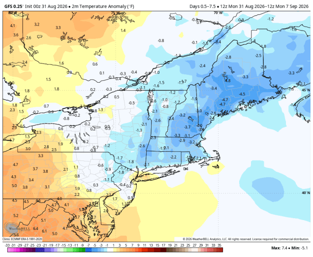
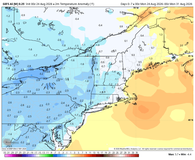
Temperatures will be below normal for much of this week. Image provided by WeatherBell.
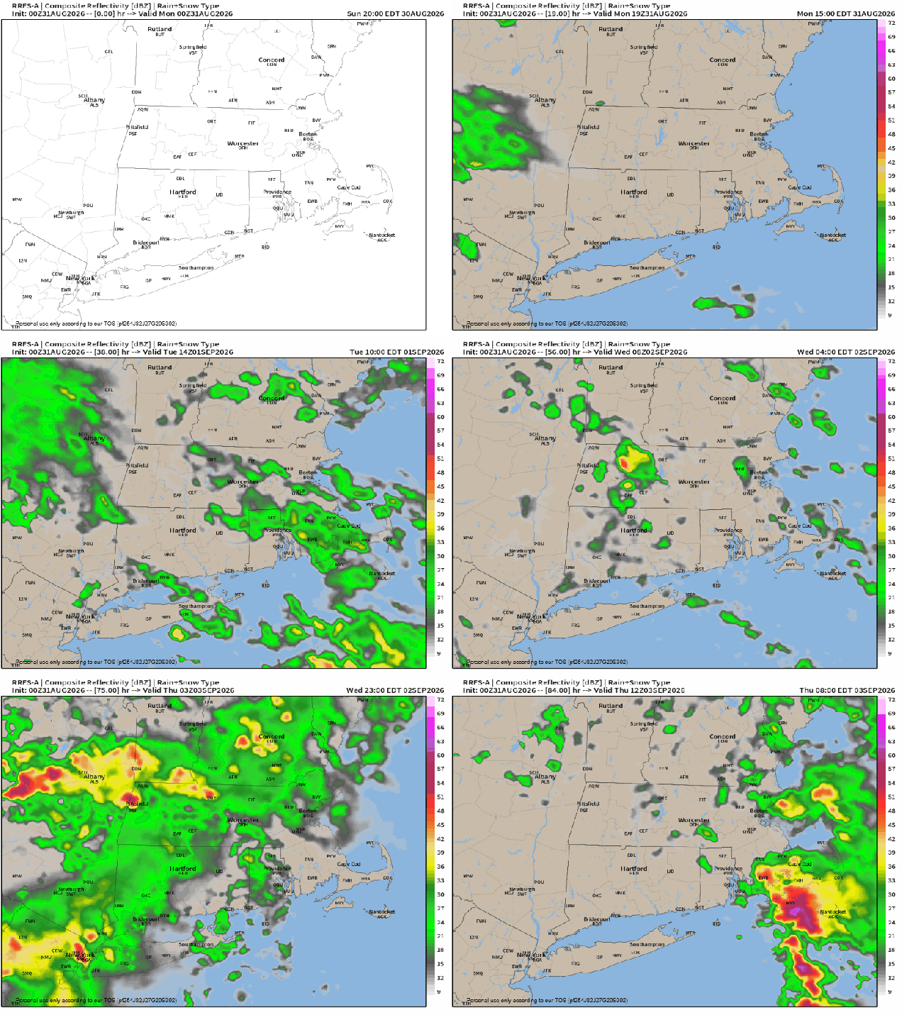
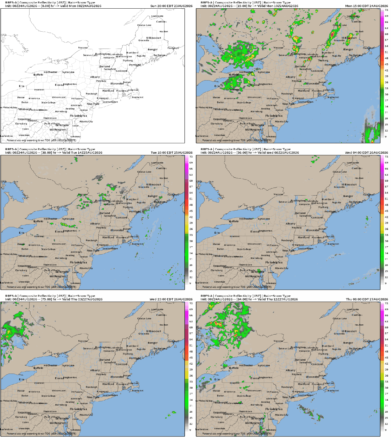
A backdoor cold front will drop southward today, likely stalling out just south and west of the region. The front will be accompanied by just a few clouds, but behind it, cooler air will settle in, especially near the east coast. A couple of waves of low pressure will ride along the front, keeping lots of clouds in place with some episodes of showers and a few thunderstorms at times between Monday night and Thursday. The last wave will lift the front northward as a warm front on Thursday, before a stronger cold front moves through late in the day, with some additional showers and thunderstorms. High pressure then builds in at the surface, but an upper-level low will settle into the Northeast for Friday and Saturday, possibly Sunday as well. The result will be sunshine each morning, some clouds build up, and a few spotty showers developing. For Labor Day, high pressure should result in dry and seasonably mild weather.
Several episodes of showers and thunderstorms are likely over the next few days. Loop provided by Weathermodels.com
Monday: A mix of sun and clouds. High 75-82, cooler near the east coast, especially in the afternoon.
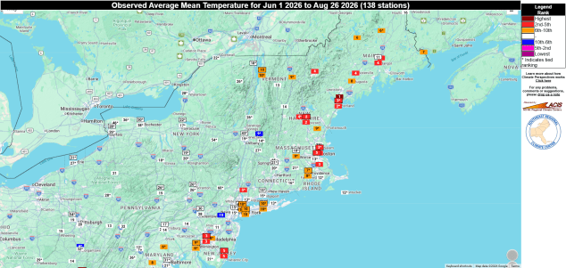
The last 4 days of meteorological summer are upon us, and for the most part they’ll be good.
For parts of eastern New England, this has been one of the warmest summers on record. Image provided by the Southeast Regional Climate Center.
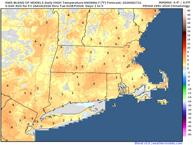
A frontal system will slowly move across the region over the next 24 hours. This system will produce showers and thunderstorms to our west through the evening, some of which could be strong to severe, but only a few widely scattered showers are expected across our area overnight. On Friday, we’ll see a few more showers and thunderstorms during the afternoon, but the bulk of the day should be dry. High pressure then builds in for the weekend with drier and seasonably warm conditions. As we get into Monday, a backdoor cold front will start dropping southward. Temperatures will depend on how quickly the front moves in, but only a few showers will accompany it, so most of the day should remain dry.
Temperatures will remain a little above normal for the next few days. Image provided by weathermodels.com
Thursday night: Partly to mostly cloudy with some widely scattered showers and areas of patchy fog. Low 64-71.
Friday: Partly sunny, a few showers and thunderstorms likely, mostly in the afternoon. High 78-85.
Friday night: Showers and storms end in the evening, becoming partly cloudy. Low 56-63.
Saturday: Partly to mostly sunny. High 74-81.
Saturday night: Clear to partly cloudy. Low 57-64.
Sunday: Sunshine and some afternoon clouds. High 78-85.
Sunday night: Partly cloudy. Low 61-68.
Monday: Intervals of clouds and sun with some showers likely. High 75-82.
Some unsettled weather is expected at times for the last full week of meteorological summer.
Temperatures will be a little below normal this week, especially across the interior. Image provided by WeatherBell.
The frontal system that brought us some showers over the past few days is finally pulling away, but an upper level low remains in place across southeastern Canada. This will generate some clouds and a few showers this afternoon, mainly north and west of Boston. Tuesday looks to be similar, though shower coverage will be a little less, as the upper low slowly starts to move away. High pressure builds in with drier weather for Wednesday into part of Thursday. Low pressure moving into southeastern Canada sends a warm front our way, with some showers during the afternoon and evening. A cold front trailing the system brings in more showers on Friday, then high pressure starts to build in for the weekend. Another upper-level low moves into southeastern Canada by late in the weekend, and a disturbance rotating around it may bring in a shower or two on Sunday.
An upper-level low will trigger some afternoon showers across the Northeast during the next few afternoons. Loop provided by weathermodels.com
Monday: For burns off revealing some morning sun, then some clouds develop with a few afternoon showers, mainly north and west of Boston, breezy. High 76-83.
Monday night: Mostly clear. Low 56-63.
Tuesday: Sunshine and some afternoon clouds, chance for a shower or two. High 74-81.
Tuesday night: Clear skies. Low 57-64.
Wednesday: A mix of sun and clouds. High 76-83.
Wednesday night: Partly cloudy. Low 59-66.
Thursday: Partly sunny, breezy, chance for some late-day showers or thunderstorms. High 78-85.
Thursday night: Partly to mostly cloudy, showers likely. Low 63-70.
Friday: Partly sunny, a few lingering showers in the morning across southeastern Massachusetts, then more showers during the afternoon. High 78-85.
Saturday: A mix of sun and clouds. High 76-83.
Sunday: Partly sunny, chance for an afternoon shower. High 76-83.
Some rain is on the way for parts of the weekend, but it won’t be a washout.
Episodes of showers and dry periods are likely through the weekend. Loop provided by weathermodels.com
A cold front will move across the region this evening and then stall out just to the south, controlling our weather for the next few days. Showers shower taper off this evening as the front settles south, but may continue across parts of the South Coast and Cape Cod into the night. High pressure will try to build in from the north on Friday with some drier air, but a wave of low pressure riding along the front to our south may bring in another period of showers to parts of Rhode Island and southeastern Massachusetts. As we get into the weekend, an upper-level low pressure area will settle into southeastern Canada. Disturbances rotating around it may help trigger additional waves of low pressure riding along the front. Another batch of showers will likely accompany one of those waves late Saturday and Saturday night. Sunday looks to be a day with some sun and occasional showers. Keep an eye to the sky (or radar) if you have outdoor plans. Much of the day should remain dry, but there will be some showers around. By Monday, high pressure starts building back in, but with the upper low nearby we’ll still have some clouds and maybe a shower or two.
Some heavier rainfall totals are possible south of Boston this weekend. Images provided by Pivotal Weather.
Thursday night: Plenty of clouds, some showers during the evening, possibly lingering into the overnight near the South Coast and Cape Cod. Low 59-66.
Friday: Some sunshine from the Merrimack Valley into southern New Hampshire, lots of clouds elsewhere, chance for a few showers across southeastern Massachusetts and Cape Cod. High 71-78.
Friday night: Mostly cloudy, chance for a shower or two across Cape Cod. Low 58-65.
Saturday: Plenty of clouds, showers likely, especially during the afternoon, mainly south of Boston. High 69-76.
Saturday night: Cloudy with more showers. Low 60-67.
Sunday: Clouds and some sunny breaks, some occasional showers possible. High 74-81.
Sunday night: Showers taper off in the evening, becoming partly cloudy. Low 60-67.
Monday: A mix of sun and clouds, chance for an afternoon shower. High 76-83.
The week is starting off damp, but much of it will be dry.
Temperatures should be in the upper 70s to lower 80s at this time of year. Image provided by weathermodels.com
Low pressure passing north of the region with a secondary area of low pressure passing south of the region will bring in some showers today, mostly during the morning, though occasional showers may linger into the afternoon. We’re not expecting widespread heavy rain, but it’ll be enough to make the morning commute a little slower, since a good chunk of the population around here seems to forget how to drive when the weather is not perfect, but we digress. High pressure starts to build in for Tuesday, but a weak upper-level disturbance may trigger a shower or two in the afternoon. Wednesday looks to be a dry day, but clouds will start moving in ahead of a cold front. That front will bring in another round of showers and thunderstorms on Thursday. That front will stall out offshore on Friday as high pressure tries to build in. The weekend is iffy at this point. An upper-level trough of low pressure will move in, while at the surface a couple of waves of low pressure will ride along that stalled out front. The result will likely be some clouds and more showers, especially near the South Coast. How far north those showers get remains to be seen, but this is something we’ll be keeping an eye on, and should have a better idea of by the time we get to our Weekend Outlook on Thursday.
Will Sunday be wet across the region? Time will tell. Images provided by Pivotal Weather.
Monday: Showers likely through the morning, tapering off and ending during the afternoon. High 70-77.
Monday night: Partly to mostly cloudy, areas of patchy fog develop. Low 63-70.
Tuesday: Becoming partly sunny, chance for an afternoon shower. High 75-82.
Tuesday night: Partly cloudy. Low 60-67.
Wednesday: Mostly sunny, clouds start to move in late in the day. High 79-86.
Wednesday night: Partly cloudy. Low 63-70.
Thursday: Partly sunny, scattered showers and thunderstorms likely. High 77-84.
Thursday night: Showers may linger near the South Coast, becoming partly cloudy elsewhere. Low 58-65.
Friday: A mix of sun and clouds. High 76-83.
Saturday: More clouds than sunshine, chance for a few showers, mainly near the South Coast. High 74-81.
Sunday: Intervals of clouds and sun, chance for a few showers. High 73-80.
Some fairly typical summertime weather continues for a few more days, but relief arrives at the end of the week.
Temperatures remain above normal for much of the work week. Image provided by Weathermodels.com
The cold front that moved through yesterday bringing some drier air into the region will lift back northward as a warm front today, allowing the humidity to return. As the humid air returns we could see a few showers and thunderstorms this evening, but they’ll be weakening as they move in from the west, and might not make it all the way to the coastline. Another weak cold front moves through early Tuesday, with sunshine and drier weather for Tuesday and Wednesday. It will be hazy at times as more high-level smoke from wildfires in the West drifts into the region. Thursday will see a stronger cold front move into the region. It’ll be warm and humid ahead of it, with more showers and thunderstorms likely. The timing of the front will be key in determining whether we get any severe weather. Right now, it looks like the front moves through by early afternoon, but if it were delayed by a few hours, allowing additional time for the atmosphere to become unstable, severe weather would become more likely. This is something we’ll be keeping an eye on for the next few days. Behind the front, cooler and drier air settles in for Friday and Saturday. We’ll be watching another system moving out of the Midwest that could bring in some showers and thunderstorms later on Sunday.
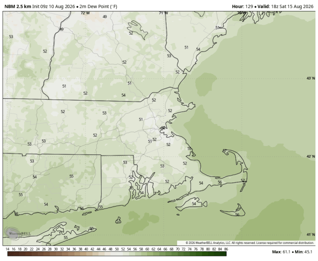
Dewpoints in the 50s on Saturday? Certainly looking that way. Image provided by WeatherBell.
Monday: Hazy sunshine in the morning, clouds start to move in by late afternoon. High 83-90.
Monday night: Chance for a shower or thunderstorm in the evening, partly cloudy overnight. Low 66-73.
Tuesday: Hazy sunshine and some afternoon clouds. High 82-89.
Tuesday night: Partly cloudy. Low 61-68.
Wednesday: Sunshine and some afternoon clouds. High 80-87.
Wednesday night: Partly cloudy. Low 62-69.
Thursday: A mix of sun and clouds, a few showers and thunderstorms likely. High 80-87.
Thursday night: Becoming clear. Low 60-67.
Friday: Mostly sunny, breezy, not as humid. High 78-85.
Saturday: Sunshine and a few clouds. High 74-81.
Sunday: Partly sunny, chance for late-day showers and thunderstorms. High 73-80.
El Nino has resulted in in a quiet start to hurricane season in the Atlantic, but things may be changing.
Several areas of interest are being monitored in the Atlantic and the Pacific. Image provided by PolarWx.
Atlantic Hurricane Season usually (but not always) features below normal activity in the Atlantic Ocean. The main reason for this is high-level wind shear, and that has been the case so far this season, especially across the Caribbean. In the tropics, trade winds resulting in most systems moving from east to west. Wind shear is when you have strong winds in the upper levels of the atmosphere blowing from west to east. As thunderstorms intensity, the strong winds in the upper levels essentially rip the tops off of them, so they cannot fully develop, and thus systems can’t get organized.
Wind shear across the tropical Atlantic is the second strongest on record this season. Image provided by Colorado State University.
The other issue that has caused a relative dearth of storms in the Atlantic has been Saharan Dust. Every year, strong winds blow plumes of dust and sand from the Sahara across the Atlantic and towards the Caribbean and the Gulf. These plumes contain very dry air, inhibiting the development of showers and thunderstorms, and produce very hazy conditions across the islands of the Caribbean. Normally these plumes begin to wane in intensity by mid-to-late July, but this year they have remained fairly strong into early August. Another fairly strong plume will move across the Greater Antilles over the next few days.
Plumes of Saharan dust continue to cross the Atlantic. Loop provided by weathermodels.com
Most forecasts, including the most recent update from the team at Colorado State University, continue to show the likelihood of a below-normal season. Thus far, there have only been two named storms in the Atlantic – both in the Gulf. Short-lived Tropical Storm Arthur along the Texas coast in mid-June, and Tropical Storm Bertha, which brough gusty winds and heavy rain from the Florida Panhandle to Louisiana in mid-July. On average, we should have had three named systems by now, with the third one forming around August 3, and the fourth named system of the season forming around August 15 on average. The first hurricane of the season forms around August 11 on average. In terms of Accumulated Cyclone Energy or ACE, which factors storm strength and duration, activity in the Atlantic is only about 22% of normal thus far.
Forecasts continue to show the likelihood of a below normal hurricane season in the Atlantic. Image provided by Colorado State University.
Tropical waves continue to roll off of the west coast of Africa every few days, and as they move into the Atlantic they encounter the Saharan dust and accompanying dry air, the strong wind shear, and water temperatures in the eastern Atlantic that aren’t warm enough to support a tropical system, but that may be changing. Water temperatures in the tropical Atlantic are now warm enough all the way to the coast of Africa to support a system. The last few waves that have moved into the Atlantic have been a bit more robust, with more widespread shower and thunderstorm activity. Forecast models are showing two areas that need to be watched in the Atlantic over the next week for development.
There are two disturbances that need to be monitored for development in the Atlantic over the next week. Image provided by the National Hurricane Center.
A tropical wave that moved off the west coast of Africa early Friday is now southwest of the Cabo Verde Islands and producing disorganized showers and thunderstorms. Conditions right now are marginally favorable for the system to get organized as it crosses the Atlantic. By the time it reaches the Lesser Antilles, wind shear will increase and conditions will quickly become hostile, eliminating any chance of further development. Another cluster of thunderstorms is moving off the west coast of Africa this evening, but it is farther north than most of the tropical waves, and will likely get choked off by Saharan dust fairly quickly.
Tropical waves continue to move across the Atlantic. Loop provided by Tropical Tidbits.
Another wave will move off of the west coast of Africa early next week. This wave is expected to be fairly robust, and will likely encounter a less hostile atmosphere as it moves into the Atlantic. Several forecast models have been indicating the possibility that this system could develop into at least a tropical depression, and possibly fairly quickly once it is over water. Of course, this is still days away, and until there is an actual storm for the models to initialize, it is all just speculation. It’s something we’ll continue to monitor for the next several days.
Many members of the ECMWF Ensemble show the potential for a tropical cyclone over the Atlantic next week. Loop provided by weathermodels.com
The Atlantic isn’t the only basin where things are getting active. There are three separate systems being monitored for development in the Eastern Pacific, once of which has a slight chance of impacting Hawaii later next week. In the Western Pacific, Typhoon Dolphin will make landfall in eastern China a few hundred miles south of Shanghai on Sunday. Tropical Storm Chan-Hom is expected to make landfall in Japan more than 100 miles north of Tokyo on Tuesday. Tropical Depression Kujira should become a tropical storm and pass a few hundred miles north of the Northern Marianna Islands late Sunday, and another system is expected to develop well northeast of the Northern Mariannas by early next week.
This is going to be one of the shortest and easiest to write forecasts we’ve ever done.
A Heat Advisory is in effect for most of the region into Friday. Image provided by the National Weather Service office in Norton, MA.
A Bermuda High will remain anchored off the East Coast through the weekend and into early next week. That will result in very warm to hot and humid conditions with a daily chance for showers and thunderstorms. It won’t be as hot as the heat wave we had in early July, but it will be quite humid, so the heat index will remain uncomfortable. We’re not expecting widespread severe weather, but some of the thunderstorms that pop up each afternoon could produce heavy downpours and gusty winds.
Dewpoints will remain in the upper 60s to middle 70s through much of the weekend. Loop provided by Weathermodels.com
Thursday night: Any showers or thunderstorms taper off and end during the evening, becoming clear to partly cloudy with areas of fog developing. Low 68-75.
Friday: Sunshine and some afternoon clouds with some late-day showers and thunderstorms popping up. High 86-93.
Friday night: Showers and thunderstorms end in the evening, becoming clear to partly cloudy. Low 68-75.
Saturday: Partly sunny, chance for some showers and thunderstorms during the afternoon. High 84-91.
Saturday night: Any showers or storms end in the evening mostly clear overnight. Low 67-74.
Sunday: Sunshine and a few clouds, slight chance for a late-day shower or thunderstorm. High 85-92.
Sunday night: Clear skies. Low 64-71.
Monday: A mix of sun and clouds, chance for an afternoon shower or thunderstorm. High 85-92.
Some typical summertime weather is expected for the first full week of the last month of meteorological summer.
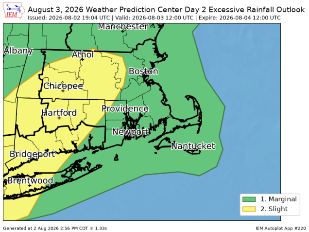
Heavy rainfall is possible across the interior today, with some flash flooding possible. Image provided by Iowa Environmental Mesonet.
The week starts off on a wet note with a cold front approaching the region. A warm and humid airmass will be in place with gusty southwest winds at times, especially across eastern Massachusetts. Showers and a few thunderstorms are likely through the morning, some of which could be locally heavy. Some pockets of flash flooding are possible, as the ground remains fairly saturated from recent rainfall, which has pretty much taken care of the drought. We’re still in a long-term rainfall deficit, but the drought itself is essentially gone. The showers will taper off, then we may see some sunny breaks develop. As the cold front moves in during the afternoon, it will trigger a second round of showers and thunderstorms. Depending on how much sun we get, some of those storms could become severe.
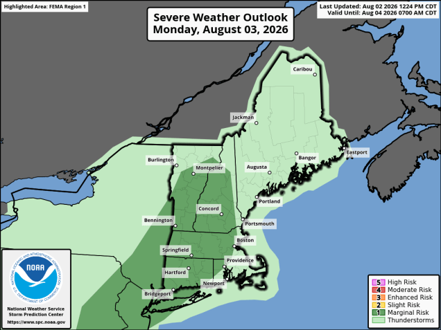
Severe weather is possible across the interior this afternoon. Image provided by the Storm Prediction Center.
The front moves offshore tonight then high pressure builds in with drier weather for Tuesday. High pressure then sets up residence off the East Coast, resulting in very warm to hot and humid weather from Wednesday through the weekend. As is typical of a warm and humid airmass in the summer, we’ll see a daily chance for pop-up showers and thunderstorms, especially towards the end of the week and into the weekend. Widespread severe weather is not expected, but any of these storms could produce heavy downpours and gusty winds.
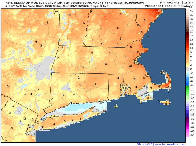
Above normal temperatures are expected for the end of the week and the weekend. Image provided by weathermodels.com
Monday: Morning showers and thunderstorms, some may produce heavy downpours, then some sunny breaks develop. Showers and thunderstorms redevelop in the afternoon, breezy, very humid. High 74-81.
Monday night: Showers and thunderstorms end in the evening, clearing overnight. Low 59-66.
Tuesday: Partly to mostly sunny, less humid. High 79-86.
Tuesday night: Partly cloudy. Low 59-66.
Wednesday: Partly sunny, chance for afternoon showers and thunderstorms. High 80-87.
Wednesday night: Partly cloudy. Low 64-71.
Thursday: A mix of sun and clouds, humid, chance for an afternoon shower or thunderstorm. High 83-90.
Thursday night: Clear to partly cloudy. Low 66-73.
Friday: Partly to mostly sunny, an afternoon shower or thunderstorm is possible. High 84-91.
Saturday: Partly sunny, chance for afternoon showers or thunderstorms. High 83-90.
Sunday: A mix of sun and clouds, chance for a shower or thunderstorm. High 84-91.