Weekend Outlook: April 30 – May 3, 2021

We’re stuck in a typical spring weather pattern for New England, which means that it’s not going to be sunny and warm for the most part, and probably won’t be for a while.

Temperatures are in the upper 40s and 50s north of a frontal boundary this afternoon, with 70s and 80s south of it. Image provided by Weathermodels.com

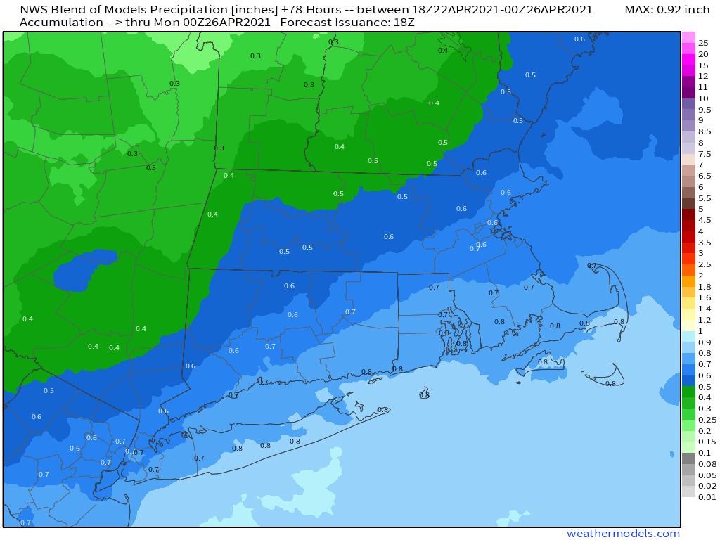
A wavy frontal boundary will be teasing us for the next several days while several waves of low pressure ride along it. South of that boundary, temperatures will be in the 70s and 80s, but north of it, only in the 50s and 60s. Unfortunately, that boundary is going to stay just to the south of our area for the most part. One wave rides along the front tonight, with periods of rain likely. The rain tapers off by Friday morning, and as the low pulls away. we may see some breaks of sunshine develop. As winds shift into the west and northwest behind the system, temperatures will actually warm up a bit, since the winds won’t be off the chilly Atlantic any longer. However, an upper-level low will be moving across the region, and it could help produce a few more showers Friday evening and night. With cooler air moving in, we could even see some wet snowflakes mix in, especially well inland and across some of the hills. High pressure will try to build in on Saturday with some sunshine along with gusty winds and cool temperatures.

Your lawn will appreciate the nice drink of water it will get over the next 18-24 hours. Image provided by WeatherBell.

On Sunday, that pesky front will try to lift back northward as a warm front. We’ll turn milder, but also have some clouds moving in with a few showers possible, mainly at night. The question becomes, how far northward does that warm front get on Monday? South of the front, temperatures will be well into the 60s and 70s, while north of it, temperatures will only be in the 50s, perhaps upper 40s. Right now, we’re leaning toward the colder side, because that is more typical of early May, but the warm air may settle in south of the Mass Pike. Some showers are also likely during the day, as low pressure slowly approaches from the west.

The models have differing opinions on how far northward the warm air gets on Monday. Images provided by Pivotal Weather.

Thursday night: Cloudy with periods of rain and showers likely. Low 44-51.

Friday: Showers end early, some sunny breaks may develop in the afternoon, becoming windy. High 61-68.

Friday night: Mostly cloudy and windy with scattered showers, possibly mixed with wet snow across the interior. Low 34-41.

Saturday: Becoming partly to mostly sunny, still breezy. High 56-63.

Saturday night: Clouds return. Low 39-46.

Sunday: More clouds than sunshine, breezy, and warmer. High 65-72.

Sunday night: Partly to mostly cloudy, chance for showers late at night. Low 44-51.

Monday: Cloudy with a chance of showers. High 58-65.

Weekly Outlook: April 26 – May 2, 2021

In our Weekend Outlook, we mentioned the potential for a significant warmup later this week. Well, that was a bit premature.

We start the week off with high pressure building in behind yesterday’s storm system. We’ll still have breezy conditions in the wake of the system, especially during the morning and early afternoon. With an upper-level low pressure area also moving across the Northeast, some clouds may pop up during the afternoon as well. As the upper low pulls away on Tuesday we’ll have some sunshine, less wind, and milder temperatures.

Wind gusts of 30 mph or higher are possible today. Image provided by WeatherBell.

A warm front moves into the region late Tuesday night, with some showers and possibly a thunderstorm accompanying it. This sets up a very mild day on Wednesday, with much of the region getting well into the 70s, and some 80-degree readings possible well inland. The warmth won’t last long though, as a cold front will be approaching the region later in the day, producing another round of showers and possibly thunderstorms.

Wednesday looks like it will be the warmest day of the week. Image provided by Weathermodels.com

After that, things get a little complicated, as the models don’t agree on exactly how the pattern evolves. That cold front stalls out near or just south of the region Wednesday night. Another wave of low pressure rides along that front, bringing in another round of showers on Thursday. Will that wave lift the front back through as a warm front or not? That’s a critical question for the temperature forecast. The showers look like they will linger into Friday with mild temperatures before a stronger cold front moves through late in the day. Saturday looks to be drier and cooler with high pressure building in, but another upper-level low moves through, with more clouds and possibly a shower or two. Sunday looks milder as high pressure moves offshore and a southwesterly flow redevelops. However, another system could be approaching the region from the west. Whether the shower activity ahead of that system arrives late in the day Sunday or on Monday is a detail that can’t be resolved this far out.

Temperatures on Thursday will be highly dependent on where the front is located. Images provided by Pivotal Weather.

Monday: Partly to mostly sunny and breezy. High 53-60.

Monday night: Partly cloudy. Low 34-41.

Tuesday: A mix of sun and clouds. High 63-70.

Tuesday night: Partly to mostly cloudy with a few showers possible, maybe even a rumble of thunder. Low 43-50.

Wednesday: Intervals of clouds and sunshine, showers and thunderstorms possible late in the day and into the evening. High 69-76, cooler along the coast.

Thursday: Plenty of clouds with showers likely. High 56-63.

Friday: Mostly cloudy and breezy with more showers. High 59-66.

Saturday: Partly sunny. High 56-63.

Sunday: A mix of sun and clouds, breezy, chance for a few late-day showers. High 57-64.

Weekend Outlook: April 23-26, 2021

After today’s chill and flurries, some milder weather is on the way. So is some rain for part of the weekend.

Another chilly night is expected tonight as high pressure builds in. That high will move offshore on Friday, allowing temperatures to start to moderate under mostly sunny skies. Saturday looks even milder, with temperatures possibly topping 70 in some areas, but the sunshine will start to fade as clouds begin to stream into the region. Those clouds will be in advance of a low pressure system that will move up the East Coast Saturday night and Sunday, bringing in some much-needed rain. While we do need the rain, Sunday looks like a damp and cool day, so any of your outdoor plans probably won’t work out. The system pulls away late Sunday, then Monday looks to feature more sunshine and seasonably mild temperatures. There are some indications that a more significant and possibly longer-lasting warmup could be in store for the latter half of next week and into next weekend.

You may not like the rain on Sunday, but your lawn will. Image provided by Weathermodels.com

Thursday night: Clear skies, breezy, and chilly. Low 29-36.

Friday: Mostly sunny, breezy, and milder. High 54-61.

Friday night: Clear skies. Low 37-44.

Saturday: Sunshine in the morning, clouds start to stream in during the afternoon. High 64-71.

Saturday night: Becoming cloudy with rain developing after midnight. Low 41-48.

Sunday: Periods of rain, breezy. High 51-58.

Sunday night: Any lingering showers end in the evening, followed by gradual clearing. Low 35-42.

Monday: Becoming partly to mostly sunny. High 55-62.

Weekly Outlook: April 19-25, 2021

It’s Patriots Day in Massachusetts, and although the Marathon won’t be held until October, there’s still plenty going on today, and the weather should cooperate for the most part.

The day will start off with some sunshine and seasonably mild temperatures, but an upper-level disturbance will cross the Northeast today, allowing for some clouds, and probably a few showers, maybe even a thunderstorm, this afternoon. They shouldn’t be widespread, nor heavy, but given that we still have a significant rainfall deficit, every little bit helps. A cold front will move through on Tuesday, but with little fanfare aside from some clouds and possibly a shower or two. Ahead of it, temperatures will be quite mild, possibly topping 70 in some locations. That front will stall out near or just south of the South Coast Tuesday night, then lift back northward as a warm front on Wednesday as low pressure passes north and west of the region. With low pressure to our northwest, it’ll be quite mild again, but another cold front will approach from the west, producing another round of showers and thunderstorms.

Temperatures could reach 70 in many areas on Tuesday. Image provided by WeatherBell.

Behind that front, high pressure builds in with much cooler conditions on Thursday and to a lesser extent on Friday. A few weak upper-level disturbances will also be moving through with some clouds at times, but little precipitation other than a stray shower. Next weekend looks unsettled, but the details are still a little fuzzy. A period of rain or showers and cool temperatures appears likely at some point, but will it be late Saturday and Saturday night as one model shows, or on Sunday as a different one indicates? We should have a better handle on that when we do our Weekend Outlook on Thursday.

Year-to-date rainfall totals are running 4-6 inches below normal across much of the region. Image provided by the Northeast Regional Climate Center.

Monday: Early sun, then clouds develop, with a few showers or thunderstorms possible in the afternoon. High 61-68, coolest along the coast.

Monday night: Clear to partly cloudy. Low 38-45.

Tuesday: A mix of sun and clouds, breezy, just a slight chance for a late-day shower. High 64-71.

Tuesday night: Partly cloudy. Low 41-48.

Wednesday: Becoming mostly cloudy and breezy with showers likely, possibly a thunderstorm, ending in the evening. High 59-66.

Thursday: Plenty of clouds with a slight chance for a shower, windy and much cooler. High 43-50.

Friday: Intervals of clouds and sunshine, breezy. High 53-60.

Saturday: Early sun, then clouds return with showers possible late in the day and at night. High 60-67.

Sunday: Cloudy with a chance of rain. High 53-60.

Weekend Outlook: April 16-19, 2021

It’s not April 1, and this isn’t a joke – there’s snow in forecast for parts of our area.

Low pressure is moving off the Mid-Atlantic coast this afternoon while an upper-level low pressure area moves in from the west. The upper-level low will draw the surface low northward towards southeastern New England while it intensifies. Rain is spreading across the region this afternoon, and it will become steadier and heavier tonight as the low moves up the coast. With the upper-level low moving in, we’ll have some very cold air aloft. As the rain becomes heavier, it will pull the cold air down from above, a process called “dynamic cooling”. As this occurs Friday morning, we’ll see the rain change over to snow across the hills from northwestern Rhode Island and central Massachusetts into southwestern New Hampshire. Some wet snow may mix in across the lower elevations of southern New Hampshire and northern Massachusetts as well but we’re not expecting much, if any, accumulation, and what does accumulate will be mainly on grassy surfaces because the pavement is too warm, and air temperatures won’t drop below freezing. It’ll be a different story across the hills from Worcester County into the Monadnocks of southwestern New Hampshire, where several inches may accumulate. Even heavier snow is possible for the Berkshires and the Green Mountains of Vermont. We should note that there are some models that are forecasting accumulating snow, and in some cases quite a bit of it, across most of eastern Massachusetts and Rhode Island. While we can’t completely rule out this scenario, we’re not expecting it to occur.

Most of us won’t see much, if any, snow from this system. Image provided by WeatherBell.

The surface low will pass near or over Cape Cod or southeastern Massachusetts Friday afternoon, allowing any mixed precipitation to change back to all rain and milder air moves in. The rain will taper off to showers in the afternoon, but the showers may not completely end until early Saturday as the system slowly starts to move away. Given the recent lack of rainfall, we’re starting to see drought conditions develop. With 1-2 inches of rain expected from this storm, we’ll help put a nice dent in that developing drought.

Much-needed rain is expected over the next 48 hours. Image provided by Weathermodels.com

Saturday won’t be quite as chilly as Friday, but we probably won’t see much sunshine either as the system only slowly moves away. High pressure starts to build in on Sunday with more clearing and milder temperatures. However, an upper-level disturbance will be moving through, so a couple of pop-up showers can’t be ruled out. Patriots Day on Monday is shaping up to be a nice Spring day with partly sunny skies and mild temperatures, but again, a pop-up shower can’t be ruled out as another weak upper-level disturbance crosses the region.

Monday looks to be a mild day. Image provided by WeatherBell.

Thursday night: Periods of rain, possibly heavy at times, changing to snow across the hills from northwestern Rhode Island and central Massachusetts into southwestern New Hampshire, breezy. Low 33-40.

Friday: Windy with rain mixed with snow at times in the morning, tapering off to showers during the afternoon. High 37-44, possibly a little warmer south of Boston.

Friday night: Cloudy and breezy with showers ending. Low 33-40.

Saturday: Plenty of clouds, possibly a few showers near the coast, some sunny breaks may develop in the afternoon. High 44-51.

Saturday night: Partly to mostly cloudy. Low 32-39.

Sunday: Intervals of clouds and sunshine, slight chance for a shower. High 49-56.

Sunday night: Clear to partly cloudy. Low 33-40.

Monday: Partly sunny, slight chance for a shower. High 56-63.

Weekly Outlook: April 12-18, 2021

One of our colleagues called the current weather pattern a “quiet active pattern”, which is a very good way to describe the week ahead.

In the big picture, we’ve got an upper-level low pressure area in place for today into Tuesday before it moves out, but another one moves in for the end of the week and the start of the weekend. Looking a little closer, we’ve got some typical April weather, but since this is New England and not Florida, a lot of you probably won’t like it. Low pressure passes south of the region today into early Tuesday, with plenty of clouds around and a chilly east wind off the Atlantic. Some showers are possible, mainly today, but we’re not looking at widespread rainfall. Wednesday looks a little drier as high pressure tries to build in with some partial sunshine and mild temperatures.

Temperatures will average close to normal around here over the next week. Image provided by WeatherBell.

The end of the week isn’t looking pretty at this point. As that second upper-level low pressure area moves eastward on Thursday, a low pressure area will likely spin up at the surface near the Mid-Atlantic coastline. As it gets caught up under the upper-level low, it will meander around near or just south of New England. The result will be chilly conditions, some gusty winds at times, and periods of rain from later Thursday into Saturday. But that’s not the entire story. With colder air aloft, we could see the rain change over to snow, with some accumulation in the higher terrain, such as the hills from northwestern Rhode Island into Worcester County and the Monadnocks of southwestern New Hampshire. Could we see snow mix in at lower elevations? Sure, it’s possibility, but accumulations aren’t likely (though not impossible). Remember, it was this same weekend last year (April 17-18), when we had a storm drop 3-6″ of snow on the hills, with up to an inch of snow across the rest of eastern Massachusetts and Rhode Island. We’ll obviously have a better handle on this situation when we do our Weekend Outlook on Thursday.

Models are showing the potential for snow, especially in the hills, at the end of the week. Images provided by Pivotal Weather.

Once the system pulls away, conditions will slowly improve over the weekend as high pressure starts to build in.

Monday: Cloudy and breezy with a few showers possible. High 44-51.

Monday night: Partly to mostly cloudy. Low 35-42.

Tuesday: Plenty of clouds with a few sunny breaks. High 52-59, cooler along the coast.

Tuesday night: Mostly cloudy. Low 37-44.

Wednesday: Intervals of clouds and sunshine. High 54-61, cooler along the coast.

Thursday: Cloudy and breezy with showers developing, possibly changing to snow in the hills at night. High 49-56.

Friday: Windy with periods of rain, possibly mixed with snow at times, especially in the hills. High 35-42 north and west of Boston, 43-50 south of Boston.

Saturday: Cloudy with showers gradually ending. High 47-54.

Sunday: Partly sunny. High 54-61, cooler along the coast.

Weekend Outlook: April 9-12, 2021

We’re still under the influence of a blocking pattern, which means that changes in our weather will be slow to take place, but there are changes coming.

Right now, we’re on the “good side” on the block, with high pressure in place. That will give us dry and mild to warm conditions through Saturday. Seabreezes will keep coastal areas much cooler, since ocean temperatures are still in the 40s, but away from the coast, temperatures will get well into the 60s and 70s for the next few days.

Saturday is shaping up to be a fantastic day. Image provided by WeatherBell.

As everything slides eastward. changes occur later in the weekend. We’ll see clouds start streaming in late Saturday and Saturday night as low pressure starts to move out of the Midwest. Some rain will move in ahead of the system on Sunday, though the day itself probably won’t be a washout. The main storm system will remain in the Midwest, but a secondary area of low pressure will develop and pass south of New England Sunday night and Monday, with some additional showers possible.

We’re not in a drought yet, but we do need some rain. Image provided by the National Drought Mitigation Center.

With the cloudcover and shower activity, it goes without saying that Sunday and especially Monday should be significantly cooler than Friday and Saturday, though Sunday is a bit of a wild card. Most of the models have a backdoor cold front move through around daybreak on Sunday, which results in a chilly day with east winds and temperatures holding steady in the 40s to lower 50s. There is one exception though. The Canadian model (full disclaimer: It’s not usually a good model), delays that backdoor cold front until mid-afternoon Sunday. While this isn’t much of a change in timing, it has a significant effect on the forecast. Instead of temperatures in the 40s and lower 50s, it has temperatures in the lower to middle 70s on Sunday ahead of the front, but then they quickly plunge into the 40s during the afternoon as the front moves through. For now, this is an outlier, but given the pattern that we’re in, a delay of 6-12 hours isn’t that far-fetched. With that in mind, we’re going to lean a little warmer than most of the models for Sunday (for now). If the rest of them are correct, then our forecast is too warm. If the Canadian model is right, then our forecast could be as much as 10-20 degrees too cool.

Most of the models, except for the Canadian and Regional Canadian model, are forecasting a chilly day on Sunday. Images provided by Pivotal Weather.

Thursday night: Clear to partly cloudy. Low 37-44.

Friday: Sunshine and a few clouds. High 64-71, cooler along the coast.

Friday night: Partly cloudy. Low 40-47.

Saturday: Partly sunny. High 66-73, cooler along the coast.

Saturday night: Mostly cloudy. Low 43-50.

Sunday: Cloudy with showers likely. High 54-61.

Sunday night: Mostly cloudy with a few showers possible. Low 36-43.

Monday: Cloudy with a chance of showers. High 51-58.

Weekly Outlook: April 5-11, 2021

Much of this week will feature conditions that are fairly typical for April in New England. That’s good if you live away from the coastline. Near the coast? No so much.

Low pressure south of Nova Scotia was sending clouds into eastern New England early this morning. Loop provided by NOAA.

The week starts off with low pressure off to the east slowly drifting southward. This will keep clouds in place across eastern New England with a few showers possible. We’ll also have northeast winds blowing off the still-chilly Atlantic, resulting in cool temperatures. The farther inland you head, the more likely you are to see sunshine and temperatures that are warmer than normal. Tuesday looks somewhat similar, but as the low pulls away, the small chance for showers we have today goes with it. High pressure then builds in for Wednesday through Friday with sunshine for much of the region along with seasonably mild temperatures.

Drought conditions are starting to develop across parts of the Northeast once again, so we need some rain. Image provided by the National Drought Mitigation Center.

Next weekend is where things get tricky again. High pressure will slide offshore on Friday as low pressure starts to approach from the southwest. For the weekend, there are some models that show the high remaining in place, keeping the region dry, but trending cooler. Other models have the rain from the system moving in, resulting in a damp and cool weekend. We’re going to lean on the dry side for now with the forecast, but obviously, the other scenario is just as plausible, so this is a low-confidence forecast. We should have a much better idea by the time we get to our weekend outlook on Thursday.

Will it rain this weekend? Some models say yes, some say no. Image provided by Weathermodels.com

Monday: Intervals of clouds and sunshine, breezy, chance for a few showers along the coast. High 53-60, a little cooler along the coast.

Monday night: Partly to mostly cloudy. Low 35-42.

Tuesday: Partly sunny. High 52-59, a little cooler along the coast.

Tuesday night: Partly cloudy. Low 35-42.

Wednesday: A mix of sun and clouds. High 49-56 along the coast, 57-64 inland.

Thursday: Partly to mostly sunny. High 48-55 along the coast, 56-63 inland.

Friday: Partly to mostly sunny. High 49-56 along the coast, 57-64 inland.

Saturday: Mostly sunny. High 52-59, a little cooler along the coast.

Sunday: Sunshine and a few clouds. High 51-58, a little cooler along the coast.

Weekend Outlook: April 2-5, 2021

We’ve got a fairly nice weekend coming up weather-wise, and a second crack at Opening Day after it was rained out today.

Low pressure will pull away from the region tonight, but an upper-level low pressure system will settle into the Northeast for Friday. So, even though we’ll start to clear out late tonight, clouds will come back on Friday. It will also be quite chilly by early April standards. While we’re not expecting any record lows, temperatures won’t be that far off from the records Friday night. High pressure then builds in for the weekend and into Monday, with dry and milder conditions. The only exception for now will be Sunday. An upper-level disturbance will move across the region, with some clouds and possibly a sprinkle or two.

Average highs in early April should be in the lower to middle 50s.

There is one potential fly in the ointment. The upper-level low that moves across the region on Friday will settle into Atlantic Canada this weekend and early next week. This will help to setup a blocking pattern in the atmosphere. At some point early next week, that upper low will drift westward, sending some clouds and perhaps some rain into the region. Right now, it looks like that may not happen until Monday night and Tuesday, but if it happens a little quicker than anticipated, Monday may not be a great day.

The models keep the rain on Monday to our east for now. Images provided by Pivotal Weather.

As for Fenway tomorrow for Opening Day – it won’t be the nicest of days, but it will be better than today. For first pitch at 2:10pm, skies should be partly sunny, winds will be out of the northwest at 5-10 mph, and temperatures should be around 40.

Thursday night: A lingering rain or snow shower this evening, then becoming clear to partly cloudy. Low 25-32.

Friday: Early sun, then clouds return. High 40-47.

Friday night: Clear to partly cloudy. Low 23-30.

Saturday: Mostly sunny. High 48-55.

Saturday night: Clear during the evening, some clouds move in overnight. Low 28-35.

Sunday: Intervals of clouds and sun, slight chance for a sprinkle. High 50-57.

Sunday night: Clear to partly cloudy. Low 33-40.

Monday: A mix of sun and clouds, breezy. High 52-59.