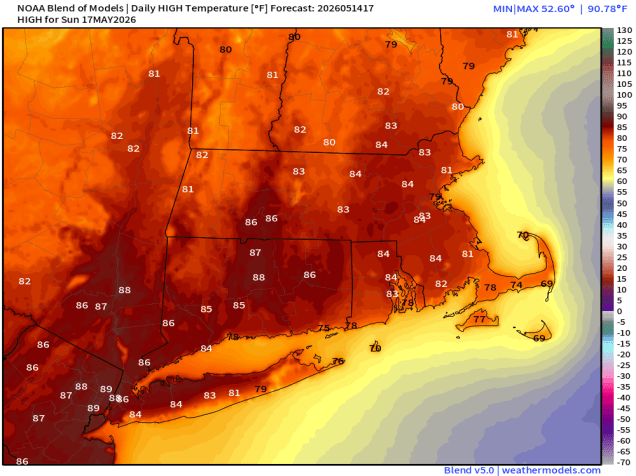
Hot and humid weather will make a brief return, but most of the weekend looks rather nice.
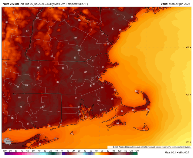
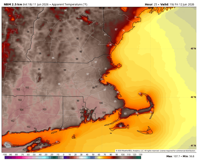
It will feel like it is in the 90s across most of the region Thursday afternoon. Image provided by WeatherBell.
High pressure sitting offshore has brought high humidity back to the region along with very warm to hot conditions, but it won’t last too long. A cold front will cross the region on Friday, with showers and thunderstorms ahead of it during the afternoon and evening. We’re not expecting widespread severe weather but some of the storms could produce heavy rainfall and gusty winds. The front pushes offshore Friday night, though it could linger near the South Coast for a while, keeping some clouds and possibly a few showers into early Saturday, otherwise, high pressure builds back in with lower humidity and seasonable warm conditions for the rest of the weekend and Monday.
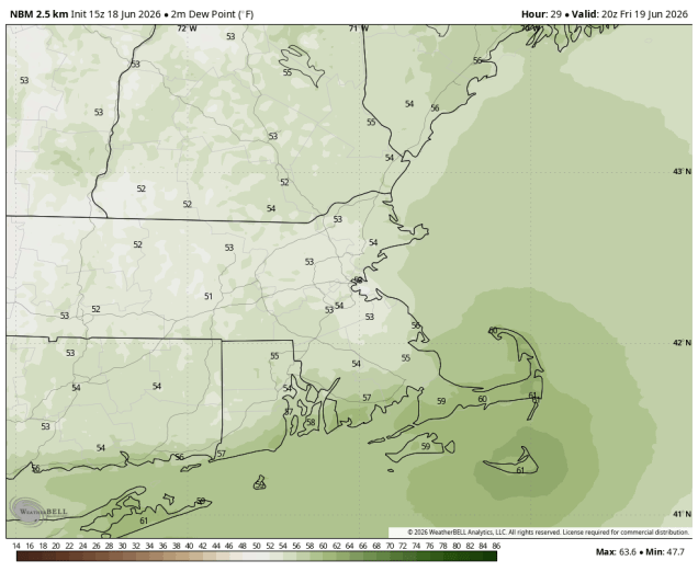
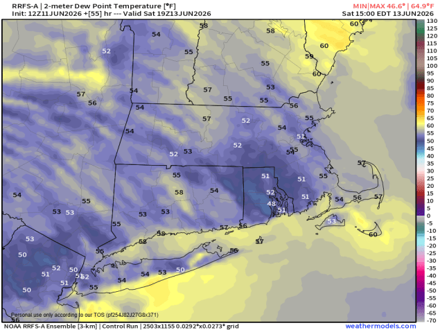
Dewpoints will drop into the 50s behind the front on Saturday. Image provided by Weathermodels.com
Thursday night: Any showers end this evening, partly to mostly cloudy with patchy fog overnight. Low 66-73.
Friday: A mix of sun and clouds, showers and thunderstorms develop in the afternoon. High 82-89.
Friday night: Showers and thunderstorms taper off and end, becoming partly cloudy across southern New Hampshire and northern Massachusetts. Low 63-70.
Saturday: Becoming partly to mostly sunny, less humid. High 77-84, a little cooler across Cape Cod.
As we get ready to celebrate America’s 250th, some very hot weather will be here for a few days.
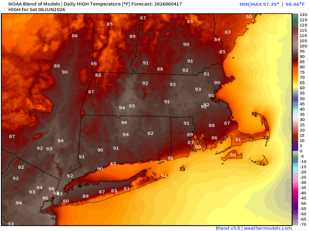
Friday will be another hot day before relief starts moving in on Saturday. Image provided by weathermodels.com
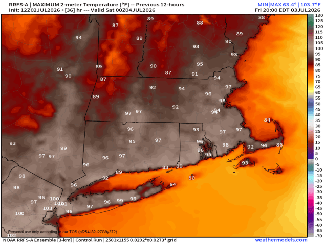
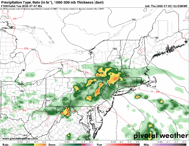
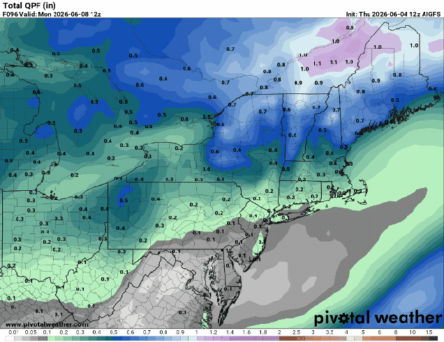
A ridge of high pressure continues to provide the eastern half of the nation with hot and humid conditions into Saturday. Daytime temperatures well into the 90s, combined with dewpoints in the 60s and lower 70s, will make it feel like 100-105 at times. Not much relief comes at night, with lows only in the 70s tonight through Friday night, with places like downtown Boston possibly not falling below 80. A few widely scattered showers and thunderstorms are possible tonight, but they’ll be a bit more numerous Friday afternoon and evening. The Fourth of July is the transition day, and unfortunately, with plenty of outdoor gatherings planned, they could be impacted. A cold front will drop southward, but ahead of it, we’re going to have another hot and humid day, with most places topping 90 again. However, the front will trigger some showers and thunderstorms, especially during the afternoon. Some of these storms may produce heavy downpours and gusty winds, so keep an eye to the sky (or the radar) if you’ll be outside. Hopefully the storms will end before evening, allowing many fireworks celebrations to proceed. Welcome relief arrives on Sunday with cooler and drier air. Cool is a relative term, and most places will still be in the 80s, which is right around or a little above normal. Monday is the day with the most uncertainty at this point. That front will stall out south of New England, and as we get to Monday a wave of low pressure will ride along it. Some models bring in some showers with the wave during the afternoon, some wait until nighttime. We’re going to be cautiously optimistic that most if the day remains dry at this point, but that is far from guaranteed.
Will the rain arrive Monday afternoon or wait until nightfall? Images provided by Pivotal Weather.
Thursday night: Mostly clear, slight chance for a shower or thunderstorm during the evening. Low 72-79.
Friday: Sunshine and a few clouds, a late-day shower or thunderstorm is possible. High 93-100, cooler across Cape Cod.
Friday night: Partly cloudy, chance for a few showers or thunderstorms, mainly before midnight. Low 72-79.
Fourth of July: A mix of sun and clouds, scattered showers and thunderstorms develop, mainly in the afternoon. High 89-96.
Saturday night: Any showers or storms end in the evening, clear to partly cloudy overnight. Low 65-72.
Sunday: Partly sunny, not as humid. High 81-88, cooler near the coast.
Sunday night: Partly cloudy. Low 60-67.
Monday: Intervals of clouds and sun, chance for showers late in the day. High 72-79.
The first full weekend of summer will feature some nice weather for part, but not all of the weekend.
Showers and storms are likely tonight, possibly Friday afternoon, and again Saturday morning. Loop provided by weathermodels.com
Low pressure heading into southeastern Canada will send a warm front our way tonight. Clouds will thicken up ahead of it with some showers and thunderstorms likely overnight and into Friday morning as the front moves through. Warm and humid air then moves in for Friday, but how much sunshine we’ll see is a question and that has a big impact on the forecast. Obviously more sunshine will lead to warmer temperatures, but with a cold front approaching later in the day, we’ll have the potential for some severe weather. The more sunshine, the higher the risk. The biggest threats with any storms will be damaging winds, hail, and heavy downpours. We need all the rain we can get to help with the ongoing drought, but too much in a short period of time will result in flooding, as we saw in Fall River a few days ago.
Some severe thunderstorms are possible on Friday. Image provided by the Storm Prediction Center.
The front will slow down as it pushes offshore Friday night and another wave of low pressure will ride along it, bringing some showers to parts of Rhode Island and southeastern Massachusetts Saturday morning. They could get as far north as Route 44, but this is uncertain at this point. We should see clearing from northwest to southeast in the afternoon. High pressure builds in with drier weather for Sunday and Monday, though we could see a few popup showers or thunderstorms Sunday afternoon with an upper level disturbance moving across the Northeast.
Monday will be the warmest day of the next few. Image provided by WeatherBell.
Thursday night: Becoming mostly cloudy with showers and thunderstorms developing after midnight. Low 58-65.
Friday: Showers end in the morning, then intervals of clouds and sunshine with a chance for more showers and thunderstorms, some possibly strong to severe, late in the day. High 74-81.
Friday night: Mostly cloudy, any lingering showers end in the evening. Low 60-67.
Saturday: Morning clouds with showers across parts of Rhode Island and southeastern Massachusetts, then skies start to clear out from northwest to southeast. High 73-80.
Astronomical summer starts at 4:24am on Sunday, and we’ll start things off with some rather nice weather.
Dewpoints will drop into the 50s on Friday. Image provided by WeatherBell.
Any lingering showers or thunderstorms will come to an end this evening as a cold front pushes offshore, with gradual clearing tonight. High pressure builds in for Friday with sunshine and lower humidity, but we’ll still have some clouds around with an upper-level disturbance nearby. We’ll have some gusty winds behind the front Friday, but they’ll start to diminish on Saturday, with more sunshine and low humidity. Sunday is the transition day, as another low pressure system heads our way. Most of the day will be dry and warm, but clouds will be streaming in ahead of the system, and humidity levels will slowly start to rise again. We could see a few late-day showers, but it looks like most of the rain will hold off until Monday. With the drought continuing to get worse, we need all the rain we can get. Many of the forecast models show the system on Monday bringing in some widespread rainfall, potentially heavy. However, we’ve seen this several times over the past few months. All of the models show a good soaking rain coming in, giving us some drought relief, and by the time the system gets here, the heavy rain either goes into Northern New England or across the Mid-Atlantic states, and around here we just end up with some scattered showers. We’ve mentioned a few times the old saying – “When in drought, leave it out”, so we’re skeptical that we’re going to get the widespread rains the models are forecasting. Until it actually happens, we need to see it to believe it.
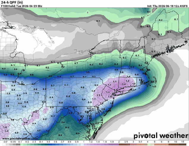
Many models show the potential for some heavy rain for at least parts of the region on Monday. Images provided by Pivotal Weather.
Thursday night: Showers and thunderstorms end in the evening, becoming clear to partly cloudy overnight. Low 59-66.
Friday: A mix of sun and clouds, breezy, less humid. High 76-83.
Friday night: Clear skies. Low 58-65.
Saturday: Sunshine and some afternoon clouds, still breezy. High 75-82.
Saturday night: Clear to partly cloudy. Low 56-63.
Sunday: Mostly sunny to start, some clouds start to filter in, chance for a late-day shower. High 76-83.
Sunday night: Becoming partly to mostly cloudy. Low 56-63.
Very warm to hot weather will continue through the weekend, but the humidity won’t.
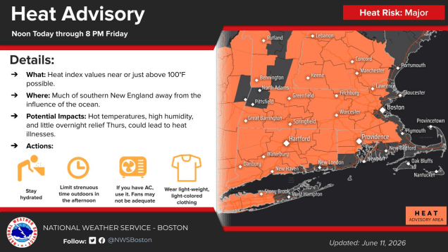
A heat advisory is in effect for much of the region away from the coastline through Friday evening. Image provided by the National Weather Service office in Norton, MA.
High pressure anchored off the East Coast will continue to pump hot and humid air into the region on southwest winds for another day or so, but some relief is on the way. A few showers and thunderstorms are possible through the evening, but they should gradually dissipate, leaving us with a warm and muggy night. Friday will also be hot and humid for most of the region, but a backdoor cold front will slip down the coast, bringing relief to coastal portions of Maine and New Hampshire, as well as the North Shore and likely the Boston area by midday. It probably won’t get too far inland, and may not get to the South Shore, but behind that front, temperatures will be in the 70s and lower 80s, compared to upper 80s and lower 90s inland. The South Coast and Cape Cod will be cooler as well, with southwest winds acting as a seabreeze. There could be a few widely scattered showers and thunderstorms in the afternoon, but most of the region will remain dry.
It’ll feel like the mid-to-upper 90s for much of the region Friday afternoon. Image provided by WeatherBell.
A stronger cold front moves in from the west Friday night, producing a few more showers and thunderstorms overnight. Behind that front we’ll clear out on Saturday. It will remain quite warm, with most places getting well into the 80s, but humidity levels will be much lower. Some clouds will start to filter back in on Sunday as another front moves toward the region, but again, most of the day will be dry and very warm. That front may produce a few showers and thunderstorms Sunday night, then we’ll see drier and cooler weather return for Monday.
Dewpoints will drop into the 50s behind a cold front on Saturday. Image provided by Weathermodels.com
Thursday night: Partly cloudy, any showers and thunderstorms taper off and end during the evening. Low 65-72.
Friday: A mix of sun and clouds, chance for a widely scattered shower or thunderstorm in the afternoon. High 86-93, cooler across the South Coast and Cape Cod. Coastal areas from Boston northward may turn cooler in the afternoon.
Friday night: Partly cloudy with a few showers and thunderstorms expected, skies start to clear out late at night. Low 63-70.
Saturday: Sun, sun, and more sun, much less humid. High 84-91, cooler across Cape Cod.
Saturday night: Clear to partly cloudy. Low 61-68.
Sunday: Sunshine slowly fades behind increasing clouds, breezy. High 85-92, cooler across Cape Cod.
Sunday night: Partly to mostly cloudy with a few showers and thunderstorms. Low 60-67.
The weekend will start with heat and humidity, but that won’t last the entire weekend.
If we get enough sunshine, Saturday could be quite toasty inland. Image provided by Weathermodels.com
High pressure building in south of the region will result in increasing heat and humidity for Friday and Saturday. While we’ll have a few clouds around during the day on Friday, they’ll become more widespread on Saturday as a cold front begins dropping southward from Canada. A shower or thunderstorm is possible Saturday afternoon, but most of the activity should stay well north and west of our area. Showers and thunderstorms should become more widespread Saturday evening and night. A wave of low pressure will ride along the front on Sunday, bringing in more showers with much cooler temperatures, especially near the coast. We’re not expecting a soaking rain, but any rain we get will help with the ongoing drought. Unfortunately, the rain will fall on Sunday, so it will lead to a lot of complaints about another rainy weekend, despite the fact that most of Saturday will be dry. High pressure builds in for Monday with drier weather along with seasonably mild conditions.
Most of the models aren’t forecasting heavy rain for Saturday night and Sunday. Images provided by Pivotal Weather.
Thursday night: Clear to partly cloudy. Low 55-62.
Friday: Sunshine with some afternoon clouds. High 83-90, cooler across Cape Cod.
Friday night: Partly cloudy. Low 59-66.
Saturday: Partly sunny, breezy, becoming humid, slight chance for a late-day shower or thunderstorm. High 85-92, cooler near the South Coast and Cape Cod.
Saturday night: Mostly cloudy with showers developing, possibly a thunderstorm. Low 60-67.
Sunday: Plenty of clouds with occasional showers. High 76-83, cooler across Cape Cod.
Sunday night: Showers end in the evening becoming partly cloudy overnight. Low 50-57.
Monday: Mostly sunny, breezy, not as humid. High 66-73.
The internet has been doing its thing this week, so we’re here to separate hype from reality in terms of the weekend forecast.
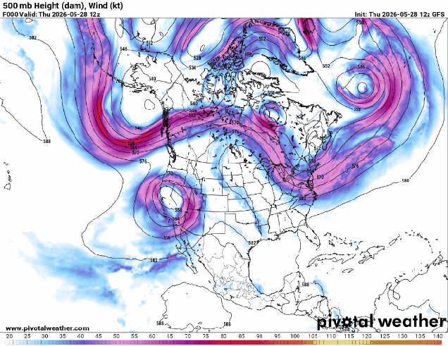
A classic “Omega Block” pattern is setting up across the nation. Loop provided by Pivotal Weather.
The upper-level pattern across the country will settle into an “Omega Block” over the next days. With upper-level lows across the Pacific Northwest and in the Northeast, with a ridge of high pressure in the middle, the flow resembles the Greek letter Omega. This pattern does not allow systems to move across the country swiftly, like they usually do. If you’re underneath one of the upper lows, the pattern isn’t that great for a while. If you’re under the ridge, it’s usually dry and warm to hot, depending on the season. Well, we’re going to be under one of the upper lows through the weekend, but that doesn’t mean it’s going to be miserable the entire time.
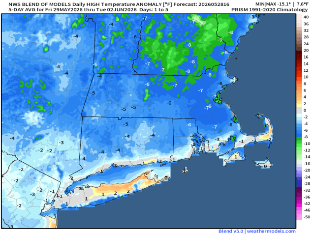
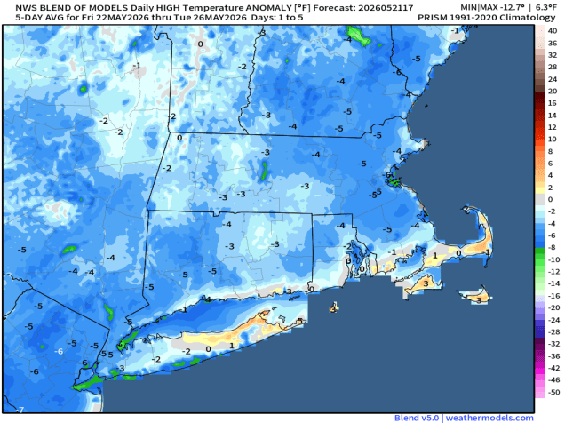
Temperatures will average 5-10 degrees below normal this weekend. Image provided by Weathermodels.com
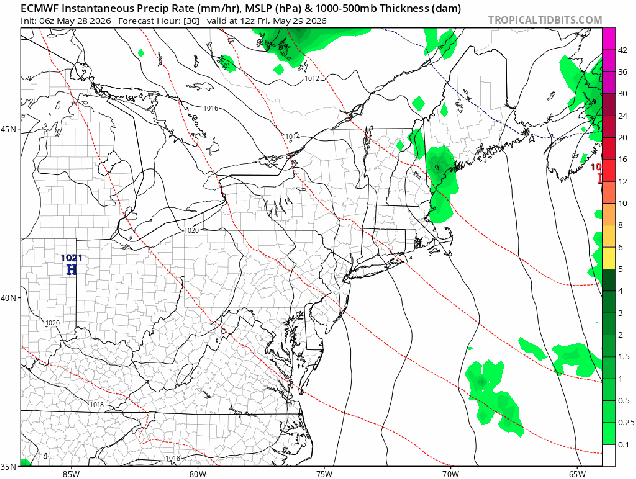
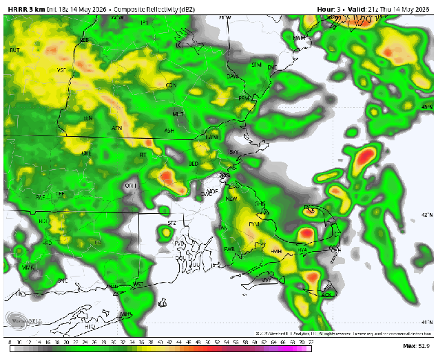
In terms of sensible weather, showers will taper off this evening, and then we’ll remain dry for the overnight and first part of Friday. A potent upper-level disturbance will begin dropping southward from Quebec on Friday, so we’ll see clouds moving in, with rain likely Friday night into Saturday morning. Showers may linger into the afternoon, especially across eastern Massachusetts. The rain won’t be exceptionally heavy, but any rain is welcome, as it helps with the ongoing drought. Along the coast, especially south of Boston, winds will be gusty Saturday afternoon as the system moves offshore and continues to develop, with some gusts to 40 mph possible. With the clouds, rainfall, and cooler air aloft, it will be a chilly day by late-May standards, with temperatures likely in the 50s and lower 60s during the daytime.
Low pressure dropping southward from Quebec will bring in rain and cool conditions for Friday night and early Saturday. Loop provided by Tropical Tidbits.
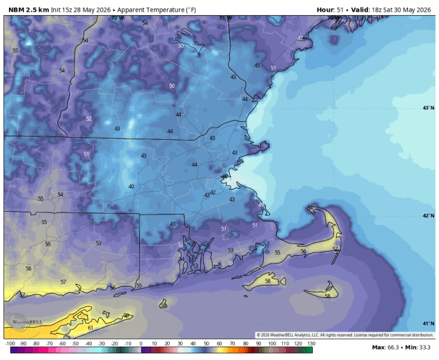
This is where the internet hype machine has gone into overdrive. No, it is not going to feel like mid-winter on Saturday with wind chills in the 30s all day long as some have been claiming. First of all, wind chills in the 30s is not what we normally get in mid-winter to begin with – actual temperatures in the 30s, yes, when it’s milder than normal. Yes, there are a few models that show this potential on Saturday, but just because a model forecasts it, doesn’t mean that is what going to happen. As a colleague of ours is fond of saying “if the models were as good as people think, there’d be no need for meteorologists”.
It will feel like its in the 40s and lower 50s Saturday afternoon. Image provided by WeatherBell.
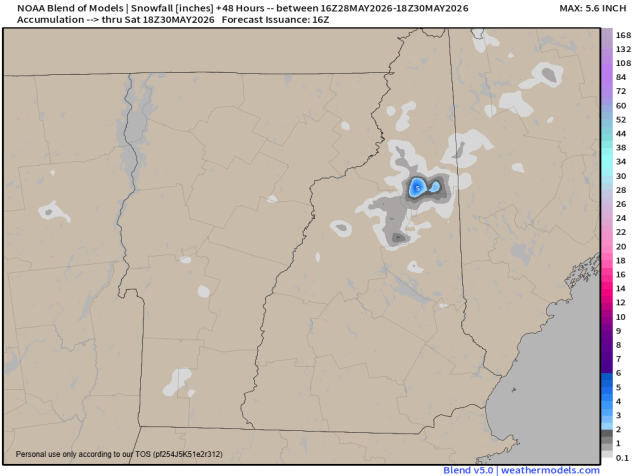
Similarly, we’ve seen plenty of posts about the “snowstorm hitting New England this weekend.” Yes, a storm is coming, as we explained above. Yes, temperatures will be well below normal, which we also have mentioned already. Yes, there may be some snow in the higher elevations of northern New Hampshire and northwestern Maine for a few hours Saturday morning. There could even be some minor accumulations at elevations above 3000 feet. Care to guess how many people in that region live at elevations above 3000 feet? The answer might not be zero, but it’s probably less than 1000 (maybe even less than 100). Also, while this is unusual, it’s actually not that abnormal. Mount Washington has received snow in every month of the year.
A little snow is possible Saturday morning across the highest peaks of Northern New England. Image provided by Weathermodels.com
As for the rest of the weekend, Sunday should be a better day with milder temperatures, but with that upper-level low overhead we’ll see clouds popping up by midday, with a few pop-up showers in the afternoon. Another disturbance will drop down on Monday with a few more clouds and likely a few more showers.
Thursday night: A few showers through the evening, then becoming clear, clouds start to move back in late at night. Low 48-55.
Friday: A mix of sun and clouds through the morning, then clouds thicken up in the afternoon with showers possible by evening. High 65-72.
Friday night: Periods of rain and showers likely. Low 42-49.
Saturday: Showers likely during the morning, some clearing possible by late in the day, windy at times, especially during the morning and early afternoon and along the coastline. High 53-60, but temperatures may stay in the upper 40s for much of the morning and early afternoon, especially across eastern Massachusetts.
Saturday night: Becoming clear. Low 40-47.
Sunday: Some morning sun, then clouds pop up with a few afternoon showers. High 64-71, a little cooler along the coast.
Sunday night: Partly cloudy. Low 47-54.
Monday: More clouds than sun with some showers likely. High 62-69.
Memorial Day Weekend is often referred to as the “Unofficial Start of Summer”. Mother Nature will remind us this weekend that it’s still Spring.
Temperatures will be below normal through the long weekend. Image provided by weathermodels.com
High pressure will slowly move across southern Canada tonight and Friday, resulting in a rather chilly night tonight, but a sunny and seasonably mild day on Friday. As the high moves into Atlantic Canada on Saturday low pressure will move into the Midwest, sending plenty of clouds our way, along with cooler temperatures, thanks to the onshore flow around the high pressure area to our east. Right now, it looks like the high will be strong enough to prevent rainfall ahead of the Midwest storm from getting in here during the day on Saturday, so it will be just a cloudy and cool day. However, that rain will likely move in for Saturday night and Sunday, so if you have any outdoor plans on Sunday, it might be time to look for alternatives. While we’re not expecting heavy rain for most of the region, any rain we get is beneficial, and will help put a dent in the ongoing drought. The rain should taper off Monday morning, with improving conditions in the afternoon as the low pressure area pulls away, so we may salvage a decent day for the holiday.
The heaviest rain should stay south and west of our area this weekend. Images provided by Pivotal Weather.
Thursday night: Gradual clearing. Low 42-49.
Friday: Sunshine filtered through high clouds at times. High 62-69, a little cooler along the coast.
Friday night: Increasing and thickening clouds. Low 44-51.
Saturday: Plenty of clouds, chance for a shower or two late in the day, favoring areas near the South Coast. High 59-66.
Saturday night: Cloudy with showers developing. Low 45-52.
Sunday: Plenty of clouds with occasional rain and showers, breezy. High 54-61.
Sunday night: Cloudy with more showers and some periods of steadier rain, especially across Cape Cod and southeastern Massachusetts. Low 47-54.
Monday: Showers ending early, some late day sunny breaks may develop. High 65-72.
The warmer weather that you’ve been waiting for is finally arriving.
Showers taper off this evening, but don’t end until Friday afternoon. Loop provided by WeatherBell.
Low pressure passing south of New England brings us some much-needed rain this evening, tapering off to showers overnight as the low gets stuck under an upper-level low and only slowly pulls away. Friday will feature lots of clouds, cool temperatures, and some additional showers, especially during the morning, before the low pulls far enough away to lose its influence on our weather. High pressure then builds in, with skies clearing out Friday night, setting the stage for a fantastic weekend weatherwise. Sunshine is likely for much of Saturday, with some clouds around during the afternoon as the upper-level low remains nearby, but we should see temperatures getting well into the 70s away from the South Coast thanks to gusty southwest winds. Sunday looks even better, for the most part. We’ll have partly to mostly sunny skies with temperatures topping 80 inland, 70s or 60s along the coast thanks to a seabreeze, as winds will be lighter. However, we’ll be watching a backdoor cold front trying to move down the coast. How far south it gets and when it does so are a bit of a question mark. This could allow much cooler air to move into at least coastal areas late Sunday into early Monday, but it does look like it should start to lift back northward on Monday, allowing areas that turned cooler to warm back up, while inland areas may stay very warm. Although it isn’t technically part of this outlook, we figured we’d point out the fact that Tuesday as the potential to be a very warm to hot day, with temperatures possibly topping 90 inland.
Sunday looks spectacular right now. Image provided by weathermodels.com
Thursday night: Rain likely this evening tapering off to widely scattered showers and drizzle, mainly north of the Mass Pike. Low 44-51.
Friday: Mostly cloudy with a few widely scattered showers and some drizzle, mostly during the morning. High 52-59.
Friday night: Becoming partly cloudy to clear. Low 43-50.
Saturday: Sunshine and a few afternoon clouds, breezy. High 70-77, a little cooler near the South Coast and Cape Cod.
Saturday night: Partly cloudy. Low 52-59.
Sunday: Mostly sunny. High 75-82, cooler across Cape Cod.
Sunday night: Partly cloudy. Low 49-56.
Monday: Partly to mostly sunny. High 65-72 along the coast, 73-80 inland.
Much of the weekend will feature unsettled conditions.
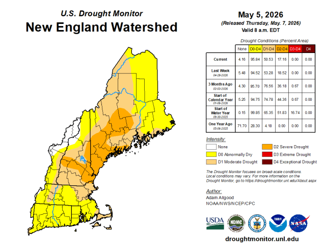
Drought conditions remain in place. Image provided by the National Drought Mitigation Center.
An upper-level low pressure system sitting over southeastern Canada will control our weather for the weekend. A cold front continues to push offshore tonight while high pressure builds in with dry and cool conditions. Friday starts off with sunshine, but with colder air aloft we’ll see clouds quickly popping up during the morning, and a few widely scattered showers possible during the afternoon. More clouds move in at night as a weak disturbance rotating around the upper-level low will generate a weak storm system that will bring in some rain Saturday afternoon and evening. High pressure briefly builds in behind the system with some drier and warmer for Sunday, but it won’t last long. Another disturbance rotating around the upper-level low will trigger another low pressure system over the Mid-Atlantic states that will pass south and east of New England on Monday. We’ll see rain return Sunday night, continuing on Monday with cooler weather returning once again.
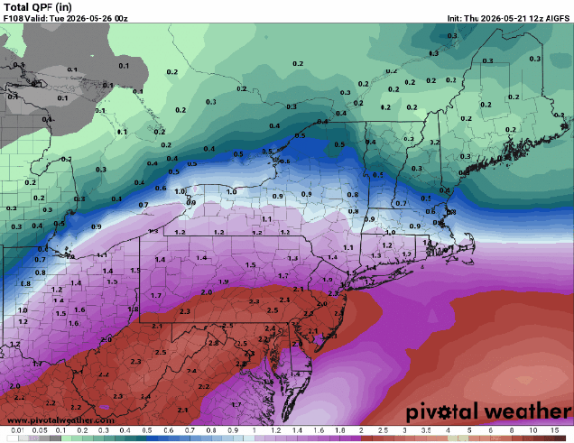
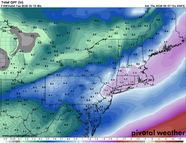
Some beneficial rainfall is possible between Saturday and Monday’s storms. Images provided by Pivotal Weather.
Unfortunately, this pattern, with upper level lows moving out and new ones moving in, will likely continue for at least the next few weeks, resulting in near to below normal temperatures and episode of showers every few days. We need the rain to help keep the brush fire danger low and put a dent in the drought, but aside from a nice day or two every now and then conditions will remain dreary for a while. There is some signs that a warmer pattern could move in for the end of the month, but how long it lasts, or if it even moves in, are yet to be determined.
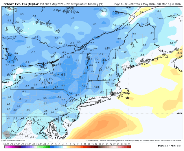
On average temperatures will be a little below normal into early June. Image provided by WeatherBell.
Thursday night: Clear to partly cloudy, cool. Low 38-45.
Friday: Morning sun with afternoon clouds and a few widely scattered showers, breezy. High 55-62.
Friday night: Clear during the evening, clouds stream back in after midnight. Low 38-45.
Saturday: Cloudy and breezy with some rain moving in by early afternoon. High 56-63.
Saturday night: Mostly cloudy, showers ending by midnight. Low 45-52.
Sunday: Partly sunny, slight chance for an afternoon shower. High 65-72, cooler across the South Coast and Cape Cod.
Sunday night: Cloudy with showers developing after midnight. Low 45-52.