Yes, we’re a little later than normal, but we did warn you that would likely be the case. Without further delay, let’s get to a forecast that has some big changes coming to the area.
The rest of today should be pretty self explanatory with high pressure in control, so let’s jump ahead to tomorrow. A warm front will move through, and that will bring us a return to summer-like air as we flip the calendar to October. A few showers are possible ahead of the warm front, but overall, we’ve got a decent day coming up, despite some cloud cover.
This brings us to Wednesday – the transition day. We’ll start off warm, and could get very warm, but a strong cold front will move through. Exactly when that front comes through is still a little up in the air, which will have a significant impact on the temperatures. If it comes through late enough, we could see some locations get into the 80s. Behind it, temperatures will quickly drop. We’ll also have some showers and possibly thunderstorms to deal with as the front moves across the region.
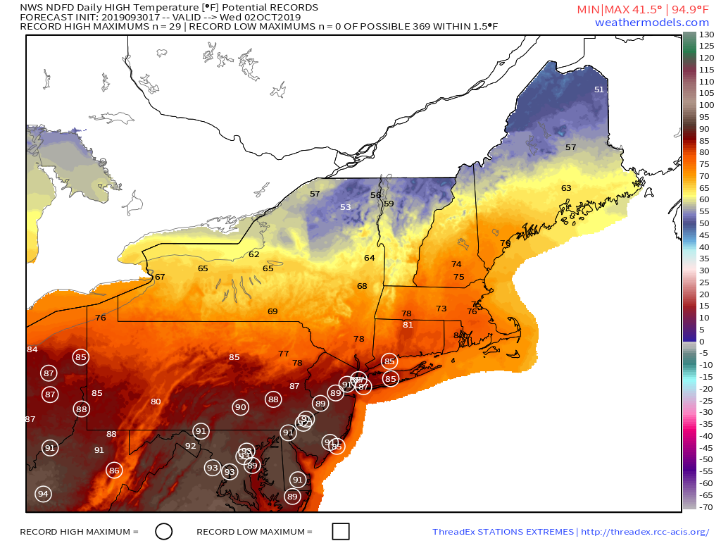
Looks like any record high temperatures on Wednesday will be confined to New York City and points south and west, as the front will probably come through a little too early around here. Image provided by Weathermodels.com
The front settles south of the region Wednesday night and we may even clear out a bit, but that will be short-lived. Another system quickly approaches from the west with rain likely for much of Thursday and into early Friday. The rain isn’t the only part of Thursday that you’ll hate. Temperatures will likely be 20-30 degrees colder than Wednesday, with highs only in the 50s. Yup, fall will finally arrive. High pressure builds in behind that system for Friday into the weekend, with cool conditions. Some frost is possible for much of the region.
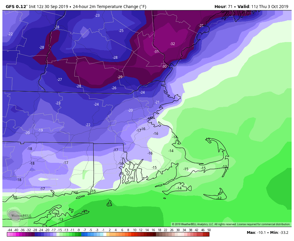
Temperatures Thursday morning will be 20-30 degrees cooler than Wednesday morning behind a strong cold front. Image provided by WeatherBell.
Monday afternoon: Partly sunny. High 59-66, coolest along the coast.
Monday night: Partly to mostly cloudy, chance for a few showers, mainly north of the Mass Pike. Low 46-53, but temperatures may rise a bit after midnight.
Tuesday: A few showers possible early, then some sunshine may develop. Breezy and warmer. High 68-75.
Tuesday night: Mostly cloudy with some showers likely. Low 61-68.
Wednesday: Cloudy and mild with scattered showers, possibly a thunderstorm. Turning sharply cooler in the afternoon. High 73-80.
Thursday: A few sunny breaks early, mainly from the Merrimack Valley northward, otherwise cloudy with showers developing, becoming a steady rain late in the day and at night. High 52-59.
Friday: Cloudy with showers ending early, then becoming partly to mostly sunny and windy. High 57-64.
Saturday: Plenty of sunshine. High 55-62.
Sunday: More clouds than sun., breezy. High 59-66.
The autumnal equinox occurs at 3:50AM today, which means that by the time you read this, fall will have already started. Naturally, it will still feel like summer today.
We’ve been very dry across much of the Northeast and Mid-Atlantic states over the past few months. Unfortunately, widespread beneficial rainfall is not in the forecast for most of us. Image provided by the Northeast Regional Climate Center.
We’ll start off fall with unseasonably warm temperatures once again, but clouds will start to move in ahead of a cold front. This front will produce some showers and maybe a few thunderstorms later today and tonight as it moves through the region. Cooler air settles in behind the front for Tuesday, but an upper-level low moving across the Northeast may result in some clouds and possibly another shower or two.
Some downpours are possible with the showers and embedded thunderstorms today. A few places could get soaked in a short periods of time. Image provided by WeatherBell.
High pressure builds in for Wednesday and Thursday with dry weather. Temperatures will remain above normal, and should start to warm up again, but another cold front will quickly follow. This one will produce some more showers late Thursday and Thursday night, with high pressure building back in for Friday.
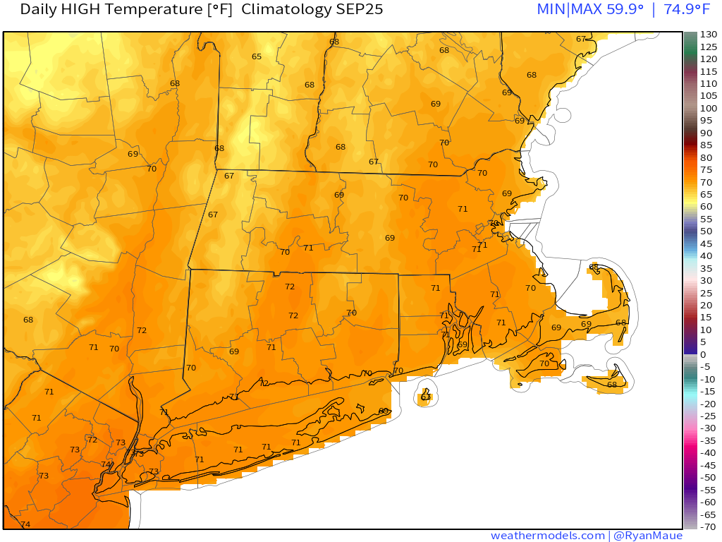
Average high temperatures for late September are right around 70 degrees for this area. Image provided by Weathermodels.com
For next weekend, right now, it looks like we’ll be in a similar pattern with a warm day on Saturday, then a cold front brings in showers followed by cooler weather on Sunday. However, there is a chance that this front gets hung up north and west of the region or possibly even washes out. If that were to happen, Sunday could end up significantly warmer. We’re leaning against this scenario right now, but it is a possibility.
When will fall finally arrive? Well, right now, it looks like the unseasonably warm weather will continue into at least the first few days of October before we see a pattern change. Cooler weather looks like it may arrive late next week, which is perfect as far as we’re concerned, because that’s when hockey season starts. It shouldn’t be in the 70s around here when the Bruins are playing, unless it’s deep in the playoffs in May or June.
Fall is here and hockey is back next week, which is a welcome sight to us. Image provided by NHL.com
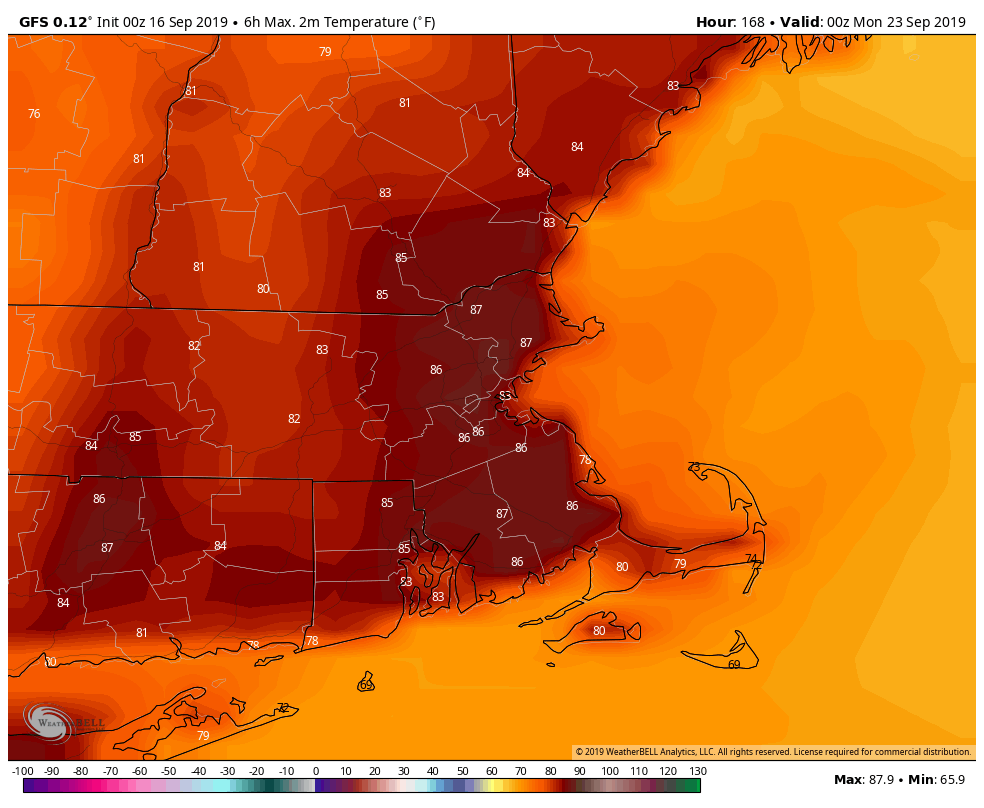
Monday: Some morning sunshine, then increasing clouds and breezy with showers and possibly some thunderstorms developing late in the day. High 81-88, cooler along the South Coast.
Monday night: Mostly cloudy with showers and thunderstorms ending from west to east, skies will clear out north and west of Boston overnight. Low 58-65.
Tuesday: A mix of sun and clouds, chance for a shower or two in the afternoon, mainly north and west of Boston. High 71-78.
Tuesday night: Mostly clear. Low 48-55.
Wednesday: Sunshine and some afternoon clouds. High 68-75.
Thursday: Morning sunshine, then becoming mostly cloudy and breezy during the afternoon with some showers possible late in the day and into the evening. High 74-81.
Friday: Sunshine and a few clouds. High 69-76.
Saturday: Intervals of clouds and sunshine with a chance for a few showers. High 74-81.
Sunday: Plenty of clouds, some sunny breaks develop in the afternoon. High 70-77.
Note – this outlook is usually posted very early Monday morning. Next week, it may not get posted until late morning. We at StormHQ are taking a little road trip next week to western New York, to watch the Patriots stomp the Bills on the road to their seventh Super Bowl title. Since we have an early morning flight home Monday, we may not get a chance to write and subsequently post the weekly outlook until we’re back at the StormHQ World Headquarters Compound until late Monday morning.
This may be one of the shortest blog posts we’ve ever written, because the forecast for this week is ridiculously simple.
As you can see in this loop of the GFS model, there will be little to no rainfall this week across our area. Also, unless you’re taking a boat offshore, you don’t have to worry about Hurricane Humberto either. Loop provided by Tropical Tidbits.
A weak disturbance will cross the region today, with some clouds and maybe a shower or two here or there. Maybe. We’re not even convinced that any will pop up. A weak backdoor cold front may produce a few showers early Wednesday, mainly along the coast. Otherwise, high pressure is in control for most of the week and into the weekend. It’ll be on the cool side for Tuesday into Thursday, then we’ll warm up for Friday and the weekend. That’s it. That’s the forecast for the week. Really.
Sunday is the last day of (astronomical) summer, and the GFS thinks it’ll be a warm one. Image provided by WeatherBell.
Monday: Partly to mostly sunny north of the Mass Pike. Intervals of clouds and sunshine south of the Pike with just a very slightly chance for a shower. High 68-75.
Monday night: Clear skies. Low 47-54.
Tuesday: Sunshine and a few clouds. High 64-71.
Tuesday night: Becoming partly to mostly cloudy, chance for a few showers or some drizzle, mainly along the coast. Low 48-55.
Wednesday: A shower or some drizzle early, then becoming partly sunny. High 61-68, coolest along the coast.
Thursday: Unlimited sunshine (from sunrise to sunset only). High 65-72, coolest along the coast.
Friday: Wall-to-wall sunshine. High 72-79.
Saturday: Sun, sun, and more sun. High 76-83.
Sunday: Mostly sunny, maybe a couple of clouds just for a chance of pace. High 78-85.
No hurricanes to worry about this week, just a cold front one day, and high pressure for most of the rest of the week.
We start the week off with high pressure in control, keeping us on the cool side today and Tuesday. Temperatures will actually be a little bit below normal for mid-September. The cool and dry weather won’t last though, as a warm front moves through Tuesday night, likely producing a few showers as it comes through. Once the front its through, we’ll have some warm and somewhat humid conditions around for Wednesday. We will have another cold front coming through late Wednesday or early Thursday. This front may produce another round of showers and thunderstorms. Thursday’s temperatures will be determined by when that front comes through. The longer it takes, the better the chance that Thursday is also a warm day, which is the way we’re leaning right now.
High temperatures are normally in the middle 70s at this time of year. Image provided by Weathermodels.com
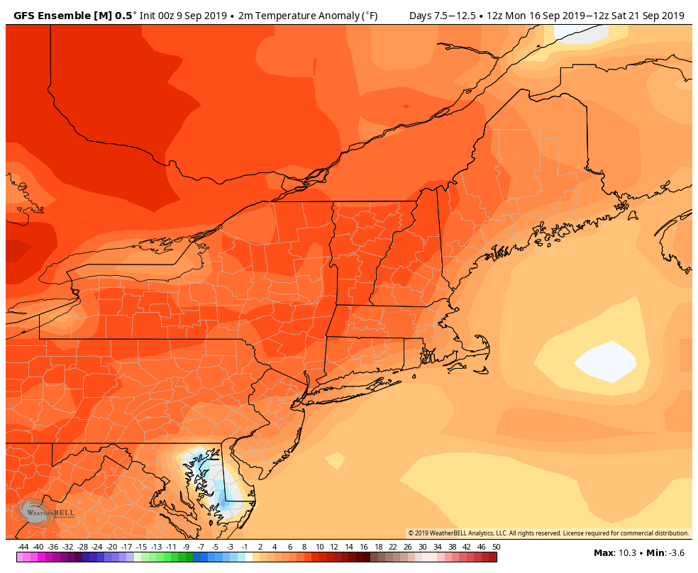
High pressure builds in behind the front, with cooler weather likely on Saturday, but again, it will be short-lived. As the high slides off to the east, we’ll warm up again on Saturday before another cold front approaches, possibly producing some more showers or thunderstorms. That front looks like it won’t do much, as Sunday could be another warm day. In fact, it’s looking like a good chunk of next week could be warm, with temperatures getting into the 80s. Don’t put away those summer clothes just yet!
Temperatures may average several degrees above normal next week, with highs above 80 possible more than a few times. Image provided by WeatherBell.
Monday: Intervals of sunshine and clouds. High 67-74, coolest right along the coast.
Monday night: Clear to partly cloudy. Low 48-55.
Tuesday: A sunny start, clouds move in during the afternoon. High 68-75, coolest right along the coast.
Tuesday night: Partly to mostly cloudy with some showers possible. Low 55-62.
Wednesday: A shower or two early, then becoming partly sunny and breezy. High 78-85.
Thursday: A mix of sun and clouds, slight chance for a shower or thunderstorm. High 75-82.
Friday: Partly to mostly sunny. High 64-71.
Saturday: More clouds than sun, breezy, showers and thunderstorms possible late in the day. High 74-81.
Sunday: Partly sunny, chance for a shower or thunderstorm. High 76-83.
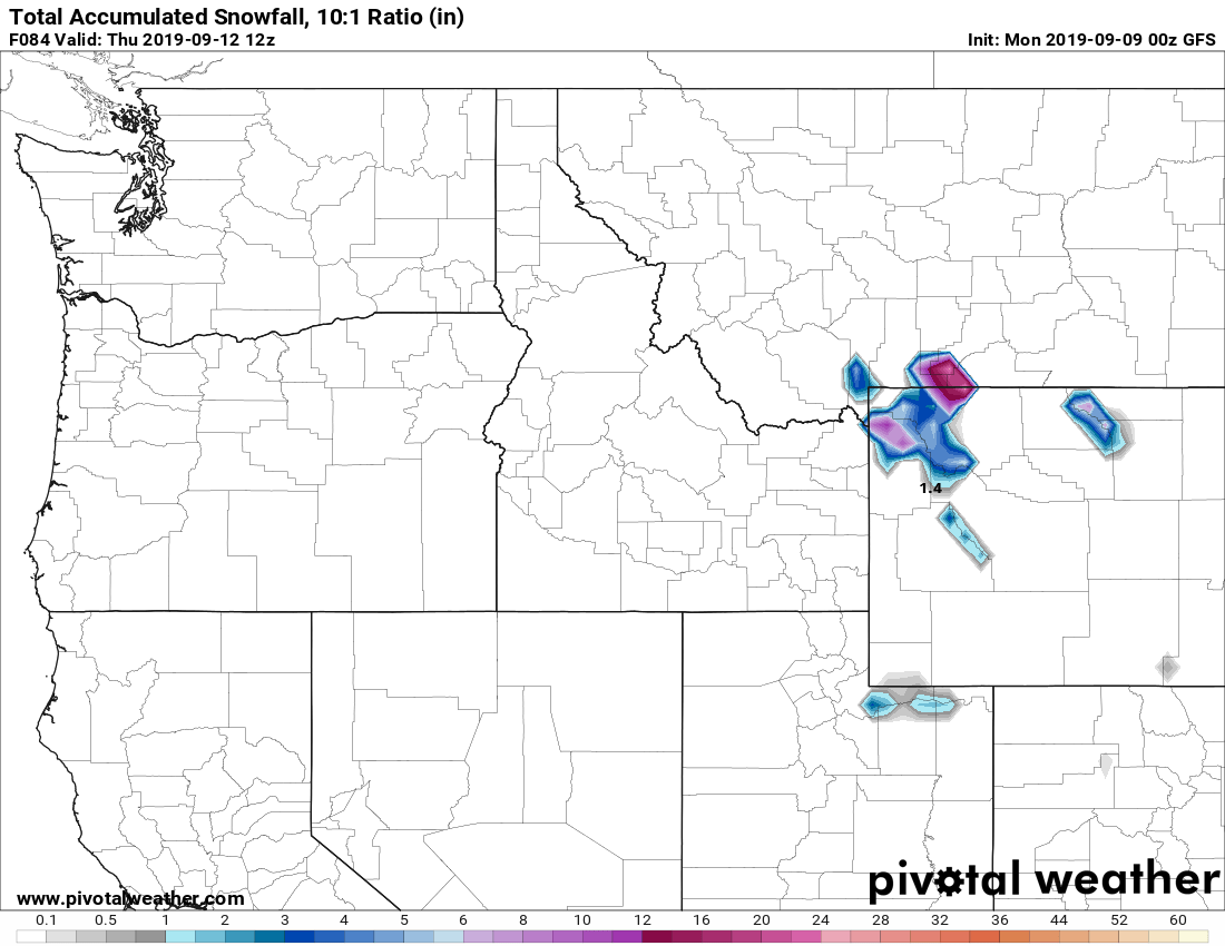
It’s getting to be that time of year. Some higher elevation snow is possible in parts of Wyoming and Montana on Wednesday. Image provided by Pivotal Weather.
Hurricane Dorian continues to blast Grand Bahama Island this afternoon, but elsewhere, the Atlantic is getting active quickly.
#Dorian Has wreaked havoc on Abacos and Grand Bahama Islands over the past 24+ hours. Here is a satellite recap as it approached, made a 2nd landfall and then stalled out over Grand Bahama Island. Now the storm is finally starting to pull away. In its wake utter devastation… pic.twitter.com/nyFzaPxQOF
As of early Tuesday afternoon, Hurricane Dorian was centered about 65 miles north of Freeport, Grand Bahama Island. Dorian is no longer stationary, but it’s not exactly racing along, drifting toward the northwest at 5 mph. After peaking as a Category 5 on Sunday, Dorian has weakened to a Category 2 hurricane this afternoon, with maximum sustained winds near 110 mph. The eyewall has finally moved away from Grand Bahama Island, so continues will slowly improve today.
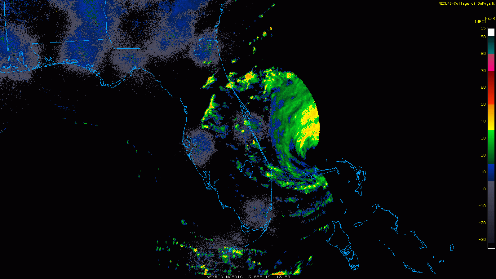
Dorian’s eye shows up rather nicely on radar from Florida this afternoon. Loop provided by the College of DuPage.
At it’s peak, Dorian had sustained winds of 185 mph, which is tied for the 2nd highest on record in the Atlantic Basin, and the highest for a storm that far north. Only Hurricane Allen in 1980 was stronger, with top winds near 190 mph. Dorian’s lowest pressure of 910mb, is tied for the 9th lowest on record in the Atlantic. It is the strongest hurricane ever to make landfall in the Bahamas.
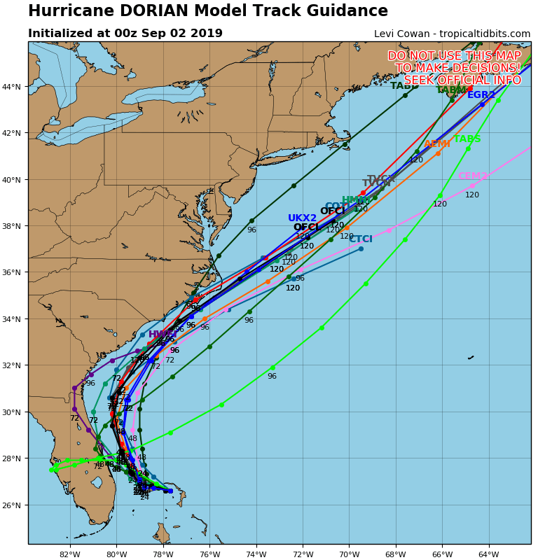
As for Dorian’s future, the thinking really hasn’t changed much in the past few days. The slow northwestward motion has started, and a turn more toward the north with some acceleration is expected later today and Wednesday as a trough of low pressure approaches the East Coast. This should keep the center of the storm 75 miles or so off the Florida coastline. The outer bands of Dorian will continue to impact coastal Florida, with bouts of heavy rain and gusty winds at times. A Hurricane Warning remains in effect from central Florida up into parts of South Carolina.
Model forecasts for the track of Hurricane Dorian. Image provided by Tropical Tidbits.
To the north, Dorian should start to turn northeastward later Wednesday into Thursday, coming very close to the coastline of both South and North Carolina. This will bring hurricane conditions to these states, and a Hurricane Watch has been issued. Although the official forecast from the National Hurricane Center keeps the center offshore, it will be close enough that even a slight wobble to the left could result in landfall. Whether it makes landfall or not, strong winds, torrential rainfall and very rough surf are expected in these areas over the next couple of days.
GFS model forecast for rainfall across the Southeast through Friday. Image provided by Weathermodels.com
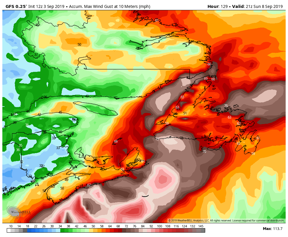
Once past the Carolinas, Dorian should continue northeast, and start to transition into an extratropical storm. That doesn’t mean that it’s done impacting land though. It could graze Cape Cod and the islands with some rain and gusty winds late Friday into early Saturday, but over the weekend it will likely have a significant impact on Atlantic Canada. Heavy rain is likely across parts of Nova Scotia, New Brunswick, Prince Edward Island, and into Newfoundland. While some locations could pick up 2-4 inches of rain, the biggest impact will be from the wind. Sustained winds of 30-50 mph are expected with gusts of 60-70 mph or more, especially along the coastline.
Peak wind gusts expected across Atlantic Canada through Sunday evening according to the GFS. Image provided by WeatherBell.
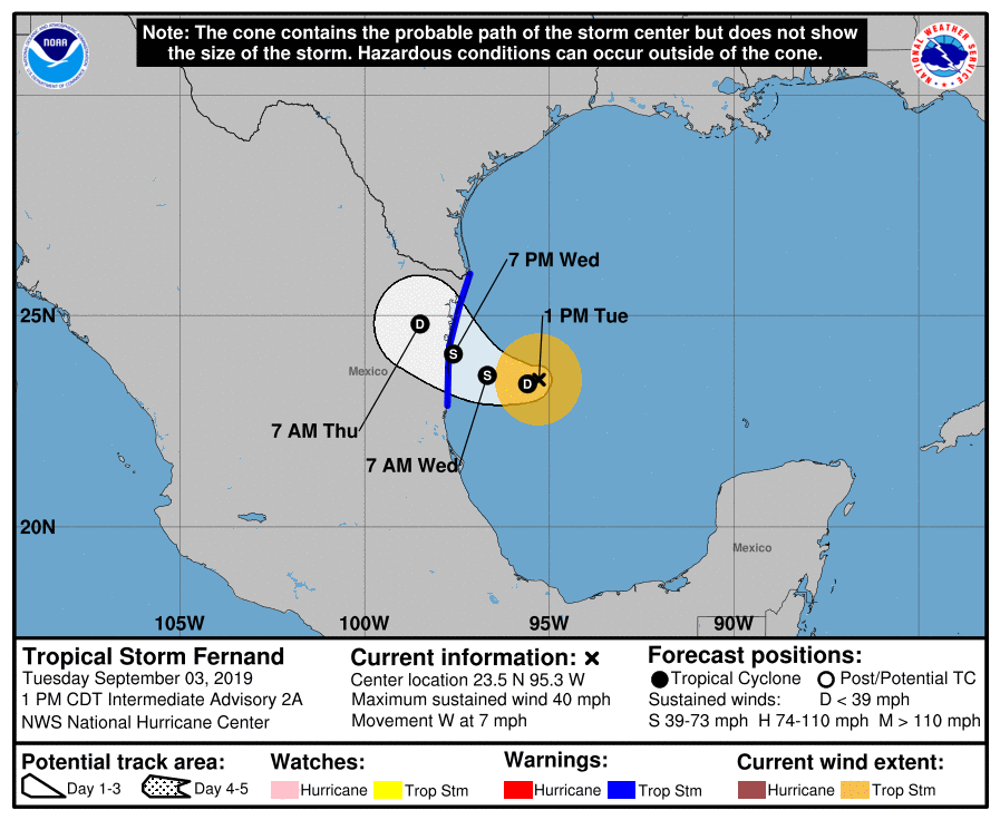
Dorian isn’t the only active storm in the Atlantic any more. Tropical Storm Fernand formed this afternoon in the Gulf of Mexico. As of early Tuesday afternoon, it was centered about 160 miles east of La Pesca, Mexico, moving toward the west at 7 mph. It has maximum sustained winds near 40 mph, and is expected to strengthen a little more over the next 24 hours. A Tropical Storm Warning has been issues for parts of northeastern Mexico. The system will likely make landfall late Wednesday, with the biggest impact likely to be from heavy rainfall. Rainfall totals of 6-12 inches and locally heavier will produce flooding and mudslides across the area. Heavy rain is expected across parts of South Texas, where 2-4 inches may fall, resulting in some flash flooding.
Forecast track for Tropical Storm Fernand. Image provided by the National Hurricane Center.
But wait, there’s more! There are two other systems in the Atlantic that are being monitored this afternoon. The stronger of the two is a few hundred miles west of the Cape Verde Islands. This system will likely become a tropical depression later today or tonight. It should turn more towards the northwest and stay harmlessly out at sea for the next several days likely not impacting any land areas at all.
Model forecasts for the track of a tropical disturbance in the eastern Atlantic. Image provided by Tropical Tidbits.
Another disturbance is located several hundred miles south of Bermuda this afternoon. This system is not well-organized, and conditions aren’t very favorable for further development. It will be monitored over the next few days, and may bring some squally weather to Bermuda later this week.
Satellite loop of the Atlantic showing TD7 on the left edge of the screen, Dorian near the Bahamas, a disturbance south of Bermuda, and another disturbance in the eastern Atlantic. Loop provided by NOAA.
If that’s not enough, there’s another wave still over western Africa that will move into the Atlantic later this week. Forecast models are showing the potential for that wave to develop as well. This shouldn’t be a big surprise, September is the peak of hurricane season. This is just the Atlantic – we didn’t even get into the Pacific, where Hurricane Juliette is a Category 3 Hurricane southwest of Mexico, Typhoon Lingling is passing east of Japan on its way towards Korea, Tropical Storm 14W is expected to become a typhoon passing north of the Northern Mariana Islands on its way towards Japan, and Tropical Depression Kajiki is making landfall along the coast of Vietnam.
Believe it or not, there is weather besides Dorian taking place right now, and some of it will impact us. Oh Dorian may at some point as well, but we’ll get to that.
The week starts off with a cold front approaching from the west. If you’ve got outdoor plans for Labor Day, you should be OK through at least midday. Although we’ll have plenty of clouds around, the showers and thunderstorms we’re expecting should hold off until the afternoon. Some of these showers and storms could produce some heavy rainfall, especially during the late afternoon and evening hours.
The front pushes offshore, with showers ending overnight, then high pressure builds in for Tuesday with mild and drier conditions. The high shifts offshore on Wednesday, allowing warmer and more humid air to move back in. Temperatures should be well into the 80s, and a few places could even get to 90. However, another cold front will move through late in the day, with some additional showers likely. Behind that front, much cooler air settles in on Thursday with high pressure building back in.
Temperatures should get well into the 80s on Wednesday. Image provided by WeatherBell.
This brings us to the Dorian part of the forecast. If Dorian is to have any impact up here, it will be in the Friday/Saturday time frame. Dorian will produce some rough surf along the coastline, but beyond that, we’re not sure if there will be any other impacts. A lot will be determined by the track that Dorian takes, but it should pass well south and east of New England. Whether it’s still a hurricane, a tropical storm, or even an extratropical storm, is too tough to predict this far out. Some of the models have it pass close enough to bring in some heavy rain and gusty winds, especially to Cape Cod and Southeastern Massachusetts. Some of the local TV meteorologists were already hyping this up on the 11pm news Sunday night. Sure, it’s possible that this could happen. It’s also possible that the storm stays far enough offshore to have little to no impact on us beyond the rough surf. For now, we’re going to play the middle ground on the forecast, but obviously, we’ll be doing some special blog updates on Dorian during the week, as it’s future becomes more clear.
Most of the forecast models keep Dorian well south and east of New England, for now. Image provided by Tropical Tidbits.
High pressure will be building into the Northeast for the end of the week and the weekend. If Dorian stays too far offshore, it will be dry and cool around here for Friday through Sunday. If Dorian does have some impact, it’ll just be dry and cool on Sunday behind the storm.
Labor Day: Mostly cloudy with showers and thunderstorms likely in the afternoon. Some of the storms may produce heavy rainfall. High 70-77.
Monday night: Showers and thunderstorms ending, followed by clearing late at night. Low 56-63.
Tuesday: Clouds may linger across Cape Cod in the morning, otherwise partly to mostly sunny. High 74-81.
Tuesday night: Clear to partly cloudy. Low 58-65.
Wednesday: Becoming partly to mostly cloudy, breezy, and humid, with showers and thunderstorms likely during the afternoon. High 80-87.
Thursday: Sunshine filtered through increasing high clouds streaming northward from Dorian. High 67-74.
Friday: Partly to mostly cloudy, breezy, and cool with a chance of rain, especially south of Boston. High 63-70.
Saturday: Breezy with a chance of rain early, then becoming partly to mostly sunny. High 69-76.