Memorial Day has arrived – the traditional start of summer. While much of the upcoming week will feel like summer, today will feel like Spring, which of course, it still is.
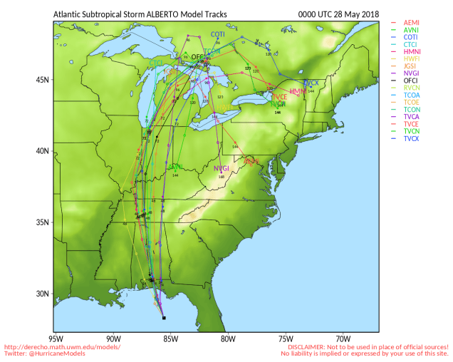
Alberto should continue on a general northerly track for the next few days, quickly weakening once it moves inland. Image provided by the University of Wisconsin.
We’ll start off this forecast with a quick update on Alberto. As of 11pm Sunday, subtropical storm Alberto was centered about 95 miles south-southwest of Apalachicola, Florida, moving toward the northwest at 9 mph. Maximum sustained winds were near 65 mph. Landfall is expected near or just east of Fort Walton Beach, Florida Monday morning. While gusty winds and storm surge will be threats along the coastline, the much bigger threat will be heavy rain and flooding across much of the Southeast over the next few days, spreading into the Tennessee and Ohio Valley towards midweek. Alberto, or what’s left of it, could impact our weather late in the week (More on that in a bit).
Up here, the forecast is fairly easy for much of the week. High pressure starts to build into the region today. We’ll start the day off with some clouds and cool temperatures, but sunshine will develop, and temperatures will actually warm up close to where they should be in late May. After that, with high pressure in control, sunny and warm conditions are expected for Tuesday through Thursday.
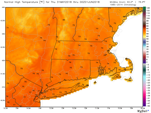
Average high temperatures for the last few days of May are in the lower to middle 70s across the region. Image provided by WeatherBell.
At the end of the week is where things get interesting. What’s left of Alberto heads towards the St. Lawrence Valley on Friday, sending clouds and showers into the region, but it should remain warm. The bigger questions come during the weekend. A secondary area of low pressure will form, possibly bringing some steadier and heavier rain to the region. The question that the models haven’t resolved yet is “where does it form?” One model suggests it forms right over the Northeast, then moves offshore before stalling out, which would mean a rainy Saturday, but improving conditions on Sunday. Another model suggests that it forms to the south, which means a rainy and warm Saturday and a rainy and much cooler Sunday. Yet another model also says that it forms to the south, but so far south that high pressure builds in on Sunday, so after a rainy Saturday, we’d have clearing but also chilly temperatures on Sunday. At this point, we’re not sure which way to go, so we’ll play the middle ground (yeah, it’s a cop-out, but it’s also a week away, so give us a break).
At least one models thinks that next Sunday could be another chilly day. We’re not convince it will be this chilly yet. Image provided by Weathermodels.com
Memorial Day: A cloudy start, maybe a little drizzle as well, then skies become partly to mostly sunny in the afternoon. High 60-67 along the coast, 68-75 inland.
Monday night: Clear to partly cloudy. Low 53-60.
Tuesday: Partly to mostly sunny. High 80-87.
Tuesday night: Clear skies. Low 50-57.
Wednesday: Plenty of sunshine. High 72-79, coolest along the coast.
Thursday: A mix of sunshine and clouds. A few showers are possible at night. High 78-85, cooler along the south coast.
Friday: Mostly cloudy with a chance of showers. High 76-83.
Saturday: Cloudy and breezy with showers likely, possibly a period of steady rain. High 70-77.
Sunday: Partly to mostly cloudy and breezy with a chance of showers. High 63-70.
Officially, hurricane season in the Atlantic Basin starts on June 1 and ends on November 30. In recent years, Mother Nature has not adhered to that calendar, and she won’t this year either.
GOES-16 satellite loop of newly-developed Subtropical Storm Alberto in the northwestern Caribbean. Loop provided by NOAA.
A cluster of thunderstorms that has been slowly organizing over the Yucatan Peninsula and northwestern Caribbean Sea for the past several days has been designated as Subtropical Storm Alberto by the National Hurricane Center this morning. As of 11am EDT, Alberto had maximum sustained winds of 40 mph, and was centered about 55 miles south of Cozumel, Mexico, moving toward the north-northeast at 6mph. Tropical Storm Watches have been issued for portions of western Cuba as well as Mexico’s Yucatan Peninsula.
Latest model forecasts for the track of Alberto. Image provided by Tropical Tidbits.
Most of the forecast models are in good agreement that the system should continue northward toward the central Gulf Coast, with some strengthening expected. Westerly wind shear will keep Alberto fairly weak through Saturday, but as the shear relaxes and Alberto moves over the warm waters of the Gulf, more strengthening is expected. While Alberto is not currently expected to reach hurricane strength, if conditions are favorable for rapid strengthening before landfall, it is possible.
GFS model forecast for rainfall through Tuesday across the Southeast. Image provided by Weathermodels.com
While gusty winds and storm surge are threats near where the system makes landfall, by far, the bigger threats are heavy rain and flooding. The shield of heavy rain will extend far from the center, bringing heavy rain to much of the Southeast and the Gulf Coast during the Memorial Day Weekend. Widespread totals of 2-4 inches are expected, with localized totals in excess of 10 inches possible in some areas. Flood watches have already been issued for parts of the region, and more are expected to be issued in the coming days. Once inland, Alberto may slow down, which could keep the heavy rain going well into next week across portions of the Tennessee and Ohio Valleys.
Location where all tropical cyclones have formed in the Atlantic and Eastern Pacific during the last 10 days of May. Image provided by the National Hurricane Center.
Last year, what turned out to be a very active season got off to a very early start when Tropical Storm Arlene formed in the central Atlantic on April 19. The 2016 season got an even earlier start when Hurricane Alex formed on January 14 and Tropical Storm Bonnie developed on May 27. In 2015, Tropical Storm Ana formed on May 8, and made landfall near Myrtle Beach, South Carolina on May 10, the earliest landfalling storm on record in the United States. The peak of the season usually occurs from mid-August through late September, but an early start isn’t unusual. Based on data from 1966-2009, the first named storm in the Atlantic doesn’t normally develop until July 9 and the first hurricane doesn’t develop until August 10.
Name List for the 2018 Atlantic Hurricane Season. Image provided by NOAA.
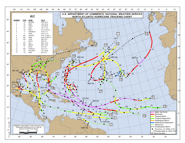
An early start is not always a harbinger of what the season will bring. NOAA issued their seasonal hurricane outlook on Thursday, and it calls for a 35 percent chance for an above normal season, a 40 percent chance for a normal season, and a 25 percent chance for a below normal season. Many in the media are reporting that as a “75 percent chance for a normal or above normal season.” That’s because disasters = ratings. If you’re not a fan of disasters, you could interpret this as a 65 percent chance for a normal or below normal season. (See what we did there?) An average season consists of 12 named storms, of which 6 become hurricanes and 3 become major hurricanes. The 2017 season consisted of 17 named storms, of which 10 became hurricanes and 6 were major hurricanes. These storms produced an estimated $280 billion in damage, making 2017 the costliest season on record. Many parts of the Caribbean, as well as Texas and Florida are still struggling to recover from direct hits by Hurricanes Harvey, Irma, and Maria.
2017 was a hyper-active season in the Atlantic, but also a devastating one, with several storms, many powerful, making landfall. Image provided by the National Hurricane Center.
While last year was both very active and featured a lot of landfalling storms, an active season doesn’t guarantee that a storm will make landfall in the United States though. In 2010, there were 19 named storms, 12 hurricanes, and 5 major hurricanes. Only 1 storm, Tropical Storm Bonnie, made landfall in the United States. On the flip side, 1992 was a quiet season, with just 7 named storms, 4 hurricanes, and 1 major hurricane, with the first named storm not forming until August 16. Of course, that first storm was Andrew, which slammed into South Florida on August 24 as a Category 5 hurricane, one of just 3 Category 5 storms to ever make landfall in the United States.
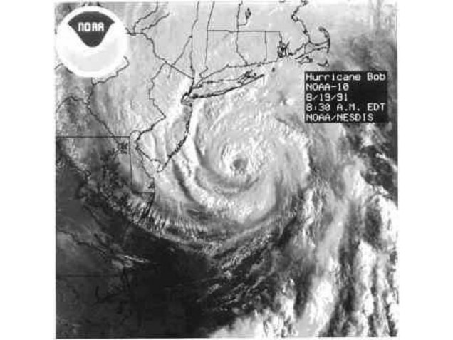
Here in New England, we should always pay attention when a storm is nearing the Bahamas, as those are the ones that have the potential to impact us. Using data back to 1851, a tropical storm makes landfall in Southern New England or Long Island once every 4 years, while a hurricane makes landfall once every 8 years. The last tropical storm to make landfall was Irene, which passed right over New York City in 2011, so we’re about due for another one. As for hurricanes, while we’ve been threatened several times in the past few years, the last one to make landfall was Hurricane Bob in 1991. That 27-year gap is the 2nd longest on record, second only to the 28 year gap between 1896 and 1924. In other words, we are very overdue.
Satellite photo of Hurricane Bob approaching New England. Bob was the last hurricane to make landfall in New England – 27 years ago. Image provided by NOAA.
While Alberto has formed and is moving into the Gulf of Mexico, it will not be a threat to New England. Even if something were to form off the East Coast in the next few weeks and head this way, the waters off of New England are too cold to sustain a tropical system, so we’d see something more like a typical nor’easter. Only two tropical storms have ever made landfall in the Northeast before the end of June. The first was an unnamed minimal tropical storm that crossed Long Island and went into southern Connecticut on May 30, 1908. The other was Tropical Storm Agnes, which made landfall near New York City on June 22, 1972, then caused devastating flooding across parts of the Mid-Atlantic states. In terms of hurricanes, the earliest one to ever make landfall up this way was Hurricane Belle, which slammed into Long Island with 90 mph winds on August 9, 1976. We did have Hurricane Arthur pass just offshore of Nantucket on July 4 in 2014. While it did not make landfall, it made for a rather wet and cool holiday, especially across Cape Cod and southeastern Massachusetts. Statistically, the most likely time for a hurricane to hit New England is between the middle of August and late September. Of the 23 hurricanes that made landfall in New England or Long Island since 1851, 20 of them have done so between August 19 and September 27.
Some of the statistics in this post were supplied by Gary Gray and David Vallee. David is probably the local expert in Southern New England on tropical systems and their impacts on the region. He’s written several papers on them including a nice review of 20th Century storms.
Can you believe that this coming weekend is Memorial Day Weekend? That’s right, the traditional start of summer is just about here. It seems like just yesterday we were shoveling snow. None of that this week, just weather that is fairly typical of late May.
Dewpoints will only be in the 30s and 40s this afternoon? It doesn’t get much drier than that at this time of year. Image provided by Weathermodels.com
The week starts off with a terrific day as high pressure builds in. We’ll have sunshine, warm temperatures and low humidity. What more could you want in late May? Clouds move in at night though as a weak system moves towards the region. This will spread in some showers on Tuesday, but the day shouldn’t be a washout. High pressure returns on Wednesday with partial sunshine, and slightly cooler temperatures. Plenty of sunshine is expected on Thursday and Friday with high pressure in control once again.
This brings us to the part of the forecast that most of you are interested in – Memorial Day Weekend. Unfortunately, it’s also the part where uncertainty reigns right now. Low pressure will pass by to the north, bring a frontal system towards the region. This will bring in clouds and a few showers on Saturday. Once again, we’re not expecting a washout, so don’t go cancelling any plans just yet. That front stalls out somewhere near the region, which has a big impact on the Sunday forecast. We’ll likely have more showers, but the temperature forecast will be highly dependent on where the front stalls out. If it stalls out across central or northern New England, we’ll still have temperatures in the 70s, possibly even the 80s if we can get some sunshine. However, if it stalls out near or just south of Southern New England, we may get stuck in the 60s or even 50s on Sunday. We’re leaning towards the milder side right now, but wouldn’t be surprised in the least if Sunday ends up a cool, damp day.
Could some parts of the region reach 90 degrees on Saturday? At least 1 model is showing the potential. Image provided by Weathermodels.com
As for Memorial Day itself, things get even more complicated. The front should lift northward, resulting in a warm and humid day. We’re fairly confident on that point right now. However, we’ll likely have more showers maybe even some thunderstorms. The fly in the ointment is some tropical moisture that will likely be flowing up the Eastern Seaboard. For quite some time now, at least one model has been trying to show the development of a tropical system in the western Caribbean which would then head towards the Gulf Coast or Florida. We’ve ignored that for a while because only one model was showing it, and it always seemed to be about two weeks out never any closer than that. Well, now it’s getting closer, and other models are showing something similar. No, we’re not expecting a tropical storm or hurricane to come up the East Coast. We’re still not completely convinced that anything will actually develop. However, we are fairly confident that the upper-level pattern will allow the moisture to flow from the Caribbean right up the East Coast. As a result, we could be looking at some locally heavy rain on Memorial Day. Keep in mind, this is still 7 days away, and a lot can change, so don’t go altering any plans just yet. If the system doesn’t develop/move out of the Caribbean, or if the front lifts much farther north, we could end up with a nice day with little to no rainfall. We’ll keep tabs on this during the week to see how things start to develop.
Upper-level winds are expected to blow from south to north, transporting plenty of moisture from the Caribbean up the East Coast next weekend. Image provided by Pivotal Weather.
Monday: Plenty of sunshine. High 73-80.
Monday night: Increasing clouds. Low 50-57.
Tuesday: Cloudy and cooler with a chance of showers. High 62-69.
Tuesday night: Mostly cloudy with a few lingering showers possible. Low 51-58.
Wednesday: A mix of sunshine and clouds. High 74-81.
Thursday: Sunshine and a few clouds. High 69-76, cooler along the coast.
Friday: Mostly sunny and breezy. Clouds start to filter in late in the day. High 79-86.
Saturday: Intervals of clouds and sunshine, chance for a few showers. High 78-85.
Sunday: Mostly cloudy and cooler with more showers possible. High 70-77.
Memorial Day: Cloudy and breezy with a chance for more showers, some of which could be heavy. High 71-78.
No, we’re not expecting anything like that across the region this afternoon, but if you’ve got outdoor plans, you may want to keep an eye to the sky – we’ve got thunderstorms coming, and some of them could be strong to severe.
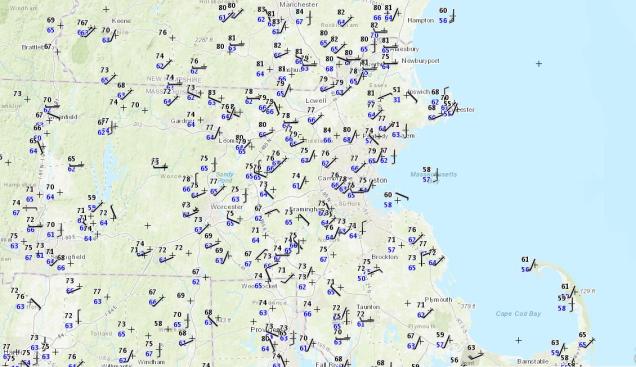
It’s a little humid for mid-May, but temperatures in the 70s to lower 80s at midday are pretty nice. Image provided by NOAA.
We’ve got a rather nice day in progress across the region, but changes are coming. At midday, temperatures are generally in the 70s to lower 80s away from the coastline, where seabreezes are keeping temperatures in the 50s to lower 60s. Dewpoints are creeping up, generally in the 60s now, which is humid by mid-May standards. We’ve also got plenty of sunshine, so temperatures should continue to climb into the afternoon. However, a cold front is starting to approach from the west. An area of showers and thunderstorms is moving into western Massachusetts at midday, and though these should weaken, they will spread cloud cover in, with some rain possible across northern Massachusetts and southern New Hampshire early this afternoon.
The HRRR simulates what the radar should look like as we head through the afternoon and evening. Loop provided by WeatherModels.com
As that cold front approaches, a stronger line of thunderstorms is expected ahead of it. As you can see in the radar simulation above, this line should enter our region during the 5-8pm time frame, also known as the evening rush hour. Some of these storms will contain strong winds, heavy downpours, and frequent lightning. That will likely make the commute home for many people even worse than normal.
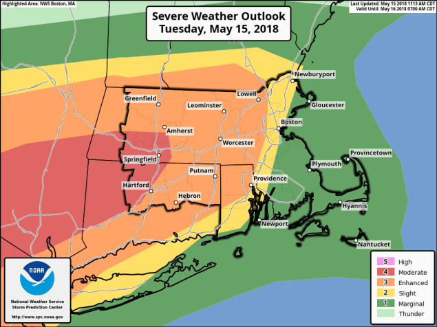
There is a moderate risk of severe weather across much of interior Southern New England this afternoon. Image provided by the Storm Prediction Center.
If it were just rain, wind, and lightning, it wouldn’t be a big deal. The problem is, it might be more than “just rain wind, and lightning.” Well away from the coastline, conditions will be favorable for severe thunderstorms to develop ahead of the front. As we mentioned in our Weekly Outlook, we still think the best odds for severe weather are from the Mid-Atlantic states into southeastern New York and western New England, but some severe storms could survive into eastern New England late this afternoon and evening. These storms should start to weaken quickly as they approach the coastal plain, but from interior Rhode Island into Central Massachusetts, the I-495 Belt of eastern Massachusetts, and Southern New Hampshire, we could see some fairly strong thunderstorms. We’ve already mentioned the frequent lightning and heavy downpours, but in the places we just mentioned, winds could gust to 60 mph or more with some of the stronger storms, which could result in more damage to places that already had lots of tree damage earlier this month.
There is a low chance for a tornado or two this afternoon with some of the stronger storms. Image provided by the National Weather Service.
In addition to the threats we listed in the last paragraph, there is also a low (but non-zero) threat for am isolated tornado or two this afternoon. No, we’re not expecting a tornado outbreak, but a brief tornado or two could spin up, especially across central and western portions of New England. In fact, if we do get one, it wouldn’t even be the first one this year in New England. Just last night, we found out that on May 4, a tornado tracked 35 miles through mostly (but not all) rural western and central New Hampshire.
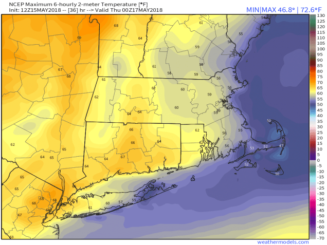
Temperatures on Wednesday will be 20-30 degrees cooler than today. Image provided by WeatherModels.com
Behind the front, Wednesday will be a much cooler day. Easterly winds and some cloud cover will keep temperatures in the 50s along the coast, lower 60s inland. Sunshine and warmer temperatures will return on Thursday, so you’ll only have one day to complain about.
Billy Joel was right – there’s a storm front coming. And going. And coming. And going. Actually, it’s more of a stationary front that will ripple north and south as waves of low pressure ride along it this week. When it heads north, we’ll be warm. When it heads south, we’ll be cooler. There will also be periods of showers and thunderstorms. Let’s see if we can sort of the timing of these waves.
A general west-to-east flow is expected across the Northeast this week, which is why we’re not expecting any big storms. We’ll just have waves of low pressure riding along a frontal boundary every few days, giving us some bouts of unsettled weather, Loop provided by Pivotal Weather.
We’ll start the week off with that front off to our south. However, it’s far enough to the south that we’ll get plenty of sunshine, so temperatures will actually be fairly mild. In fact, away from the coastline, temperatures should get into the 70s. By Tuesday, however, things change. Our first wave of low pressure heads toward the region. This will lift the front northward, bringing us warm and humid conditions, but also clouds, showers, and possibly some thunderstorms.
Some thunderstorms are possible on Tuesday, but the best chance for any severe weather will be off to our southwest – in the Mid-Atlantic states. Image provided by the Storm Prediction Center.
The showers may linger into Wednesday morning before the front slips southward again. That means Wednesday could be another cloudy and cool day across the region, with some sunshine possible in the afternoon. The front heads far enough southward again on Thursday to allow for plenty of sunshine and mild temperatures once again.
Thursday looks like the pick of the week right now. Sunshine and temperatures well into the 70s away from the coast, possibly even some lower 80s. Image provided by Weathermodels.com
This brings us to Friday. Another wave of low pressure will move towards the region from the west. However, clouds will stream in ahead of it, and this will keep temperatures on the cool side again. This wave will bring us showers late Friday into Saturday, some of which could be heavy. As the wave heads to our north and west on Saturday, it should lift that front northward again, allowing the milder air back in, despite the cloudcover and showers.
The big question now is – what does Sunday bring? Low pressure will pass well to our north and west, so it will eventually drag a cold front across the region. Right now, it looks like that cold front will hold off until Sunday night or even Monday. So, we should be fairly warm. We’re fairly confident in that. It’s the other part of the equation that we’re not so sure about. We could stay most cloudy with occasional showers and possibly a thunderstorm. We could also break out with some sunshine, and have a warm and humid day with a chance for a few showers and thunderstorms. At this point, we’ll lean towards the latter scenario, but if you’ve got any outdoor plans, just keep an eye on updated forecasts during the week.
Monday: Sunshine filtered through some afternoon high clouds, especially south of Boston. High 69-76, except 61-68 right along the South Coast and across Cape Cod.
Tuesday: Intervals of clouds and sunshine and breezy with a chance for showers and thunderstorms. High 76-83 inland, 68-75 along the South Coast and across Cape Cod.
Tuesday night: Mostly cloudy and breezy with scattered showers. Low 50-57.
Wednesday: Showers ending in the morning, mainly south of Boston, some sunshine develops in the afternoon, especially across southern NH and northern MA. High 57-64, coolest right along the east coast.
Thursday: Sunshine and some high clouds again. High 74-81, cooler along the South Coast and across Cape Cod.
Friday: Increasing clouds, showers possible late in the day, more likely at night. High 60-67, cooler right along the coastline.
Saturday: Cloudy and becoming breezy with showers likely. High 60-67.
Sunday: Partly sunny and breezy with a chance for showers and thunderstorms. High 70-77.
Satellite loop of the disturbance in the eastern Gulf of Mexico early Monday morning. Loop provided by NOAA.
Finally, even though hurricane season doesn’t start officially until June 1, we’ve got an area of disturbed weather in the Gulf of Mexico that is being watched for development. Right now, it’s a weak disturbance that is interacting with an upper-level low pressure system. It’ll drift northward over the next few days, bringing some heavy rain to Florida and parts of the Southeast. It could developing into tropical depression or a subtropical system, but that is not likely at this time. By late in the week, it should move inland over the eastern Gulf Coast, and the moisture should ride up the Appalachians. This could give us some heavier rainfall over the weekend and into early next week as that cold front moves through.
Now that we’re heading into the middle of May, we’re finally getting some typical Spring weather for New England. Nothing too extreme – some mild days, some cool days, some sunshine, some rain. No snow though – that *should* be done for the year.
May has started off on a very warm note across much of the Northeast. Temperatures over the next few days will be much closer to normal, even below normal for a day or two. Image provided by the Northeast Regional Climate Center.
The week starts off with high pressure building in on Monday, giving us sunshine and cool conditions. Tuesday should be a decent day as well, but there’s the potential for it to be not so great. Low pressure should remain south of the region, but it may be just far enough north to spread some clouds in, at least to the South Coast. If the high pressure area to the north builds in enough, we’ll stay sunny and start to warm up again. Wednesday should also be sunny and mild with high pressure in control.
By Thursday, things start to change again. A cold front will be approaching from the west. Clouds will stream in ahead of the front during the day on Thursday, with some showers likely late Thursday into early Friday as the front moves across the region. Neither day will be a washout, but you may need an umbrella, especially late Thursday and Thursday night if you’re heading out.
High pressure returns on Friday with cooler conditions once again. Mothers Day weekend is a big question mark at this point. Low pressure will head towards the region, with a warm front ahead of it, and a cold front behind it. The timing of these fronts is in doubt, which has significant implications on the forecast. One model brings the warm front through early Saturday, with a mild Saturday, (below left) and a very warm Sunday ahead of the cold front, with showers in the afternoon. Another model keeps Saturday quite chilly and damp (below right), with the warm front not moving through until early Sunday, and the cold front waiting until early Tuesday before it moves through. Based on our experience, the more likely scenario is the later timing. So, even though our forecast right now is for a chilly and damp Saturday, keep in mind that conditions could be significantly better than what we’re forecasting right now.
Saturday could be mild if the GFS is correct. Image provided by WeatherModels.com
Saturday could be chilly if the ECMWF is correct. Image provided by WeatherModels.com
Monday: Morning clouds gradually give way to partial sunshine. High 58-65, coolest along the coast.
Monday night: Becoming mostly clear. Low 41-48.
Tuesday: Partly to mostly sunny. High 63-70, coolest along the coast.
Tuesday night: Clear to partly cloudy. Low 42-49.
Wednesday: Sunshine and a few clouds. High 68-75.
Thursday: Increasing clouds, showers possible late in the day and at night. High 66-73.
Friday: Early clouds, then sunshine returns in the afternoon. High 65-72.
Saturday: Cloudy and cool with a chance of showers. High 53-60.
Sunday: Partly to mostly cloudy with a chance for more showers. High 63-70.


")

