As we head down the home stretch of 2016, we’ve got plenty going on in the weather department. In fact, we’re looking at three separate storms over the next seven days. So, let’s get right to it.
Storm #1 impacts the region later today into Tuesday. For the most part, this storm will not be a big deal, with some light rain for much of the region. However, when the precipitation moves in this afternoon, temperatures will be on the chilly side. We may see some flurries or sleet in a few spots, but it should all change to rain by mid-to-late afternoon. That’s good if you’re south of Boston. If you’re north and west of Boston, it’s bad, because temperatures will likely still be below freezing, meaning, we’re looking at some freezing drizzle or freezing rain for much of the afternoon. Warmer air will eventually spread northward, with temperatures rising above freezing as we head into the evening, but it may be close to midnight across central and southern New Hampshire before that happens. The rain ends by midday Tuesday, then we dry out for Wednesday, though it will remain on the chilly side. This brings us to Storm #2.

Storm #2 will impact the region Thursday, and there are still plenty of questions with this storm that we can’t answer definitively right now. What we do know is that a storm will move across the Great Lakes and into central Quebec. A secondary storm system will develop off the Mid-Atlantic coast and head northeastward. How quickly that secondary system develops and where it actually tracks will have a big impact on the forecast. Right now, it looks like most of our area will see mainly rain, with the best chance for some snow across areas north and west of Boston. The farther north and west you go, the better the chance for more snow.That storm heads into Atlantic Canada on Friday and really gets cranked up, which means we’re looking at a windy and cold day. A few flurries are even possible.High pressure builds in for Saturday, before Storm #3 comes calling on Sunday.
Storm #3 is the weakest of the bunch, but that doesn’t mean it won’t cause problems, especially since it’ll be New Year’s Day. The precipitation should start out as snow before daybreak, so if you’re out REALLY late on New Year’s Eve, you may have to watch out. However, it will likely change over to rain across much of the region before ending in the early afternoon hours.
As always, if any of these systems become a bigger threat, we’ll have a more detailed post in advance of it. Right now, the Thursday system is the one we’d be most concerned about that being the case.
Monday: Becoming cloudy with some spotty flurries or sleet around near midday, then some freezing drizzle or freezing rain likely in the afternoon, changing to plain rain across much of eastern Mass by evening. High 27-34 north and west of Boston, 34-41 south and east..
Monday night: Any remaining freezing rain across southern NH and the Merrimack Valley changes over to plain rain by midnight, with light rain and showers across the rest of the area. Becoming windy, especially across Cape Cod and southeastern Mass. Temperatures gradually rise overnight.
Tuesday: Showers ending in the morning, some clearing takes place in the afternoon. Breezy. High 48-55 before midday, then temperatures drop in the afternoon.
Tuesday night: Clear to partly cloudy, still breezy. Low 23-30.
Wednesday: Partly to mostly sunny. High 34-41.
Thursday:Becoming cloudy with rain likely, changing to snow across central/southern NH and into central MA, tapering off and ending late at night. High 37-44.
Friday: Intervals of clouds and sunshine, breezy, chance for a few snow showers. High 32-39.
New Year’s Eve:A mix of sun and clouds, still breezy. Light snow develops towards daybreak, except rain along the South Coast and across the Cape. High 26-33.
New Year’s Day: Cloudy with any snow changing over to light rain across the region, ending late in the day. High 36-43.
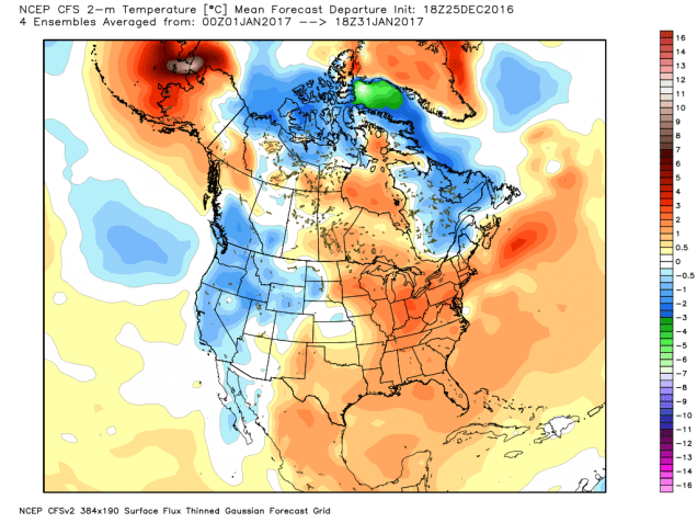
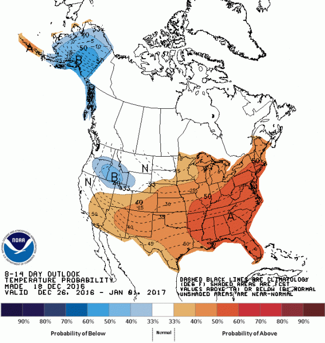
What will January bring? Well, at least one model says that temperatures will be above normal, with near normal precipitation. That likely means we wouldn’t see a lot of snow around here.