Hurricane Season 2020 Starts Monday

Earlier this month, Tropical Storm Arthur grazed the Outer Banks of North Carolina and “Tropical Storm Bertha” moved into South Carolina, marking the 6th year in a row that we had at least one named tropical system in the Atlantic before the “official” start of Hurricane Season, which runs from June 1 through November 30. That’s just the start of what looks to be an active hurricane season.

The list of Tropical Cyclone Names for the Atlantic for this season. Image provided by the National Hurricane Center.

Arthur produced wind gusts of up to 45 mph across the Outer Banks of North Carolina, with rainfall of 3-5 inches resulting in some flooding. Otherwise, it was a rather unremarkable storm, which is rather typical for early-season storms. Earlier this week, “Bertha” (we’re skeptical that it was really a tropical storm) brought heavy rain into parts of South Carolina. This is the 6th time since 1851 that we’ve had 2 named storms form before June 1 (1887, 1908, 1951, 2012, and 2016 are the others). Despite the early start for the past several years, the average date for the first named storm in the Atlantic is still in late June or early July. Over 97% of all named storms in the Atlantic form between June 1 and November 30. Like our first two storms this year, most early season storms tend to be on the weaker side. A hurricane hasn’t made landfall in the United States before July 1 since Hurricane Bonnie came ashore as a minimal hurricane near the Texas/Louisiana border on June 26, 1986.

Based on climatology, the most likely spots for an early season storm are in the Gulf of Mexico or northwest Caribbean. Image provided by the National Hurricane Center.

An early start is not always a harbinger of what the season will bring. NOAA issued their seasonal hurricane outlook last Wednesday, and it calls for a 60 percent chance for an above normal season, a 30 percent chance for a normal season, and a 10 percent chance for a below normal season. Many of the other hurricane outlooks issued by various outlets are also expecting a busy season, due to a number of factors. An average season consists of 12 named storms, of which 6 become hurricanes and 3 become major hurricanes (Category 3 or higher on the Saffir-Simpson scale). NOAA’s forecast for this season calls for 13-19 named storms, 6-10 hurricanes, and 3-6 major hurricanes. The Tropical Meteorology Project at Colorado State, the first group to forecast how active a hurricane season would be, originally led by Dr. Bill Gray, will issue their forecast on June 4. Their initial forecast from April called for 16 named storms, 8 hurricanes, and 4 major hurricanes. They also pegged the chance at a storm making landfall in the United States at 69% (52% is the average in any given year), and the odds of a storm making landfall along the East Coast at 45% (31% is the average). The last 5 seasons have all featured above normal activity across the Atlantic.

The 2019 Hurricane Season was an active one across the Atlantic Basin. Image provided by the National Hurricane Center.

A busy season does not always mean that multiple storms (or any storms for that matter) will impact the United States. In 2010, 19 named storms were observed in the Atlantic, 12 of them became hurricanes, and 5 were major hurricanes. Only one storm made landfall in the United States, and that was Bonnie, which was a minimal tropical storm at landfall. On the flip side, an inactive year doesn’t mean much for landfall probabilities as well. Only 7 named storms formed in 1992, and the 1st one didn’t develop until August 16. That storm, however, was named Andrew, and it made landfall just south of Miami as a category 5 storm.

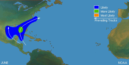
Here in New England, we should always pay attention when a storm is nearing the Bahamas, as those are the ones that have the potential to impact us, and we are very overdue for a system to impact us. Using data back to 1851, here are some stats that show how overdue we are:

  • Since 1851, 36 storms of tropical storm strength of greater have made landfall in New England or Long Island, an average of one every 4.7 years. The longest we’ve ever gone without one is 11 years, between 1897 and 1908 and also between 1923 and 1934. We’re at 9 years since Irene, the last one to do so.
  • Since 1851, 28 strong tropical storms (maximum sustained winds of 60 mph or more) have made landfall in New England or Long Island, an average of one every 6 years. The longest we’ve ever gone without one is 20 years, between 1991 and 2011. We’re at 9 years since Irene, the last one to do so.  
  • Since 1851, a hurricane has made landfall in New England or Long Island 18 times, an average of one every 9.4 years. The longest we’ve ever gone between hurricane landfalls is 38 years, between 1896 and 1934. It’s been 29 years since Bob, our 2nd longest drought on record.
  • Since 1851, 9 hurricanes of Category 2 intensity or stronger have made landfall in New England or Long Island, an average of one every 18.8 years. The longest we’ve gone between hits by storms of that intensity is 69 years, between 1869 and 1938. We’re at 29 years since Bob, the last one to do so.
  • Since 1851, New England/Long Island has had 3 Major Hurricanes (Category 3 or higher) make landfall – an unnamed storm in October of 1869, the infamous 1938 Long Island Express, and Hurricane Carol in 1954. That’s an average of 1 every 56.3 years, and the longest time between 2 major hurricanes is 69 years (1869-1938). We’re at 66 years since Carol. There are also 3 documented storms from before 1851 – The Great Colonial Hurricane of 1635, the 1815 New England Hurricane, and the Norfolk and Long Island Hurricane of 1821. That’s it. That changes the numbers to 6 in 385 years, or one every 64.2 years, with a longest drought of 180 years.
Satellite photo of Hurricane Bob approaching New England. Bob was the last hurricane to make landfall in New England – 27 years ago. Image provided by NOAA.

We all saw what Sandy did in 2012, and that was a minimal hurricane that eventually made landfall in southern New Jersey. When (not if) the next big storm comes up the coast, much of this region will not be prepared for the storm or its aftermath.

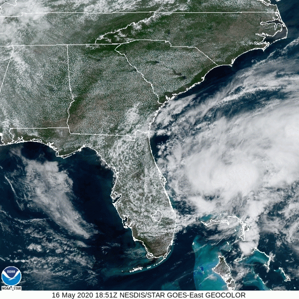
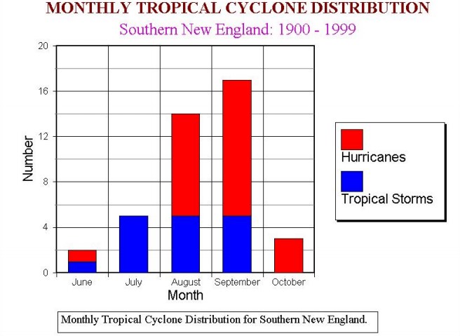
The Atlantic is quiet right now, but some of the models show the potential for a system to develop over the next 7-10 days in the western Caribbean or the Bay of Campeche (we’re ignoring the cluster of cumulus clouds in the central Atlantic that the National Hurricane Center is “watching”). Even if something were to form off the East Coast in the next few weeks and head this way, the waters off of New England are much too cold to sustain a tropical system, so we’d see something more like a typical nor’easter. Only two tropical storms have ever made landfall in the Northeast before the end of June. The first was an unnamed minimal tropical storm that crossed extreme eastern Long Island and went into southeastern Connecticut on May 30, 1908. The other was Tropical Storm Agnes, which made landfall near New York City on June 22, 1972, then caused devastating flooding across parts of the Mid-Atlantic states. In terms of hurricanes, the earliest one to ever make landfall up this way was Hurricane Belle, which slammed into Long Island with 90 mph winds on August 9, 1976. We did have Hurricane Arthur pass just offshore of Nantucket on July 4, 2014. While it did not make landfall, it made for a rather wet and cool holiday, especially across Cape Cod and southeastern Massachusetts. Statistically, the most likely time for a hurricane to hit New England is between the middle of August and late September. Of the 18 hurricanes that made landfall in New England or Long Island since 1851, 16 of them have done so between August 19 and September 27.

The most likely time for a tropical system to impact our area is August of September. Image provided by the National Weather Service office in Norton, MA.

As always, you should get your weather information from a trusted source, especially when dealing with tropical systems. Much like with snowstorms in the winter, there will be plenty of hype and exaggeration on Twitter and Facebook, as well as people posting doom and gloom maps showing how a thunderstorm near the coast of Africa will develop into a Category 5 storm and head right for the East Coast in the next 2 weeks. We’re not among that group, we give you facts and our best forecasts, without any hype. If there’s reason to worry, we’ll let you know with plenty of advance warning. It’s always best to prepare ahead of the season. Chances are, you won’t have anything to worry about, but in case you do, it’s always good to be prepared, as we’ve learned recently.

Weekend Outlook: May 28-June 1, 2020

Changes are coming over the next few days. We’ve been dry for a while, but some rain is in the future. It’s been warm for much of the week, but cooler weather is on the horizon.

Despite plenty of cloudcover, it’s a warm afternoon across most of the region. Loop provided by NOAA.

We start off with high pressure still in control this afternoon and evening. A southerly flow around the offshore high pressure system continues to bring warm and humid air into southern New England. It’s also bringing plenty of cloudcover in. Aside from a few sprinkles here and there, it should remain dry through the afternoon. Low clouds and fog will move back in tonight, especially along the south coast, as the warm and humid air continues to flow into the region.

A cold front will start to move in from the west on Friday. Much of the day will be similar to today with plenty of clouds along with some warm and humid air. We could see a few showers around in the morning, but they’ll be light for the most part and very widely scattered. In the afternoon, as the cold front starts to get closer, strong to severe thunderstorms will likely start to develop across portions of New York down into the Mid-Atlantic states. These storms will move eastward, but once we get into the evening, they’ll start to weaken as they lose the heating of the sun. They move across our area overnight and early Saturday. For the most part, we’re just looking at scattered showers, with some embedded thunder and lightning, and a few heavy downpours.

Strong to severe storms are possible across parts of the Northeast on Friday, but the bulk of the severe weather should stay to our west. Image provided by Pivotal Weather.

The showers should come to an end by midday Saturday as the front finally pushes across the region, then drier air will start to move in. Skies should start to clear our late Saturday and Saturday night as high pressure builds in from Canada. Cooler air will start to settle in on Sunday despite plenty of sunshine. By Monday, an upper-level trough of low-pressure will be moving across the region, so we’ll see some additional clouds and possibly a few showers, but also even cooler conditions are expected.

Away from the South Coast very little rain has fallen over the past week, so we need all that we can get. Image provided by Weathermodels.com

Tonight: Mostly cloudy with some patchy fog, especially along the South Coast. Low 62-69.

Friday: Mostly cloudy and breezy with a few showers possible. High 72-79 south of the Mass Pike, 80-87 north of the Pike.

Friday night: Cloudy with showers likely, possibly some thunder. Low 60-67.

Saturday: Cloudy with showers ending by midday, some clearing takes place in the afternoon, especially north and west of Boston. High 77-84, cooler along the South Coast.

Saturday night: Becoming mostly clear. Low 54-61.

Sunday: Mostly sunny, cooler, and less humid. High 68-75.

Sunday night: Clear skies and cool. Low 44-51.

Monday: A mix of sun and clouds, chance for a few afternoon showers. High 61-68.

Weekly Outlook: May 25-June 1, 2020

Memorial Day is the “traditional start of summer”, and we’ll certainly have some summer-like weather this week, just not on Memorial Day.

The forecast for this week is actually fairly simple. We start the week out with plenty of low clouds and some fog for your Memorial Day morning. With high pressure east of Nova Scotia and low pressure south of New England, a light southeast flow is bringing in plenty of moisture in the form of cloud cover. Some patchy drizzle is possible along the coast as well. As we head into the afternoon, the clouds will start to break up away from the coast, allowing for some sunshine, but the low clouds and fog/drizzle may hang tough along the coast. The cloudcover, combined with winds blowing off the still-chilly Atlantic, will keep temperatures well below normal along the coast, but inland, temperatures will be much warmer, especially where sunshine develops. The low clouds and fog return Monday night, but things start to change in a big way on Tuesday.

The nighttime microphysics image from the GOES satellite shows the low clouds and fog spread across eastern Massachusetts Sunday evening and night. Loop provided by NOAA.

By Tuesday, high pressure will settle southward, with more of a south to southwest flow developing across the Northeast, this will allow warmer air to start to move in. Temperatures should jump into the 70s and lower 80s, but coastal locations, especially ones facing south, will stall cooler. Wednesday should feature even warmer weather. By Thursday, you’ll start to notice an increase in humidity, with a few pop-up showers possible in the afternoon.

Temperatures could approach 90 well inland on Wednesday. Image provided by WeatherBell.

As we head into Friday, a cold front will be approaching the region. This will bring in more cloudcover, with showers and thunderstorms expected, especially during the afternoon and evening. How much sunshine we get and when the front actually moves through will determine how warm we’ll get and how strong the storms will be. We’ll have more clarity on that situation on Thursday in our Weekend Outlook. Behind the front, high pressure builds in for the weekend with drier conditions.

Dewpoints could get into the middle to upper 60s across the region ahead of the cold front on Friday. Image provided by Weathermodels.com

Memorial Day: Low clouds and fog along with some patchy drizzle during the morning, then skies become partly sunny away from the coast in the afternoon. Some sunny breaks may develop along the coast late in the day. High 64-71, except 56-63 right along the coast.

Monday night: Low clouds and fog return. Low 50-57.

Tuesday: Becoming partly to mostly sunny. High 79-86, cooler along the coast.

Tuesday night: Clear to partly cloudy during the evening, low clouds and fog may move back in, especially along the coast. Low 56-63.

Wednesday: Partly to mostly sunny. High 83-90, cooler along the coast.

Thursday: Sunshine filtered through some high clouds, breezy, more humid, chance for a pop-up shower or thunderstorm in the afternoon. High 82-89, much cooler along the coast.

Friday: Partly to mostly cloudy, breezy, and humid with showers and thunderstorms likely during the late afternoon and evening. High 76-83.

Saturday: Becoming partly to mostly sunny. High 72-79.

Sunday: A mix of sun and clouds. High 68-75.

Weekend Outlook: May 21-25, 2020

Memorial Day weekend has arrived, and although the weather won’t be ideal, it could be a lot worse.

There weren’t many clouds across the region today, and Friday will be similar. Loop provided by NOAA.

High pressure remains in control on Friday, and it should result in probably the best day of the year thus far. We’ll have sunshine and temperatures getting into 80s away from the South Coast. Some clouds will start to move in during the afternoon though, the first sign of a significant change for Saturday.

Low pressure will pass south of the region on Saturday, with some showers likely along the South Coast, possibly as far north as the Mass Pike. For the rest of us, we’ll see plenty of clods, though there still may be some sunshine across parts of southern New Hampshire. The more noticeable effect will be on temperatures., With winds shifting into the east and northeast and blowing off of the still-cool Atlantic, temperatures will be 15-25 degrees cooler on Saturday compared to Friday.

Temperatures Saturday afternoon will be 20-25 degrees colder than at the same time Friday afternoon. Image provided by WeatherBell.

The system pulls away on Sunday and high pressure builds back in with sunshine returning, but temperatures will remain quite chilly for late May thanks to a wind off the water. We’ll start to moderate on Monday with high pressure still in control. Beyond that, it’s looking significantly warmer for the middle to end of next week, but we’ll get into more detail on that in our weekly outlook early Monday morning.

Warmer weather is expected across the Northeast for the end of next week. Image provided by the Climate Prediction Center.

Tonight: Clear to partly cloudy. Low 45-52.

Friday: Sunshine starts to fade behind increasing high clouds late in the day. High 78-85, cooler along the South Coast.

Friday night: Becoming mostly cloudy with showers developing after midnight across the South Coast. Low 52-59.

Saturday: Mostly cloudy and breezy with showers likely south of the Mass Pike, ending in the afternoon. Some sunny breaks may develop across southern New Hampshire during the afternoon, and skies may start to clear out late in the day north of Boston. High 63-70, but temperatures may drop during the afternoon, especially along the coast.

Saturday night: Becoming mostly clear. Low 40-47.

Sunday: Sunshine and some high clouds. High 60-67, cooler along the coast.

Sunday night: Partly cloudy, some patchy fog may develop. Low 40-47.

Memorial Day: A mix of sun and clouds. High 67-74, cooler along the coast.

Weekly Outlook: May 18-25, 2020

If we had written this forecast a few days ago, it would have looked rather cool and damp for a large chunk of the week. Instead, it’s now looking a lot drier, and likely a bit milder, especially late in the week.

We start the week off with a warm front trying to move into the region, producing a few light showers this morning , mainly north of the Mass Pike. The front won’t quite make it, so we’ll remain on the cool side, with plenty of clouds. The reason the front won’t make it is a large area of high pressure over eastern Quebec is going to slowly build in and drop southward. As the high builds in, we’ll start to clear out for Tuesday, with another cool day expected, especially along the coast.

Normal high temperatures are in the upper 60s to near 70 in mid-to-late May. Image provided by Weathermodels.com

As we had into the middle to latter portions of the week, that high pressure area will continue to slide southward and offshore, with winds shifting into the west and southwest. This will bring milder air back in, especially by Friday, when temperatures could top 80 degrees in spots.

By Friday night, a weak area of low pressure over the Mid-Atlantic states will start to push offshore south of New England. This will bring clouds back in along with a few showers. The more noticeable effect will be on temperatures, as winds will shift back into the east, bringing much cooler air back in off the chilly Atlantic. We’ll dry out Saturday night and Sunday as the low pulls away. High pressure should build back in for Memorial Day, with warmer weather returning.

At least one model is forecasting a rather warm Memorial Day. Image provided by WeatherBell.

Monday: Plenty of clouds, chance for a few showers in the morning, mainly north of the Mass Pike. High 60-67, cooler along the coast.

Monday night: Partly to mostly cloudy. Low 41-48.

Tuesday: A mix of sun and clouds, breezy. High 55-62, coolest along the coast.

Tuesday night: Becoming mostly clear. Low 38-45.

Wednesday: Plenty of sunshine. High 59-66, a little cooler along the coast.

Thursday: Sunshine and a few afternoon clouds. High 67-74, cooler along the South Coast.

Friday: Partly to mostly sunny. High 73-80, cooler along the South Coast.

Saturday: Intervals of clouds and sunshine, breezy, chance for a few showers. High 68-75, but temperatures may turn cooler in the afternoon, especially along the coast.

Sunday: Partly sunny. High 63-70, cooler along the coast.

Memorial Day: A mix of sun and clouds. High 70-77, cooler along the coast.

Tropical Storm Arthur will bring some rain and gusty winds to the Outer Banks of North Carolina today. Loop provided by NOAA.

Tropical Storm Arthur remains fairly weak off the Southeast coast early this morning. It will brush the Outer Banks of North Carolina later today with some gusty winds and heavy rainfall, but is expected to turn more toward the northeast and east and head out to sea while becoming extratropical on Tuesday. It may bring some gusty winds and rainfall to Bermuda later this week as an extra tropical system. After that, it may actually meander around in the central Atlantic for several days as an extratropical system, but won’t impact any land areas.

Another Early Start to Hurricane Season

For several days, most of the forecast models have been showing the potential for a tropical or subtropical system to develop in or near the Bahamas this weekend. Potential became reality Saturday evening when Tropical Depression One formed.

Satellite loop showing newly-formed Tropical Depression One. Loop provided by NOAA.

As of 8pm EDT, newly-formed Tropical Depression One was centered about 175 miles east-northeast of Melbourne, Florida, moving toward the northeast at 14 mph. Maximum sustained winds were near 35 mph. With favorable upper-level conditions and the system sitting over the warm waters of the Gulf Stream, strengthening is expected, and the system will likely be upgraded to Tropical Storm Arthur tonight or on Sunday.

Forecast track for Tropical Depression One. Image provided by the National Hurricane Center.

A general north-to-northeast track is expected over the next few days, which could bring the center very close to the Outer Banks of North Carolina on Monday. As a result, a Tropical Storm Watch is now in effect for the coast of North Carolina from Surf City to Duck, including Pamlico and Albemarle Sounds.

Rain and gusty winds across the northwestern Bahamas and the east coast of Florida will wind down tonight, but rain should spread into the Carolinas later Sunday. The heaviest rain is expected from eastern North Carolina into the Delmarva Peninsula Monday into Tuesday, where as much as 2-4 inches could fall, leading to some localized flooding.

Rainfall forecast through Tuesday morning from the GFS. Image provided by WeatherBell.

Once it gets past the Carolinas, the official forecast track from the National Hurricane Center calls for the storm to turn toward the east-northeast and head out to sea while becoming extratropical, but this is far from a lock. An upper-level low pressure system will be moving into the Mid-Atlantic states and some models show the potential for the upper-low to capture the storm, and let it meander around near or just off the East Coast for several days as an extratropical system, with a large high pressure area to the north blocking it from moving farther up the coast. This would result in several days of damp and breezy conditions from the Carolinas possibly into Southern New England. Once we get towards Monday, we should hopefully have a better idea of what the storm will do.

While Hurricane Season in the Eastern Pacific Ocean starts on May 15, Hurricane Season in the Atlantic Basin does not officially start until June 1. However, as we’ve seen already several times, Mother Nature keeps her own calendar. This is actually the 6th year in a row that we’ve had a tropical system develop in the Atlantic Basin before June 1.

While Tropical Depression One will grab the weather headlines, it’s not the only tropical system that is active in the world right now. A much bigger threat has developed in the Bay of Bengal. Tropical Cyclone 01B (Amphan – pronounced UM-PUN) developed early Saturday, and is already strengthening quickly. As of late Saturday afternoon, the storm has maximum sustained winds near 50 mph, and is expected to continue strengthening rapidly while heading off towards the north. Current forecasts have the storm making landfall in either Bangladesh or extreme eastern India by Tuesday or Wednesday. By that point, maximum sustained winds could be in excess of 110 mph.

Forecast track for Tropical Cyclone 01B (Amphan). Image provided the India Meteorological Department

Strong winds would obviously be a significant hazard, but history has shown several times that the biggest threat with tropical cyclones in that part of the world is flooding, both from storm surge and torrential rainfall. Much of that region lies near sea-level and is very densely populated. In the past, storms that hit this area have resulted in tens of thousands, if not hundreds of thousands, of deaths. Given what is already going on around the world, this would make the situation exponentially worse.

Weekend Outlook: May 14-18, 2020

Now that the warmer weather has finally arrived, we’re going to start issuing a Weekend Outlook on Thursdays, in addition to our Weekly Outlook that gets issued early Monday morning. This coming weekend will be better than a lot of the ones we’ve had recently, but it’s not all sunshine and mild temperatures.

The high pressure system giving us a rather nice day today will slide offshore and clouds will start to increase as we head through the afternoon. Low pressure moving into the Midwest will send a warm front our way tonight and Friday. A period of showers with some embedded heavier and steadier rain is likely tonight, mainly after midnight, as the warm front moves across the region, with most of the rain moving offshore around or a little after daybreak. This sets up a challenging forecast for Friday.

The high-resolution NAM model shows the rain, some of it heavy, moving across the region late tonight. Loop provided by WeatherBell.

That warm front will bring much milder air into the region on Friday, with many locations likely jumping into the 70s. This brings us to forecast dilemma #1 – how far north does the warm front get before it stalls out? Right now, we’re thinking that most of the region will break into the warm air, with the exception of southern Maine, the New Hampshire Seacoast, and possibly extreme northeastern Massachusetts (i.e. Salisbury Beach/Newburyport area). In those areas, temperatures may stay in the 50s or lower 60s. This front will eventually start sagging back southward as a backdoor cold front later in the day, allowing cooler air to move back into eastern areas late in the day.

Friday looks like it will have a very mild afternoon across much of the region. Image provided by Weathermodels.com

Now we get to forecast dilemma #2 – how much sunshine develops in the warm sector? This will be key for a couple of reasons. Obviously, the more sunshine we get, the warmer it will get, possibly allowing some locations well inland to get to 80. However, the other reason it’s important is that we’ll have a cold front moving in from the west, triggering showers and thunderstorms. The more sunshine and heating we get, the more unstable the atmosphere can become, and the stronger the storms we could see. We think that the best chance for any severe weather will be from the Connecticut Valley into eastern New York, but a few stronger storms could make it farther east. Some of these storms could produce heavy downpours and strong winds, with hail also a possibility. There’s also a chance for a tornado or two, mainly across western New England.

There is an enhanced risk of severe weather across much of central and western Southern New England on Friday. Image provided by the Storm Prediction Center.

The cold front moving in from the west will bring cool air back into much of the region Friday night. High pressure then builds in on Saturday with sunshine and seasonably mild temperatures through at least midday. However, the afternoon will be a different story. It appears as though another backdoor cold front is going to drop down the coast. This will bring in clouds and much cooler conditions once again. We’ll jump into the 60s or lower 70s by lunch time, but by late afternoon, we’ll be back in the 50s, with some upper 40s the closer to the coast you get.

The high-resolution NAM model shows temperatures warm up Saturday morning before the colder air forces its way back in during the afternoon. Loop provided by WeatherBell.

High pressure slides offshore on Sunday, with winds shifting back into the south, so we’ll start to warm up again, but like Saturday, temperatures will start to drop again in the afternoon as winds shift onshore. We’ll also have clouds start to stream in ahead of another storm system moving in from the west. This brings us to Monday, when things really go downhill again. Low pressure will be heading towards the Mid-Atlantic states, while a tropical or subtropical disturbance starts to take shape near or north of the Bahamas. The initial storm will bring us some rain on Monday, with gusty easterly winds keeping temperatures in the 50s, maybe even upper 40s. Yeah, we’re back to that nonsense. Monday is going to be a miserable day. Beyond that, we’ll have to see how the Mid-Atlantic system and the offshore system evolve, but there’s a decent chance that Tuesday won’t be much better, and possibly Wednesday as well, especially along the coast. We’ll get into more detail on that in our Weekly Outlook early Monday morning.

This Afternoon: Sunshine starts to dim behind increasing high clouds. High 64-71, coolest along the South Coast.

Tonight: Thickening clouds with a period of rain likely after midnight. Low 45-52.

Friday: Any showers end early, then becoming partly sunny. Clouds move back in late in the day. High 70-77, cooler across the South Coast, Cape Cod, and also the New Hampshire Seacoast.

Friday night: Showers and thunderstorms likely during the evening, then skies start to clear out late at night. Low 45-52 across southern New Hampshire and northeastern Massachusetts, 52-59 across southeastern Massachusetts and Rhode Island.

Saturday: Sunshine in the morning, clouds return to coastal areas in the afternoon. High 64-71, cooler along the coast. Temperatures quickly drop in the afternoon.

Saturday night: Partly to mostly cloudy. Low 42-49.

Sunday: Some sunshine in the morning, clouds return in the afternoon. High 61-68, cooler along the coast.

Sunday night: Cloudy with rain developing. Low 43-50.

Monday: Breezy and cool with periods of rain. High 51-58.

Weekly Outlook: May 11-17, 2020

We are finally ready to type the phrase you’ve all been waiting months to read – “Winter is over.”. We are done with snow until at least October, probably even later than that. Temperatures should finally start feeling like Spring as well. That doesn’t mean this week will be all sunshine and warm days.

We start the week off with low pressure heading out of the Great Lakes and towards New England today. It will send a warm front across the region this morning, with some showers likely. Once they move out, we’ll see some sunshine develop allowing temperatures to get fairly mild. However, a cold front will be approaching from the west and it will produce some showers and thunderstorms by late afternoon. A few of these storms may get quite strong, especially across the interior, with gusty winds and heavy downpours possible. With very cold air still in place aloft, we could also see some hail with any stronger storms that develop.

There is a marginal risk for severe thunderstorms across most of the region today. Image provided by the Storm Prediction Center.

Everything moves offshore during the evening and then high pressure builds in with clearing Monday night. This will bring some chilly air back in for Tuesday and Wednesday. An upper-level low moves through on Tuesday, producing some afternoon clouds and possible a few sprinkles. Skies will clear out Tuesday night as the high really settles in, and we could be looking at record low temperatures Wednesday morning with frost likely for much of the region. We’ll remain on the chilly side (relative to May) on Wednesday.

Record low temperatures could be broken across parts of the region Wednesday morning. Image provided by Weathermodels.com

The high slides offshore on Thursday, with temperatures starting to warm up once again. We may start to see some clouds stream in late in the day ahead of the next system moving into the Great Lakes. The system will send a warm front across the region Thursday night, with another round of showers expected. As the system passes to the north, we’ll see much warmer air move in on Friday, with gusty winds winds and some sunshine allowing temperatures to rise into the 70s. However, another cold front moves through late in the day, with more showers or thunderstorms possible.

Right now, Friday looks like it will be quite warm. Image provided by WeatherBell.

This brings us to next weekend, where there is plenty of uncertainty in the forecast. High pressure builds in on Saturday with dry weather, and temperatures may remain warm. However, as that high slides off into Atlantic Canada, it will send a backdoor cold front down the coast Saturday night and into Sunday. Sunday could still end up a decent day well inland (say from the Connecticut Valley westward), but the closer you are to the coast, the more likely you’ll experience east to northeast winds, possibly some drizzle and/or fog, and temperatures in the 50s (or even 40s) during the afternoon. Beyond that, there are some signals that temperatures could be on the warm side for at least a few days next week.

The latest 8-14 day outlook, valid for next week, has temperatures near to a little above normal around here. Image provided by the Climate Prediction Center

Monday: Morning clouds and showers, then becoming partly sunny and breezy. High 57-64.

Monday night: Clearing. Low 35-42.

Tuesday: Morning sunshine, afternoon clouds, possibly a sprinkle, breezy. High 49-56.

Tuesday night: Clear and chilly. Low 31-38.

Wednesday: Sunshine and a few afternoon clouds, still breezy. High 52-59.

Thursday: Plenty of sunshine, but some high clouds may start to stream in during the afternoon. High 59-66.

Friday: Morning showers, then becoming partly sunny, breezy, and warm. High 70-77, cooler right along the South Coast, and possibly along the NH Seacoast.

Saturday: Partly to mostly sunny. High 64-71, cooler along the coast.

Sunday: Partly sunny, low clouds, drizzle, and fog possible along the coast. High 50-57 along the coast, 58-65 inland.

A Chilly Weekend is Coming, a Little Snow too?

By now, you’ve heard the TV meteorologists talking about how it’s going to snow, or you’ve read the headlines about an “historic May snowstorm” that’s coming. As usual, we at Storm HQ will avoid the hype and just give you the facts. Yes, there will be some snowflakes around here and no, it won’t be a big deal at all.

A cold front is moving across the Great Lakes this afternoon, and it move across our area tonight, with plenty of clouds and possibly a few showers. Behind that front, much colder air will start to move into the region. This is an anomalously cold airmass for early May, and in fact, is more representative of early March. That front is expected to stall out near the South Coast, and then a wave of low pressure will develop along the front and ride along it, crossing southern New England Friday night and early Saturday.

The ECMWF model shows the progression of the system for Friday into Saturday. Loop provided by Pivotal Weather.

We’ll have some rain moving in Friday afternoon and evening, but as the sun sets and temperatures drop, some wet snow will start to mix in. The most likely spots for snow are in the hilly terrain from northern Rhode Island across Worcester County and into the Monadnocks of southwestern New Hampshire, as well as out in the Berkshires. However, we wouldn’t be surprised if there was some wet snow mixed in with the rain even into the suburbs of Boston.

As we mentioned with the last few storms, it’s awfully tough to get accumulating snow into early May for a variety of reasons. For one, the ground is fairly mild. Any accumulations will be mainly on grassy surfaces, as pavement temperatures are much too warm now. Secondly, temperatures may not even drop to freezing, but could stay in the middle to upper 30s. Third, the intensity of the precipitation will be key. Heavier precipitation will bring down colder air from aloft, resulting in the change to snow, whereas light precipitation will tend towards more rain.

As far as accumulations, as we said, we’re not expecting this to be a big deal for most of us. You may wake up Saturday morning, if you’re up early enough, to see a little bit of a coating on grassy surfaces, decks, and car roofs/windshields. As we mentioned, most of the accumulations will be confined to the hilly terrain, where a few inches could fall.

Snow is fairly rare once you get into May. Using data for Lowell, snow has been recorded 5 times during the month of May over the past 92 years, and measurable snow only twice.

5/11/1945 – Trace
5/1/1953 – Trace
5/10/1977 – 2.6″
5/6/1996 – Trace
5/18/2002 – 1.0″

The ECMWF model is closest to our thinking for snowfall with this storm. Image provided by WeatherBell.

The snow is only part of the story though, and in fact, a minor part. As the storm intensifies while pulling away on Saturday, gusty winds are expected across the area. West winds of 15-25 mph with gusts of 40-50 mph are expected, especially along the coast. At the same time, an upper-level low pressure area will be moving into the region, bringing in very cold weather. That upper low may trigger a few rain or snow showers in the afternoon, but the cold temperatures will be the story. High temperatures likely will stay in the 40s, which may set records for the lowest high temperatures for the date in many locations.

Record low high temperatures are possible across parts of the region on Saturday. Image provided by Weathermodels.com

The really cold weather will be short-lived, as we will start to moderate on Mother’s Day as high pressure builds in. However, if you’re hoping for some sustained warmth, it’s not coming anytime soon. There are some hints that we may get out of the pattern that’s kept us quite chilly for most of April and early May in another 10 days or so, but a “warm” pattern is still a ways off.

Temperature forecast for the next 45 days for Bedford, Massachusetts based on the 51 members of the ECMWF Ensemble forecast. Image provided by Weathermodels.com

The image above is the high and low temperature forecast for Bedford for the next 45 days, based on the ECMWF Ensemble, which has 51 separate members. The solid red and blue lines in the middle of each graph are the “normal” highs/lows for each day. The green dot is the average of the 51 members for each day (which is also represented numerically in the middle of the 2 charts), and the shaded gray area is the area that between 1/4 and 3/4 of the members fall. The horizontal blue lines above and below that are the extreme on each day. As you can see, this model is forecasting temperatures to remain well below normal through May 14-15. After that, temperatures generally average near or a little below normal until June 9. Granted, “normal” for those dates is upper 60s to near 70 for high temperatures, so it’ll be milder, but still a little cooler than we should be. Finally, we get to near or a little above normal for a sustained period around June 10. Now this is just one model, so take it with a grain of salt, but it’s done fairly well diagnosing the general details of our weather pattern for several weeks now. There is hope that you can finally take your summer clothes out of storage, perhaps as early as next weekend.

Weekly Outlook: May 4-10, 2020

The weather really was fantastic this weekend, wasn’t it? Spring has finally arrived! Hope you enjoyed it, because you won’t see it again for a while, certainly not this week.

Temperatures reached the 70s away from the South Coast on Sunday, with a few spots reaching 80 for the 1st time this year. Image provided by Weathermodels.com

We’ll start the week off with what will probably be the best day of the week, certainly the warmest. It won’t be as warm as the weekend, but temperatures will still be close to normal for early May. The problem is, we’ll have a cold front moving through, with some clouds, and maybe a shower or two. Gusty northwest winds behind the front will usher some cooler air into the region. Winds will start to die down on Tuesday as high pressure builds in, but temperatures will be noticeably cooler.

Clouds return on Wednesday as another system moves into the Mid-Atlantic states. This system will pass south of the region Wednesday night into early Thursday, likely producing some showers. Another shot of colder air settles in behind that system as an upper-level low pressure area drops southward from Canada. This sets us up for a very chilly end of the week and weekend.

Some frost is possible in the suburbs Saturday morning. Keep that in mind if you’ve got some things planted outside already. Image provided by WeatherBell.

As the upper-level low settles in, a weak disturbance rotating around it will move in on Friday, with plenty of clouds, a few showers, and unseasonably chilly temperatures. Another low pressure area will then move off the Mid-Atlantic coast and head northeastward, passing south and east of the region late Saturday into early Sunday. This will bring in some more rain, but that might not be all. The airmass moving in for the weekend is one that is more typical of early March than early May. Daytime highs may not reach 50, and the rain will make it feel that much worse. At night, as temperatures drop, there’s even a chance that some wet snow could mix in, especially across the hills of Worcester County and Northern Rhode Island. While this is highly unusual, it is not unprecedented. On May 9, 1977, a late-season storm produced snow across a large portion of southern New England, away from the coastline, with 1-2 feet in the hills of Worcester County. We also had up to 1″ of snow in some of the northwestern suburbs of Boston on May 18, 2002.

A late-season storm brought heavy snow to the region on May 9, 1977. Image provided by Tomer Burg.

The system pulls away early Sunday, then high pressure builds back in with clearing and chilly conditions for Sunday afternoon. Unfortunately, it looks like the cool pattern will continue into the following week. In fact, we may not see any sustained warmth until we get past the middle of May. We know that’s not what you want to hear, but it’s how we see things right now.

Monday: Intervals of clouds and sunshine, breezy, chance for a few showers, favoring the South Coast in the morning. High 60-67.

Monday night: Clearing, breezy. Low 34-41.

Tuesday: Sunshine and a few clouds. High 52-59.

Tuesday night: Clear to partly cloudy. Low 34-41.

Wednesday: Partly to mostly cloudy, showers develop at night. High 53-60, coolest along the coast.

Thursday: Plenty of clouds with showers likely, especially during the morning. High 50-57, coolest along the coast.

Friday: Early sun, then some afternoon clouds, breezy. High 52-59.

Saturday: Mostly cloudy with showers likely, possibly mixed with some wet snow across the hills of Worcester County and northern Rhode Island. High 45-52.

Sunday: Partly sunny and breezy. High 46-53.