Weekly Outlook: December 31, 2018-January 6, 2019

Remember last week when we hinted that First Night could be really cold? Well, it seems as though we were wr….wro….wro….we were a little off.

It is NOT going to be a fun First Night in the Dakotas. Image provided by Weathermodels.com

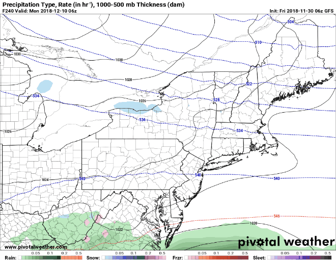
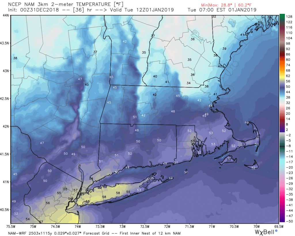
First Night is actually going to be bitterly cold, if you’re planning on spending it in Fargo, where wind chills will be 25 to 35 degrees below zero when the clock strikes midnight. Around here? It’ll be a tad milder. Low pressure will move from the Great Lakes into northern New England later today and tonight. Precipitation will move in this evening, and it will likely still be cold enough for some snow, sleet, or freezing rain from the Merrimack Valley northward, at least at the start. Elsewhere, just some rain is expected. Milder air will move in aloft, and eventually at the surface too, changing the precipitation to rain everywhere overnight. That warm air may take its time moving in, especially from the Merrimack Valley into southern New Hampshire, but New Years Morning will likely be quite mild across much of the area. Don’t get used to it, as a cold front moves through during the morning, with windy and colder conditions likely for the afternoon.

The NAM model shows cold air stubbornly hanging around in southern NH and the Merrimack Valley Tuesday morning, while everywhere else turns milder. Image provided by WeatherBell.

Tuesday afternoon is also when the Winter Classic takes places, featuring two of the absolute best sweaters in the NHL (and two of our favorite teams here at StormHQ) – the Boston Bruins and the Chicago Blackhawks. We’ll refrain from comment about the fact that it’s taking place at the home of the Angry Leprechauns – Notre Lame, er, Dame, or that outdoor hockey games are much better on TV than in person (trust us, we’ve experienced it), but for the game itself, it should be cloudy with temperatures in the middle 30s, which is pretty much perfect for outdoor hockey.

We’re not fans of outdoor hockey games, but we are fans of the Bruins and the Blackhawks. The weather will cooperate, so let’s hope for a great game (and a Bruins victory). Image provided by the National Hockey League.

As we head deeper into 2019, things get quieter (and colder) around here for a few days. High pressure builds in, and we’ll have generally dry and cool conditions for much of the remainder of the week, as we remain in a split jet-stream pattern. Basically, we’ve got a northern stream keeping some storms across southern Canada and to our north, and a southern stream keeping the warmer, juicier storms to our south. This will be the case on Friday when it looks like a southern stream storm will come along and give us some rain, while the northern stream remains locked up in Canada. If you don’t like snowstorms, then you want this pattern to continue. Why? Because if the streams cross, to quote Dr. Egon Spengler, “It would be bad.” That’s usually how we end up with some of our bigger snowstorms in the winter. As the storm moves by, colder air will work in behind it, with the rain possibly changing over to snow before ending on Saturday. High pressure then returns for next Sunday.

New Years Eve: Becoming mostly cloudy. High 37-44.

Monday Night: Cloudy and becoming breezy with rain developing, starting as some snow or a wintry mix from the Merrimack Valley into southern New Hampshire. Rain ends towards daybreak. Low 32-39 during the evening, then temperatures will hold steady or slowly rise overnight.

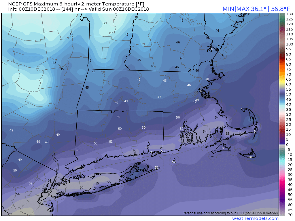
New Years Day: A lingering shower early, then becoming partly to mostly sunny, windy, and colder. High 49-56 in the morning then temperatures quickly drop through the 40s during the afternoon.

Tuesday night: Clear to partly cloudy. Low 18-25.

Wednesday: Mostly sunny. High 27-34.

Thursday: Partly sunny, slight chance for a snow or rain shower. High 35-42.

Friday: Cloudy with rain developing in the afternoon, continuing at night. High 38-45.

Saturday: Cloudy and breezy with rain, possibly mixing with or changing to snow before ending late in the day. High 34-41.

Sunday: A mix of sun and clouds, breezy. High 36-43.

Weekly Outlook: December 24-30, 2018

To qualify as a White Christmas meteorologically, we need to have 1″ or more of snow on the ground at 7am Christmas morning. We’re likely not going to have that this year, but that doesn’t mean the ground will be bare in some areas.

The week starts off with a weak system passing south of the region this morning and an upper-level disturbance crossing the region later today and tonight. Between these two, we’ll have some light snow and snow showers across the area today and tonight. Most of us will just see a dusting of snow, but it wouldn;t be a surprise if a few places picked up 1/2″ to 1″. Nothing major, but just enough to make the ground white in time for Christmas. As for Christmas itself, high pressure will build back in with sunshine and cooler conditions. The high will remain in place through Thursday with the dry and seasonably cool conditions expected.

We’re expecting less than 1″ of snow across much of the area today. Image provided by the College of DuPage.

By Friday, another system will be heading towards the Great Lakes. We’ll have milder air out ahead of it, with rain likely. We could see a little freezing rain at the start, especiallyinto central New Hampshire, as the colder air may be a little slow to depart. Friday looks wet and mild at this point. The storm passes to our north Friday night, dragging a cold front through early on Saturday, with drier and cooler weather returning during the day on Saturday after a mild start. Another Alberta Clipper will come through on Sunday with some light snow expected.

If you’re looking ahead to New Year’s Eve – right now it’s looking windy and cold with some snow showers as the Alberta Clipper pulls away from the region. If you’re planning to be outside for First Night activities, the models right now are showing temperatures in the teens with wind chills near or below zero. Obviously, we’ll have a closer look at the forecast in next week’s outlook.

A preliminary look at New Year’s Eve based on the GFS model shows wind chills near or below zero around midnight. Image provided by Weathermodels.com

Monday: Mostly cloudy with scattered snow showers, possibly mixed with some rain across the South Coast and Cape Cod. High 33-40.

Monday night: Any lingering snow showers ending in the evening, then skies clear out overnight. Low 20-27.

Tuesday: Sunshine and a few afternoon clouds. High 31-38.

Tuesday night: Clear skies. Low 18-25.

Wednesday: Mostly sunny. High 33-40.

Thursday: Plenty of sunshine, but some clouds will start to move in late in the day. High 31-38.

Friday: Cloudy, breezy, and milder, with rain likely, possibly starting as a little freezing rain across central New Hampshire before daybreak. High 46-53, possibly staying cooler across central and southern New Hampshire.

Saturday: Plenty of sunshine, breezy, and turning cooler again. High 46-53 early, then temperatures drop in the afternoon.

Sunday: Becoming cloudy with some light snow possible late in the day. High 28-35.

Weekly Outlook: December 17-23, 2018

We’re getting down to the end of the year already. Christmas is a little more than a week away now, so this might be a good time to start your shopping. The good news is, that the weather should cooperate for most of the week.

Heading outside Tuesday morning? Bundle up! Wind chills will be in the single numbers. Image provided by Weathermodels.com

We are starting the week with low pressure pulling away from the region. We’ve got some lingering snow or rain this morning, but it should end before midday. Skies will start to clear out tonight as high pressure settles into the region behind the storm system. This will bring us a windy and cold day for Tuesday. Winds die down Tuesday night as the high moves across the region, then a moderating trend is expected for Wednesday and Thursday with the high moving offshore.

That brings us to Friday, which is the first day of Astronomical Winter. The Winter Solstice occurs at 5:22pm. If you believe the models though, they are in fairly good agreement that a storm system will bring in some milder air and rain, possibly a lot of it on Friday, which will certainly not feel like winter. However, the models have been utter crap (Note: technical term) beyond 2-3 days lately, so we’re not convinced yet that it will be mild or very wet. We should transition back to a breezy and colder pattern next weekend as Friday’s storm moves into Atlantic Canada.

We could be in for a lot of rain Friday into Saturday, if the GFS model is right. But will it actually be right? Image provided by Pivotal Weather.

Monday: Rain or snow showers ending early, some sunny breaks may develop in the afternoon, breezy. High 37-44.

Monday night: Gradual clearing, breezy. Low 18-25.

Tuesday: Wall-to-wall sunshine, windy, and cold. High 24-31.

Tuesday night: Clear to partly cloudy. Low 15-22.

Wednesday: A mix of sunshine and clouds. High 33-40.

Thursday: More clouds than sunshine. High 40-47.

Friday: Cloudy and breezy with a chance of rain. High 47-54.

Saturday: Plenty of clouds, breezy, more showers possible, especially early. High 44-51.

Sunday: Sun, sun, and more sun, but a bit breezy again. High 35-42.

Weekly Outlook: December 10-16, 2018

How many of you saw the reports of 1-2 feet of snow in North Carolina and Virginia over the weekend and said to yourself “better there than here”? We don’t have anything like that in our near-future, but that doesn’t mean the week will be snow-free.

MIDATL
Heavy snow fell over the weekend in places that don’t usually get heavy snow, especially in early December. Image provides by the National Weather Service Eastern Region Headquarters

The week starts off with high pressure building in for today and into Tuesday. That means plenty of sunshine and cool temperatures. We may see some clouds and possibly a flurry across the Outer Cape, but otherwise, dry and cold. Tuesday night into Wednesday could be a little interesting though. Low pressure will pass well offshore, but an upper-level disturbance will be moving through at the same time. With cold air in place and north-to-northeast winds blowing over the relatively mild Atlantic, we could see some ocean-effect snow right along the coast. This is the same mechanism that produces lake-effect snow around the Great Lakes. Most of this snow will be confined to coastal areas, especially coastal Maine to Cape Ann, and eastern Plymouth County over to Cape Cod. We’re not expecting much more than a dusting to an inch for these locations, though a few spots, especially on Cape Cod, could see a couple of inches if one of these bands off the ocean stays in place long enough.

ndfd_snow_massachusetts_12
A little bit of snow is possible on Wednesday right along the coast. Image provided by WeatherBell.

High pressure builds back in on Thursday with another shot of dry and cold air, but it will be short-lived as milder air (and clouds) start to move in on Friday ahead of the next storm system. There’s still a lot of questions with this system, namely where it actually tracks, but it does look to be milder, so we’re probably talking about rain (because we haven’t had enough of that in the last 3 months!) Some models show the potential for heavy rain, others don’t have as much. Some have it getting quite mild on Saturday, while others have it mild, but not that warm. As long as you’re not shoveling it, you probably don’t care that much, right? A second storm likely follows on Sunday, but this one looks like it will remain well to the south, likely too far south to have much, if any, impact on the region, other than to help drag more cold air down from Canada.

GFS 50-STATES USA undefined undefined 144
At least one model shows the potential for a mild day on Saturday, though it could be quite wet. Image provided by Weathermodels.com

Monday: Mostly sunny, except partly sunny across Cape Cod. High 29-36.

Monday night: Clear to partly cloudy. Low 14-21.

Tuesday: Plenty of sunshine, except for Cape Cod once again. High 30-37.

Tuesday night: Clear to partly cloudy. Low 19-26.

Wednesday: More clouds than sunshine, breezy, some light snow or flurries possible along the east coast. High 28-35.

Thursday: Partly to mostly sunny. High 30-37.

Friday: Increasing clouds and milder. High 41-48.

Saturday: Mostly cloudy and breezy with periods of rain likely. High 45-52.

Sunday: Intervals of clouds and sunshine. High 38-45.

Weekly Update: December 3-9, 2018

We’re into December already, which means that 2018 is nearly over.  Before we officially turn the page, we’ll just let you know that this was one of the wettest Novembers ever across the Northeast and Mid-Atlantic states, and in many locations it was the wettest on record. The same could also be said for meteorological autumn as a whole (defined as the months of September, October, and November.)

November
This was one of the wettest Novembers on record for much of the Northeast and Mid-Atlantic. Image provided by the Northeast Regional Climate Center.


December started off on a wet note, which a system producing an inch or so of rain across the area late Saturday night into Sunday, but much of the upcoming week should be dry. Yes, you can put your umbrella and raincoat away for now. In fact, you won’t even need a heavy jacket today, as it will be quite mild (by December standards). We’ll start the morning off with some patchy dense fog, which may have trouble burning off due to the low December sun angle. However, once it does, we’ll get some sunshine, which may help temperatures climb into the 50s in many areas. The warmth will be short-lived however, as a strong cold front will move through late in the day.

High pressure builds in for Tuesday through Thursday with dry and much colder conditions. We’ll have plenty of wind on Tuesday as well, creating rather chilly wind chills. For Wednesday and Thursday, we’ll need to keep an eye on the potential offshore storm system, but right now it looks like it will stay too far offshore to have any impact here. Another cold front moves through late Thursday, bringing us even more cold air for the end of the week and start of the weekend. Parts of the area may struggle to get into the 30s on Saturday.

GFS 50-STATES USA undefined undefined 126
Heading out Friday night? Bundle up! Wind chills may be in the single numbers and lower teens in the evening. Image provided by Weathermodels.com

After that, things get complicated. For Sunday (and/or next Monday), most of the models have been showing the potential for a coastal storm. The problem is, none of these models have been consistent at all. On some runs, the models show the storm staying well to our south. Sometimes, they’ll show no storm at all. Other times, they’ll show a classic Nor’easter with heavy snow inland and rain along the coast. Other times, they show a storm that buries the South Coast, but has virtually no precipitation at all north of Boston. These models never seem to show the same solution from one run to the next, and they don’t seem to agree with one another either. Given that it’s a week away, this isn’t too much of a surprise. So for now, we’ll just keep an eye on it. If the threat does materialize, we’ll have a special blog post later in the week, once we’re a little more certain about what may or may not happen.

gfs.prateptype_cat.us_ne.trend
This is the last 12 runs (3 days worth) of the GFS model for next Sunday night. Notice how much the forecast varies from one run to the next. Loop provided by Pivotal Weather.

Monday: Morning fog, then becoming partly to mostly sunny and breezy.  High 49-56.

Monday night: Clear to partly cloudy. Low 23-30.

Tuesday: Sunshine and a few clouds., breezy, and colder. High 30-37.

Tuesday night: Clear skies. Low 16-23.

Wednesday: Sunny in the morning, some clouds move in during the afternoon. High 30-37.

Thursday: Intervals of clouds and sunshine, slight chance for a rain or snow shower late in the day and at night. High 34-41.

Friday: Some morning clouds, then becoming partly to mostly sunny and breezy. High 31-38.

Saturday: A mix of sun and clouds. High 26-33.

Sunday: Partly to mostly cloudy and breezy with a chance for snow or rain. High 30-37.