We’ve entered the final week of September, and once again, we’ve got a little bit of everything in the forecast this week (except for snow).
The week starts off on a chilly note as high pressure moves across Maine and into Atlantic Canada. There will likely be frost and freezing temperatures across Northern New England to start the day. With high clouds filtering the sunshine and a chilly airmass in place, temperatures may struggle to reach 60 across our area. We commented to our fellow blogger and friend at Woods Hill Weather a few days ago that Monday looked like the first “Stop at Dunks for a Hot Chocolate” afternoon of the year.
Highs may not reach 60 this afternoon across much of the area. Better dig out those sweatshirts from the closet. Image provided by Weathermodels.com
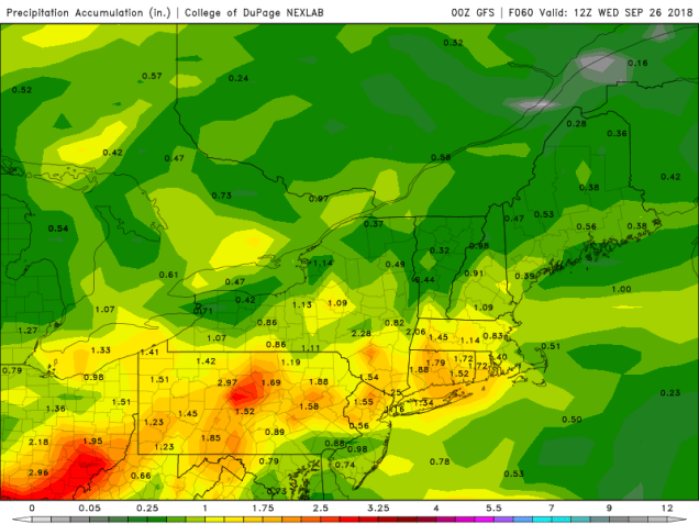
The cool air won’t hang around too long, as a warm front will move through late Tuesday. It will be preceded by some heavy rainfall. While this round of rain won’t compare to last week, when many places picked up 2-4 inches or more, we are still looking at 1-2 inches of rain for much of the region, which will lead to some nuisance flooding and ponding on roadways. The heaviest of the rain looks to fall from right around the morning commute until right around the evening commute. So, much of the day will be a washout.
Another round of heavy rain is expected on Tuesday. Image provided by the College of DuPage.
Wednesday will actually be another warm and humid day. with the warm front north of the region Temperatures should get well up into the 70s, with some lower 80s possible if we can get enough sunshine. However, you’ll need to keep the umbrellas handy once again. We may have some lingering showers in the morning, especially south of Boston, but it’s the afternoon that we need to keep an eye on. With a cold front approaching from the west, some thunderstorms will likely develop, and some of them could be strong to severe. The main threats with these storms will be heavy downpours and strong winds. While severe weather is uncommon in New England this late in the year, it is not unheard of. In fact, one of the strongest tornadoes ever recorded in New England, an F4, struck Windsor Locks, Connecticut on October 3, 1979.
Once the cold front moves through, high pressure builds in for the end of the week and into the weekend with dry and seasonably mild conditions. There are a few chances for a little rain, depending on which forecast model you happen to look at. So, this period might not be completely dry, but we’re certainly not looking at a washout either, at least not at this point.
Monday: Sunshine filtered through high clouds, but those clouds will start to thicken up late in the day. High 56-63.
Monday night: Cloudy. Low 47-54.
Tuesday: Breezy with periods of rain developing. possibly heavy at times. High 62-69.
Tuesday night: Rain tapers off to occasional showers, gradually ending overnight. Low 58-65 in the evening, then temperatures slowly rise overnight.
Wednesday: A few lingering showers south of Boston early, otherwise plenty of clouds with some sunny breaks. Breezy. Showers and thunderstorms develop in the afternoon, some of which may contain gusty winds and heavy downpours. High 73-80.
Thursday: Partly to mostly sunny. High 63-70.
Friday: Sunshine and a few clouds. High 64-71.
Saturday: Mostly sunny. High 65-72.
Sunday: Intervals of clouds and sunshine, slight chance for a shower. High 62-69.
Yup, It’s gonna rain alright. In fact, it’s gonna rain a LOT. But, overall, the week won’t be that bad.
The week actually starts off with high pressure hanging on for one more dry day. We may have some fog around in the morning, but once it burns off, we’ll see the sun come out. However, high clouds will start streaming in, dimming the sunshine. They’ll thicken up as the day goes on. Showers will develop at night what’s left of Florence starts to move toward the region.
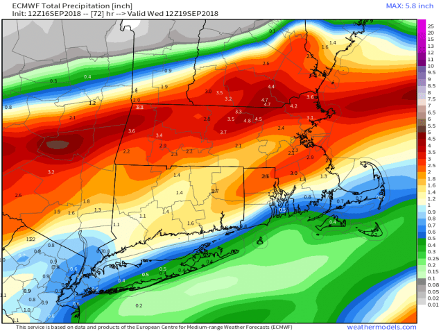
Exactly where the heaviest rain will fall is still a question, but a widespread heavy rainfall event is likely on Tuesday. Image provided by Weathermodels.com
The remains of Florence will move through on Tuesday, bringing us rain – a lot of it. Now, we’re not going to get 2-3 feet like they had in the Carolinas, but a widespread 1-3 inches is likely, with some heavier amounts. The rain will come down heavy at times, and winds will be a little gusty at times. We may even have a few rumbles of thunder. Some localized flooding is possible, so you may want to be careful if you’re out and about on Tuesday.
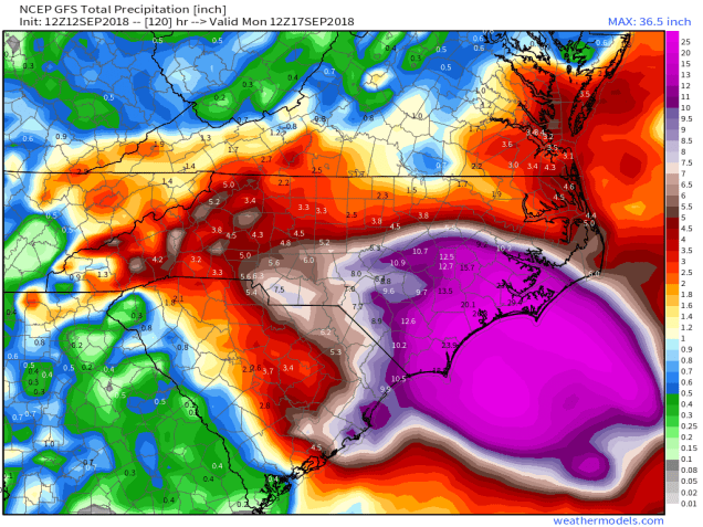
Rainfall totals across North Carolina from Florence through Sunday afternoon. To put this in perspective, Boston has received a total of 34.46″ of rain and melted snow since January 1. Swansboro, NC received 33.90″ of rain in the past 72 hours. Image provided by the National Weather Service Eastern Region Headquarters.
The rain ends Tuesday night, but skies may be slow to clear on Wednesday. Once they do high pressure builds in with drier and cooler conditions that last into Thursday. Another quick-moving system may bring in some more showers on Friday, before high pressure returns on Saturday. Then, another system quickly moves in for Sunday with more showers expected.
Monday: Morning fog burns off revealing sunshine which then fades behind increasing and thickening clouds. High 77-84.
Monday night: Cloudy with showers developing, becoming a steady rain by daybreak. Low 63-70.
Tuesday: Breezy with periods of rain, heavy at times, possibly a rumble of thunder. High 71-78.
Tuesday night: Showers ending in the evening, but skies remain mostly cloudy. Low 57-64.
Wednesday: Clouds eventually give way to partly to mostly sunny skies. High 66-73.
Thursday: A mix of sun and clouds. High 64-71.
Friday: Cloudy and breezy with some showers possible in the morning and then again late in the day and at night. High 72-79.
Saturday: Partly to mostly sunny. High 66-73.
Sunday: Cloudy with some rain possible. High 65-72.
Since our last blog post about the tropics yesterday, we’ve had some subtle, but important changes with most of the systems we’re watching.
As of early Wednesday afternoon, Hurricane Florence was centered about 485 miles southeast of Wilmington, North Carolina, moving toward the northwest at 15 mph. Maximum sustained winds are near 130 mph, making Florence a Category 3 Hurricane. Florence may strengthen a bit today as it moves over the warmer waters of the Gulf Stream while continuing on a northwestward track. Once it gets close to the coastline is where things start to get complicated.
GFS forecast for the track of Hurricane Florence. Loop provided by Tropical Tidbits.
The upper-level steering currents will collapse as the storm nears the coastline, which will cause the storm to slow down, and perhaps even stall out. Many of the models show this stall, followed by a slow drift toward the southwest. Exactly where it stalls is somewhat important. If the storm makes landfall, and then stalls out over southern North Carolina, it will quickly weaken, lessening the wind impact, but prolonging the heavy rainfall. If the storm stalls while the center is still offshore, it will weaken more slowly as it slowly churns up the warm water it is sitting over, but this will prolong the wind and storm surge impacts along the coast.
Tremendous amounts of rain are still expected in the Carolinas, leading to catastrophic flooding. Image provided by Weathermodels.com
These changes are actually a bit of good news for some areas, and bad news for others. This shift in track will significantly lessen the impact and amount of rainfall expected across the Mid-Atlantic states and even northern parts of North Carolina. While heavy rain is still expected, rainfall totals of 2-4 inches and locally heavier will not cause as much flooding as 6-12 inches of rain would. To the south, this is bad news – really bad news. The impact of rain, wind, and storm surge will be prolonged across southern North Carolina, and now will extend into a large portion of South Carolina. If the southwest trend in the track were to continue even longer, as a few models of shown, these impacts could even spread into parts of Georgia.
Model forecasts for the track of Tropical Storm Isaac. Image provided by Weathermodels.com
To the south, Tropical Storm Isaac is looking even weaker today, and the threat to parts of the Caribbean is diminishing. As of early Wednesday afternoon, Isaac was centered about 420 miles east of Martinique, moving toward the west at 17 mph. Maximum sustained winds have decreased to near 60 mph. Westerly shear has been impacting Isaac since Tuesday afternoon and is starting to rip the system apart. Since this shear is not expected to relax for another day or two. Tropical Storm Watches and Warnings are in effect for much of the Lesser Antilles. Isaac should cross the islands early on Thursday, bringing heavy rain and gusty winds to the region. However, the system should continue to weaken, and could degenerate into an open wave as it moves into the eastern Caribbean. It will still bring some heavy rain into Puerto Rico and the Virgin Islands, but won’t have anywhere near the impact of last year;s powerful storms. Some of the forecast models show the potential for the system to regenerate and strength as it moves into the western Caribbean this weekend, so even if the system does become an open wave in the next day or two, we’ll still keep an eye on its progress as it heads westward.
Model forecasts for the track of Hurricane Helene. Image provided by the University of Wisconsin.
As for Hurricane Helene, not much has changed. As of midday Wednesday, Helene was centered about 1350 miles south-southwest of the Azores, moving toward the north-northwest at 14 mph. Maximum sustained winds remain near 90 mph. Helene is expected to continue northward, steadily weakening while move over cooler waters. The current forecast calls for Helene to pass very close to or over the Azores this weekend as a tropical storm. Heavy rain and gusty winds would be the main threats to the Azores. The system should lose tropical characteristics over the weekend, but may impact parts of the British Isles as a strong extratropical system early next week.
A disturbance in the Gulf of Mexico could become a tropical depression in the next 24-36 hours. Loop provided by NOAA.
Meanwhile, an area of disturbed weather is slowly getting organized in the Gulf of Mexico. If this trend continues, the system could become a tropical depression tonight or Thursday. It should continue on a west to west-northwest track, heading towards Texas. The main threat with this system will be heavy rains across portions of southeastern Texas, likely leading to flooding in some areas.
Another disturbance is developing several hundred miles west of the Azores. Conditions are favorable for more development and this system could also become a tropical storm in the next day or so. This system will likely remain over open waters for the next several days, and is not a threat to any land areas right now.
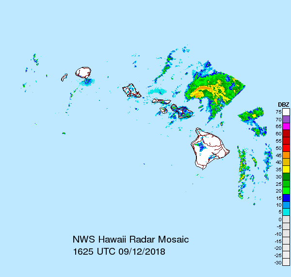
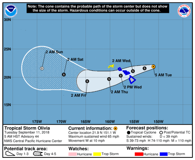
In the Pacific, Tropical Storm Olivia is gradually weakening while approaching the Hawaiian Islands. As of Wednesday morning, Olivia was centered about 140 miles east of Honolulu, moving toward the west at 12 mph. Maximum sustained winds have decreased to near 45 mph, and some additional weakening is expected. Tropical Storm Warnings remain in effect for Oahu and Maui County. Olivia will continue to bring heavy rain and gusty winds to the islands today. Rainfall totals of 5-10 inches and locally heavier will produce flooding in some areas. Once past the islands, Olivia should continue westward, likely dissipating over the open waters of the Central Pacific later this week.
Tropical Storm Barijat is passing south of Hong Kong. Loop provided by NOAA.
In the western Pacific, Tropical Storm Barijat remains fairly weak. As of midday Wednesday, Barijat was centered a little more than 100 miles south-southwest of Hong Kong, moving toward the west at 10 mph. Maximum sustained winds were near 45 mph, and Barijat is expected to slowly weaken while continuing westward, likely making landfall in southern China over the next 12-18 hours. Heavy rain may lead to flooding across portions of southern China and northern Vietnam before the system dissipates.
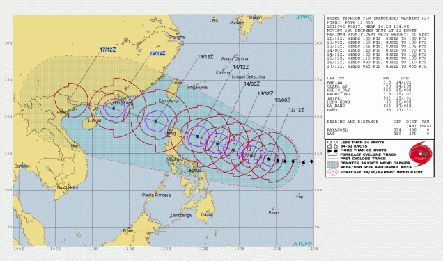
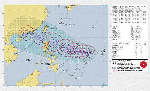
Super Typhoon Mangkhut will become an increasing threat to the Philippines later this week. Image provided by the Joint Typhoon Warning Center.
Meanwhile Super Typhoon Mangkhut remains a beast of a storm this afternoon. As of midday Wednesday, Mangkhut was centered about 870 miles east of Manila, moving toward the west at 14 mph. Maximum sustained winds are near 170 mph, making Mangkhut the strongest storm on the planet so far this year. Mangkhut has likely peaked in intensity, and a slow weakening trend is expected over the next few days. As for Mangkhut’s future, the forecast track has shifted a bit to the south since yesterday. This will now bring the center of the storm close to or over northern portions of Luzon, the largest of the islands in the Philippines. The northern tip of the island is somewhat rural, with hilly terrain, which means the storm wouldn’t affect as many people, but it will still be at or close to Super Typhoon intensity at the time, so a major impact is still expected. After that, a track into the South China Sea is still expected, with some additional weakening likely before a final landfall late this weekend early next week in the same vicinity of where Barijat is expected to make landfall today or tomorrow.
There are currently 7 active tropical systems in the Atlantic and Pacific Ocean, and amazingly, 6 of them could be threats to land within the next 5 days.
The storm that is rightfully gaining the most attention (and hype) is Hurricane Florence. As of early Tuesday afternoon, Florence was centered about 370 miles south-southwest of Bermuda, moving toward the west-northwest at 17 mph. Florence reached Category 4 strength Monday evening, before undergoing and eyewall replacement cycle. What that means is that the intense thunderstorms surrounding the eye of the storm essentially weaken, but a new ring of storms forms farther away from the center. These eventually contract to form a new eyewall. While this will weaken a storm a bit, it also expands the radius of the wind field. Now that Florence has undergone this process (which will likely happen again at some point in the next day or two), its maximum sustained winds have decreased to around 130 mph, making it a Category 3 hurricane. A Hurricane Watch and Storm Surge Watch have been issued for most of the coastline of North Carolina and South Carolina.
This probably isn’t a good time for a trip to the Outer Banks. Image provided by WeatherBell.
Florence is expected to continue in a general west-northwest direction for the next day or two, with some additional strengthening expected. It should regain Category 4 status later today, and there is a chance it could reach Category 5, depending on when the next eyewall replacement cycle takes place. By Thursday, high pressure will build in north of Florence, which will start to slow the system down as it approaches the North Carolina coastline.
That’s a lot of rain, and the scary part is, this might be an underestimate. There’s going to be a LOT of flooding, even well inland. Image provided by Weathermodels.com
Most of the forecast models show the system slowing to a crawl or even stalling out by Friday. The big question is, does it stall out before landfall or after landfall? No matter where it stalls, many of the effects will be the same, it will just determine what happens down the road. The strongest winds will be confined to areas closest to the coastline. Once the storm stalls out, especially if it is over land, it will start to weaken, with winds becoming less of a problem, especially the farther away from the center you area. Storm surge will also be a major problem, especially across the Outer Banks and Pamlico and Albemarle Sounds, but again, once the storm is weakening (and likely inland), the storm surge threat starts to decrease. By far, rainfall and resultant flooding is the largest threat. Tropical systems already produce copious rainfall, but when they stall out, the amounts become that much higher – just look at what Hurricane Harvey did to Texas last year. In this case, with the storm expected to sit near or over the Carolinas for a few days, we could be looking at rainfall totals of 15-30 inches or more, which could lead to some of the worst flooding the region has ever seen. The torrential rain will also spread into neighboring parts of Virginia as well. Beyond that, we’ll have to see where the storm actually goes before we can tell if the heavy rain will spread to other areas.
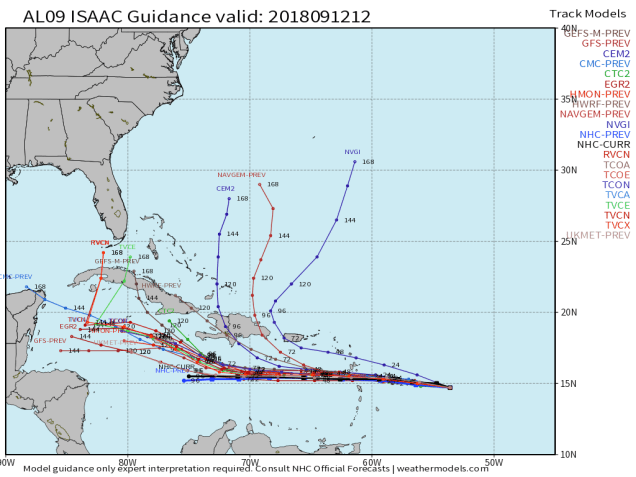
To the south, Tropical Storm Isaac is a threat to portions of the Lesser Antilles, but how much of a threat is a question mark. After briefly reaching hurricane status, Isaac weakened to a tropical storm on Monday. As of early Tuesday afternoon, Isaac remained a tropical storm with maximum sustained winds near 70 mph. It was centered about 725 miles east of the Lesser Antilles, moving towards the west at 16 mph. This track is expected to continue for the next few days, and as a result, Hurricane Watches and Tropical Storm Watches have been issued for some of the islands. Isaac is encountering some westerly shear that produced the weakening on Monday, and this will likely continue, preventing the system from strengthening much, and could result in some additional weakening. The official forecast calls for Isaac to be near hurricane strengthen when it approaches the Lesser Antilles, but we wouldn’t be surprised if it was significantly weaker. Either way, Isaac will bring gusty winds and heavy rain to many of the islands as it moves through on Thursday. It should remain south of Puerto Rico and the Virgin Islands, which are still recovering from last year’s double whammy of Irma and Maria. Some locally heavy rainfall is possible across these islands from Isaac’s outer bands as it passes to the south, but a direct hit is not expected. Beyond that, Isaac may weaken further as it continues across the Caribbean Sea.
Isaac is heading toward the Caribbean. Image provided by the National Hurricane Center.
To the east, Hurricane Helene is starting to weaken over cooler waters in the Eastern Atlantic. As of midday Tuesday, Helene was centered about 1550 miles south-southwest of the Azores, moving toward the northwest at 12 mph. Helene’s maximum sustained winds were near 110 mph, but gradual weakening is expected over the next few days as the storm heads more toward the north. As we get toward the weekend, Helene should weaken to a tropical storm and may start to lose is tropical characteristics as it approaches the Azores. Gusty winds and heavy rain would be the main threats to the islands. Beyond that, it could impact parts of the British Isles as an extratropical system early next week.
Helene is a fish storm for now, but it could impact the Azores…..and Ireland? Image provided by the University of Wisconsin.
Another disturbance is moving across the northwestern Caribbean and into the Yucatan Peninsula this afternoon. This system remains disorganized for now, but as it moves into the Gulf of Mexico over the next day or two, conditions could become favorable for some development. Whether it develops or not, it will bring heavy rainfall to parts of the Yucatan today and the Gulf Coast, especially Texas, over the next several days. There’s also another weak area in the North Atlantic being watched well southeast of Newfoundland. However, it’s not tropical now, it might not ever be tropical, and it’s not going to amount to much more than a fish storm if it even becomes tropical or subtropical, so we’re not even going to bother to say any more about it.
Olivia looks like it’s going to go right across the Hawaiian Islands. Surf’s up, but so are the Tropical Storm Warnings, and in another day or two, the water levels as well. Image provided by the Central Pacific Hurricane Center.
In the Eastern Pacific Tropical Depression Paul is nearly 1000 miles southwest of Mexico, and expected to dissipate over open water in the next 24-36 hours, so we really don’t need to spend any more time on that storm. To the west, Tropical Storm Olivia is bearing down on the Hawaiian Islands. As of early Tuesday afternoon, Olivia was centered about 380 miles east of Honolulu, moving toward the west at 10 mph. Maximum sustained winds were near 65 mph, and slow by steady weakening is expected over the next few days. Tropical Storm Warnings are in effect for most of Hawaii, except Kauai where a Tropical Storm Watch is in effect. Olivia is expected to cross the Hawaiian islands on Wednesday. Unlike Hurricane Lane a few weeks ago which produced heavy rain across the Big Island, but stayed offshore, Olivia will likely bring heavy rain and gusty winds to much of the island chain. In some of the mountain areas, especially on the Big Island, rainfall totals of 10-20 inches and locally heavy may result in flooding in some areas once again.
Most tropical systems that impact Hawaii don’t come in from the east, especially not ones moving across the central part of the island chain. Image provided by the Central Pacific Hurricane Center.
In the Western Pacific, Tropical Storm Barijat is expected to move across the South China Sea over the next few days while remaining fairly weak. As of midday Tuesday, Barijat was centered about 215 miles southeast of Hong Kong with maximum sustained winds near 40 mph, moving towards the west at 12 mph. It should continue on a general westward track for the next day or so with some strengthening possible, before crossing China’s Leizhou Peninsula late Wednesday. After that, it is expected to weaken before making a final landfall as a weak tropical storm or a tropical depression in northern Vietnam on Thursday or Friday. Heavy rain is the main threat with this system.
Tropical Storm Barijat remains weak southeast of Hong Kong, but does have a nice cluster of strong thunderstorms near the center. Loop provided by NOAA.
The bigger story in the Western Pacific is Super Typhoon Mangkhut. At midday Tuesday, Mangkhut, located roughly halfway between the Northern Mariana Islands and northern Philippines, had maximum sustained winds near 160 mph. It is moving westward at 14 mph, but a turn more toward the west-northwest is expected over the next day or two. Mangkhut has likely not peaked in intensity yet, and could strengthen a bit more over the next 24-36 hours. Yesterday, it crosses the Northern Mariana Islands, producing wind gusts of up to 90 mph and dropping over 10 inches of rain on Guam.
Mangkhut is a Super Typhoon, and should remain one for another 2-3 days. After that, how strong it is will be determined by how close it comes to northern Luzon. Image provided by the Joint Typhoon Warning Center.
The current forecast calls for Mangkhut to pass just north of the Philippines later this week, likely close enough to bring heavy rain and strong winds to Luzon. A deviation slightly to the south of the expected track could result in landfall, and significant impacts to northern Luzon. Beyond that, a track into the South China Sea and some slow weakening is expected. The storm will become an increasing threat to southern China, including Hong Kong, by this weekend.
We’ve got a little bit of everything in the forecast this week – cool weather, warm and humid weather, heavy rain, thunderstorms, and sunshine. What about a hurricane? Not likely in this neck of the woods, but we’ll get to Florence in this outlook.
While we’re looking at a cool start to the day, up north, skies are clear and low temperatures will dip into the 20s and 30s this morning in parts of Northern Maine. That’ll be coming here soon enough. Image provided by WeatherBell.
The week starts off on a cool note with high pressure trying to hang on, but it will lose its grip on the region quickly. A warm front will start to move up from the south while low pressure also starts to approach from the west. That low pressure area contains the remains of Tropical Storm Gordon, and thus is very juicy. It dropped several inches of rain on the Ohio valley and Mid-Atlantic states over the weekend. Rain should spread across our area today from south to north. Some of the rain could be locally heavy, especially today and tonight. We’ll also have some gusty winds, especially along the coastline. These winds, combined with astronomical high tides, could result in a little bit of coastal flooding, especially along east-facing shorelines around high tide. Keep that in mind if your travels bring you along the coast around midday today. Rough surf from Florence will start impacting the coast, especially the south coast over the next day or two, and will likely build through the week.
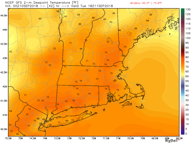
The rain continues tonight as a warm front moves across the area. Temperatures will actually go up overnight as the warm and humid air moves in. Tuesday will not be a washout, but we’ll have occasional showers and thunderstorms with the warm and humid air in place. Low pressure passes north of the region later Tuesday, bringing a cold front in. The front will likely dissipate as it tries to cross the area, but will provide just enough instability for more showers and thunderstorms on Wednesday.
Dewpoints will jump back into the 70s across the area on Tuesday. Image provided by WeatherBell.
High pressure builds in on Thursday, with sunshine and less humid conditions expected. This high will remain in place right through the weekend, with partly to mostly sunny skies, warm conditions and comfortable humidity. It will also serve to block Hurricane Florence from coming up here. It could also make things that much worse for the Mid-Atlantic states and the Southeast.
The Atlantic remains quite active with Florence, Isaac, Helene and a potential system in the western Caribbean. Loop provided by NOAA.
The exact track of Florence is still a question, that it seems fairly certain that it will at least come close to the Carolinas. Whether or not it makes landfall is still not certain. One thing that does seem more likely is that Florence is going to stall out somewhere near the Carolinas as it gets blocked by the high sitting over the Northeast. Whether it stalls just off the coast or inland will make a difference in terms of how much wind and storm surge damage and how quickly the system starts to wind down. What it won’t make a difference with is the fact that it’s going to produce a lot of rain across the area, with widespread flooding. Determining exactly what area will get what conditions will be something that we’ll narrow down in the next few days as we get a better of idea what the track that Florence will take.
The ECMWF is forecasting as much as 15-30 inches of rain, centered in inland North Carolina southwestern Virginia. Image provided by Weathermodels.com
The GFS is forecasting as much as 15-30 inches of rain, centered in coastal North Carolina southeastern Virginia. Image provided by Weathermodels.com
Monday: Cloudy, breezy, and cool with showers developing from south to north, becoming a steady rain late in the day. High 60-67.
Monday night: Periods of rain, heavy at times in the evening, tapering off to showers overnight, maybe a rumble of thunder or two as well. Temperatures slowly rise overnight.
Tuesday: Plenty of clouds, breezy, humid, occasional showers and thunderstorms. High 76-83.
Tuesday night: Mostly cloudy with a few showers and some patchy fog possible. Low 63-70.
Wednesday: More clouds than sunshine chance for a few showers or thunderstorms. High 76-83.
Thursday: Becoming partly to mostly sunny. High 74-81.
Friday: Plenty of sunshine. High 73-80.
Saturday: Sunshine continues. High 75-82.
Sunday: Sunshine and some high clouds. High 76-83.
We wrote an extensive post about the tropics Saturday night, and not much has changed since then. Hurricane Helene is pulling away from the Cabo Verde Islands and destined to be a fish storm. Hurricane Isaac will become an increasing threat to the Lesser Antilles in the next few days. Hurricane Olivia will weaken before crossing the Hawaiian Islands tomorrow. Tropical Storm Warnings are in effect for much of the island chain. Tropical Storm Paul will remain weak over open water in the Eastern Pacific. Typhoon Mangkhut is crossing the Northern Mariana Islands this morning. A new tropical depression has also formed near Taiwan. We may also have another system to watch in the Gulf of Mexico later this week. We’ll have another special blog post about the tropics tomorrow, where we’ll go into a little more detail, especially about Florence, Isaac, Olivia, and the potential system in the Gulf, since those are the ones that will be the biggest threats to land.
It seems like just a week or two ago we were saying how quiet that the Atlantic had been. Now, Mr. Dolby is right, it’s hyperactive – and so is the Pacific.
Right now, all of the media hype is centered on Tropical Storm Florence. As of 5pm EDT Saturday, Florence was centered about 800 miles southeast of Bermuda, moving toward the west at 5 mph. After reaching Category 4 strength a few days ago, Florence has weakened to a tropical storm with maximum sustained winds near 70 mph. Over the next day or two, Florence will be moving into an area where conditions will be favorable for development, plus there is plenty of warm water ahead, so the system will likely become a hurricane again. Rapid strengthening is possible over the next few days, and Florence could become a Major Hurricane (Category 3 or stronger) again over the next few days.
There is plenty of warm water in the western Atlantic to help fuel a strong hurricane. Image provided by Weathermodels.com
The future track of Florence still has plenty of questions that can’t be answered yet, but have significant implications. A ridge of high pressure will build in to the north of Florence, sending it on a general westward track, towards the southeastern United States for the next couple of days. The questions are – How strong is that ridge to the north of Florence? How will it be oriented? If it’s strong enough, it will continue to drive the system west or west-northwestward, sending it into the Carolinas, Georgia, or possibly even northern Florida. If the high is weaker, or centered a little more to the east, it could allow the system to turn more northward as it gets close to the coastline, which could allow it to recurve out to sea without making landfall, or it could stall close to the coastline. This will obviously determine what impacts Florence may or may not have on the Southeast (as well as the Mid-Atlantic and possibly even the Northeast) later in the week. People with interests along the East Coast, especially the Mid-Atlantic states and the Southeast, should keep a close eye on the future of Florence. Rough surf ahead of Florence will impact most of the East Coast beginning on Sunday, and continuing through the week.
Forecast tracks for Florence based on the 20 members of the GFS Ensemble. Image provided by the University at Albany.
Forecast tracks for Florence based on the 51 members of the ECMWF Ensemble. Image provided by the University at Albany.
While Florence is gathering all of the attention (and the hype), it is far from the only system that is a threat to land right now. Newly-formed Tropical Storm Isaac was centered about 1640 miles east of the Windward Islands as of 5pm EDT Saturday, moving toward the west at 7 mph. Isaac had maximum sustained winds near 40 mph, and is expected to steadily strengthen over the next few days while crossing the Atlantic. The current forecast calls for Isaac to become a hurricane by early in the week. As we get toward midweek, if it continues on its current westward track, it could become an increasing threat to the Lesser Antilles. Many parts of this area are still recovering from getting battered by Irma and Maria last summer, and were hoping for a quiet hurricane season. This is not the news that anybody in that region wants to hear.
A hurricane heading for the Caribbean? No, that’s not what anybody wants to hear, not after last season. Image provided by the University of Wisconsin.
To the east, Tropical Storm Helene is a threat to the Cabo Verde Islands tonight and Sunday. Tropical Storm Warnings and Hurricane Watches are in effect for the islands of Santiago, Fogo, and Brava. As of 8pm EDT Saturday, Helene was centered about 125 miles southeast of Praia in the Cabo Verde Islands, moving towards the west at 13 mph. Maximum sustained winds are near 60 mph, and additional strengthening is expected. Helene could become a hurricane on Sunday. It will bring gusty winds and heavy rainfall to parts of the Cabo Verde Islands for the next 24-36 hours. Rainfall totals of 4-8 inches could result in flooding and mudslides across the islands. Once it pulls away from the islands later on Sunday, it should continue off toward the west-northwest while strengthening a bit more. By mid-week, a turn more towards the northwest is expected, with a weakening trend ensuing as Helene moves over colder waters.
Forecast track for Tropical Storm Helene. Image provided by the National Hurricane Center.
Think all the action is in the Atlantic? Think again – the Pacific remains active as well. Hurricane Olivia was centered about 1000 miles east of Hilo, Hawaii Saturday evening, moving towards the west at 15 mph. We know that we were more focused on Norman earlier in the week, but Norman is out of the picture, and Olivia is now the bigger threat. Olivia has maximum sustained winds near 85 mph right now. The forecast for Olivia is for a general west to west-southwest motion over the next few days, with a gradual weakening trend expected. By mid-week, Olivia should have weakened to a tropical storm as it approaches and then moves across the Hawaiian Islands. Rough surf is expected across Hawaii over the next few days, with gusty winds likely as the system approaches later on Tuesday and into Wednesday. The main threat with this system will be heavy rain, leading to flooding across the area. Hurricane Lane brought torrential rainfall and flooding to the area a few weeks ago, and this will likely renew flooding in some of the same areas that have not cleaned up yet. We’re not expecting 20-40 or more inches of rain like Lane produced, but 8 to 15 inches and locally heavier is possible, especially in the normally favored upslope locations.
Just what Hawaii needs – more rain! Model forecasts for the track of Hurricane Olivia. Image provided by Tropical Tidbits.
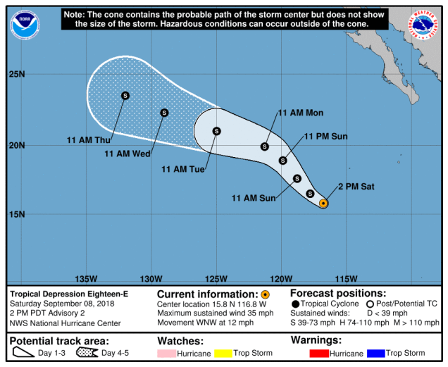
Back to the east a bit, Tropical Depression 18-E has formed off the west coast of Mexico. As of Saturday evening, the system was centered about 665 miles southwest of Cabo San Lucas, Mexico, moving toward the west-northwest at 12 mph. Maximum sustained winds are near 35 mph, and strengthening is expected. The system should become a tropical storm on Sunday. The storm should head northwestward for the next 24-36 hours, before turning back towards the west-northwest. It should remain over open water, with no threat to any land areas. At this time, the system is not expected to become a hurricane before it starts to weaken over colder waters towards midweek.
Forecast track for Tropical Depression 18-E. Finally, a fish storm that is no threat to land. Image provided by the National Hurricane Center.
We’re not done yet! Heading much farther to the west, Tropical Storm Mangkhut (not King Tut) continues to strengthen in the Western Pacific Ocean. As of Saturday evening, Mangkhut was centered a little more than 800 miles east of Guam, moving toward the west at 23 mph. It has maximum sustained winds near 65 mph, and is expected to steadily strengthen while heading westward over the next few days. It should become a typhoon on Sunday. The system is expected to move across the Northern Mariana Islands on Monday as a strengthening typhoon. Strong winds, torrential rainfall and storm surge are all threats to the islands, including the large US military presence on Guam. Considering that it’s a small island in the middle of the vast Pacific Ocean, Guam actually gets hit by typhoons quite a bit. Mangkhut should continue on a general west or west-northwest course beyond that, possibly becoming a Super Typhoon (equivalent to a Category 4 or 5 Hurricane in the Atlantic/Eastern Pacific) by midweek. Its too early to determine where it goes beyond that, but it could become a threat to the northern Philippines, Taiwan, or southeastern China late in the week.
Forecast track for Tropical Storm Mangkhut. Image provided by the Joint Typhoon Warning Center.
Believe it or not, that’s not all. It looks like another tropical system could be developing closer to the northern Philippines. We’ll worry about that one once it actually forms. we’ve got our hands full already.
By the way, we didn’t even get to what’s left of Tropical Storm Gordon. Yeah, we’re focusing on active tropical systems in this post, but Gordon is going to bring heavy rain to the Ohio Valley into Sunday, and parts of the Mid-Atlantic and Northeast later Sunday into Monday. Several inches of rain are possible in parts of this area, with flooding expected. We’ve lost count of how many times this has happened in the Mid-Atlantic states this year. Somehow, we have a hunch that this isn’t the last time it’ll happen this year either.
The peak of hurricane season in the Atlantic occurs around September 10 on average. As we rapidly approach that date, the Atlantic is heating up. We’ve got two named storms right now, and possibly another on the way. Things aren’t quiet in the Pacific either.
The Atlantic is getting active again. We’ve got Gordon in the Gulf, and Florence for the fishes. Loop provided by NOAA.
The biggest threat right now is Tropical Storm Gordon. As of midday Tuesday, Gordon was centered about 130 miles south-southeast of Mobile, Alabama, moving towards the northwest at 15 mph. Maximum sustained winds were near 65 mph, and some additional strengthening is possible. Gordon doesn’t look like a classic tropical system just yet, but there are signs that it is getting its act together, and it could become a hurricane before making landfall along the Mississippi or Alabama coastline tonight. Hurricane and Tropical Storm Warnings are in effect for much of the north-central Gulf Coast, with a Storm Surge Warning also in effect for parts of the area.
There’s a lot of rain heading for the Gulf Coast and the Deep South over the next few days. Image provided by Weathermodels.com
While storm surge flooding and strong winds are threats with Gordon, heavy rain will be a more prolonged threat to the region. Once it makes landfall it will slow down, which is not good news at all. This will keep the heavy rain threat going for a few days. Rainfall totals of 3-6 inches, with localized totals to 10 inches or more, could result in flooding across much of the region. By Friday, as the system continues to drift northward, an approaching cold front will pick it up, and send it off towards the Ohio Valley and Great Lakes.
Meanwhile, in the Central Atlantic Ocean, Florence has become the third hurricane of the season. As of midday Tuesday, Florence was about halfway between the Lesser Antilles and Cape Verde Islands, moving toward the west-northwest at 12 mph. Florence has maximum sustained winds near 75 mph, but the current forecast calls for Florence to weaken a bit over the next few days before regaining a little strength. Florence should continue in a general northwestward track through the week, remaining over open water. After that, things may get a little complicated.
Florence will head towards the northwest for the next few days. After that? That’s a really good question. Image provided by WeatherBell.
The steering currents in the central Atlantic Ocean are forecast to weaken later this week, making the future track of Florence a lot more uncertain once we get into the weekend. Right now, the more likely scenario is the usual one – an approaching trough of low pressure picks up Florence and it curves northward and eventually harmlessly out to sea. However, if that trough is not strong enough to grab Florence, it could meander around for a while or start to drift westward as a ridge of high pressure builds back in to the north. While Florence would still likely head out to sea eventually, this scenario would imply a potential threat to the East Coast later next week. We won’t know which scenario is more likely until we get to this weekend at the earliest. There are a few models, as well as members of some of the Ensembles that do show that threat. As we mentioned in our Weekly Outlook, we think that the odds of an East Coast impact are fairly low at this point (despite the internet hype), but they are certainly not zero, so we’ll keep an eye on it.
But wait, there’s more! A developing low pressure system is passing south of the Cape Verde Islands today. It is expected to continue on a general west to west-northwest track over open waters for the next several days. Conditions are favorable for development, and the system could become a tropical depression later this week. It is still a week away from impacting any land areas, if it were to even get that far.
We may have yet another Atlantic system to deal with later this week. Image provided by Tropical Tidbits.
In the Pacific, Hurricane Olivia will strengthen a bit more over the next day or two as it continues to move away from Mexico and into the open waters of the Eastern Pacific, so we won’t spend much time on it. Hurricane Norman, however, is the system getting attention in that part of the world.
Hawaii isn’t going to get hit again (at least not yet). Norman should turn well before getting near the Islands. Image provided by the Central Pacific Hurricane Center.
As of Tuesday morning, Norman was centered about 750 miles east of Hilo, Hawaii, moving toward the west at 17 mph. Maximum sustained winds were near 85 mph. Norman is expected to maintain its current strength for another day or two before a weakening trend begins. The system is expected to turn more toward the northwest later this week, passing safely east and north of Hawaii towards the end of the week. It will send some rough surf towards the islands, but that should be the only impact as the region continues to recover from Hurricane Lane.
What about the Western Pacific? Anyone care? Anyone? Bueller? Typhoon Jebi made landfall on Japan’s main island of Honshu early this morning. It’s weakened to a tropical storm, and has moved into the Sea of Japan. It should weaken and dissipate as it moves into far eastern Russia over the next day or so.
We’re into September, which means that meteorological fall has started. Time for cooler weather, leaves changing colors, pumpkin-flavored everything, and football. So naturally, we’re starting the week off with hot and humid conditions.
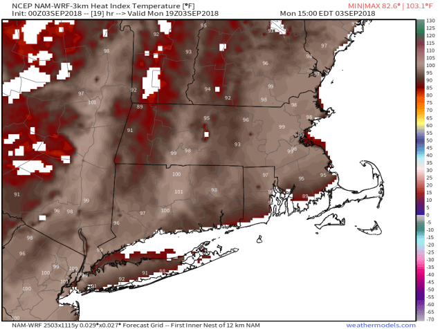
A ridge of high pressure remains in place off the East Coast, so the hot and humid weather that we’ve dealt with for much of the summer has returned. Heat Advisories are in effect for much of the region, as temperatures should get well into the 80s and lower 90s both today and Tuesday. However, with dewpoints in the upper 60s and 70s, the heat index will be in the middle to upper 90s, hence the heat advisories.
Heat indices will be well into the 90s across the region this afternoon. Image provided by Weathermodels.com
Later on Tuesday, a backdoor cold front will drop southward, bringing some cooler air into eastern parts of the area for Tuesday night and Wednesday. “Cooler” is a relative term. In April or May, a backdoor front results in easterly or northeasterly winds off of water that is only in the 40s and 50s, so coastal areas get quite chill while it stays relatively mild well inland. In this case, we’ll have northeast or east winds blowing off of water that is in the lower 70s, so it’s not going to cool off that much at the coast.
The front lifts back northward Wednesday night, resulting in another hot and humid day on Thursday. However, a cold front will be approaching from the northwest. This front may kick off some showers and thunderstorms late in the day and into Thursday night and early Friday. This is where things get more questionable. That front will likely stall out near the South Coast. Exactly where it stalls out is not clear though. If it stalls right along the South Coast, then Friday and Saturday could be cool and damp with periods of showers at times. If it stalls much farther offshore, then the clouds may hang around, especially from Boston southward, but the showers would likely stay offshore. For now, we’re leaning towards the drier scenario. Sunday is an even bigger question mark. One model has high pressure build in with partial sunshine and temperatures only in the 60s, while another model has low pressure move into the Great Lakes, likely the remains of what is currently Potential Tropical Cyclone Seven (more on that in a moment), with cool conditions, but also some rain in the afternoon. Since that’s the Patriots home opener, we’ll be keeping an eye on that forecast as the week goes on.
Here’s hoping that Sunday looks more like this than damp at Gillette Stadium. Image provided by ESPN.
Labor Day: Some patchy fog early, otherwise partly to mostly sunny. High 86-93, a little cooler along the South Coast.
Monday night: Clear to partly cloudy. Low 68-75.
Tuesday: A mix of sun and clouds, chance for a few showers. High 85-92, turning cooler along the east coast in the afternoon.
Tuesday night: Partly to mostly cloudy. Low 64-71.
Wednesday: Early clouds, then becoming partly to mostly sunny. High 81-88, coolest along the coast.
Thursday: Sunshine fades behind increasing clouds, showers and thunderstorms are possible late in the day and at night. High 87-94.
Friday: Mostly cloudy, a few more showers are possible. High 72-79.
Saturday: Intervals of clouds and sunshine. High 68-75.
Sunday: More clouds than sun, chance for showers in the afternoon. High 65-72.
Satellite loop showing a tropical disturbance near the Bahamas and South Florida and Tropical Storm Florence in the Central Atlantic Ocean. Loop provided by NOAA.
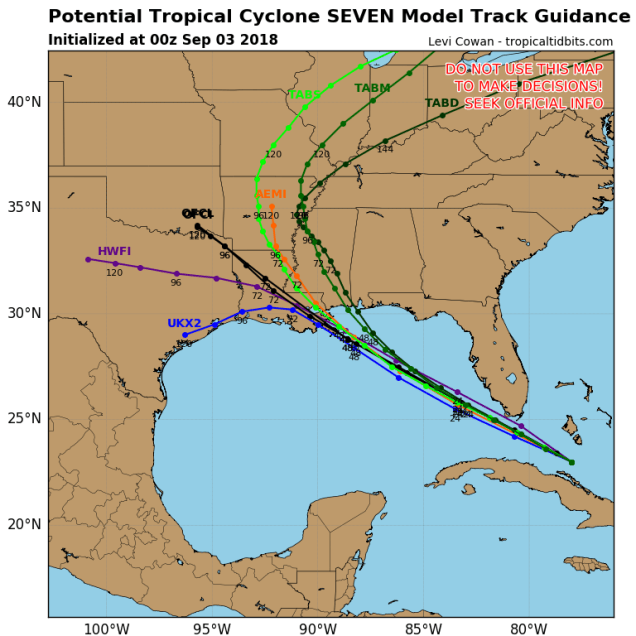
Now that we’re into September, we’re approaching the peak on tropical season in the Atlantic, and we have 2 systems to keep an eye on. The more immediate threat is a system that at the time this blog was written was still labelled Potential Tropical Cyclone Seven”. It is expected to become a tropical depression at some point on Monday as it crosses the Florida Keys. It will then turn northwestward while strengthening over the Gulf of Mexico. The current track calls for landfall in southeastern Louisiana Tuesday night as a tropical storm. Storm surge flooding and gusty winds will be threats with this system, but the main threat is heavy rain that could lead to flooding across much of the Gulf Coast.
A tropical system in the Gulf always needs to be monitored. This one is no exception. Image provided by Tropical Tidbits.
Well out into the Atlantic we have Tropical Storm Florence. Florence is expected to remain fairly weak as it crosses the Atlantic over the next several days, with only some minor fluctuations in intensity. You may have read on the internet over the weekend that Florence is a threat to the East Coast. Yes, a couple of the models do show that potential, but many others don’t. At this point, it’s more hype than anything else. If it were to become a threat, that would still be a good 10 days or so from now. We’re not worried about it right now. We’d put the odds of an East Coast threat fairly low right now, but not zero, not yet. If it were to become a threat, we’d let you know well in advance.


")
")