Weekend Outlook: August 21-24, 2026

Some rain is on the way for parts of the weekend, but it won’t be a washout.
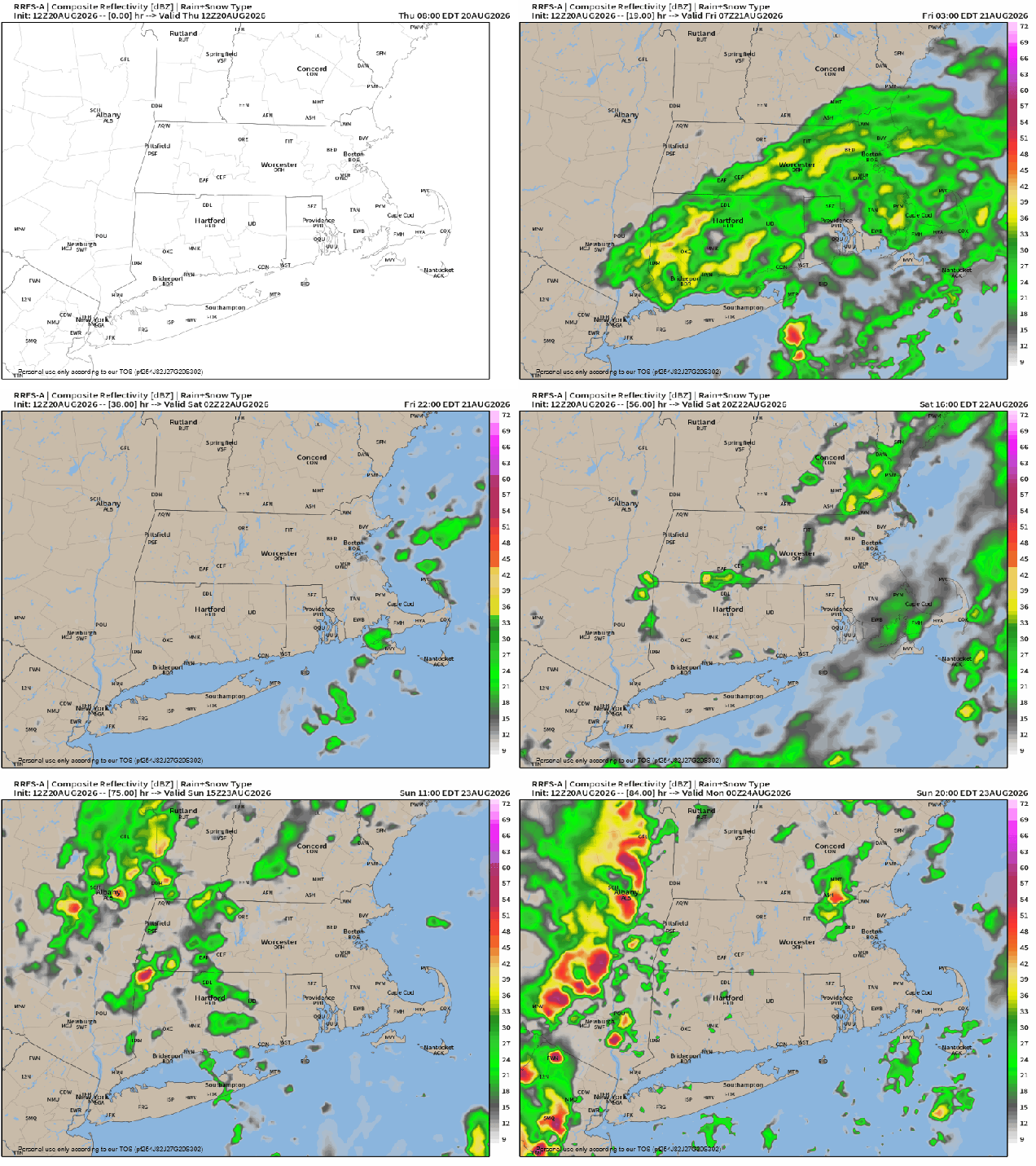
Episodes of showers and dry periods are likely through the weekend. Loop provided by weathermodels.com

A cold front will move across the region this evening and then stall out just to the south, controlling our weather for the next few days. Showers shower taper off this evening as the front settles south, but may continue across parts of the South Coast and Cape Cod into the night. High pressure will try to build in from the north on Friday with some drier air, but a wave of low pressure riding along the front to our south may bring in another period of showers to parts of Rhode Island and southeastern Massachusetts. As we get into the weekend, an upper-level low pressure area will settle into southeastern Canada. Disturbances rotating around it may help trigger additional waves of low pressure riding along the front. Another batch of showers will likely accompany one of those waves late Saturday and Saturday night. Sunday looks to be a day with some sun and occasional showers. Keep an eye to the sky (or radar) if you have outdoor plans. Much of the day should remain dry, but there will be some showers around. By Monday, high pressure starts building back in, but with the upper low nearby we’ll still have some clouds and maybe a shower or two.

Some heavier rainfall totals are possible south of Boston this weekend. Images provided by Pivotal Weather.

Thursday night: Plenty of clouds, some showers during the evening, possibly lingering into the overnight near the South Coast and Cape Cod. Low 59-66.

Friday: Some sunshine from the Merrimack Valley into southern New Hampshire, lots of clouds elsewhere, chance for a few showers across southeastern Massachusetts and Cape Cod. High 71-78.

Friday night: Mostly cloudy, chance for a shower or two across Cape Cod. Low 58-65.

Saturday: Plenty of clouds, showers likely, especially during the afternoon, mainly south of Boston. High 69-76.

Saturday night: Cloudy with more showers. Low 60-67.

Sunday: Clouds and some sunny breaks, some occasional showers possible. High 74-81.

Sunday night: Showers taper off in the evening, becoming partly cloudy. Low 60-67.

Monday: A mix of sun and clouds, chance for an afternoon shower. High 76-83.
Weekend Outlook: January 9-12, 2026

A pair of storm systems will impact our weather over the next few days, but mostly with rain, not snow.

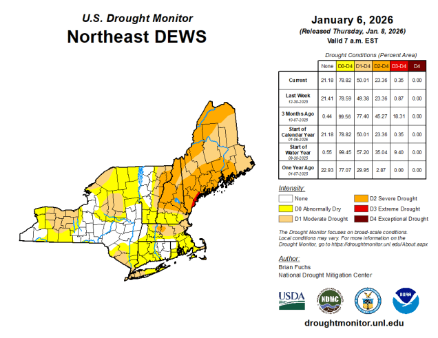
It’s been fairly dry so far this winter, so we’re still experiencing drought conditions across much of the region. Image provided by the National Drought Mitigation Center.

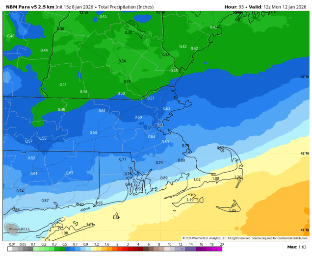
High pressure will slide off to the east tonight, with winds shifting into the southwest, bringing some milder air in. Friday will be relatively mild (by January standards), but clouds will be streaming in ahead of a low pressure system headed for the Great Lakes. As that system moves into Quebec some showers are likely ahead of it Friday evening before a cold front moves through overnight. That front will stall out south of New England allowing some cooler air to move back in. Meanwhile, another low pressure system will head towards the Great Lakes, trying to bring that front back northward as a warm front. As that system moves into Ontario, a secondary low pressure system will develop off the Mid-Atlantic coastline., preventing that warm front from moving in, and giving the new low pressure area a path eastward. This will bring more substantial and widespread rain in for late Saturday into Sunday morning. However, with the cold air in place, precipitation may start as some sleet or freezing rain well north and west of Boston, mainly interior southern New Hampshire and northern Worcester County, as the rain moves in later Saturday. A few additional rain or snow showers in the afternoon as an upper-level low pressure area crosses the Northeast, then high pressure builds in for Monday with cooler and drier conditions. For the Patriots game Sunday evening, it should be mostly cloudy at kickoff, winds out of the northwest at 5-10 mph, with a game time temperature around 37, dropping into the lower 30s by the end of the game.

Much of the area could receive between half an inch and one inch of rainfall this weekend. Image provided by WeatherBell.

Thursday night: Becoming partly to mostly cloudy. Low 22-29.

Friday: More clouds than sun, becoming breezy in the afternoon, showers possible towards evening. High 41-48.

Friday night: Cloudy with showers likely, mainly before midnight. Temperatures continue to rise until midnight, then drop to 33-40 by daybreak.

Saturday: Mostly cloudy with rain developing from southwest to northeast, possibly starting as some sleet or freezing rain well north and west of Boston. High 40-47.

Saturday night: Any mixed precipitation changes to all well rain north and west of Boston, periods of rain elsewhere. Low 33-40.

Sunday: Rain ends by midday, mostly cloudy with a few more rain or snow showers possible late in the day. High 38-45.

Sunday night: Gradual clearing, breezy. Low 23-30.

Monday: Partly to mostly sunny, breezy. High 32-39.