Some milder weather is on tap for part of the week, but that doesn’t mean that winter is over.
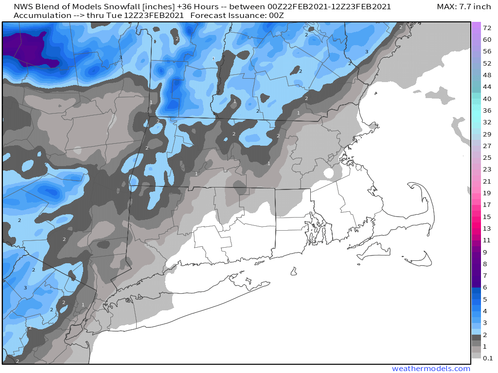
We start the week off with a weak low pressure system heading toward the region. For areas from Boston southward, this will be mostly rain, with a few snowflakes possibly mixed in at the start this afternoon. However, there will still be enough cold air in place for precipitation to start as snow north and west of Boston. Even here, a change to rain is likely, but there could be some minor accumulations, possibly as much as 1-2 inches, before the changeover, mainly in parts of southern and central New Hampshire, but possibly into the Merrimack Valley. Everything ends this evening as the storm pulls away.
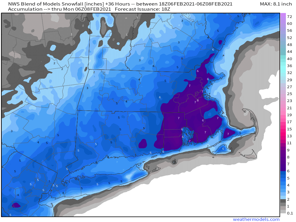
Not much snow is expected from today’s system. Image provided by Weathermodels.com
High pressure builds in for Tuesday and Wednesday with drier and milder conditions. In fact, parts of the area could make a run at 50 degrees on Wednesday. However, it won’t last long, as a cold front sweeps through at night, with a few showers and colder weather once again. High pressure builds back in for Thursday and Friday with temperatures that are closer to where they should be in late February, maybe even a little below normal again.
Wednesday could end up as a mild day across the area. Image provided by WeatherBell.
Another system moves in for next weekend, bringing some snow or rain to the region. Details are still a bit fuzzy this far out, but it doesn’t look like a big storm, and temperatures may end up cold enough for some snow, at least to start. Of course, given that it is six days away, things will change, so we won’t get into too much detail just yet. Conditions should improve on Sunday as the system pulls away, and it could turn quite mild again.
The models have differing ideas on what to expect next Saturday. Images provided by Pivotal Weather.
Monday: Cloudy and becoming breezy with light rain likely, starting as snow north and west of Boston. High 35-42.
Monday night: Showers end in the evening, some clearing late at night. Low 25-32.
Tuesday: More clouds than sunshine. High 37-44.
Tuesday night: Becoming clear. Low 27-34.
Wednesday: Sunny in the morning, clouds return in the afternoon, becoming breezy, a few showers are possible at night. High 41-48.
Thursday: Sunshine and a few clouds, breezy. High 36-43.
Friday: Mostly sunny, breezy, and colder. High 30-37.
Saturday: Cloudy with a chance of snow or rain. High 36-43.
The weekend starts off with some snow, and it looks like it might end with some snow as well, for at least part of the region.
The steadiest snow has been confined to the South Coast thus far. Loop provided by Weathertap.
We’ve got a series of weak low pressure areas passing south of the region tonight into Friday night. This will produce some occasional light snow well into Friday night, possibly lingering into Saturday morning for east-coastal areas, thanks to northeast winds behind the last of the storm systems. Along the South Coast, some sleet or rain may mix in for a while tonight and early Friday, keeping accumulations down a bit. For most of the region, this will be a general 3-6 inch snowfall, a little less along the South Coast, perhaps a little more across eastern and southeastern Massachusetts. Considering the snow is falling over the span of 24-36 hours, it will be an annoyance, but not that big of a deal.
The NWS Blend of models is still closest to our thinking for snowfall. Image provided by Weathermodels.com
While we may see some sunshine develop on Saturday behind the storm, an upper-level low pressure area will cross the Northeast, generating more clouds and perhaps a few snow showers. These shouldn’t produce much additional accumulation. We’ll clear out for Saturday night and Sunday as high pressure builds in. Temperatures will be on the chilly side, but nothing that extraordinary for the latter half of February.
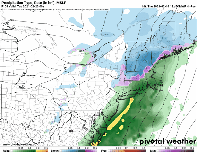
By Monday, the next storm system moves toward the region. With cold air in place, we’ll have snow developing across much of the region, but a change to rain seems likely, at least south and east of Interstate 95, possibly even farther inland. How far inland will depend on whether a secondary storm system develops to our south or not, which the models don’t agree on at this point. Either way, this system will be a fast-mover, and won’t contain a lot of precipitation, so even in places where it doesn’t change to rain, we’re not expected a lot of snow, possibly a few inches.
The models don’t agree on how far inland the rain/snow line will get on Monday. Images provided by Pivotal Weather.
Thursday night: Occasional light snow, possibly mixed with a little sleet or rain across the South Coast and Cape Cod. Low 21-28.
Friday: Occasional light snow, mixed with a little sleet or rain across Cape Cod and the South Coast. High 28-35.
Saturday: Plenty of clouds with a few sunny breaks, especially inland. A few snow showers are possible, especially in the morning in eastern areas. High 29-36.
Saturday night: Clearing. Low 12-19.
Sunday: Sunshine and a few clouds. High 28-35.
Sunday night: Becoming partly to mostly cloudy. Low 10-17.
Monday: Cloudy with light snow developing, changing to rain during the afternoon from Boston southward. High 35-42.
This shouldn’t be a surprise, since it’s February, but there’s snow in the forecast.
Today’s sunshine and cool temperatures are a product of high pressure building in across the eastern Great Lakes. However, as that high slides off to the east, low pressure, currently in the western Gulf of Mexico, will slowly make its way toward the region. However, it’s not as simple as a storm system passing off to the south and bringing in some snow. This will actually be a three-part system that lasts quite a while.
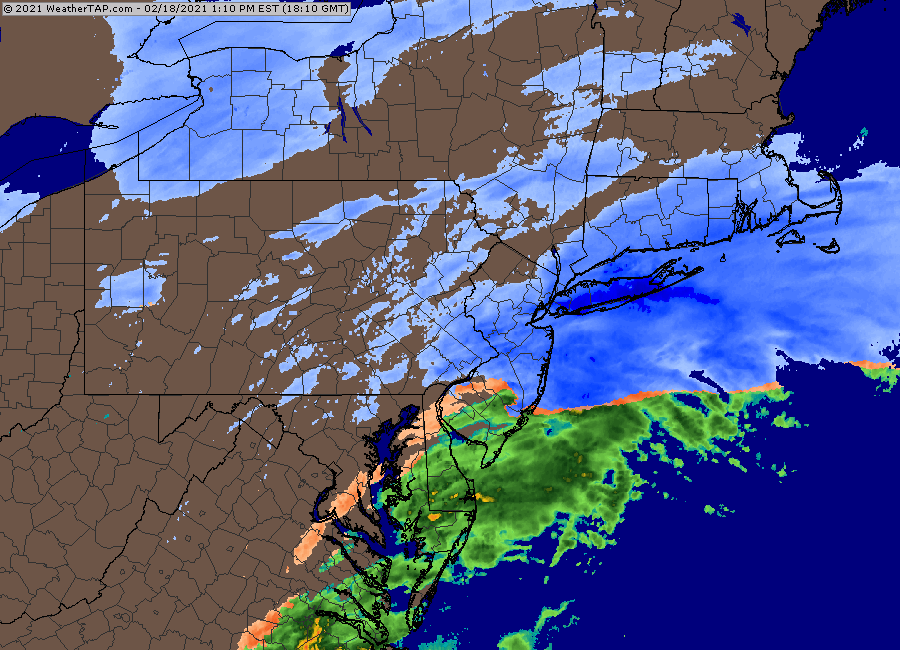
Aside from a few high clouds, most of the Northeast is enjoying sunshine this afternoon. Loop provided by NOAA.
The initial low pressure system will move off the Southeast coast and head northeastward, passing south of the area late Thursday and Thursday night. This will spread some light snow in Thursday afternoon and evening, mainly south of the Mass Pike. As that system pulls away, another weak system will emerge from the Carolina coast, spreading more snow in. This will overspread most of the area. Along the South Coast, we’ll see some milder air move in, especially aloft, which will likely result in some sleet or rain mixing in. That system pulls away early Friday, but yet another weak system follows in its wake, passing south of the area during the day on Friday, with even more snow expected, even down to the South Coast, as some cooler air filters in behind the previous system. That system finally pulls away Friday night, but with an upper-level low pressure system moving across the Northeast, some more snow showers are possible on Saturday.
It’s important to note that this isn’t your classic Nor’easter with a powerful system off the coast, strong winds, and bursts of heavy snow. Instead, we’re just left with a series of weak systems that will produce off-and-on light snow for a period of 24-to-36 hours across the region. Of course, even light snow will add up if it persists for that long, but this isn’t the “blockbuster” 1-to-2 feet that we sometimes receive at this time of year.
So, how much are we expecting?
Central NH (Concord): 2-4″ Southern NH (Manchester/Nashua): 2-5″ NH Seacoast/Merrimack Valley: 3-6″ MetroWest/MetroBoston: 4-7″ Southeastern Massachusetts/RI: 5-9″ South Coast: 4-7″ Cape Cod: 3-6″ (heaviest near the Canal)
The NWS Blend of Models is probably closest to our thinking right now. Image provided by Weathermodels.com
Another system may bring in some light snow or rain on Monday. We’ll have a little more detail on that in our Weekend Outlook tomorrow.
This week is going to be messy with not one but two different storms that will produce a variety of precipitation across the region.
We start off the week with plenty of clouds and some light snow and/or freezing drizzle this afternoon as a weak system passes well south of the region. However, another storm system will be moving out of the Tennessee Valley and heading our way. This is the same storm that wreaked havoc on Texas and the Southern Plains over the weekend. At one point over the weekend, all 254 counties in Texas were under a Winter Storm Warning. We’re not sure if that has ever happened before, but it’s certainly a rare event. That storm will head northeastward today, moving up the Appalachians. It will then redevelop south of Long Island tonight, and pass near or across southeastern Massachusetts Tuesday morning.
A variety of watches, warnings, and advisories are in effect across the Northeast ahead of the next storm system. Image provided by Pivotal Weather.
With the low passing to our south, cold air will remain in place for much of the region, mainly north and west of Boston. As milder air moves in aloft, we’ll see snow change over to sleet and then freezing rain this evening and tonight. Before it changes over, we’re looking at an inch or less of snow for much of Massachusetts and Rhode Island, with an inch, possibly 2 inches across southern New Hampshire. Once you get north of Concord, NH, several inches are possible before the flip to sleet/freezing rain. An extended period of freezing rain is possible in parts of the area, especially from the Merrimack Valley into Southern New Hampshire. This will obviously result in hazardous driving conditions, but also will increase the threat of power outages due to downed trees and wires from the weight of the ice. From Boston southward, we’re looking at mostly rain, with temperatures above freezing. How far inland that above-freezing air gets is still a question mark, but right now, we’re thinking that areas north and west of Interstate-95 will likely stay below freezing the entire time. Most of the models try to bring the warmer air all the way into the Merrimack Valley or even Southern New Hampshire. However, the models also tend to overestimate how quickly the cold air will erode, especially when there is snow on the ground. Plus, they have significantly underestimated the magnitude of the cold air that moved in across Texas and the Southern Plains over the last few days. For these reasons, we’re going to stay a little colder than the models. Across Cape Cod and parts of southeastern Massachusetts, cold air won’t be an issue, and in fact, temperatures could get to 50 or even warmer for a while Tuesday morning if the storm passes across southeastern Massachusetts instead of just to the south.
Everything winds down by early afternoon, then skies clear out, with colder air returning for Tuesday night and Wednesday as high pressure builds in. From Boston southward, this means that everything will quickly ice back over Tuesday evening as temperatures drop below freezing. Keep this in mind if you’ll be out an about, as many untreated surfaces will become slick. Although Wednesday will feature sunshine, it will be quite chilly, with temperatures likely staying in the 20s to lower 30s, which is as much as 10 degrees below normal.
Temperatures will be 5-10 degrees below normal on Wednesday. Image provided by Weathermodels.com
By Thursday, another system will approach the region, and this one also looks messy, but a little colder. This system will likely stay south of the region, but some milder air will move in aloft. So, once again, we’re looking at snow, changing to sleet and freezing rain, and possibly plain rain in some areas. The airmass ahead of this system will be a little colder than the one we have in place today, so we could be looking at more snow before the changeover, especially from the Merrimack Valley northward. However, this one could also feature a period of freezing rain across the interior. Details like this are nearly impossible to pin down 4-5 days in advance, so we’ll get into more detail towards midweek as things become clearer.
Thursday night and Friday are looking messy once again. Images provided by Pivotal Weather.
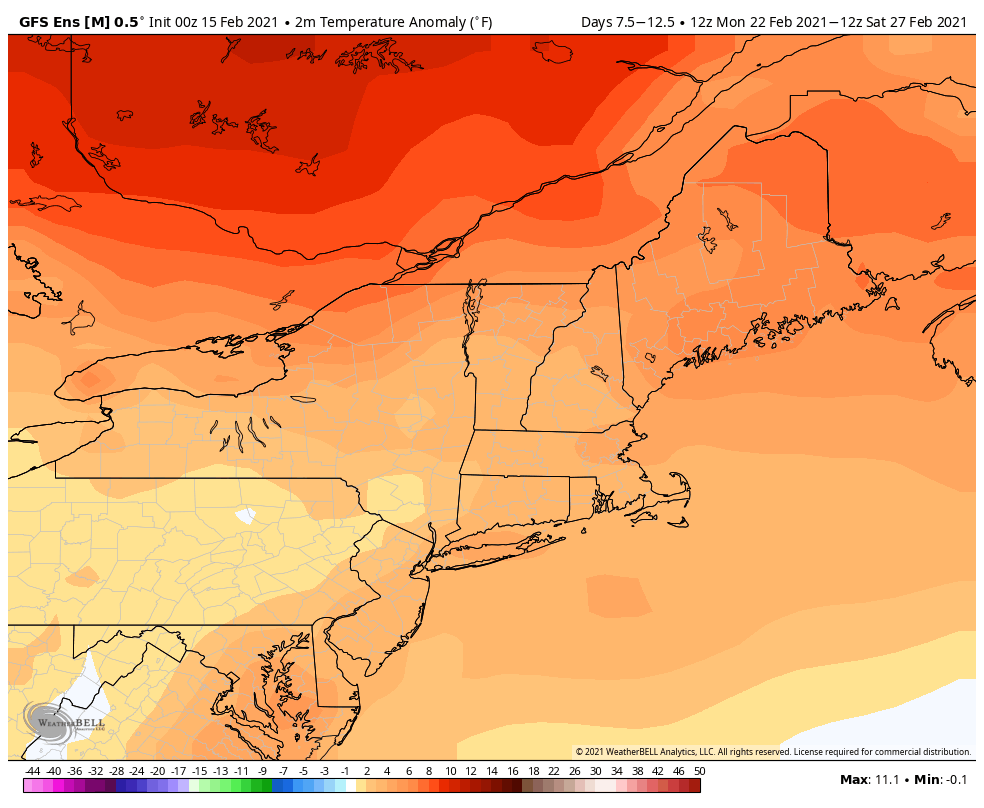
High pressure returns next weekend with drier and colder conditions once again. There are some signs that the colder weather we’ve been dealing with for much of the month could start to retreat in Canada next week, but that’s a long ways away, and things can still change.
Above normal temperatures next week? It’s possible, at least according to one model. Image provided by WeatherBell.
Monday: Cloudy with some light snow or snow showers, possibly mixed with a little sleet or drizzle, especially along the coast. High 27-34.
Monday night: Light snow during the evening, mainly from the Merrimack Valley into Southern New Hampshire, eventually changing to sleet and freezing rain, except precipitation falls mainly as rain south and east of Interstate 95. Low 25-32 during the evening, then temperatures may rise a few degrees overnight.
Tuesday: Freezing rain across the interior and rain in the coastal plain ending by early afternoon. High 30-37 north and west of Interstate 95, 38-45 south and east of I-95, potentially as warm as 45-55 across parts of southern Rhode Island, southeastern Massachusetts, and Cape Cod during the morning.
Tuesday night: Clearing, breezy. Low 14-21.
Wednesday: Sunshine and some late-day clouds. High 25-32.
Thursday: Cloudy, light snow is possible late in the day, possibly changing to sleet and freezing rain at night. High 26-33.
Friday: Snow, sleet, freezing rain, and rain ending in the morning, breezy. High 33-40.
Saturday: Intervals of clouds and sun, breezy, a few flurries are possible. High 25-32.
Who’s ready for some warmer weather? Well, you’d better head to Florida then, because it’s going to remain fairly chilly around here for a while.
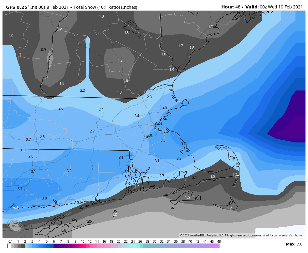
High pressure builds in tonight with some clearing and a chilly night expected. Temperatures will drop into the single numbers in many areas, with some subzero readings possible. Friday will remain chilly with high pressure in control, but we’ll see more clouds as an upper-level disturbance crosses the region. Clouds will become more prevalent on Saturday as a storm system starts to approach from the southwest. This will bring in some light snow for Saturday night into early Sunday. Temperatures won’t be as cold as tonight and Friday, so we’ll probably see some sleet and/or rain mixing in, mainly south of Boston. This will not be a blockbuster storm, with most places likely seeing just 1-2 inches of snow, possibly a little more in a few spots. High pressure returns on Monday with dry and cold conditions.
We’re not expecting much snow from the system on Sunday. Image provided by Weathermodels.com
Thursday night: Clear to partly cloudy. Low 2-9, a little warmer along the coast.
Friday: A mix of sun and clouds. High 21-28.
Friday night: Mostly cloudy. Low 5-12.
Saturday: Mostly cloudy. High 23-30.
Saturday night: Cloudy with some light snow developing. Low 13-20.
Sunday: Plenty of clouds with some light snow, possibly mixed with sleet or rain south of Boston, ending by early afternoon. High 28-35.
Sunday night: Mostly cloudy. Low 16-23.
Monday: Clouds and a few sunny breaks. High 27-34.
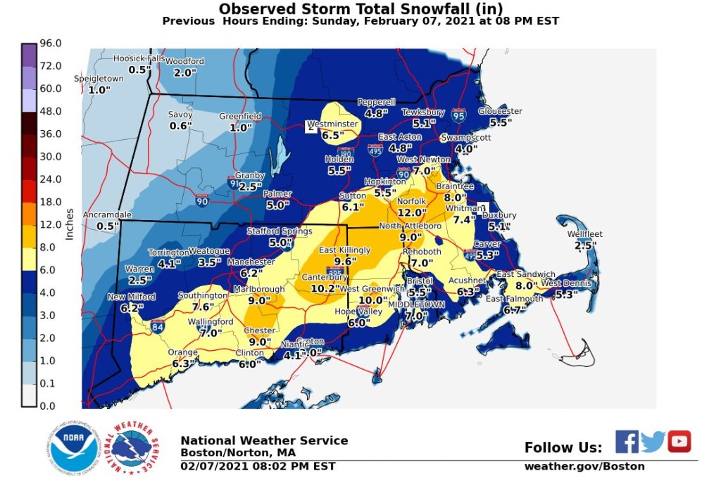
As you stare outside at all of the snow that fell yesterday, we’ve got some a tidbit to show you that despite what it looks like, Spring is right around the corner.
Our forecast for yesterday’s storm was nearly perfect, with only a few places exceeding our forecast. Image provided by the National Weather Service Office in Norton, MA
Yes, the Groundhog said we’re going to have six more weeks of winter, but we’ve got a sure sign for you that Spring is coming soon. Today is Red Sox Truck Day. It’s the day that the big truck leaves Fenway with all of the equipment to head to Fort Myers for Spring Training. Now, the team was largely forgettable last year, and this year isn’t looking a lot better, but if we’re talking about Spring Training starting soon (we hope), then can there really be a lot of winter left? (You really don’t want the answer to that question).
The first sign of spring is upon us – today is Red Sox Truck Day, when all of the equipment gets loaded up and shipped down to Fort Myers for spring training. Image provided by Boston.com
As for the weather this week, we’re starting off with sunshine and chilly conditions as high pressure settles into the region today. It won’t last that long, as we’re in a fairly active pattern right now, with systems moving in every 2-3 days, but none of them look to be substantial, at least for now. However, if you get enough little systems over a short period, and it does add up. Sort of like “Death by 1000 Paper Cuts.” The next one sends clouds in tonight, with some light snow likely on Tuesday, possibly mixed with rain along the South Coast. This will not be a big storm, but another 2-4 inches seems likely. It will likely fall during the day, so it could impact both the morning and afternoon commutes, for those of you not working from home.
Tuesday’s show should be on the light side. Image provided by WeatherBell.
High pressure builds back in for Wednesday with drier and cooler conditions. Again, this won’t last long, as another system approaches on Thursday. This storm will also pass south of the region, so we’re looking at another period of light snow sometime Thursday into Friday. The models differ a bit on the timing of this storm, and some of the models show the high pressure area to the north building in, which would keep the snow confined to areas south of the Mass Pike. These are details that can’t be worked out that precisely 5 days in advance, especially since the models have performed rather poorly more than 2-3 days in advance lately, so we’re just going to include a chance of snow for the entire region. Obviously, we have some time to work out the details. High pressure returns on Saturday with colder weather, but then another storm may move in for Sunday with more light snow or a wintry mix possible. It’s obviously WAY too early for any details on that system.
Monday: Sunshine with some afternoon clouds. High 22-29.
Monday night: Becoming mostly cloudy. Low 8-15.
Tuesday: Cloudy with light snow likely, possibly mixed with some rain along the South Coast and Cape Cod. High 27-34.
Tuesday night: Becoming clear to partly cloudy. Low 14-21.
Wednesday: A mix of sun and clouds. High 25-32.
Thursday: Cloudy with a chance of light snow. High 23-30.
Friday: Partly to mostly cloudy with a chance for light snow. High 22-29.
Saturday: Some early sun, then clouds return. High 24-31.
Sunday: Cloudy with a chance for snow or a wintry mix. High 20-27.
It seems as though we are getting a snowstorm after all tomorrow. It won’t be a big one, or a long-duration one, but it will impact your Sunday.
At the end of our Weekend Outlook, we mentioned the chance for snow on Sunday, but closed with this:
“Overall, not a big deal for most of us. Parts of the South Coast could see a few inches of snow depending on how far north the ocean storm actually gets, but otherwise, we’re not anticipating much accumulation across the region, unless things change in the next day or two.”
Well, things have changed. Low pressure will move off the Mid-Atlantic coastline tonight, and pass south and east of Nantucket on Sunday, farther north than we were thinking on Thursday. This will result in accumulating snow for most of the region, with this ending up as a moderate snowstorm far parts of southeastern Massachusetts.
Low pressure will pass south and east of the region on Sunday. Loop provided by WeatherBell.
Snow will develop from southwest to northeast during the morning, and from late morning into mid-afternoon, snow may be moderate to heavy at times, with snowfall rates of 1 inch per hour or more. The snow will start to wind down by late afternoon or early evening, just in time for the Super Bowl to begin. For most of us, this will be just a snow storm. However, for parts of Cape Cod and the Islands, there is a chance that some sleet or rain could mix in, which would keep accumulations down slightly.
So, how much are we expecting?
Central NH (Manchester/Concord): 2-4″ Southern NH/North-Central MA: 3-5″ NH Seacoast/Merrimack Valley: 4-7″ The Rest of Eastern MA/RI: 5-9″, except 3-6″ across the Outer Cape and Islands and the immediate east coast of MA
The NWS Blend of models is probably closest to our thinking right now. Image provided by Weathermodels.com
As was pointed out to us by a colleague for parts of Southeastern Massachusetts, this will be one of the biggest storms this area has seen in a few years. Using Middleboro as an example. they have only received 6 or more inches from a single storm twice in the last 3 years – 6.5″ December 2-3, 2019, and 8.5″ on March 4, 2019.
Beyond this, our next chance for some snow will be with another weak system on Tuesday. That storm will produce a little light snow, possibly rain south of Boston. However, given the performance of the models more than a day or two out, would you really be surprised if it becomes something bigger? We’ll have more on that in our Weekly Outlook Monday morning.
While the next few days will be anything but quiet around here, we’re not expecting anything extraordinary in the weather department either.
Low pressure will move up the St. Lawrence Valley on Friday. As is usually the case when that happens, we’ll have somewhat milder air move in along with some light rain. However, temperatures will still be cool enough that the rain may start as snow north and west of Boston if it moves in by midday. As the milder air takes over, the snow should change over to rain, but there may be enough snow to coat the ground in spots. We’re not expecting a lot of rain, nor are we expecting a big warmup, so don’t expect much of the snow from the storm earlier this week to melt.
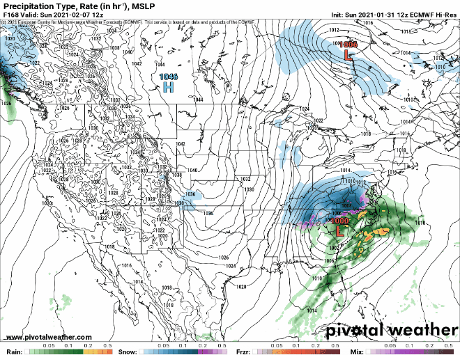
High pressure builds in behind the system for Saturday with some sunshine returning along with seasonable temperatures. The latter half of the weekend is where things get tricky. We’re watching two pieces of energy, one in the northern jet stream and another to the south. If these two were to meet up, or “phase”, we could end up with a big storm. Some of the models were hinting at that possibility earlier in the week, but it looks a lot less likely now. What is more likely to happen is that the southern system starts to develop but passes well south of the region, possibly delivering a little light snow to parts of the South Coast and maybe a little farther northward. The northern system will swing through here with some flurries or snow showers. Overall, not a big deal for most of us. Parts of the South Coast could see a few inches of snow depending on how far north the ocean storm actually gets, but otherwise, we’re not anticipating much accumulation across the region, unless things change in the next day or two.
The models do not agree on the placement of a storm system south of the region Sunday. Images provided by Pivotal Weather.
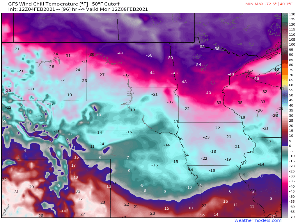
As we head into Monday, high pressure start to build back in with drier and colder weather. While it is likely the start of a colder pattern overall around here, temperatures will only be a little below normal for early February. The bulk of the cold air will stay well to our west. In parts of the Northern Plains and the Canadian Prairies, temperatures will be as much as 35-45 degrees below normal this weekend, with some areas dropping to 30-40 below zero at night, and daytime highs only in the -10 to -15 range. Wind chills will be colder than -50 in parts of the region.
By Monday morning, wind chills in parts of Minnesota and North Dakota will be colder than -50! Image provided by Weathermodels.com
Thursday night: Mostly cloudy. Low 17-24.
Friday: Cloudy with showers likely, mainly in the afternoon, starting as some wet snow north and west of Boston. High 37-44.
Friday night: Clearing. Low 21-28.
Saturday: Sunshine and a few clouds, breezy. High 32-39.
March is supposed to come in like a lion, and it still may, but for now, February is going to as well.
As you may have heard, it’s going to snow today. We’re not going to rehash that too much, since we just wrote a very detailed post about the storm Sunday evening, and our thinking really hasn’t changed much. Suffice to say, snow will become heavy at times this afternoon and tonight, changing to rain for the immediate coast and Cape Cod. It’ll start to wind down early Tuesday, but occasional snow showers and periods of light snow continue on Tuesday with rain eventually going back to snow near the coast. Strong winds this afternoon and tonight slowly diminish on Tuesday as well.
The NWS Blend of Models is still closest to our thinking with snowfall for the current storm. Image provided by Weathermodels.com
So, let’s get to what comes next. On Wednesday, the storm pulls away, heading towards Nova Scotia, but we may still have a few snow showers around, especially during the morning. Skies may start to clear out late in the day. The airmass behind the storm isn’t that cold, so unlike past storms, we don’t have to worry about another arctic blast freezing everything up. High pressure then builds in for Thursday and the sun should return, with temperatures right around where they should be in early February.
Average high temperatures in early February are in the middle to upper 30s across the region. Image provided by Weathermodels.com
Friday and the weekend are when things get interesting again. You may recall a few days ago when some of the tv meteorologists were talking about a big warmup and rainstorm around here for this coming Friday, which would help get rid of a lot of the snow we’re getting today. Well, that’s not quite what’s going to happen now. Yes, low pressure will still travel into the Great Lakes and then Ontario, passing well north and west of us, and temperatures will moderate a bit on Friday. However, temperatures will likely only get into the upper 30s to lower 40s, which is still a little above normal, but not the 50s some of the models were showing a few days ago. We’re also not looking at a lot of rain either. There will likely be some precipitation ahead of a strong cold front, and much of it will be rain, but it might not start as rain across the interior.
The cold front moves through Friday night and high pressure starts to build in with colder air once again. It won’t be as cold as what we had this past weekend, but temperatures will be near to perhaps a little below normal. That’s not the end of the story though. That cold front likely stalls out across the Southeast and then a wave of low pressure will move out of the Gulf of Mexico and start to ride up along the front. Some of the models are showing the potential for that system to bring in some more snow next weekend. It’s still 6-7 days away, and most of the models have not performed that well beyond 2-3 days for quite some time, so we’re not completely convinced of this yet, but it’s something we’ll start to focus on once we get our current storm out of the way. If it starts looking more likely, we’ll have more details in our Weekend Outlook Thursday afternoon.
The models have lots of differences in timing and track of a potential system next weekend. Images provided by Pivotal Weather.
Monday: Becoming windy with snow, heavy at times by late afternoon, changing to rain along the coast. High 28-35.
Monday night: Windy with snow, heavy at times inland, and rain from Cape Cod and parts of southeastern and coastal Massachusetts. Precipitation tapers off toward daybreak. Temperatures hold steady or rise a few degrees overnight.
Tuesday: Cloudy and breezy with periods of light snow and snow showers, except rain showers for southeastern Massachusetts. High 30-37, a little warmer across Cape Cod and possibly southeastern Massachusetts.
Tuesday night: Cloudy and breezy with additional snow showers possible. Low 21-28.
Wednesday: Cloudy with a few more snow showers possible early, some glimpses of sunshine are possible in the afternoon. High 29-36.
Thursday: Partly to mostly sunny. High 32-39.
Friday: Cloudy and breezy with showers developing, possibly starting as snow or a wintry mix north and west of Boston. High 38-45.
Saturday: Some early sun is possible otherwise mostly cloudy with a chance of snow or rain. High 33-40.
Sunday: Mostly cloudy with snow or rain possible. High 32-39.