Labor Day weekend has arrived – the unofficial end of summer, and at least one or two days will feel more like early fall.
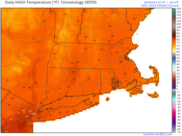
Temperatures are normally in the middle to upper 70s in early September. Image provided by weathermodels.com
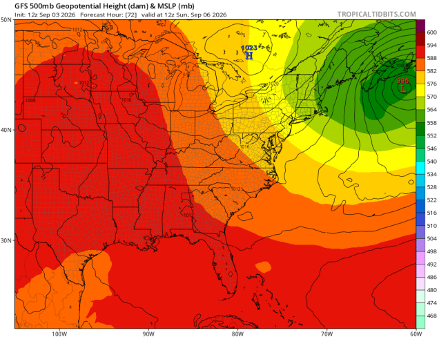
A cold front pushes through the region this evening, with any lingering showers ending, followed by some clear overnight. High pressure then builds in at the surface, but an upper-level low will take it’s time crossing the Northeast. The result will be morning sun, afternoon clouds, and a few pop-up showers on Friday, perhaps a few more on Saturday. A storm system south of Nova Scotia may send a few more clouds in late Saturday and Saturday night, but any rainfall should stay well to our east. With the upper low overhead, temperatures will be relatively cool on Saturday and Sunday, but will start to moderate for Monday with drier air as the upper-low slides off to the east.
Surface high pressure to our north and west and an upper-level low result in cooler weather this weekend. Image provided by Tropical Tidbits.
Thursday night: Showers end in the evening, some late night clearing. Low 60-67.
Friday: Becoming partly to mostly sunny in the morning, clouds return in the afternoon with a passing shower possible. High 77-84.
Friday night: Mostly clear. Low 58-65.
Saturday: Partly sunny, a few showers or a thunderstorm in the afternoon. High 69-76.
Saturday night: Partly to mostly cloudy. Low 52-59.
Sunday: A mix of sun and clouds, breezy. High 66-73.
Sunday night: Clear skies. Low 51-58.
Labor Day: Sunshine and a few afternoon clouds. High 71-78.
Rush wrote that lyric in the song “Time Stand Still”, but it’s appropriate for where we are now, as some cooler weather is on the way as we flip the calendar to September and the beginning of meteorological autumn.
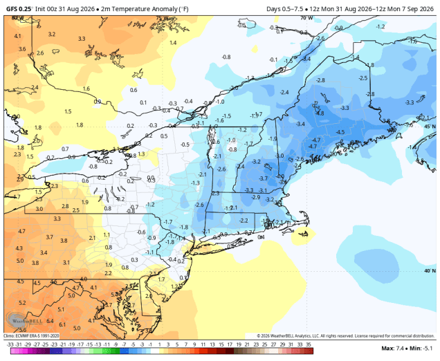
Temperatures will be below normal for much of this week. Image provided by WeatherBell.
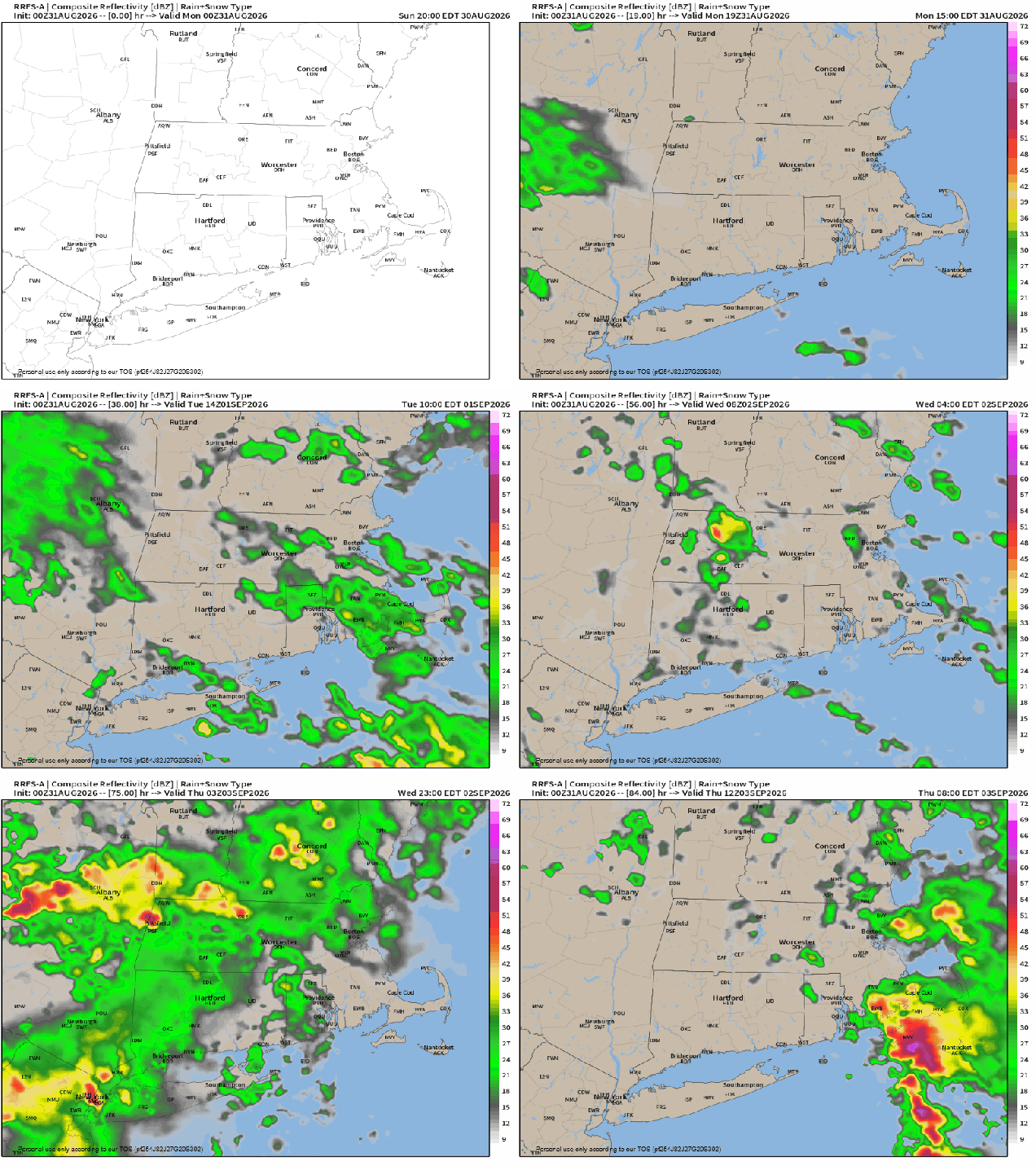
A backdoor cold front will drop southward today, likely stalling out just south and west of the region. The front will be accompanied by just a few clouds, but behind it, cooler air will settle in, especially near the east coast. A couple of waves of low pressure will ride along the front, keeping lots of clouds in place with some episodes of showers and a few thunderstorms at times between Monday night and Thursday. The last wave will lift the front northward as a warm front on Thursday, before a stronger cold front moves through late in the day, with some additional showers and thunderstorms. High pressure then builds in at the surface, but an upper-level low will settle into the Northeast for Friday and Saturday, possibly Sunday as well. The result will be sunshine each morning, some clouds build up, and a few spotty showers developing. For Labor Day, high pressure should result in dry and seasonably mild weather.
Several episodes of showers and thunderstorms are likely over the next few days. Loop provided by Weathermodels.com
Monday: A mix of sun and clouds. High 75-82, cooler near the east coast, especially in the afternoon.
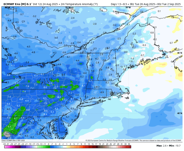
The final week of summer (traditional and meteorological) has arrived, and for the most part, the weather will be fairly nice, but a little on the cool side.
Below normal temperatures are expected for most of the upcoming week. Image provided by WeatherBell.
We start the week off with some rain across the Cape and Islands as a weak low pressure area passes by offshore. The rain should end during the morning, but we’ve got a cold front moving in from the west. We could see some sunshine, especially inland during the morning, but as the front moves in, we’ll see some showers and thunderstorms developing in the afternoon. They shouldn’t be that strong, but a few could produce some gusty winds and heavy downpours. They’ll quickly subside during the evening as the front pushes offshore, then high pressure starts to build in with cooler and drier conditions. However, we’ll also have an upper-level low pressure area moving in from the Great Lakes, and this will likely generate some clouds for Tuesday afternoon. It’ll probably be a little too dry for any showers to pop up, but it wouldn’t be a complete shock if a few days. Another disturbance rotating around that upper low will move in for Wednesday, with some morning sun followed by afternoon clouds, and this day may feature a better chance for some pop-up showers during the afternoon. Thursday looks like another dry day with some afternoon clouds and temperatures that remain a little below normal for late August.
A series of upper-level disturbances will influence our weather for much of the next week. Loop provided by Tropical Tidbits.
As we get to Labor Day weekend, we’ll see another low pressure area moving in on Friday, with another round of showers and possibly some thunderstorms. The system will take its time moving out as another upper-level low moves in, so Saturday may feature more clouds and a few showers, especially early, but we should see some improvement during the afternoon. Sunday looks pretty nice, but we’ll still have an upper-level low nearby, so expect more clouds, but for now, we’re not expecting more showers. High pressure builds in for Labor Day with dry and seasonably warm conditions, though some clouds are still likely as that upper-level low will be slow to depart.
Friday could feature some showers and thunderstorms, but much of the rest of the weekend looks dry. Images provided by Pivotal Weather.
Monday: Morning showers across Cape Cod, otherwise morning fog burns off revealing a mix of sun and clouds with some showers and thunderstorms likely during the afternoon. High 75-82.
Monday night: Any showers end in the evening, becoming clear overnight with some patchy fog. Low 56-63.
Tuesday: Morning sun, then some clouds pop up during the afternoon. High 72-79.
Tuesday night: Clear to partly cloudy. Low 52-59.
Wednesday: Partly sunny, chance for a few showers during the afternoon. High 70-77.
Wednesday night: Mostly clear. Low 51-58.
Thursday: Morning sunshine with afternoon clouds. High 73-80.
Thursday night: Partly cloudy. Low 53-60.
Friday: Partly sunny with showers and a few thunderstorms developing in the afternoon, tapering off late at night. High 71-78.
Saturday: Any lingering showers end early, some afternoon sunshine develops. High 68-75.