In Like a Lion…

The old saying is that March comes in like a lion and goes out like a lamb. We’ll see about how it goes out, but it certainly looks like it’s going to come in like a lion this year, but not in the usual way.

We’ve got some unseasonably mild air already in place, but it’s going to get even warmer as a warm front moves across the region tonight. It’ll be accompanied by some showers, and maybe even a rumble of thunder when it moves through. Some of the rain overnight may be locally heavy, but since most of you will be sleeping when it comes through, you won’t even notice. Also, with the warm front coming through, we’ll have our low temperatures this evening instead of in the morning, as temperatures will slowly rise overnight.

ndfd_record_hi_neng_2
Plenty of record highs are expected across the Northeast on Wednesday. Image provided by WeatherBell.


This brings us to Wednesday. Once that warm front moves across the area, even warmer air will flood into the region, with highs again soaring well into the 60s. The only limiting factor for tomorrow will be cloud cover, which there will likely be plenty of. If we can get some breaks of sunshine, it wouldn’t be a surprise if temperatures made a run at 70 in spots.

Warm temperatures aren’t the only story for Wednesday though. A strong cold front will be approaching from the west. While this front will bring an end to our warmth Thursday morning, it’s what happens ahead of it that is a bigger concern.

ma_swody2
A slight risk for severe weather exists across parts of southwestern New England on Wednesday, with a marginal risk for most of the remainder of Southern New England. Image provided by the Storm Prediction Center.


As is usually the case during the warmer months, with a warm and relatively humid airmass in place, the atmosphere will become unstable. Add in some lift ahead of the front and you get showers and thunderstorms. The bigger the clash in airmasses, but stronger the storms. That’s what will happen tomorrow. Thunderstorms will develop ahead of the front during the afternoon and evening hours and may even continue into the nighttime ahead of the front. Some of the storms could become quite strong, with heavy downpours, frequent lightning, and damaging winds. There is even the chance for an isolated tornado. Just last week, a tornado touched down in Goshen and Conway, Massachusetts – the first confirmed tornado ever during the month of February in the Commonwealth.


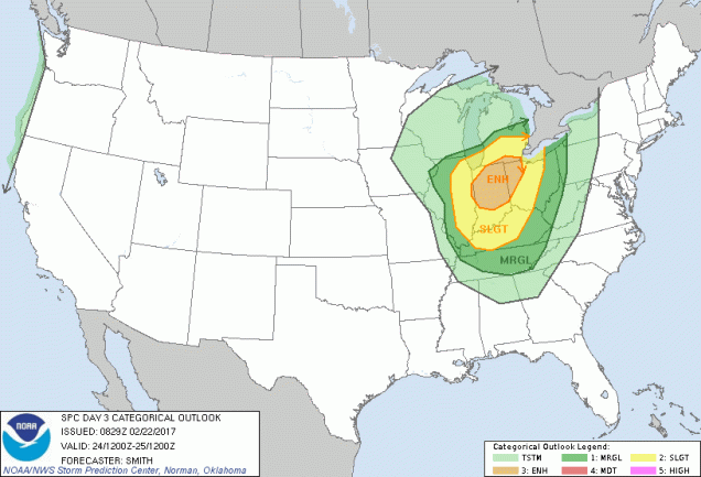
New England isn’t the only place where severe weather is expected though. In fact, what’s expected up here is minor compared to the Ohio and Mississippi Valleys. As that cold front moves into those areas later today into early Wednesday, widespread severe weather is expected to develop. Large hail, heavy downpours, damaging winds and several tornadoes are expected. This is more typical of April than the last day of February.

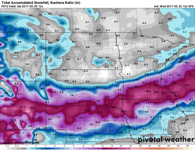
After this front moves offshore, things quiet down a bit, and we get back into weather that is more typical of early March, especially here in the Northeast. We do need to keep an eye on Friday though. An Alberta Clipper will be diving southeastward from the Great Lakes. It will pass south of New England during the day on Friday and into Friday morning. While the majority of the forecast models keep the system far enough south of have little to no impact on us, not all of them do. So, there is the chance for some light snow, especially south of the Mass Pike, on Friday. We’ll have more on this later in the week if the threat materializes.

Weekly Outlook: February 27-March 5, 2017

Le Monstre
Please remain seated until the ride has come to a complete stop. Image provided by Coastergallery.com


Sure, it felt warm enough to go to an amusement park at the end of last week, and it will again in a few days. But, much like the rollercoaster above, things will go downhill too.

The week starts off with us going up the incline, as temperatures slowly rise over the next few days. While today will be sunny, thanks to high pressure, clouds will dominate Tuesday and Wednesday as a storm system approaches from the west. A few showers are possible Tuesday morning, but there’s a better chance Tuesday night into Wednesday as a warm front crosses the region. A cold front moves through Thursday morning, which means we start the downhill part of the ride at that point. This is where some of you will start screaming, because even though the rain will end and the sun will return, it will be windy and colder, with temperatures dropping all day. But wait, the thrills don’t end there! An Alberta Clipper comes through the region on Friday, bringing us some light snow (some of you are probably screaming again right now). This isn’t set in stone just yet, as some models have the storm staying just to our south, so we’ll need to keep an eye on this as the week goes on. High pressure builds in for the weekend, with chilly temperatures expected on Saturday. We start the next uphill climb on Sunday as temperatures start to head back up once again.

ndfd_record_hi_neng_3
Record highs again on Wednesday? Certainly looks like a possibility. Image provided by WeatherBell.

Monday: Plenty of sunshine, breezy. High 48-55.

Monday night: Increasing clouds, chance for a few showers towards daybreak. Low 30-37.

Tuesday: Mostly cloudy, a few showers are possible in the morning. High 49-56.

Tuesday night: Cloudy with periods of rain and showers likely. Low 39-46.

Wednesday: Breezy with mild with showers likely, maybe even a thunderstorm. High 58-65.

Thursday: Becoming partly to mostly sunny, windy, and colder. High 45-52 early, then temperatures drop throughout the day.

Friday: Mostly cloudy with a chance of light snow. High 31-38.

Saturday: A mix of sun and clouds, windy. High 26-33.

Sunday: Partly to mostly sunny. High 42-49.

Record Highs, Blizzard Conditions, and Severe Weather – February in the Nation’s Midsection

“In the Spring, I have counted 136 different kinds of weather inside of 24 hours.” – Mark Twain

It’s not quite spring yet, but this quote is still appropriate. Much of the nation’s midsection has been enjoying temperatures more typical of April than February for the past week, with a few hundred record high temperatures broken. That is about to change, as Mother Nature will remind the region that is still February.

ndfd_record_hi_mc_1
Numerous record highs are expected across the Plains and Midwest again today. Image provided by WeatherBell.

Of course, they will still have one more warm day today, with highs well into the 60s and 70s likely setting more records. However, a cold front will sweep across the region, bringing an end to the record heat, and setting the stage for a snowstorm.

The low pressure system that brought more rain to California over the past couple of days will head eastward, bringing some snow into the Rockies today. As that system moves into the Plains on Thursday it will start to strengthen, drawing moisture northward from the Gulf of Mexico while cold air flows southward on the backside of the storm into the Northern Plains. Where these airmasses meet, snow will develop across the Central Plains states. The snow will be accompanied by winds of 20-30 mph, gusting to 40 mph or more at times, resulting in near-blizzard conditions across portions of South Dakota, Nebraska, southeastern Wyoming, and eastern Colorado on Thursday.

snku_acc-us_nc
More than a foot of snow may fall in a swath from the Plains into the Upper Midwest. A lot of these same places are going to be in the 60s and 70s today. Image provided by Pivotal Weather.

As the system heads eastward, snow will move into portions of the Mississippi Valley and the Upper Midwest on Friday. The heaviest snow looks to stay just south of the Twin Cities, but even there, moderate to heavy snow is likely. By the time the storm moves out on Saturday, a foot or more of snow is possible in a swath from the Central Plains into the Great Lakes.

Snow isn’t the only threat from this system. As the storm moves eastward, record warmth will remain in place across the Midwest. With warm, moist air in place and a strong cold front approaching from the West, strong to severe thunderstorms are possible across portions of the Lower Great Lakes and Ohio Valley on Friday. Some of the stronger storms that form may contain damaging winds, hail, and possibly tornadoes.

day3otlk_0830
The Storm Prediction Center has already highlighted the Midwest as an area to watch for severe weather on Friday. Image provided by NOAA.

The system will continue to move eastward, bringing some rain to the East Coast on Saturday, which may cause problems for hockey fans in the Steel City. The next NHL Stadium Series game (Ed – Enough with the outdoor games already. It jumped the shark a long time ago), is scheduled for Saturday at 8pm between the Pittsburgh Penguins and Philadelphia Flyers. The daytime hours will likely be mild with rain, but the rain may change to snow late in the day as temperatures tumble. Either way, it won’t be a pleasant night for fans to be sitting in the stands at Heinz Field. Here at Storm HQ, we despise the Flyers, so we hope their fans not only have to sit through the weather, but watch their team get thumped too.

scott-wilson-jpg-size-custom-crop-819x650
That’s former UMass-Lowell RiverHawk (and StormHQ favorite) Scott Wilson hoisting the Stanley Cup last June. Image provided by Toronto Star.

Once it gets past Pittsburgh, that front will head eastward, bringing some rain to us here in New England. It probably won’t be a lot of rain, but temperatures will be in the 50s and possibly 60s ahead of the front on Saturday. Once the front comes through, Sunday will be windy and colder.

Weekly Outlook: February 20-26, 2017

After a couple of warm days, those rapid-fire snowstorms sure seem like they happened awhile ago, right? OK, so you still can’t see your lawn, but the good news is, you probably will within a few days. That’s right, the warm weather will continue and there’s no snow in the picture.

spring-training
Another sure sign that spring is just around the corner. Before you know it, you’ll see pictures of David Price throwing at Fenway, not Fenway South. Image provided by Redsox.com


The week starts off with high pressure keeping us dry for Monday and Tuesday. Monday will be cooler than the weekend was, but temperatures will still be right around or maybe a little above where they should be for mid-to-late February. We’ll start to warm up on Tuesday as high pressure moves offshore, but a weak system may bring in some showers Tuesday night. Then it turns warmer again. Wednesday should see highs in the 50s, and we may even make a run at 60 on Thursday, with some record highs possible. A weak cold front moves through late Thursday, but behind it, temperatures should remain quite mild for Friday and Saturday, though Saturday is also looking wet, as a storm system moves into the Great Lakes. That storm drags a cold front through Saturday night, and Sunday will be windy and colder. Of course, when we say “colder”, we mean,”right about where we should be in late February.”

ndfd_record_hi_neng_4
Thursday is looking quite mild with some record highs possible. Image provided by WeatherBell.


Monday: Partly to mostly sunny. High 35-42.

Monday night: Clear to partly cloudy. Low 18-25.

Tuesday: Morning sunshine fades behind increasing afternoon clouds. High 37-44.

Tuesday night: Cloudy with scattered showers. Evening low 28-35, then temperatures rise overnight.

Wednesday: Plenty of clouds with some sunny breaks. High 47-54.

Thursday: More clouds than sunshine. High 54-61.

Friday: A mix of sun and clouds. Showers likely at night. High 48-55.

Saturday: Cloudy and breezy with showers likely. High 50-57.

Sunday: Sunshine and some afternoon clouds, breezy, and cooler. High 38-45.

Just because this week is going to be warm, doesn’t mean that winter is over. We’ve had some sizable snowstorms around here in March and April, and even on rare occasions into May. There are some indications that it may turn cooler again as we head into early March.

(Did we mention that Red Sox Opening Day is 6 weeks from today?)

Here We Snow Again

We had a blizzard on Thursday and some light snow this morning. So, you’re all set with snow for a while, right? Good, you get a 24-hour break. We’ve got another storm coming for Sunday and Monday, and this one is looking like it will be another significant one.

Low pressure currently moving across the Plains states will move into the Ohio Valley tonight, then off the Mid-Atlantic coastline later on Sunday, passing just south of New England. It is then expected to slow down in the Gulf of Maine Sunday night and Monday while rapidly intensifying. Cold air is already in place today, and some spotty freezing drizzle or flurries are possible this evening into Sunday morning. The steadier precipitation from the storm should arrive around midday Sunday, in the form of snow, and may quickly become moderate during the afternoon hours. A coastal front will likely set up once again, with temperatures in the lower to middle 30s to the east of it, and upper teens to lower 20s west of it. As this front pushes inland, snow will change to rain during the late afternoon  or evening from Boston southward. Inland, we may see a little freezing rain or sleet mix in, but it should be mainly snow. As the storm begins to intensify in the Gulf of Maine Sunday night and Monday, this coastal front will collapse back towards the coast, changing everything back to snow, as gusty northerly winds send cold air back across the region. Snow continues into Monday morning, before tapering off around midday, though some snow showers may continue into the afternoon.

nam-refcmp_ptype-us_ne-2017021112-loop
Forecast from the NAM model for the upcoming storm. Loop provided by Pivotal Weather.

Having said all that, there are still a few details to be worked out:

1. How close does the storm come to the South Coast/Cape Cod.
2. How rapidly does the storm intensify in the Gulf of Maine.
3. How close to the coast does the storm slow down in the Gulf of Maine.

We need to resolve the factors to get a truly accurate forecast, but unfortunately, most of that won’t be known until the storm is ongoing. We are fairly sure that the strong winds will be confined to coastal areas, and mainly on Monday as the storm really intensifies to the east. Sustained winds of 25-35 mph with gusts to 50 mph or more are possible, especially from Cape Ann to the South Shore and Cape Cod.

So, by now, you’re wondering, how much snow this time? Here’s what we’re thinking:

Cape Cod: 1-3″, mainly Monday from the backlash behind the storm.
South Shore/Boston/Providence: 4-8″, possibly a little more, especially the further inland you get
MetroWest: 5-10″
Merrimack Valley: 8-12″
Southern NH/MA North Shore: 10-14″
NH Seacoast/Southern Maine: 12-16″

hires_snow_boston_61
The High Resolution NAM model most closely resembles our forecast for the upcoming storm. Image provided by WeatherBell.

We may revise this forecast late tonight or Sunday morning, if time allows. Also, just to give you fair warning, we may be dealing with yet another snowstorm in the Wednesday/Thursday time frame.


More Snow This Weekend?

Have you finished cleaning up your driveway from the blizzard yet? Good, because we’ve got a 1-2 punch coming this weekend with more snow, though the 2nd storm, while stronger, may end up as rain for a portion of the area.

latest_snow_anal_box
How much snow actually fell during yesterday’s blizzard. Our forecast worked out almost perfectly. Image provided by National Weather Service – Taunton.

Don’t let today’s sunshine fool you, it’s going to snow again tonight. A Saskatchewan Screamer (also known as an Alberta Clipper) will race this way, spreading clouds back in late today. There will be little wind associated with this storm, so we’ve got that going for us. Light snow will develop around midnight and continue through the morning, tapering off an ending around midday. Most of us will see between 1 and 3 inches from this storm, with a few 4 inch totals possible. That’s not a big deal, right? Especially after what we got yesterday.

hires_snow_boston_37
Just some light snow is expected late tonight and Saturday morning. Image provided by WeatherBell.

After that, we turn our attention to Sunday, because that might be a bigger deal. That storm, like so many of the other ones we’ve had this winter, will likely not be all snow for everyone. However, where it does stay all snow, we could be looking at several inches of heavy, wet snow – the kind that nobody likes to shovel.

Low pressure will head into the Ohio Valley then towards the eastern Great Lakes this weekend. It will then redevelop off the Mid-Atlantic coastline and head east-northeastward, passing near or over Cape Cod, because really starting to intensify in the Gulf of Maine. How close it comes to the Cape and how quickly it starts to intensify are the biggest things that will impact our forecast. We’ll try to iron out those details in the next 24 hours, and have another post tomorrow, after the first system winds down.

Snowy Thursday Expected

“Luck. Runs. Out.” – Metallica

If you’ve been enjoying the relatively snowless and mild winter, then the opening line to the Metallica song “All Nightmare Long” is an appropriate line today, because your luck has run out. We’ve got a snowstorm coming tomorrow, and it’s going to impact both the morning and evening commutes, so plan ahead.

A cold front is moving across the region this afternoon, replacing last night’s unexpected cold air with milder air. Yes, that doesn’t sound right, but it’s what’s actually happening. As it moves offshore, it will stall out south of New England and high pressure will build in to our north, replacing the relatively mild air of this afternoon with more seasonably cold conditions tonight. At the same time, a wave of low pressure will ride along our stalled out cold front across the Tennessee Valley and into the Mid-Atlantic states. Once it moves off the coast early Thursday, it will intensify as it passes south and east of New England. With cold air settling in, and low pressure passing just south of New England, you get a snowstorm. It won’t be a blockbuster storm, since it’ll be moving too quickly, but we’re still looking at moderate to heavy snow.

gfs-prateptype_cat-us_ne-2017020812-loop
GFS model forecast for the progression of our Thursday storm. The darker blues are moderate to heavy snow. Loop provided by Pivotal Weather.

OK, time for some specifics. First the timing. This will be a 10-12 hour storm for most of us. The snow should develop right around the morning commute, roughly the 6-8am time frame. It should end right around the evening commute, roughly the 6-8pm time frame. The worst of the storm will be between about 10am and 4pm, when snow could fall at the rates of 1-2 inches (or more) per hour.

Next up – temperatures, since they have an impact as well. We’re going to have a boundary set up across eastern Massachusetts that is called a coastal front. We had the same thing happen last night. East of the front (right along the coast), temperatures will be in the upper 20s to lower 30s, resulting in a wet, heavy snow. West of the front, temperatures will be in the upper teens to lower 20s, resulting in a much drier, fluffier snow. Right along this boundary is usually where the heaviest snow falls. So, where does that front set up? Right now, it looks like somewhere right along I-95 across eastern Mass.

hires_t2m_boston_30
Temperature forecast for Noon Thursday based on the WRF model. Note the sharp temperature gradient across eastern and southeastern Massachusetts. Image provided by WeatherBell.

Next up, the winds. Strong winds will likely be confined to eastern Massachusetts, especially along the coast, as always. Sustained winds of 20-30 mph are possible near the coast, with some gusts to 50 mph. Away from the coast, we’re looking at gusts of 20-30 mph. Nothing like some of the worst storms we’ve seen, but it’ll creating blowing and drifting, reducing visibility at times.

So, that leads us to the part you’re all most interested in – how much snow are we going to get? For most of us, this will be a moderate snowfall event. Here’s the breakdown for what we’re thinking:

Central NH (Concord): 3-6″
Southern NH (Manchester/Nashua/Portsmouth): 4-8″
Merrimack Valley/Central MA (Lawrence/Lowell/Fitchburg/Worcester): 5-10″
Cape Cod: 5-10″ (maybe a little less on the Outer Cape/Nantucket)
North Shore/SE Mass (Beverly/Plymouth/Fall River): 6-12″
Rest of Eastern MA/RI (Boston/Providence/Brockton/Framingham): 7-14″ with isolated heavier totals possible.

6zgfs
This model (the GFS) most closely resembles our thinking for snowfall across the region. Image provided by Pivotal Weather.

Once the storm goes by, we’re looking at a breezy and cold day on Friday, with temperatures likely staying in the teens or lower 20s across the entire area. Then, Friday night and Saturday brings another Saskatchewan Screamer (Manitoba Mover? Albert Clipper?) which could drop a quick 2-4 ” of snow. There’s another storm right behind that for Sunday night into Monday, but the models are indicating that storm could feature more rain than snow. We’ll keep an eye on it anyways. The active pattern likely continues into next week as well.

Weekly Outlook: February 6-12, 2017

tom_brady_super_bowl_patriots
All is right in the world again. Image provided by Associated Press.

Well, looks like there’s going to be yet another parade in the City of Boston. It also looks like Mayor Marty Walsh didn’t consult with any meteorologists before announcing it, because the weather on Tuesday at 11am doesn’t look pretty at all. But Tuesday’s not the only day we need to worry about, there’s also Thursday (which could be a bigger threat) along with Saturday and Sunday. So, let’s get right to it.

The week starts off with high pressure on Monday, giving us some sunshine, but cooler temperatures. By Tuesday, low pressure starts heading into the Great Lakes, with a warm front extending eastward. As is typical of this time of year, the warm front will have a hard time moving northward, which will create a mess across inland areas, as cold air remains trapped at the surface while warmer air moves in aloft.From Boston southward, this will be mainly a rain storm, with some snow possible at the start Tuesday morning. Inland though, especially north and west of 495, it’ll be a much different story. Accumulating snow is likely, which a change to sleet and freezing rain Tuesday evening, The wintry mix may continue through much of the overnight, especially across southern NH, before the warmer air finally moves in Wednesday morning, allowing a change to plain rain before it ends around midday. We’re not looking at a lot snow, mainly 1-3″ in most spots, maybe a little more into southern NH, but the sleet and freezing rain could make for some slippery travel Tuesday night. If you’re heading in for the parade, expect some snow changing to rain, gusty easterly winds, and temperatures in the middle 30s.

snku_acc-us_ne
Snowfall forecast through Wednesday afternoon from the NAM model. Image provided by Pivotal Weather.

Once that storm moves out, we turn our eyes to the south for Thursday. Most of the models show a storm system moving off the Southeast coast and heading northeastward. Most of the models also have it passing close enough to spread some snow into at least southern New England. The question is, how close does it get? That could mean the difference between a few inches from Boston southward (as some models show), , 3-6″ across most of eastern New England as another model shows, or a widespread 6-12″ across the entire region, as another model is currently showing. For now, we’re going to lean towards the lighter side, but we’ll have to keep a close eye on the models for the next few days to see which way they are trending. As usual, if it looks like a threat, we’ll write another post about it.

Once that system goes by, then high pressure builds in for Friday with much colder conditions, but an Alberta Clipper will head our way for Saturday. This will bring in some light snow, but shouldn’t be a big storm. Another system quickly moves out of the Great Lakes behind that one for Sunday, but this one looks warmer, with more rain than snow. However, it’s nearly a week away, so a lot can and will change, and we’ll need to keep an eye on this one too.

ca3rvpsw8aemizi-1
Sick of winter already? Today is Red Sox Truck Day! Spring training isn’t far behind. Image provided by Boston Herald.

Monday: Plenty of sunshine to start, clouds start to move in during the afternoon. High 28-35.

Monday night: Becoming cloudy, some flurries or freezing drizzle are possible. Low 21-28 in the evening, then temperatures hold steady or slowly rise overnight.

Tuesday: Snow developing, quickly changing to rain from Boston southward, gradually changing to a mix of sleet and freezing rain north and west of Boston late in the day. High 29-36 north and west of I-95, 36-43 south and east of I-95.

Tuesday night: Freezing rain continues across southern NH, changing to plain rain close to daybreak, elsewhere, light rain is expected overnight. Temperatures slowly rise across the region.

Wednesday: Showers ending around midday, otherwise remaining mostly cloudy. High 41-48 north and west of I-95, 48-55 south and east of I-95.

Thursday: Cloudy with a chance of snow. High 26-33.

Friday: A mix of sun and clouds, chance for a few snow showers. High 18-25.

Saturday: Cloudy with a chance for some light snow, possibly changing to rain across Cape Cod and the South Coast. High 30-37.

Sunday: Cloudy with a chance of rain or snow. High 32-39.