Yup, the hype train has left the station again and is rolling down the track. You may have heard that there’s a storm coming later this week. We’ll set the record straight between hype and reality, fact and fiction, in this outlook.
The first half of the week, also known as the last 3 days of February (and the last 3 days of meteorological winter) will actually be quite pleasant. High pressure will be in control with sunshine and mild temperatures. It’s not the early taste of spring that we had a week ago, but we doubt there will be many complaints. After that, things start to get complicated.

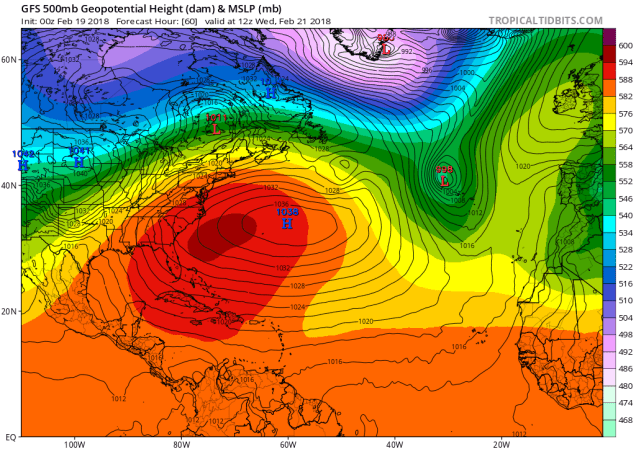
A “blocking” pattern will set up across the Eastern US. Normally, the jet stream flows west to east, steering storms across the country. When there’s a dip in the jet stream (a trough), we tend to have colder than normal temperatures, along with stormier conditions. We’ll have one of those troughs move into the East later this week, and it will eventually break off from the jet stream (called a “cut-off low”). At the same time, a large upper-level high pressure area will set up shop over Greenland. This will block the eastward progression of storms, meaning that the storm we’re expecting later this week won’t be in a hurry to leave. However, it could also be a good thing. How? If the ridge of high pressure continues to build in, it could deflect that storm farther to the south. Good for us, but bad for places like New York City, Philadelphia, or even Washington.
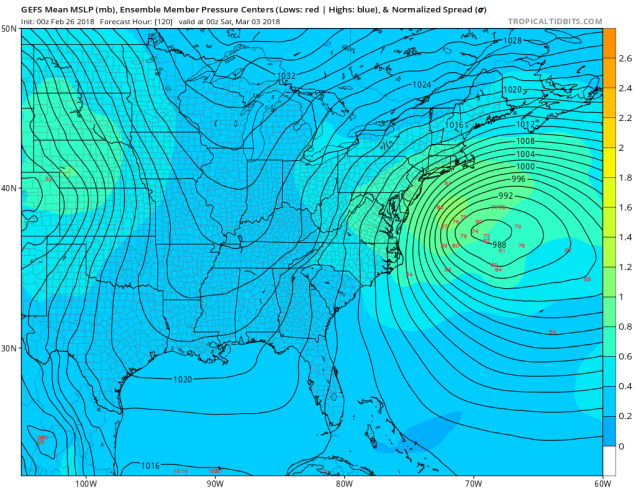
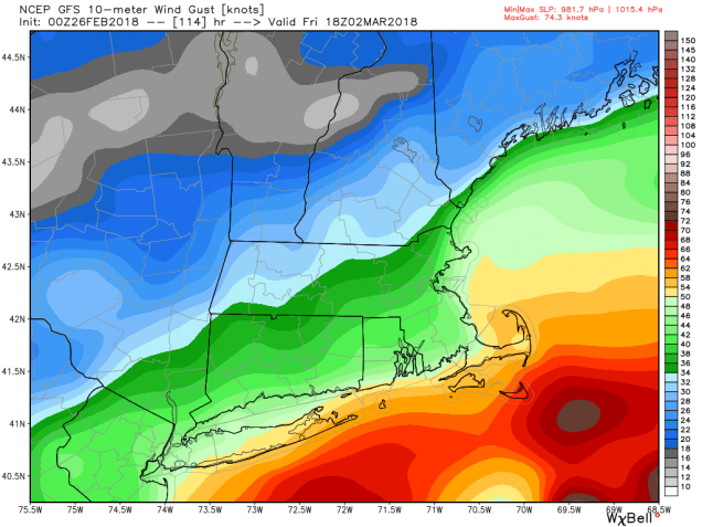
The models still haven’t come to a consensus on what will happen for the end of the week. There are several things that we need to figure out before we can come up with a forecast that we’ll have any confidence in. What are those factors? Where will the low pressure area track? How strong will it be? How much cold air will be in place before the storm arrives and when it’s impacting the region? How strong will that high pressure area to the north be? These details will likely take a few more days to be resolved. So, if you hear others, especially in the media, talking about the “3-day storm” or the “snowstorm” that will impact us later this week, take it with a giant grain of salt. Nobody, including us, can say with any degree of confidence, what will happen. We could have heavy rain, heavy snow, strong winds, or all of the above. The only thing we can be reasonably confident about is the fact that some coastal flooding seems likely. The highest tides of the month are expected at the end of the week, and with a storm of some sort off the East Coast, that will likely lead to some coastal flooding across parts of the area. Things should start to improve over the weekend, but even that will depend on the progression of the storm.
Monday: Early clouds, then becoming mostly sunny and mild. High 47-54.
Monday night: Clear skies. Low 26-33.
Tuesday: Plenty of sunshine. High 46-53.
Tuesday night: Clear to partly cloudy. Low 31-38.
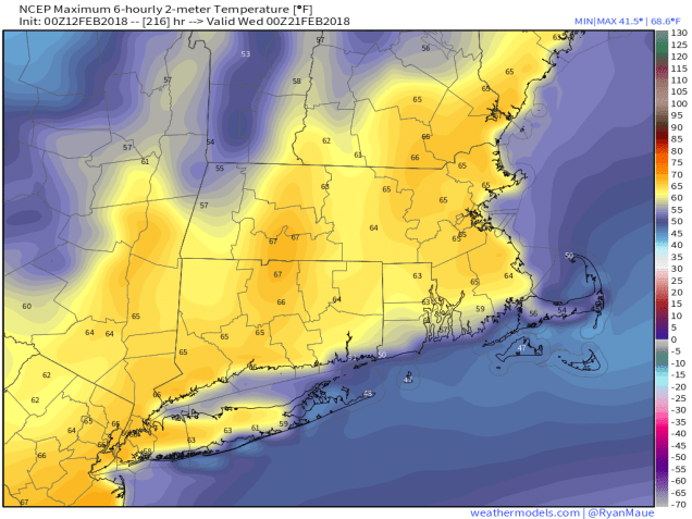
Wednesday: Some early sun, then clouds filter in as the day goes on. High 52-59.
Thursday: Mostly cloudy and becoming breezy with some rain or snow possible late in the day and at night. High 46-53.
Friday: Windy with rain or snow possible. High 35-42.
Saturday: Windy with a chance for more rain or snow, especially early. High 36-43.
Sunday: More clouds than sun, breezy, chance for a few snow or rain showers. High 35-42.