Dry and warm weather continues for a few more days, but changes are coming towards the end of the week.
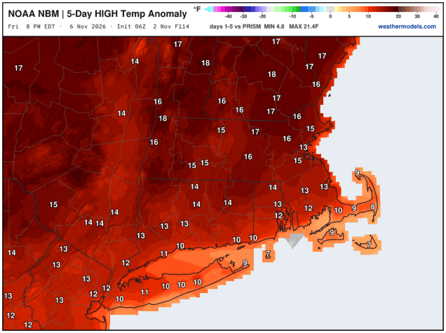
High pressure sits offshore for the next several days, keeping us dry through Wednesday with southwest winds bringing warmer air back in. Many places could top 70 each of the next few days. Changes start on Thursday as a cold front approaches from the west. It will remain warm, but we could see some showers by late in the day, more likely at night. The front will slow down and stall out close to the region, possibly just offshore, on Friday as a wave of low pressure rides up the front and intensifies. This will bring in some rain on Friday, but how much depends on whether the system tracks just offshore, or right across eastern parts of the region. Either way, Friday looks fairly wet, but still warm, depending on where the front is. The system slowly moves into the Gulf of Maine on Saturday, with some additional showers and breezy conditions developing. Sunday’s weather will be determined by how quickly the storm intensifies over eastern Canada and how quickly it pulls away. Showers may linger across parts of the region, but we could also see some clearing is the storm pulls away fast enough. It will likely be breezy and cool either way.

Monday: Sunshine with some afternoon clouds. High 64-71.
Monday night: Partly cloudy. Low 44-51.
Tuesday: Partly sunny. High 65-72.
Tuesday night: Partly cloudy. Low 45-52.
Wednesday: Mostly sunny. High 68-75, cooler near the South Coast and Cape Cod.
Wednesday night: Partly cloudy. Low 50-57.
Thursday: Becoming mostly cloudy, showers possible late in the day. High 66-73.
Thursday night: Cloudy with showers likely. Low 53-60.
Friday: Periods of rain and showers. High 63-70.
Saturday: Cloudy with more rain likely. High 58-65.
Sunday: Intervals of clouds and sun, lingering showers possible, breezy. High 54-61.

