This does not look like a good week for a vacation.
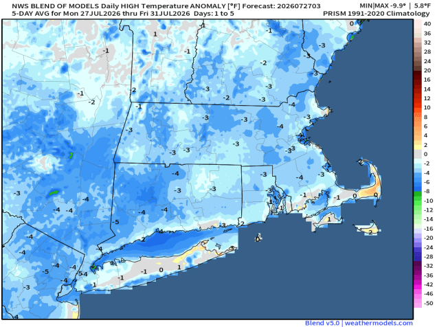
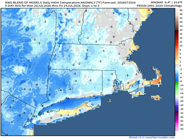
Temperatures will be below normal for the next few days. Image provided by weathermodels.com.
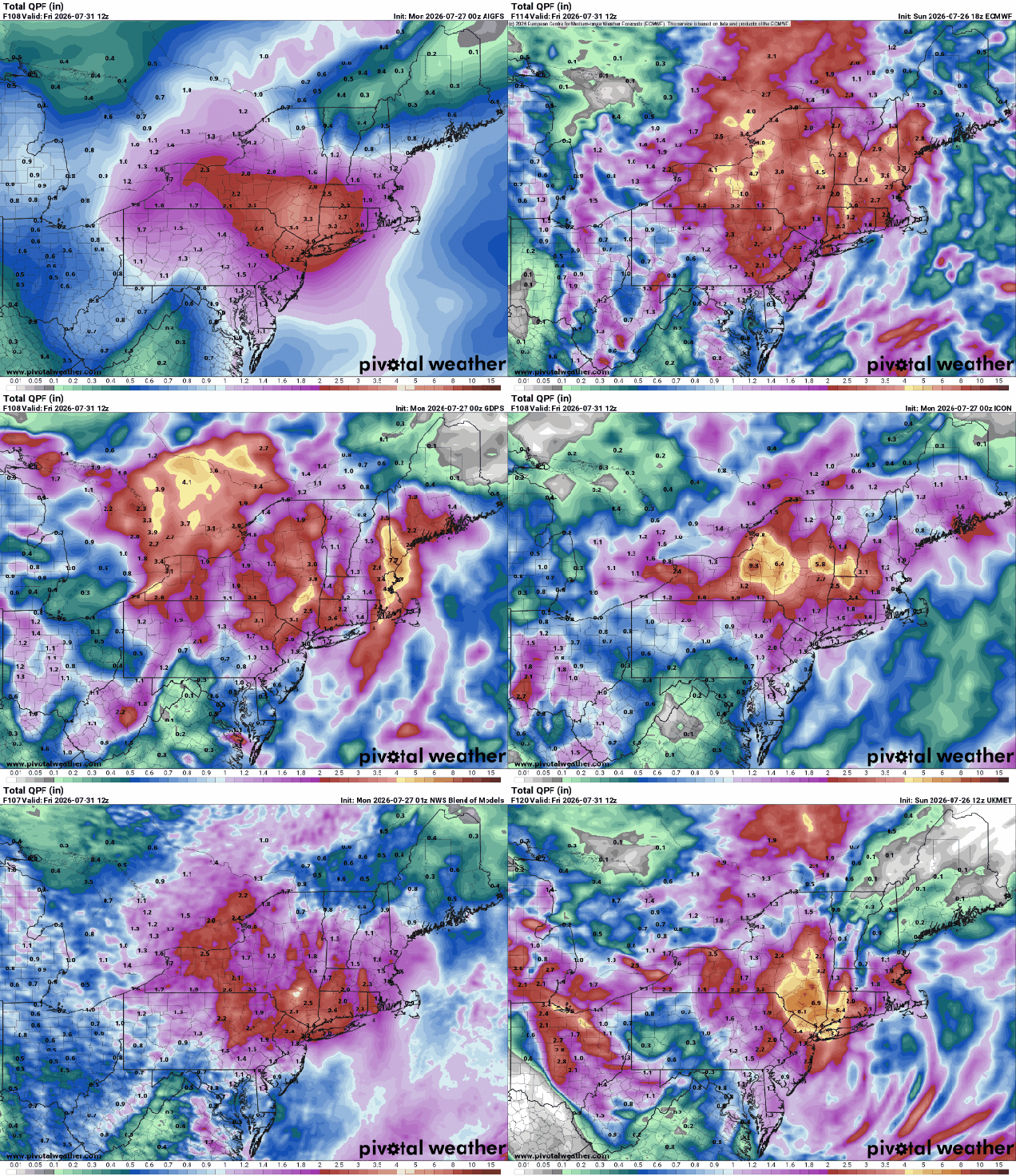
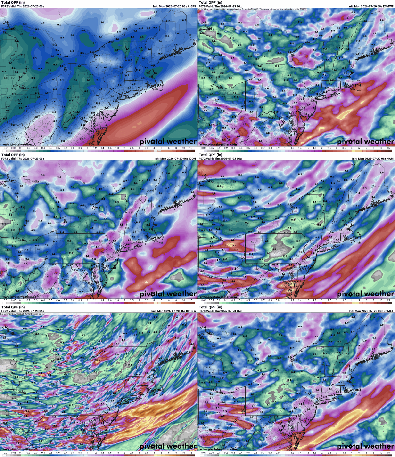
We start the week off with dry and seasonably warm conditions as warm front moves across the region, bring some clouds in. Those clouds will thicken up at night as low pressure heads toward the Great Lakes. Showers and thunderstorms will develop ahead of the system on Tuesday, but as an upper-level low moves into the Midwest, the surface low pressure system will redevelop over the Mid-Atlantic states and head northeastward. The result is a rainy day on Wednesday, possibly quite a bit of rain. Some models show the potential for several inches of rain, resulting in flooding for some areas. The system will be slow to move out on Thursday with more showers likely, ending in the evening. Skies finally start to clear out on Friday the high pressure brings drier and milder air for the weekend.
Many of the models are showing the potential for heavy rainfall later this week. Images provided by Pivotal Weather.
Monday: Sunshine fades behind increasing high clouds. High 79-86, cooler near the coast.
Monday night: Becoming partly to mostly cloudy. Low 59-66.
Tuesday: Partly to mostly cloudy and breezy with showers and thunderstorms developing. High 77-84.
Tuesday night: Scattered showers. Low 60-67.
Wednesday: Breezy with rain likely. High 69-76.
Wednesday night: Rain tapers off to showers. Low 59-66.
Thursday: Cloudy and breezy with more showers. High 70-77.
In the winter, when you’re thinking about a long summer weekend, this is the weather you are dreaming about.
Below normal temperatures are expected through the weekend. Image provided by WeatherBell.
High pressure in the Great Lakes will slide eastward over the next few days. The result will be sunshine, low humidity, and mild temperatures for Friday, Saturday, and Sunday as well. There could be a little haze from wildfire smoke at times, but nothing like what we had a couple of weeks ago. By Monday, the next system will begin approaching. We’ll see some clouds start to move in, with a chance for showers and thunderstorms late in the day as a warm front approaches.
High temperatures are usually in the lower to middle 80s at this time of year. Image provided by weathermodels.com
Thursday night: Clear skies. Low 55-62.
Friday: Sunshine and a few afternoon clouds. High 79-86.
Friday night: Clear to partly cloudy. Low 56-63.
Saturday: Plenty of sunshine. High 77-84.
Saturday night: Partly cloudy. Low 54-61.
Sunday: A mix of sun and clouds. High 76-83.
Sunday night: Clear to partly cloudy. Low 55-62.
Monday: Partly sunny, chance for showers and thunderstorms towards evening. High 79-86.
Much of the upcoming week should feature some rather nice weather.
Temperatures will be near to a little below normal over the next few days. Image provided by weathermodels.com
The week starts off with high pressure in control, keeping the smoke off to our south, and giving us sunshine, seasonably warm temperatures, and low humidity. As the high moves offshore, Tuesday will be similar, though we’ll see temperatures a little warmer, and a few more clouds, especially late in the day. A warm front will be heading our way, with some showers and thunderstorms expected ahead of it late Tuesday night into part of Wednesday. Wednesday should be much more humid as well, with southwest winds behind the front bringing the humidity back in. A cold front will move in late in the day, triggering another round of showers and thunderstorms. Depending on the timing of that front, some of the storms could be rather potent. High pressure then builds in with drier weather for the end of the week and start of the weekend. Humidity levels start to increase again late in the weekend as another front begins heading our way.
Beneficial rain is possible Tuesday into Wednesday, especially south of the Mass Pike. Images provided by Pivotal Weather.
Monday: Sunshine and a few clouds. High 77-84.
Monday night: Clear during the evening, increasing clouds overnight. Low 58-65.
Tuesday: Intervals of clouds and sun, showers and thunderstorms developing in the afternoon, breezy. High 75-82.
Tuesday night: Plenty of clouds with showers and thunderstorms likely. Low 63-70.
Wednesday: Showers and thunderstorms taper off early, becoming partly sunny, breezy, another round of showers and thunderstorms possible late in the day. High 80-87.
Wednesday night: Showers may linger across parts of Cape Cod, gradual clearing elsewhere. Low 58-65.
Thursday: Plenty of sunshine, not as humid. High 74-81.
Some more smoke is in our future, but so is some rain.
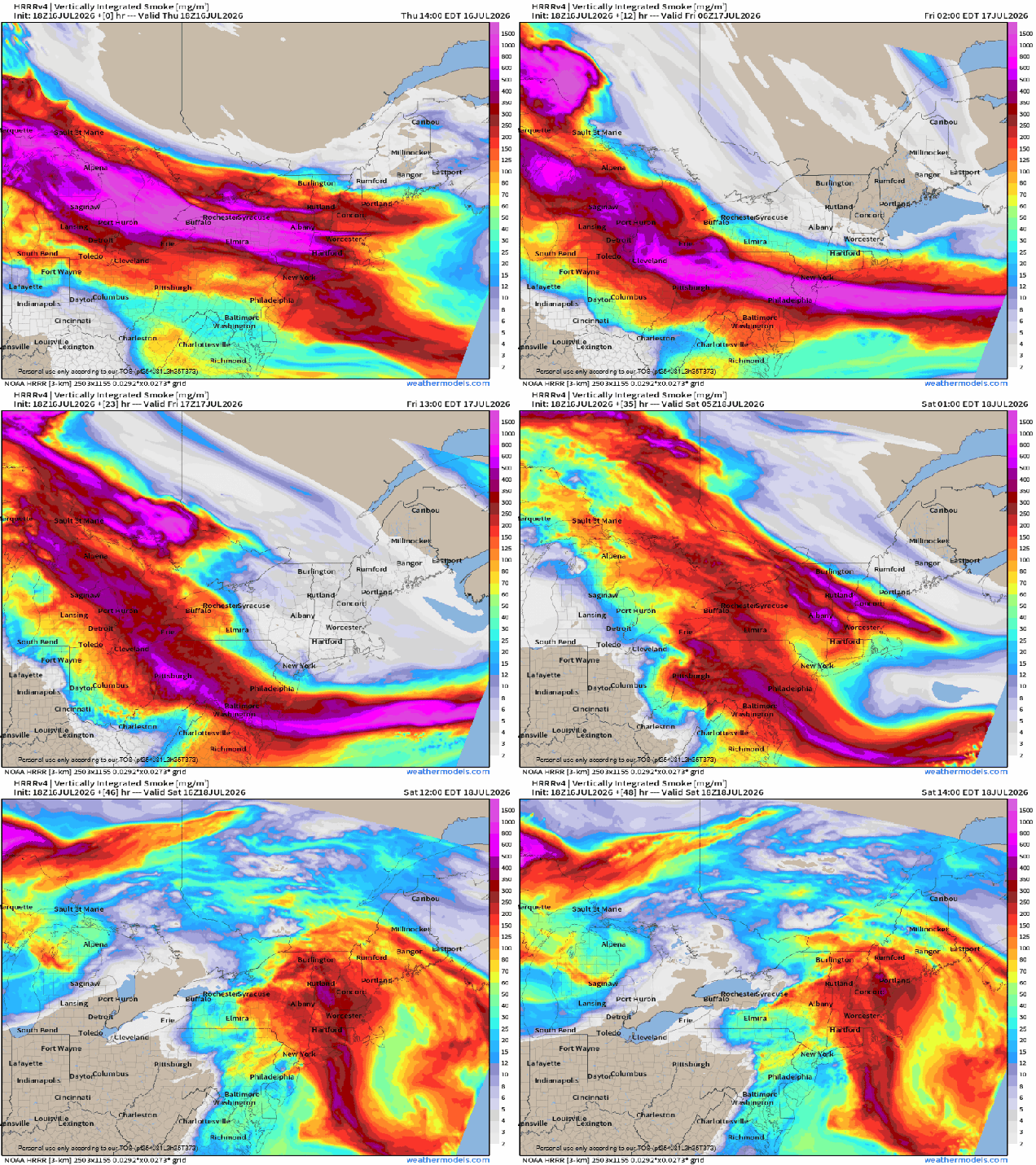
Plumes of smoke will continue to move in over the next few days. Loop provided by weathermodels.com
Another plume of smoke will move through this evening, but a cold front is moving through at the same time. The front will produce a few showers and thunderstorms through the evening, but most of us will remain dry, especially south of the Mass Pike. As the front slides offshore it will take the smoke with it. Friday should be a rather nice day with sunshine, lower humidity, and warm temperatures. Another plume of smoke will start to move in towards evening, but most of the day should be smoke free. After that, low pressure will start heading our way, sending a warm front through. Saturday may start off with some hazy sun, but clouds will quickly move in, with humidity levels also rising. Some showers and thunderstorms are expected late in the day and at night. We need all the rain we can get to help put a dent in the drought, and this will provide some, but we need a lot more and to have it fall with more consistency. We’ll gradually clear out behind the system on Sunday, with cooler and drier air return. High pressure provides us with sunshine and seasonably mild temperatures on Monday, though we need to watch to see if more smoke will head our way.
Some models show the potential for heavy rain across Rhode Island and southeast Massachusetts Saturday, but many don’t. Images provided by Pivotal Weather.
Thursday night: Evening clouds and smoke, showers and thunderstorms ending, then clearing overnight. Low 56-63.
Friday: Plenty of sunshine, some smoke and haze may return towards evening. High 78-85.
Friday night: Clear to partly cloudy, some haze and smoke around. Low 56-63.
Saturday: Some hazy morning sun, then becoming partly to mostly cloudy with showers and thunderstorms developing in the afternoon, breezy. High 82-89.
Saturday night: Cloudy with showers and thunderstorms gradually ending. Low 64-71.
Sunday: Becoming mostly sunny, breezy, less humid. High 78-85.
Sunday night: Clear skies. Low 57-64.
Monday: Partly to mostly sunny, some smoke and haze could return late in the day. High 77-84.
Heat and humidity will return this week, but not to the extent that we experienced recently.
Heat returns to the region on Tuesday. Image provided by weathermodels.com
High pressure slides offshore today, with increasing temperatures and humidity levels. A pop-up shower or thunderstorm can’t be ruled out, but they’ll be few and far between. Tuesday looks even hotter, except along the South Coast and Cape Cod, with southwest winds act as a seabreeze. A cold front moves through early Wednesday with little fanfare, but it will bring some drier air into the region. It will remain hot, and with northwest winds, the heat will get all the way down to the South Coast. Another front moves through on Thursday, possibly producing a shower or thunderstorm, but most places will remain dry, which means we don’t get much drought relief. Cooler air settles in for Friday. The weekend is a bit uncertain at this point. A low pressure system may move out of the Great Lakes and towards New England with some showers and thunderstorms at some point, but the timing, and whether the system even materializes, is still a question.
A system may bring in some rain late Saturday. Images provided by Pivotal Weather.
Monday: Sunshine and some afternoon clouds, slight chance for a shower or thunderstorm, breezy. High 82-89, cooler across the South Coast and Cape Cod.
Monday night: Clear to partly cloudy. Low 64-71.
Tuesday: A mix of sun and clouds, breezy, humid. High 90-97, cooler across the South Coast and Cape Cod.
Tuesday night: Clear to partly cloudy, muggy. Low 73-80.
Wednesday: Partly to mostly sunny, breezy, not as humid. High 88-95.
Wednesday night: Clear skies. Low 64-71.
Thursday: A mix of sun and clouds, slight chance for a shower or thunderstorm, breezy. High 84-91.
Thursday night: Clear skies. Low 61-68.
Friday: Mostly sunny. High 80-87.
Saturday: Partly sunny, showers and thunderstorms possible late in the day. High 78-85.
Sunday: Partly sunny, chance for some showers and thunderstorms. High 77-84.
Hot and humid weather will make a brief return, but most of the weekend looks rather nice.
It will feel like it is in the 90s across most of the region Thursday afternoon. Image provided by WeatherBell.
High pressure sitting offshore has brought high humidity back to the region along with very warm to hot conditions, but it won’t last too long. A cold front will cross the region on Friday, with showers and thunderstorms ahead of it during the afternoon and evening. We’re not expecting widespread severe weather but some of the storms could produce heavy rainfall and gusty winds. The front pushes offshore Friday night, though it could linger near the South Coast for a while, keeping some clouds and possibly a few showers into early Saturday, otherwise, high pressure builds back in with lower humidity and seasonable warm conditions for the rest of the weekend and Monday.
Dewpoints will drop into the 50s behind the front on Saturday. Image provided by Weathermodels.com
Thursday night: Any showers end this evening, partly to mostly cloudy with patchy fog overnight. Low 66-73.
Friday: A mix of sun and clouds, showers and thunderstorms develop in the afternoon. High 82-89.
Friday night: Showers and thunderstorms taper off and end, becoming partly cloudy across southern New Hampshire and northern Massachusetts. Low 63-70.
Saturday: Becoming partly to mostly sunny, less humid. High 77-84, a little cooler across Cape Cod.
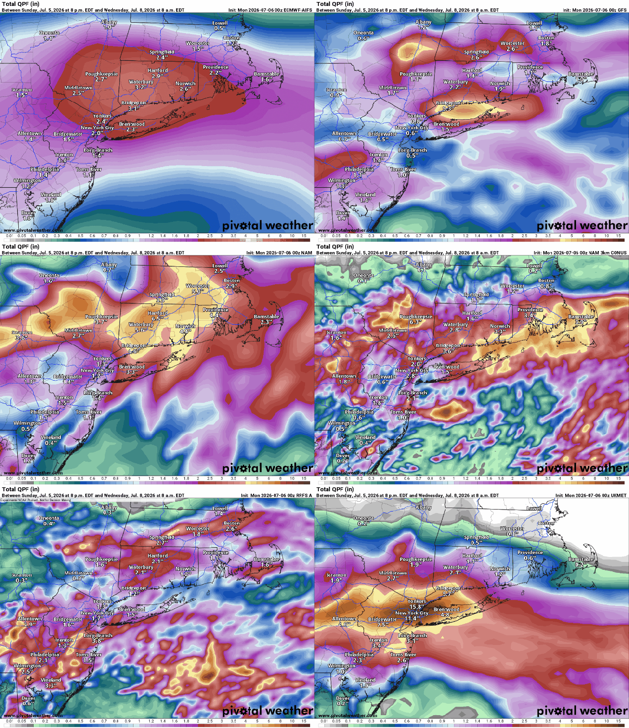
You’ve heard us use the phrase “When in drought, leave it out” in relation to rainfall plenty of times. There is a corollary to that phrase – “Droughts end in floods”, which we’re going to use for the next few days.
Excessive rainfall is likely today into early Tuesday. Images provided by the Iowa Environmental Mesonet at Iowa State University.
The front that brought an end to the heat Saturday night has stalled out south of New England, and a wave of low pressure will ride along it over the next day or so. This will result in periods of rain, some of it heavy at times later today into a good chunk of Tuesday, mainly south of the Mass Pike. Many of the forecast models are showing the potential for 2-4 inches of rain, with amounts in excess of 6 inches possible. Pinpointing where these tropical downpours will be the heaviest is a fool’s errand, but that much rain in a short period of time, even with the ongoing drought, will result in areas of flooding. That’s why Flood Watches have been issues for much of Rhode Island and southeastern Massachusetts, as this is where the heaviest rain is expected. The question is, how much rain falls north of the Mass Pike? While there are some models that bring the heavy rain all the way into southern New Hampshire, many of them have the amounts taper off quickly north of the Pike, with little rainfall once you get into southern New Hampshire. With the cloudcover and rainfall, temperatures will be quite cool, with many places staying in the 60s, especially on Tuesday, The showers wind down Tuesday night, then high pressure builds in with gradually improving conditions on Wednesday, though temperatures will remain below normal. Very warm weather returns for Thursday as high pressure moves offshore, with some places getting back to 90. This heat will be short-lived, as another cold front moves through on Friday with some showers and thunderstorms. High pressure brings cooler and drier weather in for Saturday, with temperatures turning a bit warmer again on Sunday.
Many of the models are forecasting some very heavy rainfall, especially south of the Mass Pike. Images provided by Pivotal Weather.
Monday: Cloudy with periods of rain and showers, mostly south of the Mass Pike. High 69-76.
Monday night: Rain likely, heavy at times south of the Mass Pike. Low 57-64.
Tuesday: Rain during the morning, tapering off to showers in the afternoon. High 64-71.
Tuesday night: Showers ending during the evening, some clearing may start late at night, mainly north and west of Boston. Low 55-62.
Wednesday: Becoming partly to mostly sunny. High 75-82, a little cooler near the coast.
Wednesday night: Clear to partly cloudy. Low 61-68.
Thursday: Sunshine and some afternoon clouds. High 85-92, cooler near the South Coast and Cape Cod.
Thursday night: Partly cloudy. Low 65-72.
Friday: Partly sunny with some showers and thunderstorms likely in the afternoon. High 83-90.
As we get ready to celebrate America’s 250th, some very hot weather will be here for a few days.
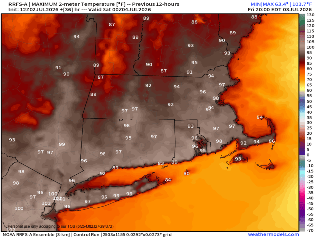
Friday will be another hot day before relief starts moving in on Saturday. Image provided by weathermodels.com
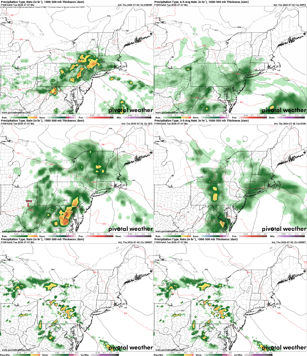
A ridge of high pressure continues to provide the eastern half of the nation with hot and humid conditions into Saturday. Daytime temperatures well into the 90s, combined with dewpoints in the 60s and lower 70s, will make it feel like 100-105 at times. Not much relief comes at night, with lows only in the 70s tonight through Friday night, with places like downtown Boston possibly not falling below 80. A few widely scattered showers and thunderstorms are possible tonight, but they’ll be a bit more numerous Friday afternoon and evening. The Fourth of July is the transition day, and unfortunately, with plenty of outdoor gatherings planned, they could be impacted. A cold front will drop southward, but ahead of it, we’re going to have another hot and humid day, with most places topping 90 again. However, the front will trigger some showers and thunderstorms, especially during the afternoon. Some of these storms may produce heavy downpours and gusty winds, so keep an eye to the sky (or the radar) if you’ll be outside. Hopefully the storms will end before evening, allowing many fireworks celebrations to proceed. Welcome relief arrives on Sunday with cooler and drier air. Cool is a relative term, and most places will still be in the 80s, which is right around or a little above normal. Monday is the day with the most uncertainty at this point. That front will stall out south of New England, and as we get to Monday a wave of low pressure will ride along it. Some models bring in some showers with the wave during the afternoon, some wait until nighttime. We’re going to be cautiously optimistic that most if the day remains dry at this point, but that is far from guaranteed.
Will the rain arrive Monday afternoon or wait until nightfall? Images provided by Pivotal Weather.
Thursday night: Mostly clear, slight chance for a shower or thunderstorm during the evening. Low 72-79.
Friday: Sunshine and a few clouds, a late-day shower or thunderstorm is possible. High 93-100, cooler across Cape Cod.
Friday night: Partly cloudy, chance for a few showers or thunderstorms, mainly before midnight. Low 72-79.
Fourth of July: A mix of sun and clouds, scattered showers and thunderstorms develop, mainly in the afternoon. High 89-96.
Saturday night: Any showers or storms end in the evening, clear to partly cloudy overnight. Low 65-72.
Sunday: Partly sunny, not as humid. High 81-88, cooler near the coast.
Sunday night: Partly cloudy. Low 60-67.
Monday: Intervals of clouds and sun, chance for showers late in the day. High 72-79.