El Nino has resulted in in a quiet start to hurricane season in the Atlantic, but things may be changing.
Several areas of interest are being monitored in the Atlantic and the Pacific. Image provided by PolarWx.
Atlantic Hurricane Season usually (but not always) features below normal activity in the Atlantic Ocean. The main reason for this is high-level wind shear, and that has been the case so far this season, especially across the Caribbean. In the tropics, trade winds resulting in most systems moving from east to west. Wind shear is when you have strong winds in the upper levels of the atmosphere blowing from west to east. As thunderstorms intensity, the strong winds in the upper levels essentially rip the tops off of them, so they cannot fully develop, and thus systems can’t get organized.
Wind shear across the tropical Atlantic is the second strongest on record this season. Image provided by Colorado State University.
The other issue that has caused a relative dearth of storms in the Atlantic has been Saharan Dust. Every year, strong winds blow plumes of dust and sand from the Sahara across the Atlantic and towards the Caribbean and the Gulf. These plumes contain very dry air, inhibiting the development of showers and thunderstorms, and produce very hazy conditions across the islands of the Caribbean. Normally these plumes begin to wane in intensity by mid-to-late July, but this year they have remained fairly strong into early August. Another fairly strong plume will move across the Greater Antilles over the next few days.
Plumes of Saharan dust continue to cross the Atlantic. Loop provided by weathermodels.com
Most forecasts, including the most recent update from the team at Colorado State University, continue to show the likelihood of a below-normal season. Thus far, there have only been two named storms in the Atlantic – both in the Gulf. Short-lived Tropical Storm Arthur along the Texas coast in mid-June, and Tropical Storm Bertha, which brough gusty winds and heavy rain from the Florida Panhandle to Louisiana in mid-July. On average, we should have had three named systems by now, with the third one forming around August 3, and the fourth named system of the season forming around August 15 on average. The first hurricane of the season forms around August 11 on average. In terms of Accumulated Cyclone Energy or ACE, which factors storm strength and duration, activity in the Atlantic is only about 22% of normal thus far.
Forecasts continue to show the likelihood of a below normal hurricane season in the Atlantic. Image provided by Colorado State University.
Tropical waves continue to roll off of the west coast of Africa every few days, and as they move into the Atlantic they encounter the Saharan dust and accompanying dry air, the strong wind shear, and water temperatures in the eastern Atlantic that aren’t warm enough to support a tropical system, but that may be changing. Water temperatures in the tropical Atlantic are now warm enough all the way to the coast of Africa to support a system. The last few waves that have moved into the Atlantic have been a bit more robust, with more widespread shower and thunderstorm activity. Forecast models are showing two areas that need to be watched in the Atlantic over the next week for development.
There are two disturbances that need to be monitored for development in the Atlantic over the next week. Image provided by the National Hurricane Center.
A tropical wave that moved off the west coast of Africa early Friday is now southwest of the Cabo Verde Islands and producing disorganized showers and thunderstorms. Conditions right now are marginally favorable for the system to get organized as it crosses the Atlantic. By the time it reaches the Lesser Antilles, wind shear will increase and conditions will quickly become hostile, eliminating any chance of further development. Another cluster of thunderstorms is moving off the west coast of Africa this evening, but it is farther north than most of the tropical waves, and will likely get choked off by Saharan dust fairly quickly.
Tropical waves continue to move across the Atlantic. Loop provided by Tropical Tidbits.
Another wave will move off of the west coast of Africa early next week. This wave is expected to be fairly robust, and will likely encounter a less hostile atmosphere as it moves into the Atlantic. Several forecast models have been indicating the possibility that this system could develop into at least a tropical depression, and possibly fairly quickly once it is over water. Of course, this is still days away, and until there is an actual storm for the models to initialize, it is all just speculation. It’s something we’ll continue to monitor for the next several days.
Many members of the ECMWF Ensemble show the potential for a tropical cyclone over the Atlantic next week. Loop provided by weathermodels.com
The Atlantic isn’t the only basin where things are getting active. There are three separate systems being monitored for development in the Eastern Pacific, once of which has a slight chance of impacting Hawaii later next week. In the Western Pacific, Typhoon Dolphin will make landfall in eastern China a few hundred miles south of Shanghai on Sunday. Tropical Storm Chan-Hom is expected to make landfall in Japan more than 100 miles north of Tokyo on Tuesday. Tropical Depression Kujira should become a tropical storm and pass a few hundred miles north of the Northern Marianna Islands late Sunday, and another system is expected to develop well northeast of the Northern Mariannas by early next week.
Atlantic hurricane season officially starts on Monday June 1 and runs through November 30, and most forecasts are showing the potential for a less active season, thanks to a developing El Nino in the Pacific.
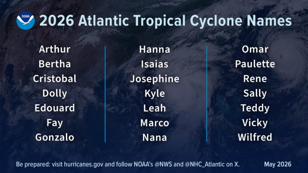
List of names for storms that form during the 2026 Hurricane Season. Image provided by NOAA.
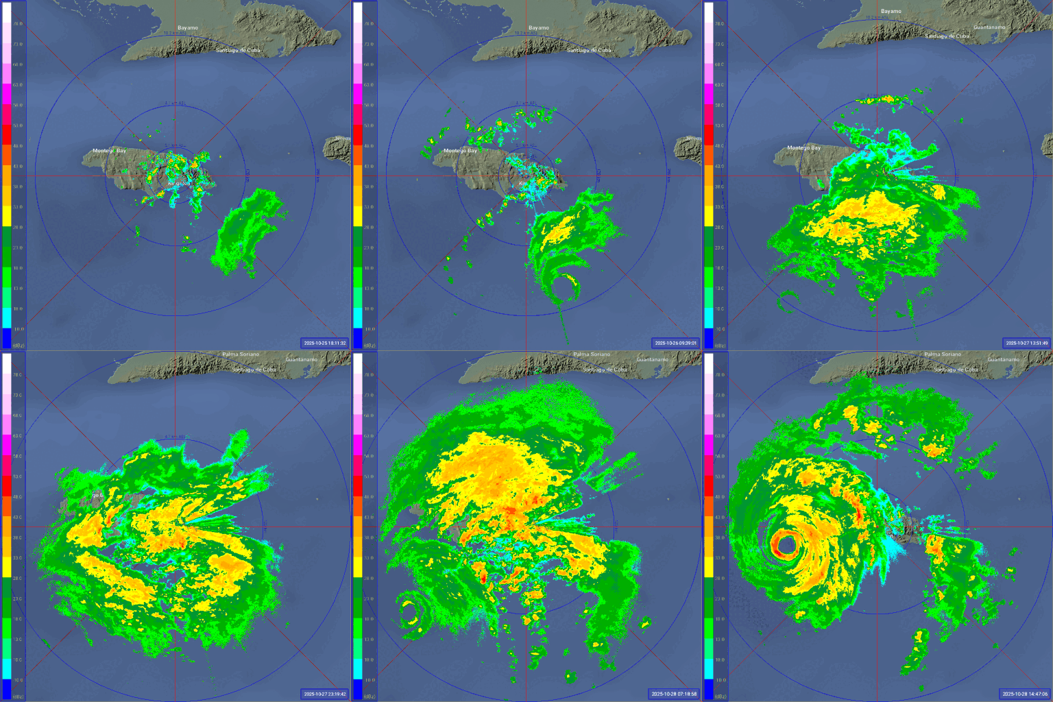
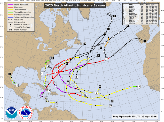
The 2025 season was a near normal season by the numbers, with 13 named storms, 5 hurricanes, and 4 major hurricanes. The season got off to a slower start than recent years, with only 3 storms through the end of July, and 6 through late August. The normal peak of hurricane season is late August and the first 3 weeks of September, but 2025 featured a complete absence of activity during that period. After Tropical Storm Fernand dissipate on August 27, there were no storms at all until Tropical Storm Gabrielle formed on September 17. That was the first of 7 named storms over the next 6 weeks, but once Hurricane Melissa dissipated on Halloween, there were no additional storms for the rest of the season. Hurricane Melissa was not only the strongest storm of the season, it was one of the strongest ever recorded in the basin. While stalling out south of Jamaica it rapidly strengthened into a Category 5 storm with maximum sustained winds near 190 mph, and a central pressure of 892mb not long before slamming into western Jamaica. The sustained winds of 190 are tied with 2019’s Hurricane Dorian, and the 1935 Labor Day Hurricane for the strongest on record in the Atlantic basin. The lowest central pressure of 892mb is tied with the 1935 Labor Day storm for the 3rd lowest on record in the Atlantic, trailing only the 882mb reading in 2005’s Hurricane Wilma, and the 888mb reading in 1988’s Hurricane Gilbert. It also is tied with the 1935 Labor Day storm for the lowest pressure on record at landfall. After the season was over, the name Melissa was retired and removed from the 6-year list of storm names. It will be replaced by Molly in 2031. Melissa is the 100th storm name to be retired in the Atlantic.
Radar loop showing Hurricane Melissa approaching Jamaica. Loop provided by Brian McNoldy, Univ. of Miami, Rosenstiel School.
Only one storm made landfall in the US in 2025 – Tropical Storm Chantal, which had maximum sustained winds of 50 mph when its center moved ashore near Myrtle Beach, South Carolina early on July 6. The one landfall is a welcome change from recent years that featured multiple storms making landfall in the US, many of them as hurricanes. In 2021, a total of 8 tropical systems made landfall in the United States, but only 2 at hurricane strength. That includes 2 tropical storms that made landfall in New England that summer – Elsa and Henri. Both Elsa and Henri each made landfall near Westerly, Rhode Island about 6 weeks apart. This was just the 5th time since 1851 that two tropical systems made landfall in Southern New England or Long Island in the same year, and only the 2nd time (1961 being the other), that both storms were only tropical storm strength. (We’ll have more info on New England tropical systems a little later in this post).
2025 was a less active hurricane season than previous years. Image provided by the National Hurricane Center.
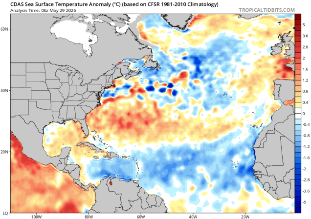
Forecasts for the upcoming season are calling for a season that features below normal activity, due to a developing El Nino in the Pacific Ocean. In fact, there are many forecasts out there calling for a very strong El Nino. In general, where there is an El Nino present, activity in the Atlantic is suppressed, due mainly to increasing wind shear. However, this is not always the case, as El Nino is just one factor. In 2023, we had a strong El Nino in place for much of the hurricane season, and there were 20 named storms that season, making it the fourth most-active season on record. Of those 20 storms, 7 became hurricanes, and 3 were major hurricanes. Hurricane Idalia slammed into the Florida Big Bend region as a Category 3 storm. Sea surface temperatures in the Atlantic are below normal for a large portion of the basin right now, especially in the Main Development Region, but they are forecast to warm to near to above normal levels, which tends to result in more storms.
Sea surface temperatures are below normal right now across much of the Tropical Atlantic and much of the Caribbean. Image provided by Tropical Tidbits.
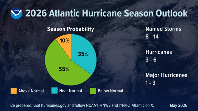
NOAA issued their seasonal hurricane outlook on May 21, and it calls for a 55 percent chance for a below normal season, a 35 percent chance for a near normal season, and just a 10 percent chance for an above normal season. Most of the other hurricane outlooks issued by various outlets are also expecting a near to below normal season, due to the signals mentioned above. An average season consists of 14.4 named storms, of which 7.2 become hurricanes and 3.2 become major hurricanes (Category 3 or higher on the Saffir-Simpson scale). NOAA’s forecast for this season calls for 8-14 named storms, 3-6 hurricanes, and 1-3 major hurricanes. The Tropical Meteorology Project at Colorado State, the first group to forecast how active a hurricane season would be, originally led by the late Dr. Bill Gray, will issue their updated forecast on June 10. Their initial forecast from April called for a below average season, with 13 named storms, 6 hurricanes, and 2 major hurricanes. They also pegged the chance at a storm making landfall in the Massachusetts at 24% (33% is the average in any given year), and the odds of a hurricane making landfall in Massachusetts at 10% (14% is the average). Overall, 8 of the past 10 hurricane seasons have featured above normal activity across the Atlantic.
Tropical activity in the Atlantic is expected to be below normal this season. Image provided by NOAA.
Despite the early start for the many of the past several years, the average date for the first named storm in the Atlantic is still June 20, and the average date for the first hurricane is August 11. Over 97% of all named storms in the Atlantic form between June 1 and November 30. Most early season storms tend to be on the weaker side, as water temperatures are cooler, and wind shear is usually a little stronger. A hurricane hasn’t made landfall in the United States before July 1 since Hurricane Bonnie came ashore as a minimal hurricane near the Texas/Louisiana border on June 26, 1986.
Based on climatology, the most likely spots for an early season storm are off the Southeast coast, in the Gulf of Mexico, or the northwestern Caribbean. Image provided by the National Hurricane Center.
The number of storms that form in any given season has no correlation on how many storms (if any) will impact the United States. In 2010, 19 named storms were observed in the Atlantic, 12 of them became hurricanes, and 5 were major hurricanes. Only one storm made landfall in the United States, and that was Bonnie, which was a minimal tropical storm at landfall. In 1990, there were a total 14 named storms, 8 of them hurricanes and 1 major hurricane. Not a single one of them made landfall in the United States. On the flip side, only 7 named storms formed in 1992, and the first one didn’t develop until August 16. That storm, however, was named Andrew, and it made landfall just south of Miami as a category 5 storm. It only takes one storm to ruin your entire year.
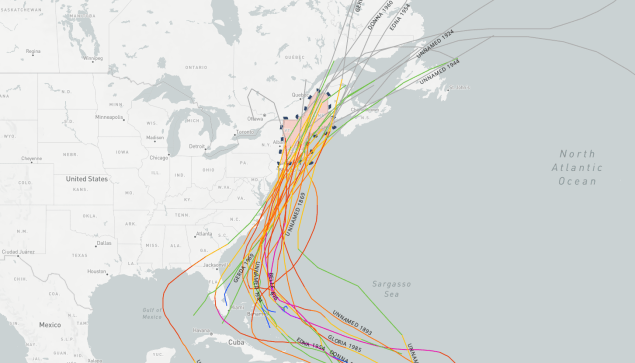
Map showing the track of all of the hurricanes that crossed New England single 1851. Image provided by NOAA.
Here in New England, we should always pay attention when a storm is nearing the Bahamas, as those are the ones that have the potential to impact us, and we are extremely overdue for a hurricane to make landfall. Using the HURDAT database which has data back to 1851, here are some stats that show exactly how overdue we are:
Since 1851, 39 storms of tropical storm strength of greater have made landfall in New England or Long Island, an average of one every 4.5 years. The longest we’ve ever gone without one is 11 years, between 1897 and 1908 and also between 1923 and 1934. In 2021, we had two tropical storms (Elsa and Henri) make landfall in the region, so it’s been 5 years, which means we are due for another.
Since 1851, 32 strong tropical storms (maximum sustained winds of 60 mph or more) have made landfall in New England or Long Island, an average of one every 5.5 years. The longest we’ve ever gone without one is 19 years, between 1897 and 1916. In 2021, we had two strong tropical storms (Elsa and Henri) make landfall in the region.
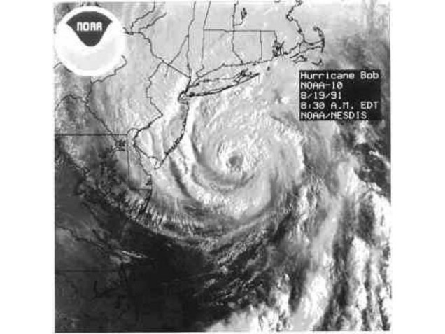
Since 1851, a hurricane has made landfall in New England or Long Island 18 times, an average of one every 9.7 years. The longest we’ve ever gone between hurricane landfalls is 38 years, between 1896 and 1934. It’s now been 35 years since Hurricane Bob, our 2nd longest drought on record.
Since 1851, 8 hurricanes of Category 2 intensity or stronger have made landfall in New England or Long Island, an average of one every 21.9 years. The longest we’ve gone between hits by storms of that intensity is 69 years, between 1869 and 1938. We’re at 35 years since Bob, the last one to do so.
Since 1851, New England/Long Island has had 3 Major Hurricanes (Category 3 or higher) make landfall – an unnamed storm in October of 1869 that grazed the eastern tip of Long Island before making landfall just west of Charlestown, RI; the infamous 1938 Long Island Express that made landfall near Brookhaven, NY and then again near New Haven, CT; and Hurricane Carol in 1954 which crossed East Hampton, NY and then made a 2nd landfall near Groton, CT. That’s an average of 1 every 58.3 years, and we’re now at 71 years since Carol, making this the longest stretch on record. There are also 3 documented storms from before 1851 – The Great Colonial Hurricane of 1635, the 1815 New England Hurricane, and the Norfolk and Long Island Hurricane of 1821. That’s it. That changes the numbers to 6 in 391 years, or one every 65.2 years, with a longest drought of 180 years.
Satellite photo of Hurricane Bob approaching New England. Bob was the last hurricane to make landfall in New England – 35 years ago. Image provided by NOAA.
We all saw what Sandy did back in 2012, and that was a minimal hurricane that eventually made landfall in southern New Jersey (technically as an extratropical storm), though there were other factors that led to the amount of damage it caused. When (not if) the next big storm comes up the coast, much of this region will not be prepared for the storm or its aftermath. A storm doesn’t need to make a direct hit on New England to have significant impacts. In addition to Sandy, the so-called “Perfect Storm” in 1991 was an offshore system that became a hurricane and battered the coastline with strong winds and significant coastal impacts for a few days around Halloween. In 1955, Hurricane Connie and Tropical Storm Diane both made landfall in North Carolina 5 days apart. Connie tracked into the eastern Great Lakes, but still produced some heavy rain in New England, especially western New England. A few days later, Diane passed just south of New England on its way out to sea, but produced widespread rainfall totals of 5-15 inches across most of southern New England, with 19.75″ in Westfield, Massachusetts. The combination of these back-to-back storms resulted in some of the worst flooding this region has ever seen.
Rainfall totals from Tropical Storm Diane in August, 1995. Image provided by NOAA.
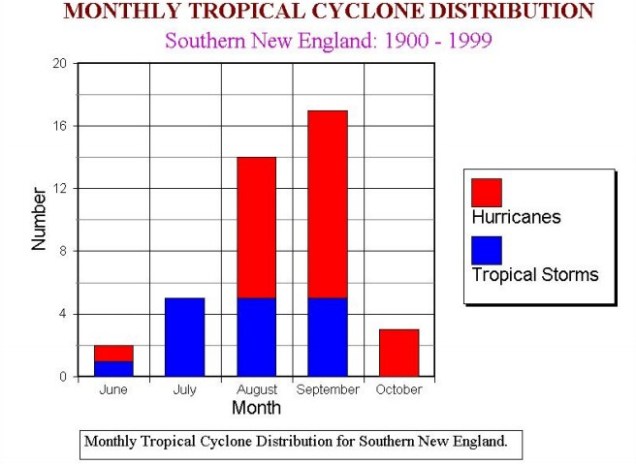
The Atlantic is quiet right now, but even if something were to form off the East Coast in the next few weeks and head this way, the waters off of New England are still much too cold to sustain a tropical system, so we’d see something more like a typical nor’easter. Only two tropical storms have ever made landfall in the Northeast before the end of June. The first was an unnamed minimal tropical storm that crossed extreme eastern Long Island and went into southeastern Connecticut on May 30, 1908. The other was Tropical Storm Agnes, which made landfall near New York City on June 22, 1972, then caused devastating flooding across parts of the Mid-Atlantic states. In terms of hurricanes, the earliest one to ever make landfall up this way was Hurricane Belle, which slammed into Long Island as a minimal hurricane with 75 mph winds on August 9, 1976. We did have Hurricane Arthur pass just offshore of Nantucket on July 4, 2014. While it did not make landfall, it made for a rather wet and cool holiday, especially across Cape Cod and southeastern Massachusetts. Statistically, the most likely time for a hurricane to hit New England is between the middle of August and late September. Of the 18 hurricanes that made landfall in New England or Long Island since 1851, 15 of them have done so between August 19 and September 27.
The most likely time for a tropical system to impact our area is August of September. Image provided by the National Weather Service office in Norton, MA.
As always, you should get your weather information from a trusted source (hopefully you trust us), especially when dealing with tropical systems. Much like with snowstorms in the winter, there will be plenty of hype and exaggeration on Twitter and Facebook, as well as people posting doom and gloom maps showing how a thunderstorm near the coast of Africa will develop into a Category 5 storm and head right for the East Coast in the next 2 weeks. We’re not among that group, we give you facts and our best forecasts, without any hype. If there’s reason to worry, we’ll let you know with plenty of advance warning. It’s always best to prepare ahead of the season. Chances are, you won’t have anything to worry about, but in case you do, it’s always good to be prepared.




 Storm HQ