Time’s Up, Winter is Arriving

We made it through November with just a few flakes, but your luck has run out. Mother Nature has decided to start December with a bang. We’ve got a very complicated storm coming, and for most of us, it’ll include snow, potentially a lot of it.

Winter Storm Watches and Warnings have already been posted for parts of the Northeast. Image provided by Pivotal Weather.

Today is a sunny albeit chilly day thanks to high pressure moving into southeastern Canada. As that high slides into Quebec, our sunny, chilly day will become a clear and cold night. Meanwhile the storm that’s been slamming the Rockies and Plains states for the past few days will head towards the Midwest. Normally, that would be good, as storms heading in that direction will move up the St. Lawrence Valley, keeping us mild with some rain. That’s not the case this time.

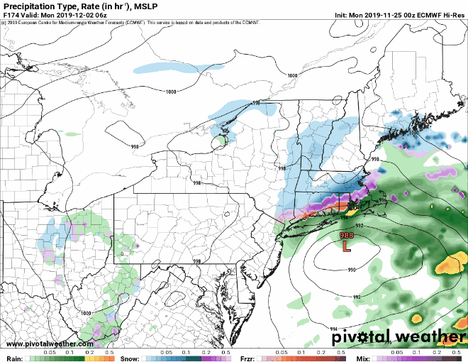
A secondary area of low pressure will develop off the Mid-Atlantic coastline on Sunday, and slowly drift south of Long Island. This will spread snow into the region during the mid/late afternoon hours on Sunday. Snow may fall moderate to heavy at times during the evening and into the first part of the overnight. As warmer air moves in aloft and at the surface, a change to sleet and then rain is expected along the coast, pushing inland as the night moves on. Precipitation should lighten up considerably toward daybreak as the low moves southeast of New England. So, that’s it, right? A quick 12-hour burst of snow and/or slop and we’re all done, right? Nope.

The GFS model shows the progression of the storm over the next few days. Loop provided by Tropical Tidbits.

We’ll have some occasional flurries, drizzle, and freezing drizzle during the day on Monday as the system slowly moves out. At the same time, an upper-level low will move into the Northeast, spawning another system south of Long Island. This will bring colder air back into the region, with another period of steady snow Monday night into Tuesday morning, with everything winding towards daybreak Tuesday.

Now, there are several things that are still in doubt, that could have a significant impact on the forecast. First and foremost – the change to sleet and/or rain Sunday night. How quickly does the changeover happen and how far inland does it get? There’s at least one model that shows the change to sleet happening quickly and as far inland as southern New Hampshire, with a prolonged period of sleet for much of the evening and overnight. This is a detail that we’ll hopefully have a better handle on in the next 12-24 hours. Second problem – the second batch of snow Monday night. This is not set in stone either, and if it does occur, we’re still not sure exactly where that band sets up or how heavy it will be.

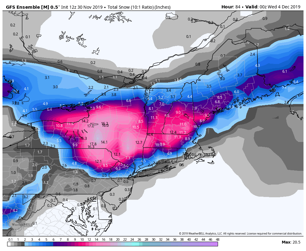
So, having said that, how much do we expect? Keep in mind, this is preliminary, and we will almost certainly update it again before the snow starts Sunday afternoon:

Cape Cod: 1″ or less, mainly with the batch Monday night:
Southeastern MA: 2-4″ (1-2″ Sunday afternoon, another 1-2″ Monday night)
I-95 corridor (Boston/Providence): 3-5″ (1-3″ Sunday afternoon/evening, 1-2″ Monday night)
North Shore/MetroWest: 4-7″ (3-5″ Sunday afternoon/night, 1-2″ Monday night)
Merrimack Valley: 6-10″ (4-8″ Sunday afternoon/night, 1-2″ Monday night)
Southern NH/NH Seacoast: 8-12″ (6-10″ Sunday afternoon/night, 1-2″ Monday night)
Central NH: 10-15″ (Mostly Sunday night into midday Monday)

The GFS Ensemble Mean is probably closest to our thinking at the moment. Image provided by WeatherBell.

Obviously, we’re staying very conservative with that 2nd batch, and we’re hoping to have better clarity on that with the next few model runs. We’ll update again tomorrow.

Weekly Outlook: November 25 – December 1, 2019

Thanksgiving is upon us, and at least it shouldn’t be as cold as last year. We’ve got a few things to worry about before worrying about leftovers though.

Similar to last week, we’re starting off this week with a bit of an icing problem. Many roads remained wet after yesterday’s rain, and temperatures dropped below freezing this morning, so again, if you’re heading out this morning, be careful as untreated surfaces could be slippery. We will see sunshine though, as high pressure builds into the region. That’ll keep it on cool side today, but as the high slides off to the east, milder weather will settle in for Tuesday.

Tuesday could be a mild day with some sunshine across the region. Image provided by Weathermodels.com

Moving along, Wednesday is a big travel day for many people, and also the last work day of the week for plenty of people as well. Well, it’ll be mild, but also damp. Low pressure will pass north and west of the region, so we’ll be on the warm side of it for a while, but it will drag a cold front through late in the day. That’ll bring an end to the rain, but also usher colder air in for Thanksgiving. It won’t be as cold as last year, but it will still be cool and breezy, so bundle up if you’re heading outside, especially if you’re heading to one of the traditional Thanksgiving high school football games.

Wind chills will be in the upper teens and 20s Thanksgiving night and Friday morning, so bundle up if you’re heading outside. Image provided by WeatherBell

Sunny and cool conditions are expected on Friday as high pressure builds in, so dress warmly if you’re heading out for some Black Friday sales. The dry and cool weather continues into Saturday. Sunday, however, is still a big question mark. Low pressure will move into the Midwest for the weekend, but could impact our area on Sunday. The models don’t agree on the evolution of the system, and as a result, have a wide variety of ideas. At this point, almost anything could happen. We could have snow, sleet, freezing rain, rain, any combination of all of these, or even none of them if the system ends up moving slower than expected. For now, we’ll just say that Sunday looks unsettled, and we should have a better idea of what to expect later in the week.

The European model, Canadian model, and American model have very different ideas about what may happen around here next Sunday. Image provided by Pivotal Weather.

Monday: Sunshine and a few clouds, watch out for black ice in the morning. High 45-52.

Monday night: Clear to partly cloudy. Low 29-36.

Tuesday: Partly to mostly sunny. High 49-56.

Tuesday night: Clear skies. Low 31-38.

Wednesday: Becoming mostly cloudy with showers likely during the afternoon and evening. High 47-54.

Thanksgiving: A mix of sun and clouds, a lingering shower or two are possible across parts of Cape Cod, breezy. High 41-48.

Friday: Mostly sunny. High 34-41.

Saturday: Sunshine gradually fades behind increasing clouds. High 34-41.

Sunday: Mostly cloudy with a chance of…….something. High 38-45.

Weekly Outlook: November 18-24, 2019

Ice in your drink? That’s a good thing. Ice on an injury? It helps, so it’s good too. Ice on the roadways? Not good at all. Unfortunately, some of you may have to deal with that this morning.

Winter Weather Advisories are in effect this morning for much of the Northeast. Image provided by Pivotal Weather.

The low pressure system that brought heavy rain, strong winds, and coastal flooding to the Carolinas over the weekend will pass south and east of New England today, bring some of those same issues here, but also introducing other problems. It will bring in some rainfall to our area today, with some strong winds, especially across Cape Cod and southeastern Massachusetts. Some coastal flooding is possible across eastern Massachusetts around high tide as well. However, the biggest problem will already be ongoing (or maybe even over) by the time most of you read this.

Some light precipitation will move into the region this morning ahead of the system. Temperatures will also be below freezing, mainly north and west of Interstate 95. What happens when you have subfreezing temperatures at the surface, warmer air aloft, and some precipitation falling? If you guessed freezing rain and/or freezing drizzle, then you are correct! That’s bad news if you’ve got to be out and about on the roads this morning. Most cities and towns should have pre-treated the roads, but some of the side roads and also bridges and overpasses could be a little slick this morning, so use caution and give yourself a little extra time. Temperatures should warm above freezing most places this morning before the steadier and heavier rain arrives, so there shouldn’t be too many problems.

We’re not expecting much freezing drizzle/rain this morning, but it doesn’t take much to make roads icy. Image provided by WeatherBell.

After a miserable day today (temperatures in the 30s, gusty winds, and rain – you have a better word to describe it?), the system pulls away tonight, but one last batch of precipitation moves through overnight and early Tuesday as an upper-level low pressure area moves across the Northeast. This will be mostly rain, but as some colder air starts to move in behind the storm, some wet snowflakes could mix in, especially across the higher terrain from central Massachusetts into southern New Hampshire.

The WRF model shows temperatures below freezing across the interior through mid-morning and highs only in the 30s today. Loop provided by Weathermodels.com

Once the system pulls away, we dry out on Tuesday, but the clouds remain in place into Wednesday as another system passes offshore. This one will be too far offshore to produce anything more than clouds, but it will help to bring colder air down from the north. High pressure builds in for Wednesday night and Thursday with clearing and chilly weather.

Clouds come back late Thursday as low pressure heads toward southeastern Canada. That low passes by to the north and west on Friday, dragging a cold front across the region. It will get mild ahead of the front, but some more rain is expected as well. Once the front moves through, high pressure builds back in for Saturday with another shot of cold weather. Sunday is still up in the air a bit. We’ve got one model showing a weak system passing by to the north, with a few snow showers, while another model has a system moving in from the southwest, with some rain, and a third model has high pressure building in.

Temperatures on Friday might actually be a little above normal. Image provided by WeatherBell.

If you’re looking ahead to Thanksgiving already, well, it’s too early to try and pin down any specifics, but most of the models have a fairly potent storm system moving out of the Midwest and towards the Northeast sometime in the Wednesday/Thursday timeframe. For now at least, the models are showing mostly rain, but again, it’s a long ways away. If you’re traveling for the holiday, just keep an eye on the forecast. We’ll have more details in next week’s outlook obviously.

A storm system could impact Thanksgiving travel or the eastern half of the nation. We’ll keep an eye on this over the next week plus. Loop provided by Tropical Tidbits.

Monday: Cloudy and breezy (windy across Cape Cod) with some freezing drizzle north and west of I=95 in the morning, changing to plain rain by midday. Occasional showers becoming a steady rain during the afternoon south and east of I-95. High 33-40 north and west of Boston, 40-47 south of Boston.

Monday night: Cloudy with some showers likely. Low 32-39.

Tuesday: Mostly cloudy with showers ending in the morning, possibly mixed with some wet snow over the higher terrain. High 40-47.

Tuesday night: Partly to mostly cloudy. Low 27-34.

Wednesday: Plenty of clouds. High 38-45.

Thursday: That big bright thing in the sky returns, though some high clouds move in late in the day. High 41-48.

Friday: Mostly cloudy and milder with some showers likely. High 49-56.

Saturday: Becoming partly to mostly sunny and colder. High 38-45.

Sunday: Clouds return again with a chance for some showers. High 40-47.

Weekly Outlook: November 11-17, 2019

Thank you to all that have served or continue to serve our nation. Image provided by the United States Army

Are you ready? Ready for Winter? It’s coming, and quickly. Better enjoy today, because after that, it’s going to get cold.

We start the week off with high pressure in control, but we’ll have plenty of clouds as a cold front begins to approach the region. That front will move through on Tuesday, with some rain likely ahead of it. Low pressure will develop along this front and move right across the region on Tuesday. Ahead of the low and the front, it will be somewhat mild, but once the front moves through in the afternoon, that’s when things start to happen.

NAM model forecast showing rain coming in ahead of the cold front, changing to snow before ending behind it. Loop provided by Tropical Tidbits.

Colder air comes surging in behind the front, and temperatures will quickly drop Tuesday afternoon. Rain will likely change over to sleet and snow from northwest to southeast. Now we’re not talking about a lot of snow, probably an inch or less in most spots, and mainly on grassy surfaces, but snow will be the least of the concerns. Gusty winds will help to dry out the roads, and ground temperatures remain fairly mild, but with temperatures dropping into the 20s by late Tuesday, we could see some ice developing, especially on elevated surfaces like bridges and overpasses. So, if you’re going to be out and about Tuesday evening or night, use caution.

While there might be a pretty good snowstorm up north, around here, we’re not expecting much. Image provided by Pivotal Weather.

We’ve covered the snow potential, and the potential for slick roads, but here’s the biggest issue we’ll be dealing with – it’s going to be cold. When we say “cold”, we mean “COLD”. As in, record low temperatures Wednesday morning across most of the region. As in wind chills (another phrase most of you don’t like) in the single numbers (Fahrenheit, not Celsius). Yeah, it’s going to feel like January Tuesday night into Wednesday. Oh yeah, we forgot to mention that Wednesday may see highs in the 20s to lower 30s.

Any location that is circled is likely to set a record low temperatures Wednesday morning. Yeah, it’s going to be cold. Image provided by Weathermodels.com

Winds will diminish for Thursday, but it will remain chilly. Temperatures should start to moderate a little on Friday as high pressure slides offshore. Of course, another cold front comes through Friday night and then we get cold again next weekend, but probably not quite as cold as Tuesday night and Wednesday. Temperatures will still be well below normal.

Wind chills will be in the single numbers when most of you wake up Wednesday morning. Image provided by WeatherBell.

Monday: Mostly cloudy with a few showers possible, mainly north of the Mass Pike. High 41-48 north and west of Boston, 49-56 south of Boston.

Monday night: Cloudy with showers developing late at night. Evening low 34-41 north and west of Boston, 42-49 south of Boston. Temperatures may rise after midnight

Tuesday: Cloudy and breezy with showers likely, changing to sleet and snow during the afternoon. Morning high 42-49 north and west of Boston, 50-57 south of Boston, then temperatures quickly drop in the afternoon.

GFS forecast for temperatures starting at midnight tonight and ending at 7am Wednesday. Loop provided by WeatherBell.

Tuesday night: Any lingering snow showers end in the evening, then clearing, breezy, and colder. Low 13-20.

Wednesday: Sunny, breezy, and cold. High 25-32.

Thursday: Intervals of clouds and sun, a few flurries are possible at night. High 34-41.

Friday: Sunshine to start, then clouds move in during the afternoon. High 43-50.

Saturday: Sunshine and some afternoon clouds. High 31-38.

Sunday: A mix of sun and clouds. High 37-44.

Weekly Outlook: November 4-10, 2019

Uh-oh. It’s that time. You’ve been dreading it, but you knew it was coming eventually. We’re going to use a four-letter word that you hate. That’s right, the word is “snow”. It is November after all, and your luck will run out eventually.

On average, our first measurable snow occurs in late October or early November across the region. Image provided by NOAA.

We’ll start the week under the influence of high pressure, so another dry and cool day is expected today. A weak cold front moves through on Tuesday, producing some showers, but they shouldn’t be too heavy or last that long. Ahead of the front, it actually might be a bit mild around here. Don’t get too used to it, because high pressure returns for Wednesday with dry and cool weather once again. This brings us to the end of the week.

Another cold front will move through on Thursday, with some rain likely. The front will likely stall out, but where it stalls is still a big question mark. It’s an important one too, as a wave of low pressure will likely ride along the front. One model has the front stall out well to the south, with the wave staying well offshore. This would allow high pressure to build in, and result in a dry but very cold Friday, and into the weekend. Other models have the front stall just south of the region, and the wave pass a lot closer. This would likely result widespread precipitation across the region, with at least some of it falling as snow across the interior, possibly even to the coastline. High pressure would then build in behind the storm for a dry and very chilly weekend.

The ECMWF model is not painting a pretty picture for Thursday night and Friday. We’ll be paying close attention to it and other models this week. Loop provided by Pivotal Weather.

There’s still plenty of uncertainty with this storm, and at this point, we’re not sure which way to lean. On one hand, some of the models have been indicating for quite some time now the possibility of snow for parts of the area somewhere in the November 9-13 time frame. However, they’ve been changing with the details on nearly every run, so while our confidence has growing that we’d some “some” snow during that period, we really couldn’t go into deeper detail than that. At this point, we still can’t, because there is still little agreement with the models. However, should we end up dealing with a storm system, the closer you are to the coast, the less likely you’ll see accumulating snow. Ocean temperatures are still in the upper 40s to lower 50s, so a wind blowing off the ocean would bring milder air in along the coast. Plus, the ground is still relatively mild. Sure, we could see some snow even at the coastline, but the better chance for accumulating snow would be north and west of Boston. The farther inland, the better the odds. Obviously, we’ll keep an eye on the evolution of this system as the week goes on, and if needed, will write a special blog post later in the week.

Saturday looks like it is going to be quite chilly across the Northeast, no matter what happens before then. Time to pull out the winter clothes. Image provided by WeatherBell.

Monday: Partly to mostly sunny. High 46-53.

Monday night: Partly cloudy. Low 38-45.

Tuesday: Some morning sunshine, then becoming cloudy with a few showers likely during the afternoon. High 54-61.

Tuesday night: Any lingering showers end during the evening, then skies become mostly clear. Low 32-39.

Wednesday: Plenty of sunshine. High 44-51.

Thursday: Some early sun, then becoming cloudy with showers developing late in the day. Showers may change to snow overnight, especially north and west of Boston. High 47-54.

Friday: Cloudy and breezy with a chance of snow north and west of Boston in the morning, chance of rain possibly mixed with wet snow from Boston southward. Skies will clear out late in the day. High 34-41.

Saturday: Mostly sunny. High 32-39.

Sunday: A mix of sun and clouds, breezy. High 41-48.

One final note – several models show the potential for another system towards the middle of next week that may also contain the “s” word. Welcome to winter!