Weekly Outlook: April 30-May 6, 2018

Here at StormHQ, we love the 80s. The music, the movies, everything. We can’t get enough of it. If you love the 80s, then you’re going to love this week’s forecast.

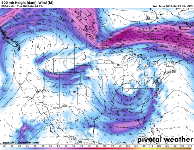
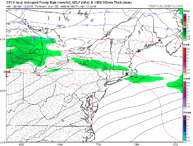
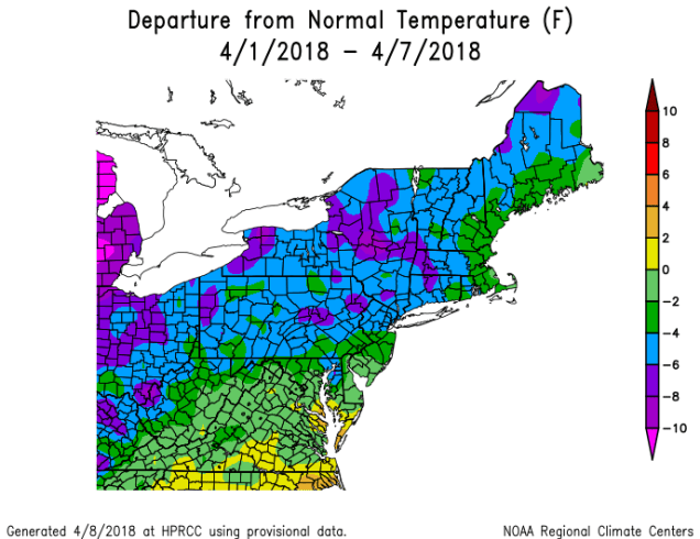
The week starts off on a rather “blah” note. An upper-level low pressure system will move across the Northeast today, giving us clouds, occasional showers, and cool temperatures. In other words, the same weather that we’ve had for the most part for the past 6 weeks. But, after that, things are going to change – for the better.

NAM-WRF 3-km New England Snowfall 24
Yes, the airmass across the Northeast today is cold enough for some snow across the higher elevations of eastern New York and western New England. Image provided by Weathermodels.com

The upper-level low pressure system pulls away on Tuesday, and high pressure starts to build in at the surface. That means we’ll have some sunshine develop, and temperatures will turn milder. This brings us to Wednesday.

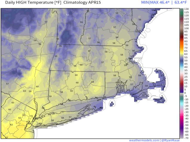
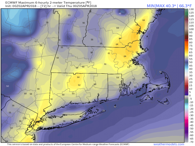
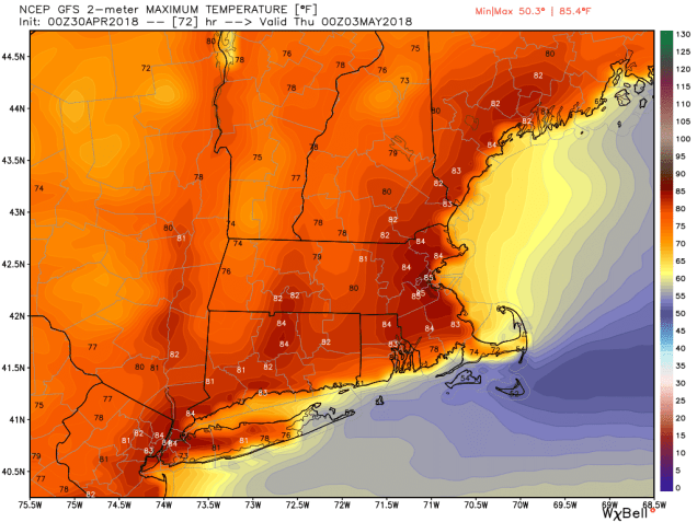
Remember back in the winter, when you were dressed in several layers, had an IV of hot chocolate, and had to go out and shovel your driveway again? Yeah, that sucked, didn’t it? Remember what you were dreaming about then? Well, that arrives on Wednesday. With high pressure in control we’ll have sunshine, low humidity and with gusty southwest winds, temperatures should get into the upper 70s and 80s away from the South Coast and Cape Cod. Yes, we’re serious, and don’t call us Shirley. Thursday will be nearly as good as Wednesday. We’ll have a few more clouds, and a slight chance for some afternoon showers and thunderstorms, but temperatures should again reach the upper 70s and 80s away from the South Coast.

Friday is when things start to transition again. Oh, it’ll still be warm, but we’ll have plenty of clouds as a cold front starts to approach from the west. That front will trigger some showers and thunderstorms during the afternoon and evening hours. Behind the front, skies will slowly clear out on Saturday, but it should remain on the warm side, with temperatures still getting into the 70s in many spots. High pressure builds in on Sunday, with sunshine returning, along with more seasonable temperatures. That means we’ll have highs in the 60s. That might be tough to take after a few days of 70s and 80s, but it’s certainly better than the 40s we dealt with a few weeks ago.

gfs_t2max_boston_13 (1)
If you love the 80s, then Wednesday is looking like an absolutely fantastic day across the region, since most of us will get into the 80s. Image provided by WeatherBell.

Monday: Mostly cloudy and cool with some showers likely. High 47-54.

Monday night: Becoming partly cloudy to clear. Low 37-44.

Tuesday: A mix of sun and clouds, milder. High 62-69, coolest along the coast.

Tuesday night: Clear to partly cloudy. Low 50-57.

Wednesday: Partly to mostly sunny, breezy, and warm. High 78-85, cooler right along the South Coast and across Cape Cod.

Thursday: Partly sunny, breezy, chance for some late-day showers and thunderstorms. High 79-86, cooler right along the South Coast and across Cape Cod.

Friday: Partly to mostly cloudy and breezy with a chance of afternoon showers and thunderstorms. High 74-81.

Saturday: Becoming partly to mostly sunny. High 68-75.

Sunday: Partly sunny. High 62-69.


Weekly Outlook: April 23-29, 2018

Who’s ready for some spring weather finally? OK, so the answer is “everyone”. Guess what? It’s here! Oh, the week won’t be all sunshine and warm temperatures, but some spring better is better than none, right?

We start the week out with high pressure bringing sunshine and warm temperatures to the region today. Tuesday will also be warm, but the sunshine will disappear as clouds start to stream in ahead of a low pressure system moving towards the region. This brings us to Wednesday. It’ll be a cool and damp day, but hey, that’s better than snow, right?

500wh.conus
It’s only temporary (today into Tuesday), but that stubborn upper-level trough of low pressure that’s kept us cool for so long will be replaced by an upper-level ridge of high pressure. Image provided by Pivotal Weather.

The system pulls away on Thursday and skies clear out again, with temperatures getting back close to normal for late April. Friday starts off nice, but another system sends more clouds in, with showers returning late in the day and at night. Again, would you rather have snow? We didn’t think so.

That system pulls away quickly, setting us up for a “meh” weekend. Not great, not bad, just “meh”. With an upper-level trough of low pressure moving in aloft, and high pressure at the surface, it should be mostly dry, but we’ll still have plenty of clouds popping up, with a shower or two possible, but nothing widespread or heavy. Temperatures will be back below normal, but below normal in late April is a lot better than below normal in late February.

ndfd_t2max_climo_massachusetts_3
Normal high temperatures in late April are within a degree or two of 60. Image provided by WeatherBell.

Monday: To quote the great Harris K. Telemacher: “”I’ll have a half double decaffeinated half-caf, with a twist of lemon”. No wait, that’s not the right quote. What we meant was: “Sun! Sun! Sun! Sun! Sun!” High 57-64, coolest right along the coast.

Monday night: Clear skies in the evening, high clouds start to filter in late at night. Low 35-42.

Tuesday: Clouds thicken up during the day. High 60-67, cooler along the South Coast.

Tuesday night: Cloudy with showers developing. Low 42-49.

Wednesday: Cloudy and breezy with occasional showers. High 50-57.

Thursday: A few lingering showers early, then becoming partly to mostly sunny. High 57-64.

Friday: Some early sun, then clouds come back in the afternoon. Showers likely at night. High 60-67.

Saturday: A mix of sun and clouds. High 58-65, coolest along the coast.

Sunday: Partly sunny, slight chance for a shower during the afternoon. High 54-61.

GFS 50-STATES USA Mass & CT & RI 2-m Maximum Temperature 240
At least one model thinks some really mild weather could be heading our way as we flip the calendar to May. Will it happen? Time will tell. Image provided by Weathermodels.com

Weekly Outlook: April 16-22, 2018

Blah. Yuck. Ugh. Take your pick. Any of those words could describe the weather coming up this week. In case you can’t tell, it’s going to suck. In other words, a typical April week in New England.

The week starts off with low pressure heading into the Great Lakes, dragging a cold front towards the region. There may still be some sleet and freezing rain to start the day, especially north and west of Boston, but everything should go over to plain rain during the morning. From late morning through much of the afternoon it’s going rain, sometimes rather heavily. The heavy rain will be accompanied by gusty winds as well. This will make for a rather miserable day for both runners and spectators at the Boston Marathon. The traditional 11am Red Sox game was wisely postponed. This will be the first Patriots Day without a Red Sox game at Fenway since 1995. That year, there was no game because millionaires and billionaires couldn’t figure out how to split billions of dollars, and the millionaires went on strike. The last time the Patriots Day game was postponed due to weather was in 1984.

Orioles42015 002
Patriots Day in 2015 was a pretty cool and damp day, but the Red Sox did manage to get the game against the Orioles in. Maybe they should stop playing the Orioles on Patriots Day.


Temperatures will also be fairly tricky on Monday. Warmer air is going to try to push in from the south, but how far north it gets is a big question mark. Some models bring the milder air as far south as southern New Hampshire, some don’t get it past the Mass Pike. Where the warm air does move in, temperatures should get into the 50s, maybe even the lower 60s. Where it doesn’t, they’ll stay in the 40s, perhaps even the upper 30s.

hires_t2max_boston_25
How far north will the milder air get on Monday? We’re thinking probably not past Route 2, similar to the High Resolution NAM is showing. Image provided by WeatherBell.

The rain ends Monday night, but an upper-level low pressure system settles into the Northeast for Tuesday and Wednesday. This will keep plenty of clouds along with cool conditions in place across the region. A few showers are also possible as well, mainly on Tuesday.

The upper-level low moves out on Thursday, but another surface storm system heads towards the region. That means more widespread showers for Thursday into Friday. This system may take its time pulling away, and cooler air will filter in behind it. Don’t be surprised if we see some wet snowflakes mixed in with the rain on Friday, especially across southern New Hampshire. The showers should end early Saturday, but with another upper-level low moving in, clouds and cool conditions should remain in place. High pressure finally starts to build in on Sunday, with sunshine returning.

9-km ECMWF USA Surface undefined undefined 120
Don’t be surprised if you see some snowflakes on Friday, as the ECMWF model is showing, Image provided by Weathermodels.com

Monday: Any lingering sleet or freezing rain early changing to plain rain. Rain may be heavy at times in the afternoon. Windy. High 42-49 north of Route 2, 50-57 south of Route 2.

Monday night: Partly to mostly cloudy, showers ending in the evening. Low 35-42.

Tuesday: More clouds than sunshine with a few showers possible. High 45-52.

Tuesday night: Becoming partly cloudy. Low 29-36.

Wednesday: Intervals of clouds and sunshine, slight chance for another shower. High 47-54.

Thursday: Mostly cloudy with showers developing. High 45-52.

Friday: Cloudy with more showers, possibly mixing with some wet snow at times, mainly well north and west of Boston. High 43-50.

Saturday: Showers taper off early, otherwise partly to mostly cloudy. High 48-55.

Sunday: Sunshine with some afternoon clouds. High 52-59.


Winter’s Last Gasp?

We’ve reached Patriots Day weekend, which is usually one of the truest signs that winter is over and Spring has finally started in New England. This year that will not be the case. In fact, this year, Patriots Day weekend is going to be absolutely miserable.

t2max_massachusetts_APR15
In mid-April, high temperatures should normally be in the middle to upper 50s around here. Image provided by Weathermodels.com

Don’t let today’s warmth fool you. Even though temperatures are in the 60s and even lower 70s away from the South Coast, big changes are coming, and not for the better. A backdoor cold front will drop down across the region late tonight and early Saturday, bringing much colder air back into the region. Temperatures are going to go slowly down through the 40s all day on Saturday and gusty northeast to east winds are going to make it feel even colder. By Saturday evening, temperatures will drop into the 30s, and they’ll likely stay there through most of Sunday. They may start to drift back up Sunday night and Monday, but it will still be on the chilly side. That’s the least of our problems.

sfct_anom.us_ne
Temperatures on Sunday will be 15 to 25 degrees (or more) below normal. Image provided by Pivotal Weather.

A large storm system is going to bring severe weather to the Mississippi Valley and Gulf Coast today and tomorrow, while producing blizzard conditions in the Plains and Upper Midwest, with a significant ice storm expected in parts of the Great Lakes. That storm is going to slowly make progress eastward over the next few days, with the moisture from it likely arriving late Saturday. As we mentioned earlier, temperatures are going to be dropping into the 30s late on Saturday. If you combine that with incoming moisture, you get a giant mess.

Rain will develop late Saturday afternoon or evening across the region, but as temperatures continue to drop, some sleet will likely mix in, with freezing rain also a possibility, especially north and west of Boston where temperatures could even fall into the upper 20s Saturday night. Sleet and freezing rain will continue across much of the region for a good chunk of the day on Sunday, as temperatures will only rebound into the middle 30s at best for most of the area. The reason we’re expecting sleet (and freezing rain) and not snow, is that the colder air will all be at the lower levels of the atmosphere. It will actually be warmer aloft. We wouldn’t be surprised if the summit of Mount Washington is one of the warmest places in New England Sunday afternoon.

hires_sleet_boston_61
This storm may drop quite a bit of sleet on the region Saturday night into Sunday. Image provided by WeatherBell.

Somewhat milder air will start to filter in Sunday night as low pressure moves into the eastern Great Lakes. This will change everything back over to a cold rain. For once, a cold rain is actually good news, because it means we don’t have to worry about the sleet any more. However, this is bad news as we head into Marathon Monday. As that low heads off to the north and west of the region, it will bring a cold front towards the Northeast. As warmer air surges northward ahead of the front, it will help bring some heavy rain into the area. That warmer air will mainly be aloft, but some of it could reach the surface during the afternoon. In the morning though, when the race starts, and the Red Sox are scheduled to play, we’ll likely have periods of heavy rain, with temperatures only in the upper 30s to middle 40s. Not exactly baseball or running weather. Temperatures could get into the 50s or even low 60s in the afternoon, especially south of Boston, but we’ll still have the heavy rain to deal with. The cold front moves through late in the day, and drier air starts to filter in on Tuesday. Even then, a few showers are still possible as an upper-level low pressure system moves across the Northeast.

gfs_mslp_pcpn_frzn_neus_fh6-120
The GFS forecast is not pretty for the next few days. Stay inside, watch some playoff hockey, and remember that warmer weather is coming eventually. Loop provided by Tropical Tidbits.

So, is this it for winter? We’d like to say yes, but at this point, we can’t make that statement definitively. Longer-range models show below normal temperatures continuing into much of May. While it’s awfully tough to get wintry weather around here at this time of year, it’s not impossible. We have had heavy snow events in late April (1987), and early May (1977). As some of you may remember, in 2013, up to 3 feet of snow fell in parts of Northern New England and Upstate New York during Memorial Day weekend. So, we’d wait until at least mid-May before taking the flip-flops and shorts out of where ever you stored them for the winter.


Weekly Outlook: April 9-15, 2018

Since it seems like winter doesn’t want to end, a question we’ve been asked lately is “when is it going to finally warm up”? If you believe some of the guys on TV or the Facebook Forecasters,  then the answer is “the end of this week.” However, we’re not so sure about that. Not yet, at least.

MonthTDeptNRCC
The first week of April has seen temperatures average several degrees below normal across the Northeast. Image provided by the Northeast Regional Climate Center

We start the week off with an area of high pressure keeping us dry on Monday. Tuesday will feature plenty of clouds along with some snow or rain showers as a weak system moves across the region. High pressure returns on Wednesday, with dry and cool conditions once again. The end of the week is where things get iffy.

On Thursday, low pressure moving into the Great Lakes will send a warm front towards the region. Some showers are likely ahead of this warm front, meaning Thursday will be a gray and possibly damp day. If the warm front does come through, and that’s far from certain right now, a cold front will move through at night as that low pressure system passes north of the region. That cold front will likely stall out south of New England. This leads to our next problem. Does it head northward again as a warm front?

14-km EPS Global KNZW SOUTH WEYMOUTH 15-day Daily Temperature
How uncertain is the late-week warmth? Using this chart which is based on the ECMWF Ensemble forecast for South Weymouth, MA, the high temperature on Saturday could be anywhere from 41 to 76, with a mean of 62. Sunday is nearly as bad with a range of 38 to 70 with as mean of 57. Image provided by Weathermodels.com

Another storm system will move into the Midwest towards the end of the week. Some of the models are trying to have that system lift the front northward again, bringing very mild air into the region later Friday into Saturday. This is certainly possible. However, we’ll have plenty of cold air in place to the north, plus some very cold water off to our east. If you’ve lived here long enough, you know that warm weather doesn’t last too long around here, especially in April. Adding to our doubts is the fact that the models have the storm pass north and west of Chicago. A noted colleague once pointed out to us that with storms passing north and west of Chicago, warm fronts have plenty of trouble making northward progress around here, as they become too far removed from the main system, and lose the push that they need to head northward. This is more obvious in the winter, but since we’re still in a winter-type pattern, we’re taking note of that observation.

Finally, we get to Sunday. This is where things REALLY get complicated. If our warm front comes through, it’ll likely start heading southward again later Saturday as colder air tries to push back in. This could set us up for a VERY chilly Sunday. At the time this forecast was written early Monday morning, one model kept temperatures in the middle 30s to lower 40s all day Sunday, another kept temperatures in the 40s to lower 50s, while a third model had temperatures in the upper 60s and 70s (see maps below). So, there’s plenty of uncertainty. Meanwhile, another cold front will be approaching from the west, and low pressure will be riding out of the Gulf of Mexico along that front. That means that clouds and a few showers are likely. As the low pressure area gets nearer, we could be in for a period of heavy rain, but the timing of that, as well as the actual cold front, are still big question marks. The heavy rain could move in for Sunday night, it might move in Monday morning, or it might hold off until Monday night. Since next Monday is Patriots Day, this makes a BIG difference. We’ll know more on that later in the week.


Monday: Sunshine dimmed by thickening clouds in the afternoon. High 40-47.

Monday night: Partly to mostly cloudy. Low 27-34.

Tuesday: Mostly cloudy with some rain or snow showers possible. High 41-48.

Tuesday night: Becoming mostly clear. Low 25-32.

Wednesday: Sunshine and some afternoon clouds. High 47-54.

Thursday: Mostly cloudy and breezy with a few showers possible. High 51-58.

Friday: Partly to mostly cloudy, chance for a few showers. High 57-64, cooler along the South Coast.

Saturday: Intervals of clouds and sunshine, breezy, and warm. High 60-67, cooler along the South Coast. Temperatures may drop sharply in the afternoon from southern New Hampshire into eastern Massachusetts.

Sunday: Partly to mostly cloudy and breezy, more showers possible, especially late in the day. High 45-52, possibly milder south of Boston.

Weekly Outlook: April 2-8, 2018

We’ve got a lot of different types of weather coming up this week, starting with some snow today, and that’s not an April Fools joke.

The week actually starts off with some light snow for parts of the area. A storm system will pass south of New England today, with a period of light snow likely during the morning, mainly south of Route 2. This will not be a big deal, as there are several factors working against this system.

  1. It will be fast-moving, with snow moving in around the morning rush hour and ending around midday.
  2. Temperatures will be near or above freezing when most of the precipitation falls.
  3. Since it’s early April,, the sun angle is high enough that it’ll be tough to accumulate on paved surfaces unless it comes down very hard.
  4. Dry air in place at the start will evaporate some of the snow before it hits the ground.

Add up all those factors, and you don’t much snow accumulation. In fact, we’re only expecting 1-2 inches on grassy surfaces, mainly from Boston southward. A few places could pick up 3 inches, but that’s about it. Not a big deal.

snku_acc.us_ne (1)
The GFS snowfall forecast is probably closest to our thinking for today’s snow. Image provided by Pivotal Weather.

Skies clear out during the afternoon, but clouds quickly come back in at night as a warm front starts to approach the region on Tuesday. We’ll have rain moving back in during the afternoon and evening, possibly mixed with a little wet snow in a few spots. The warm front comes through overnight, with temperatures rising after midnight. Wednesday will be a cloudy and mild day, but a cold front will be approaching from the west. This will produce more showers and maybe even a thunderstorm. Temperatures drop quickly behind the front Wednesday evening.

9-km ECMWF USA Surface Mass & CT & RI 2-m Maximum Temperature 72
Wednesday is looking like a mild day before the cold front arrives with showers in the afternoon. Image provided by Weathermodels.com

This brings us to the most important day of the week – Thursday. Why is Thursday the most important day? It’s the Red Sox home opener at Fenway! Last year, the opener was on April 3, against the Pittsburgh Pirates, and it was, partly cloudy, breezy, and 48 degrees at game time. This year, it’ll be partly cloudy and breezy once again, but it’s probably not going be 48 degrees at game time. We’ll probably need to shave about 3 or 4 degrees off of that. If you have tickets, dress like you’re going to a Pats game in November.

Hyannis

Clouds stream back in later in the day as another weak system approaches. This system will bring in some light rain or snow Friday into early Saturday, but again, this will not be a big deal, with little to no accumulation expected. High pressure then builds back in later on Saturday and into Sunday. Having said that, some of the models are showing the potential for a storm system to impact the region on Sunday. We’re not ready to jump on board with this just yet, but it would not be unprecedented. Most of us remember the April Fools Day storm from 1997, but how many people remember the April 6-7, 1982 storm? Temperatures stayed in the teens and 20s during that storm. We also had back-to-back storms April 7-8 and April 9-10 in 1996, which dropped a combined 8-20 inches of snow on the area. If this storm starts looking more likely, we’ll let you know later in the week.

19820406-19820407-3.35
Snowfall totals from the April 6-7, 1982 snowstorm. Image provided by NOAA.

Monday: Light snow likely in the morning, mainly south of Route 2, then some sunshine may return in the afternoon. High 39-46.

Monday night: Partly cloudy in the evening, then becoming cloudy again after midnight. Low 27-34.

Tuesday: Mostly cloudy with showers developing in the afternoon. High 41-48.

Tuesday night: Cloudy and breezy with occasional showers. Low 36-43 in the evening, then temperatures rise after midnight.

Wednesday: Windy and mild with more showers possible, maybe even a rumble of thunder. High 57-64, coolest along the South Coast.

Thursday: Partly to mostly sunny, breezy, and colder. High 39-46.

Friday: Mostly cloudy and breezy with some light rain or snow possible, especially late in the day and at night. High 44-51.

Saturday: Chance of light rain or snow early, then becoming partly sunny. High 37-44.

Sunday: A mix of sun and clouds. High 40-47.