If you like heat and humidity, then the first half of the week is perfect for you. If you don’t, well, the end of the week and the weekend might be better, but certainly not perfect.
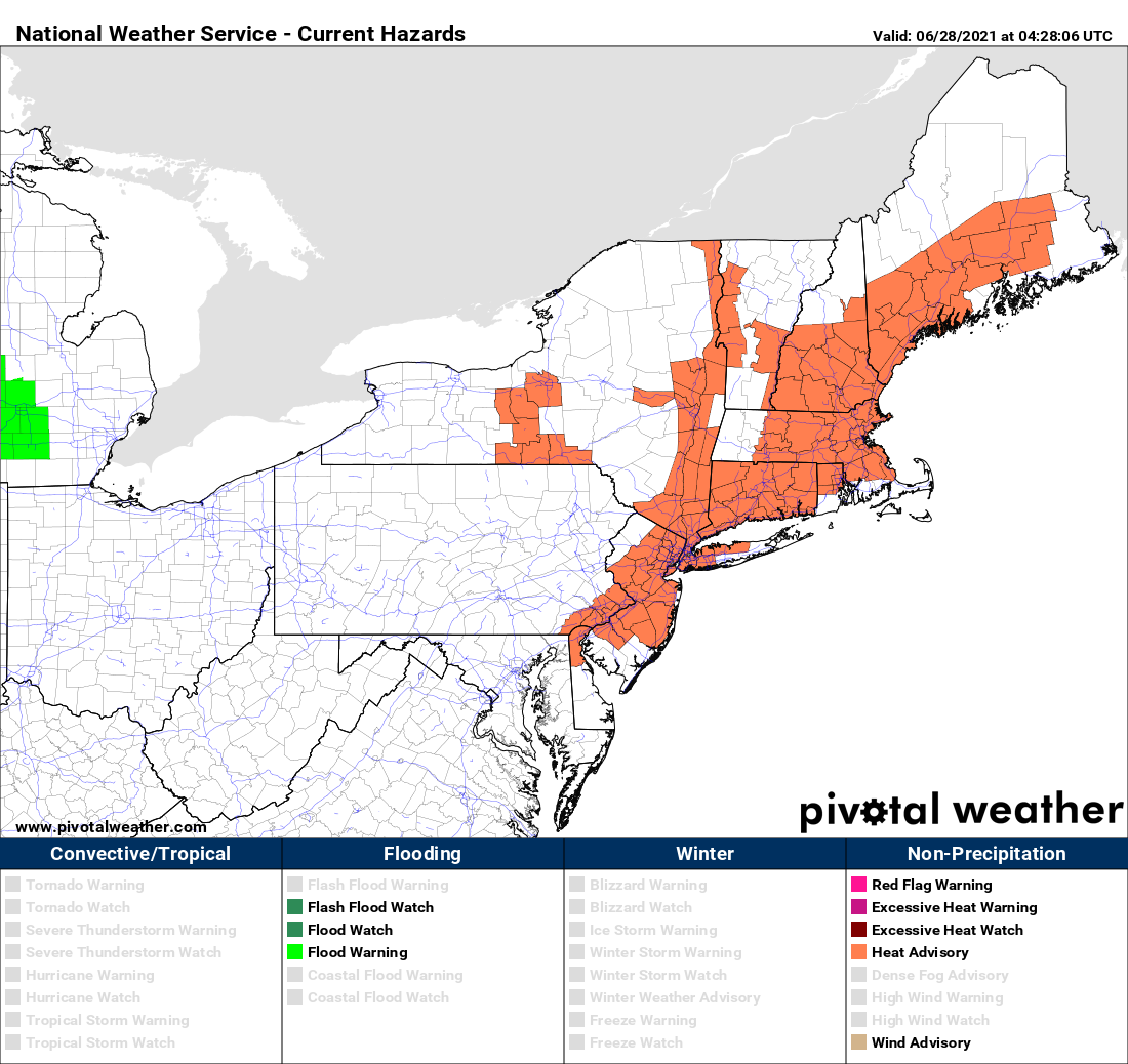
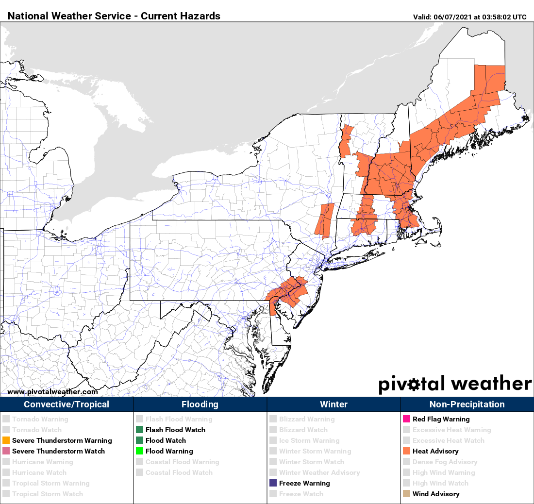
Heat Advisories are in effect for much of the Northeast today. Image provided by Pivotal Weather.
We start the week off with high pressure anchored off the Eastern Seaboard, pumping hot and humid air into the region. Most locations away from the South Coast should get well into the 90s today, tomorrow, and Wednesday. With the humidity factored in, it’s going to feel like it’s near or over 100 degrees. That’s why Heat Advisories have been issued for much of the area. At night, it’ll remain warm and muggy, with lows generally in the 70s. A few showers and thunderstorms may pop up Tuesday and again on Wednesday afternoon, providing a little late-day relief.
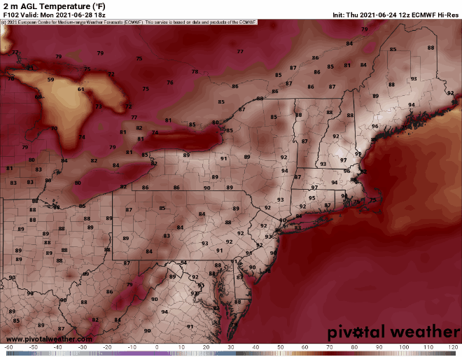
Tuesday looks like the hottest day, but we think the GFS might be overdoing things a little on Wednesday. Image provided by WeatherBell.
A cold front will move in late Wednesday or early Thursday, taking the edge off the heat, but with some more widespread showers and thunderstorms accompanying it. Beyond that, things get a little tricky. That front is expected to wash out near or just south of the region on Thursday. Waves of low pressure will ride along it, with showers and thunderstorms possible at times from Friday into the weekend, but this will also depend on how much southward progress the front makes before it washes out. If it’s far enough to the south, then the shower activity may stay a little farther south. No matter where it stalls, we’re looking at one or possibly two very cool days for the end of the week and start of the weekend. Temperatures should start to moderate again for the Fourth of July.
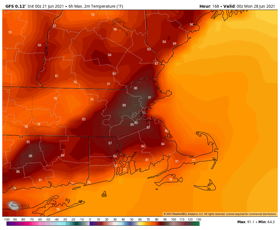
Temperatures on Friday could be 30-40 degrees cooler than Wednesday, if you believe the GFS. Image provided by Weathermodels.com
Monday: Partly sunny, hot, and humid. High 90-97, cooler along the South Coast.
Monday night: Clear to partly cloudy, just a slight chance for a shower or two. Low 70-77.
Tuesday: Sunshine and some afternoon clouds, hot, and humid., a few showers and thunderstorms are possible late in the day. High 91-98, cooler along the South Coast.
Tuesday night: Clear to partly cloudy, any showers or storms end during the evening. Low 69-76.
Wednesday: Partly to mostly sunny, breezy, hot, and humid, showers and thunderstorms are possible during the afternoon and evening. High 89-96 cooler along the South Coast.
Thursday: More clouds than sun with scattered showers and thunderstorms. High 81-88.
Friday: Plenty of clouds and much cooler with more showers possible, especially south of the Mass Pike. High 71-78.
Saturday: Partly to mostly cloudy, chance for showers and thunderstorms. High 68-75.
Fourth of July: More clouds than sun with more showers and thunderstorms possible. High 74-81.
The first full weekend of summer will feature a return of humidity and heat to the region.
A warm front will cross the region late tonight and early Friday. A few showers may accompany the front, maybe even a rumble of thunder, but they should be gone before midday, and they shouldn’t be that heavy either. Skies will start to clear out in the afternoon, and you’ll start to notice the increase in humidity. With the cloud cover likely hanging on through early afternoon, temperatures may not get that warm, especially along the Maine and New Hampshire Seacoast, where the front will take the longest to move through.
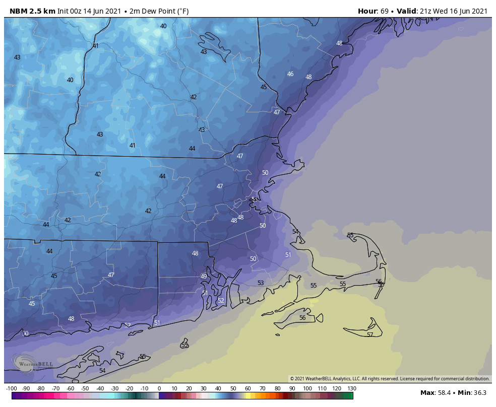
Dewpoints will jump into the middle to upper 60s on Saturday behind the warm front. Image provided by WeatherBell.
The rest of the weekend and Monday will feature typical summertime weather, with sunshine and afternoon clouds, along with a few pop-up showers and thunderstorms. We’ll have a frontal boundary well to our north and west, so we shouldn’t expect any organized severe weather with the front too far away, but any storms that do form could produce some localized downpours and gusty winds. In terms of temperatures, Sunday and Monday look quite toasty, and some models have temperatures getting well into the 90s away from the South Coast. The heat and humidity look to persist into at least the middle of next week.
Monday is looking like it’s going to be hot. Images provided by Pivotal Weather.
Thursday night: Increasing clouds with some showers possible late at night. Low 51-58, but temperatures may start to rise a bit after midnight, especially south of Boston
Friday: Any showers ending in the morning, some partial sunshine develops in the afternoon. High 72-79. Offshore: Southeast to south winds 10-15 knots, seas 2-4 feet.
Friday night: Partly to mostly cloudy. Low 59-66.
Saturday: Partly sunny, slight chance for a shower or thunderstorm. High 80-87. Offshore: South to southwest winds 10-15 knots, seas 2-4 feet.
Saturday night: Partly to mostly cloudy. Low 66-73.
Sunday: A mix of sun and clouds, slight chance for a shower or thunderstorm. High 85-92, cooler along the South Coast. Offshore: Southwest winds 10-20 knots, seas 3-5 feet.
Sunday night: Partly cloudy. Low 67-74.
Monday: Partly sunny, a late-day shower or thunderstorm is possible. High 89-96, cooler along the South Coast. Offshore: Southwest winds 10-20 knots, seas 3-5 feet.
Finally, we’re just going to touch on a couple of other topics. As you may have heard, some incredible heat is expected in the Pacific Northwest this weekend and early next week. Places like Portland, Seattle, and Spokane could shatter all-time records, with temperatures possibly topping 110 degrees. Meanwhile, in the tropics, a rather robust wave has moved off the coast of Africa, and some of the models show the potential for this wave to develop as it crosses the Atlantic. It’s a little early in the season for easterly waves, but we’ll keep an eye on its progress. We plan to write a special blog post on Friday that will cover both of these topics in greater detail.
Now that we’re officially into summer, we’ve got weather that is appropriate for the season.
The week starts off with high pressure moving offshore and a cold front approaching from the west. This will provided the region with hot and humid conditions, but the bulk of the thunderstorm activity should remain to our north and west, though a few showers and storms could make their way into our area. They’ll become a bit more numerous tonight and possibly again on Tuesday as the front gets closer, eventually moving offshore late in the day on Tuesday.
Dewpoints will get into the low 70s across much of the region this afternoon. Image provided by Weathermodels.com
While the front is approaching, “Tropical Storm Claudette” will pass south and east of the region. We’ve criticized the National Thunderstorm Naming Hurricane Center in the past for some of the storms that have gotten names, and this one is no exception. When it was moving through the Gulf at the end of last week, it was a disorganized storm that lacked a well-defined center, but was producing plenty of thunderstorms. Miraculously, it managed to have a center suddenly become well-defined (their definition of “well-defined” is different than many others), right as it was making landfall, so that way, it could be named. Funny how that worked out. Once over land, it quickly weakened (imagine that?) and dropped a ton of rain across the Gulf Coast and the Southeast. Early this morning, while the center was still over the Carolinas, it managed to strengthen again, without a well-defined center (don’t see too many large bodies of warm water in the middle of North Carolina). It should move offshore today, and the forecast calls for it to strengthen over the Gulf Stream again, then become extratropical on Tuesday south of Nova Scotia. OK, enough ranting from us about a storm that will have no impact here other than a little rough surf over the next few days.
Forecast track for “Tropical Storm Claudette”. Image provided by the Canadian Hurricane Centre.
High pressure builds in for Wednesday and Thursday with cooler and drier conditions once again. As the high moves offshore on Friday, humidity levels and temperatures will start to creep up once again, with a few showers possible as a warm front moves through. By Saturday, low pressure will be heading into the Great Lakes, sending another frontal system toward the region. Some showers and thunderstorms are possible, but it looks like we’ll have a better chance at them next Sunday as the front gets closer.
Sunday could be quite warm once again. Image provided by WeatherBell.
Monday: Partly sunny and breezy, just a slight chance for a late-day shower or thunderstorm. High 85-92, cooler along the South Coast.
Monday night: Mostly cloudy, some patchy fog may develop near the South Coast, a few showers and thunderstorms are possible. Low 64-71.
Tuesday: Plenty of clouds with scattered showers and thunderstorms expected. High 78-85.
Tuesday night: Showers ending from northwest to southeast, followed by gradual clearing. Low 50-57.
Wednesday: Plenty of sunshine, perhaps some lingering clouds across Cape Cod. High 71-78.
Thursday: Sunshine and a few clouds. High 75-82.
Friday: Intervals of clouds and sunshine, chance for a few showers. High 75-82.
Saturday: A mix of sun and clouds, breezy, some showers and thunderstorms are possible. High 79-86.
Sunday: Partly sunny and breezy with a chance for more showers and thunderstorms. High 80-87.
Summer officially starts Sunday night, but the last weekend of Spring is looking pretty good for the most part.
Aside from some pop-up cumulus, it’s a picture-perfect day across the region. Loop provided by the College of DuPage.
High pressure remains in control into Friday with more sunshine and warm temperatures as the high slides offshore. Humidity levels may start to creep up a bit on Friday, but it will still be comfortable. Low pressure will be heading into southern Canada later on Friday, and it will send a warm front our way at night. As that front moves through early Saturday morning, it may produce a few showers or thunderstorms. Not a big deal, and they should be done before most of you have finished your breakfast (or even gotten out of bed). Some sunshine may break out in the afternoon, and it will be quite warm and humid. A cold front will sweep across the region during the afternoon and evening. That front will produce another round of showers and thunderstorms. Depending on the timing of the front, some of those storms could become strong to possibly even severe. Don’t go cancelling any late-afternoon or evening plans, but if you’ll be outside, keep an eye to the sky.
High pressure builds back in on Sunday for the final day of Spring (the Summer Solstice occurs at 11:31pm Sunday night) with lower humidity, but it will remain quite warm. Humidity levels and temperatures will creep back up on Monday ahead of the next frontal system. Any shower or thunderstorm activity with this system should hold off until after dark.
We’ll give a quick mention about the tropics here as well. There are no active systems at this time, but there is a cluster of thunderstorms in the western Gulf of Mexico that is being monitored. It will likely become a tropical depression, possibly as early as tonight, then head northward. It should bring some heavy rain to parts of the Gulf Coast and Deep South this weekend. The National Hurricane Center is going to start issuing advisories on “Potential Tropical Cyclone Three” at 5pm EDT. We’ll likely write a blog post about the system either late tonight or tomorrow, once it actually becomes a tropical depression or tropical storm. Beyond that, some of the moisture from this system could interact with the cold front approaching us Monday night, but it’s still a little early to determine if that will happen or not. We’ll have a better idea by the time we issue our Weekly Outlook early Monday morning.
Satellite loop of the Gulf of Mexico where a tropical depression will likely develop tonight or tomorrow. Loop provided by NOAA.
Thursday night: Clear skies. Low 48-55.
Friday: Morning sunshine starts to fade behind increasing late-day clouds. High 77-84. Offshore: Southwest to south winds 10-15 knots, seas 2-4 feet.
Friday night: Mostly cloudy, chance for a few showers or thunderstorms late at night. Low 59-66.
Saturday: A few early showers, then becoming partly sunny. Another round of showers and thunderstorms is possible late in the day. High 80-87. Offshore: Southwest to south winds 10-20 knots, seas 3-6 feet.
Saturday night: Showers and storms end in the evening followed by clearing. Low 58-65.
Sunday: Sunshine and some afternoon clouds. High 81-88. Offshore: Southwest to south winds 10-15 knots, seas 2-4 feet.
Sunday night: Clear during the evening, clouds start to filter in late at night. Low 59-66.
Monday: Partly sunny. High 85-92, cooler along the South Coast. Offshore: South winds 10-15 knots, seas 2-4 feet.
We’re only two weeks into Hurricane Season, and the peak of the season is still three months away, but activity is starting to ramp up in the Atlantic, as another cluster of thunderstorms has received a name.
Satellite loop of Tropical Storm Bill from late Monday afternoon. Loop provided by NOAA.
In our Weekly Outlook early this morning, we mentioned an area of thunderstorms off the North Carolina coast that was disorganized. We also said that given NHC’s history, we fully expected it to be classified as a short-lived tropical depression or storm, even though it really wasn’t one. Well, as expected, the National Thunderstorm Naming Hurricane Center decided that even though there wasn’t much thunderstorm activity along a stationary from Monday morning, it was good enough for them to call it Tropical Depression Two. As of 11pm Monday, it had strengthened into “Tropical Storm Bill”, and was centered about 335 miles east-northeast of Cape Hatteras, NC, moving toward the northeast at 23 mph. Maximum sustained winds were near 45 mph. The system remains weak, and there is not a lot of thunderstorm activity with it at the moment, but it is moving over the warm waters of the Gulf Stream, so there is a small window for the system to intensify over the next 12 hours. After that, it will be moving over colder water, and will weaken before bringing some gusty winds and rainfall to parts of Newfoundland and possibly Nova Scotia tonight and Wednesday.
In the eastern Atlantic, a strong tropical wave has moved off the west coast of Africa, passing south of the Cabo Verde Islands tonight. While this system may develop a little over the next day or two, the combination of unfavorable upper-level winds and dry air will limit any development once the system reaches the central Atlantic Ocean. Once we get a little deeper into hurricane season, conditions should become more favorable as more and more waves roll off of Africa and cross the Atlantic. Some of these storms historically have become powerful systems, as they have plenty of time to develop over open water. We usually need to start paying attention to this region once we get into July.
Saharan dust crossing the Atlantic will limit any storm development. Loop provided by Weathermodels.com
The system that bears watching is in the Bay of Campeche. A cluster of showers and thunderstorms continues to meander around associated with a broad area of low pressure. While this will produce some heavy rain across parts of Mexico and Central America, it is not expected to develop over the next few days. By late in the week however, the system will start drifting northward, and conditions will become more favorable for development. It could become a tropical depression by the weekend, then it may head toward Louisiana or Texas.
Satellite loop of the Gulf of Mexico, including the Bay of Campeche. Loop provided by NOAA.
While it’s still a little early to speculate on any potential track or strength for this system, most of the models are in agreement that most of the rain from this system will head towards Louisiana. Much of southern Louisiana and Mississippi has received 30 to 45 inches of rain over the past 90 days, which is more than twice the normal amount they receive in that time frame. This has led to widespread flooding in areas still attempting to recover from several direct hits during the 2020 hurricane season. A tropical system, even a weak one, could drop 10 or more inches of rain on this area, leading to even more flooding.
Much of the Lower Mississippi Valley has been deluged with more than 30 inches of rain over the past 90 days. Image provided by WeatherBell.
Elsewhere, the only other active system in the tropics is Tropical Depression Carlos in the Eastern Pacific, but it is expected to dissipate on Tuesday over open water.
We’ve got a typical summertime pattern shaping up for the final week of astronomical spring. Astronomical Summer begins with the Summer Solstice on Sunday June 20, at 11:31pm.
The sun angle is the highest in the Northern Hemisphere on the Summer Solstice. Image provided by the Old Farmers Almanac.
The week will actually start off on a damp note as a cold front approaches the region. This will produce scattered showers and thunderstorms, some of which could produce locally heavy rainfall. The entire day shouldn’t be a washout, as these will be more of the hit-and-miss variety, especially late in the day and tonight. Another round of showers and thunderstorms is expected on Tuesday as the front finally moves through the region. Again, some of these could be heavy in spots.
Parts of the region could pick up a decent amount of rainfall between today and tomorrow. Images provided by Pivotal Weather.
High pressure builds in for Wednesday and Thursday with drier and seasonably warm conditions. An upper-level low pressure area will be in place across the Northeast, helping generate some clouds each day, with a slight chance for a pop-up shower each afternoon, but these will be few and far between. By Friday, that high will slide offshore, allowing warmer and more humid air to start to move back into the area. That warm and humid airmass will be in place on Saturday when another cold front approaches, triggering another round of showers and thunderstorms. High pressure returns next Sunday with drier air.
Dewpoints will drop into the 40s and lower 50s by Wednesday afternoon. Image provided by WeatherBell,
Monday: Plenty of clouds with a few showers and thunderstorms, especially early and again late in the day. High 66-73.
Monday night: Mostly cloudy with more showers around. Low 56-63.
Tuesday: Intervals of clouds and sunshine with occasional showers and thunderstorms. High 72-79.
Tuesday night: Becoming clear to partly cloudy. Low 54-61.
Wednesday: Sunshine and some afternoon clouds. High 71-78.
Thursday: Partly to mostly sunny. High 71-78.
Friday: Sunshine fades behind increasing afternoon clouds. High 75-82.
Saturday: Intervals of clouds and sun with scattered showers and thunderstorms. High 78-85.
Sunday: A mix of sun and clouds. High 76-83.
The Atlantic is showing signs of life as we head into mid-June. Image provided by the National Hurricane Center.
Finally, we’re going to mention the tropics. There are two areas that the National Hurricane Center is keeping an eye on in the Atlantic right now. The first one is in the Bay of Campeche. This system will bring heavy rain to parts of Mexico and Central America for the next few days. After that, it should start to drift northward and could get organized. Several forecast models have been showing this potential for a while now. While it’s still too early to tell if anything will actually develop, most of the models are showing a weak system tracking toward either Texas or Louisiana. The more concerning part is that most of the models show the potential for very heavy rain later this week and this weekend, especially in Louisiana. It’s been a VERY wet spring across this area, and additional heavy rain will result in significant flooding. Parts of Louisiana have received 30 to 40 or more inches of rain over the past 90 days, and some models are showing the potential for another 5-10 inches or more next weekend.
The GFS is forecasting a lot of rain at the end of the week for an area that doesn’t need it. Image provided by WeatherBell
The other area being watched is a cluster of thunderstorms off the Carolina coastline. It’s disorganized and non-tropical right now, but will be moving over the warm waters of the Gulf Stream today and tomorrow. Given NHC’s recent history, we fully expect it to be named a short-lived Tropical Depression or Storm (even though it won’t actually be one) before it moves over colder water east of New England and south of Nova Scotia on Wednesday.
The heat and humidity are gone, and won’t be back for a while, but that doesn’t mean the weather will be perfect this weekend.
The first 9 days of June have averaged 4-8 degrees above normal across the region. Image provided by the Northeast Regional Climate Center.
High pressure settles in for Friday with dry and cool conditions. A weak frontal system will drop southward Friday night, possibly producing a few showers across the region late Friday night or early Saturday morning. High pressure builds back in for Saturday afternoon and evening with sunshine returning. It will remain cool, with easterly winds keeping locations right along the coast in the 60s. We’ll start to warm up again on Sunday, but another system approaches the region with some showers and possibly thunderstorms later Sunday and Sunday night. As that system slows down, another round of showers and thunderstorms is possible on Monday.
Thursday night: Clear to partly cloudy. Low 47-54.
Friday: Becoming partly to mostly cloudy. High 67-74. Offshore: Northwest winds 10-15 knots, seas 2-3 feet, unlimited visibility.
Friday night: Mostly cloudy, chance for a few showers, mainly in southern New Hampshire and northern Massachusetts. Low 51-58.
Saturday: Showers end early, then becoming partly sunny. High 69-76. Offshore: Northeast winds 10-15 knots becoming southeast 5-10 knots, seas 2-4 feet, visibility 1-3 miles early, improving in the afternoon.
Saturday night: Plenty of clouds. Low 52-59.
Sunday: A mix of sun and clouds, chance for some late-day showers. High 75-82. Offshore: Southwest to south winds 10-15 knots, seas 2-4 feet. Visibility lowering to 1-3 miles in late-day showers.
Sunday night: Mostly cloudy with scattered showers and thunderstorms. Low 55-62.
Monday: Intervals of clouds and sun, showers and thunderstorms possible, especially late in the day. High 71-78. Offshore: South winds 10-15 knots, seas 3-5 feet. Sunday: A mix of sun and clouds, chance for some late-day showers. Offshore: Southwest to south winds 10-15 knots, seas 2-4 feet. Visibility lowering to 1-3 miles in late-day showers.
The heat is definitely on, and will remain on for a few more days.
Heat Advisories are in effect for parts of the Northeast today. Image provided by Pivotal Weather.
High pressure remains anchored offshore, with southwesterly winds pumping hot and humid air into the region for the next few days. Today should be the hottest of the days, but humidity levels will be on the rise for Tuesday and Wednesday. A few widely scattered showers are possible this afternoon and evening, but the most of the activity should stay west of us. We’ll have a better chance at showers and thunderstorms developing on Tuesday, but Wednesday looks like the best chance overall as a cold front approaches the region. When that cold front moves through will have a large impact on the temperatures across the area. Right now, it looks like the front holds off until Wednesday night, so another very warm to hot and humid day is expected, but an earlier arrival would result in a much cooler afternoon, especially along the coast.
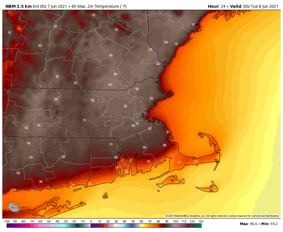
Away from the South Coast it’s going to be quite toasty today. Image provided by WeatherBell.
High pressure builds in for Thursday with much drier and cooler conditions. Beyond that, things get a little uncertain. That front likely stalls out just south of the region, but how far south is yet to be determined. Waves of low pressure may ride along the front, with some showers accompanying these waves, but again, if the front stalls out too far to the south, these waves will have little to no impact here. Some models show the potential for Friday to be quite chilly and wet. We’re not so sure that’ll be the case, but we’re not completely ruling it out yet either. By late Saturday or Sunday, another system may approach with another round of showers possible.
At least one model shows another chilly and wet day coming up on Friday. Image provided by Weathermodels.com
Monday: Sunshine and a few afternoon clouds, slight chance for a late-day shower or thunderstorm. High 90-97, cooler along the South Coast.
Monday night: Partly cloudy, slight chance for a shower during the evening. Low 66-73, cooler along the South Coast.
Tuesday: Intervals of clouds and sun, a few widely scattered showers or thunderstorms are possible during the afternoon. High 86-93, cooler along the South Coast.
Tuesday night: Partly to mostly cloudy, chance for a few showers during the evening, some patchy fog may develop along the South Coast. Low 64-71.
Wednesday: Partly sunny, a few showers and thunderstorms possible during the afternoon and evening. High 83-90, cooler along the South Coast.
Thursday: A mix of sun and clouds. High 75-82, cooler along the coast.
Friday: More clouds than sun with some showers possible. High 68-75.
Saturday: Partly sunny. High 68-75.
Sunday: A mix of sun and clouds, chance for a few showers. High 71-78.
The first weekend of meteorological summer is upon us, and it’ll certainly feel like summer around here.
A warm front will move across the region this afternoon, and as an upper-level disturbance swings through tonight, those two will combine to bring in some showers and thunderstorms. While a few of them may produce some heavy rain near the South Coast, most of us shouldn’t see that much rain tonight. Another upper-level disturbance crosses the region on Friday accompanying a dying cold front. This will produce another round of showers and thunderstorms, mainly during the afternoon and evening. A few of these storms could produce downpours and gusty winds.
Last weekend’s rain erased the developing drought for much of southern New England. Image provided by the National Drought Mitigation Center.
Once everything moves offshore Friday night, high pressure builds back in for the weekend and Monday. We’ll dry out on Saturday and with developing sunshine, temperatures should get well into the 80s away from the South Coast. For Sunday and Monday (and into the middle of next week), we’ll have a Bermuda High in place, which means southwest winds pumping very warm to hot and humid air into the region. Temperatures will be near or just above 90 for most of us on Sunday, and on Monday, highs will reach the lower to middle 90s, perhaps even some upper 90s, which will be close to the record highs for much of the region. While it won’t be as humid as it normally is deeper into the summer, it’ll be fairly humid by early-June standards, with dewpoints in the 60s, meaning that it will feel like mid to upper 90s during the afternoon.
Monday is looking rather toasty. Image provided by Weathermodels.com
Thursday night: Cloudy with a few showers or a rumble of thunder, mainly along the South Coast. Low 59-66.
Friday: Plenty of clouds with some showers and thunderstorms possible, mainly during the afternoon. High 74-81, a little cooler along the South Coast. Offshore: Southwest winds 15-20 knots, gusts to 30 knots, seas 3-6 feet, visibility 1-3 miles in showers and fog UV Index: Moderate. Water temperatures are in the upper 50s to near 60.
Friday night: Showers and storms taper off during the evening, some clearing possible late at night. Low 56-63.
Saturday: Becoming partly to mostly sunny. High 83-90, cooler along the South Coast. Offshore: Southwest winds 15-25 knots, gusts to 30 knots, seas 3-5 feet, visibility 1-3 miles in morning fog. UV Index: High.
Saturday night: Partly cloudy. Low 64-71.
Sunday: Sunshine and a few clouds, becoming humid. High 88-95, cooler along the South Coast. Offshore: Southwest winds 10-15 knots, gusts to 25 knots, seas 2-4 feet, visibility 10 miles or better. UV Index: Very High.
Sunday night: Clear skies. Low 64-71.
Monday: Partly to mostly sunny. High 90-97, cooler along the South Coast. Offshore: West to southwest winds 10-15 knots, gusts to 25 knots, seas 2-4 feet, visibility 10 miles or better. UV Index: Very High.
Earlier this month, Tropical Storm Ana brought some breezy and damp conditions to Bermuda, marking the 7th year in a row that we had at least one named tropical system in the Atlantic before the “official” start of Hurricane Season, which runs from June 1 through November 30. After a record-setting hurricane season in 2020, it looks like another busy season lies ahead.
The list of Hurricane names for the 2021 season. Image provided by NOAA.
While we might quibble with some of the systems that got named last year, there was no denying the fact that it was a very active season. We had a total of 30 named storms, which set a record. Of those 30, 13 became hurricanes, and 7 were major hurricanes. The seven major hurricanes tied 2005 for the most in a single season. We also had a record 12 storms make landfall in the United States, including FIVE in Louisiana alone.
The 2020 Hurricane Season was a record-setting one across the Atlantic Basin. Image provided by the National Hurricane Center.
An early start is not always a harbinger of what the season will bring. NOAA issued their seasonal hurricane outlook on May 20, and it calls for a 60 percent chance for an above normal season, a 30 percent chance for a normal season, and a 10 percent chance for a below normal season. Many of the other hurricane outlooks issued by various outlets are also expecting a busy season, due to a number of factors. An average season consists of 14 named storms, of which 7 become hurricanes and 3 become major hurricanes (Category 3 or higher on the Saffir-Simpson scale). NOAA’s forecast for this season calls for 13-20 named storms, 6-10 hurricanes, and 3-5 major hurricanes. The Tropical Meteorology Project at Colorado State, the first group to forecast how active a hurricane season would be, originally led by Dr. Bill Gray, will issue their forecast on June 3. Their initial forecast from April called for 17 named storms, 8 hurricanes, and 4 major hurricanes. They also pegged the chance at a storm making landfall in the United States at 69% (52% is the average in any given year), and the odds of a storm making landfall along the East Coast at 45% (31% is the average). The last 6 seasons have all featured above normal activity across the Atlantic.
Despite the early start for the past several years, the average date for the first named storm in the Atlantic is still in late June or early July. Over 97% of all named storms in the Atlantic form between June 1 and November 30. Like our first storm this year, most early season storms tend to be on the weaker side. A hurricane hasn’t made landfall in the United States before July 1 since Hurricane Bonnie came ashore as a minimal hurricane near the Texas/Louisiana border on June 26, 1986.
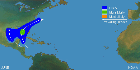
Based on climatology, the most likely spots for an early season storm are in the Gulf of Mexico or northwest Caribbean. Image provided by the National Hurricane Center.
A busy season does not always mean that multiple storms (or any storms for that matter) will impact the United States, though last year saw much of the Gulf Coast and East Coast threatened by tropical systems. In 2010, 19 named storms were observed in the Atlantic, 12 of them became hurricanes, and 5 were major hurricanes. Only one storm made landfall in the United States, and that was Bonnie, which was a minimal tropical storm at landfall. In 1990, there were a total 14 named storms, 8 of them hurricanes and 1 major hurricane. Not a single one of them made landfall in the United States. On the flip side, an inactive year doesn’t mean much for landfall probabilities as well. Only 7 named storms formed in 1992, and the 1st one didn’t develop until August 16. That storm, however, was named Andrew, and it made landfall just south of Miami as a category 5 storm. It only takes one storm to ruin your entire year.
Here in New England, we should always pay attention when a storm is nearing the Bahamas, as those are the ones that have the potential to impact us, and we are very overdue for a system to impact us. Using data back to 1851, here are some stats that show how overdue we are:
Since 1851, 36 storms of tropical storm strength of greater have made landfall in New England or Long Island, an average of one every 4.7 years. The longest we’ve ever gone without one is 11 years, between 1897 and 1908 and also between 1923 and 1934. We’re at 10 years since Irene, the last one to do so.
Since 1851, 29 strong tropical storms (maximum sustained winds of 60 mph or more) have made landfall in New England or Long Island, an average of one every 5.9 years. The longest we’ve ever gone without one is 19 years, between 1897 and 1916. We’re at 10 years since Irene, the last one to do so.
Since 1851, a hurricane has made landfall in New England or Long Island 18 times, an average of one every 9.4 years. The longest we’ve ever gone between hurricane landfalls is 38 years, between 1896 and 1934. It’s been 30 years since Bob, our 2nd longest drought on record.
Since 1851, 9 hurricanes of Category 2 intensity or stronger have made landfall in New England or Long Island, an average of one every 18.9 years. The longest we’ve gone between hits by storms of that intensity is 69 years, between 1869 and 1938. We’re at 30 years since Bob, the last one to do so.
Since 1851, New England/Long Island has had 3 Major Hurricanes (Category 3 or higher) make landfall – an unnamed storm in October of 1869, the infamous 1938 Long Island Express, and Hurricane Carol in 1954. That’s an average of 1 every 56.7 years, and the longest time between 2 major hurricanes is 69 years (1869-1938). We’re at 67 years since Carol. There are also 3 documented storms from before 1851 – The Great Colonial Hurricane of 1635, the 1815 New England Hurricane, and the Norfolk and Long Island Hurricane of 1821. That’s it. That changes the numbers to 6 in 386 years, or one every 64.3 years, with a longest drought of 180 years.
Satellite photo of Hurricane Bob approaching New England. Bob was the last hurricane to make landfall in New England – 30 years ago. Image provided by NOAA.
We all saw what Sandy did in 2012, and that was a minimal hurricane that eventually made landfall in southern New Jersey (technically as an extratropical storm). When (not if) the next big storm comes up the coast, much of this region will not be prepared for the storm or its aftermath.
The Atlantic is quiet right now, but even if something were to form off the East Coast in the next few weeks and head this way, the waters off of New England are much too cold to sustain a tropical system, so we’d see something more like a typical nor’easter. Only two tropical storms have ever made landfall in the Northeast before the end of June. The first was an unnamed minimal tropical storm that crossed extreme eastern Long Island and went into southeastern Connecticut on May 30, 1908. The other was Tropical Storm Agnes, which made landfall near New York City on June 22, 1972, then caused devastating flooding across parts of the Mid-Atlantic states. In terms of hurricanes, the earliest one to ever make landfall up this way was Hurricane Belle, which slammed into Long Island with 90 mph winds on August 9, 1976. We did have Hurricane Arthur pass just offshore of Nantucket on July 4, 2014. While it did not make landfall, it made for a rather wet and cool holiday, especially across Cape Cod and southeastern Massachusetts. Statistically, the most likely time for a hurricane to hit New England is between the middle of August and late September. Of the 18 hurricanes that made landfall in New England or Long Island since 1851, 15 of them have done so between August 19 and September 27.
The most likely time for a tropical system to impact our area is August or September. Image provided by the National Weather Service office in Norton, MA.
As always, you should get your weather information from a trusted source, especially when dealing with tropical systems. Much like with snowstorms in the winter, there will be plenty of hype and exaggeration on Twitter and Facebook, as well as people posting doom and gloom maps showing how a thunderstorm near the coast of Africa will develop into a Category 5 storm and head right for the East Coast in the next 2 weeks. We’re not among that group, we give you facts and our best forecasts, without any hype. If there’s reason to worry, we’ll let you know with plenty of advance warning. It’s always best to prepare ahead of the season. Chances are, you won’t have anything to worry about, but in case you do, it’s always good to be prepared, as we’ve learned recently.