Labor Day Weekend is coming up? Summer is definitely fading, except that you won’t notice that for the next few days. That’s right, a late-summer heat wave is settling in.
A ridge of high pressure will settle into the East Coast for the next few days while at the surface high pressure remains in place off the East Coast. That means hot and humid conditions through the middle of the week. Heat Advisories and Excessive Heat Watches are in effect across much of the Northeast. High temperatures will get well into the 90s for much of the area, but when you factor in the dewpoints well into the 70s, the heat index will be well over 100.
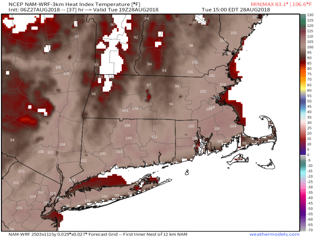
The heat index will likely be over 100 across much of the area Tuesday afternoon. Image provided by Weathermodels.com
A cold front comes through on Thursday, triggering some showers and thunderstorms, and bringing cooler and drier air in. Behind that front, high pressure settles into eastern Canada. Labor Day Weekend might start off quite cool, but as the high slides off to the East, temperatures will start to warm up for the latter half of the holiday weekend. There is one potential fly in the ointment. That front that is coming through on Thursday is likely going to stall out south of New England. Depending on how close it stalls, it may keep clouds and possibly some showers in place, especially along the South Coast. We’ll see how that plays out as we get later on the week.
Monday: Sunshine and a few clouds. High 85-92.
Monday night: Clear to partly cloudy. Low 67-74.
Tuesday: Mostly sunny, hot, and humid. High 90-97.
Tuesday night: Clear skies. Low 71-78.
Wednesday: Mostly sunny, hot, and humid again. High 90-97.
Thursday: A mix of sun and clouds, chance for some showers and thunderstorms. High 86-93.
Friday: Partly sunny and less humid. High 70-77.
Saturday: Partly to mostly sunny. High 68-75.
Sunday: A mix of sun and clouds. High 75-82.
Labor Day: Intervals of clouds and sunshine, chance for a few showers. High 80-87.
Need more proof that summer is almost over? How about 1-2 feet of snow in the mountains of Idaho, Montana, and Wyoming over the next few days? Image provided by WeatherBell.
We’re heading towards the peak of hurricane season in the Atlantic, but it’s the Pacific where the problems are right now. In fact, we’ve got not one, not two, but three storms that may impact land later this week.
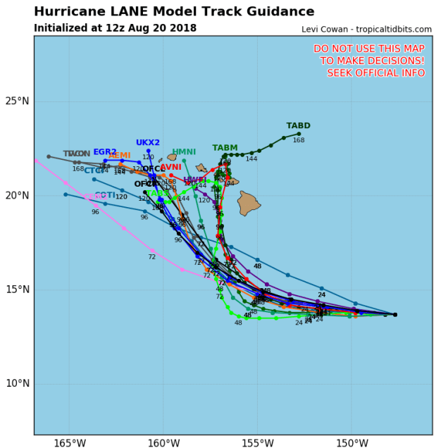
Hurricane Lane has been steadily moving across the Eastern and Central Pacific Ocean for the past week while strengthening. As of midday Monday. Lane was centered about 615 miles southeast of Hilo, Hawaii, moving towards the west at 14 mph. Lane’s maximum sustained winds peaked at 140 mph on Saturday, and have since dropped to 125 mph, meaning it is still a Category 3 Hurricane. It is expected to maintain its current intensity through Tuesday before a more pronounced weakening trend develops.
Hurricane Lane is a threat to Hawaii later this week. Will it be a direct hit or another miss? Too early to tell. Image provided by Tropical Tidbits.
The forecast track for Lane is a bit problematic. Lane is expected to continue westward for another day or two before turning more towards the northwest or north. Where it makes that turn is very important, as it will determine what, if any, impact Lane may have on Hawaii. At the very least, we’re looking some rough surf, rainfall, and gusty winds for parts of the island chain. However, a closer pass brings stronger winds and heavy rain in, especially to some of the northwestern islands.
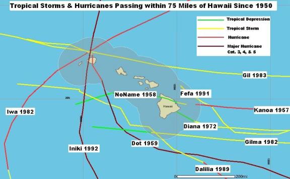
Map showing all tropical storms and hurricanes that have passed with 75 miles of the Hawaiian Islands. Image provided by the Central Pacific Hurricane Center.
As we mentioned in our Weekly Outlook, Hawaii doesn’t get direct hits from hurricanes very often. In fact, since their tropical cyclone records began in 1950, only 3 hurricanes have made direct hits on Hawaii – Hurricane Dot in 1959, Hurricane Iwa in 1982, and Hurricane Iniki in 1992 – all of which hit the island of Kauai . Dot and Iwa were both Category 1 storms when they hit, while Iniki was a Category 4 storm. There have been a lot more tropical storms that have hit the islands, and hurricanes that passed close enough to impact part of the island chain, but only those 3 have had direct impacts.
Typhoon Soulik has a rather large eye at the moment. Loop provided by NOAA.
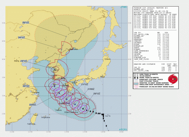
Heading much farther to the west, Typhoon Soulik is threatening parts of Japan and South Korea. As of midday Monday, Soulik was centered about 415 miles east of Okinawa, moving toward the west-northwest at 12 mph. Soulik has maximum sustained winds near 115 mph, and is expected to maintain that intensity for the next 24-36 hours. After that it should start to weaken a bit while turning more toward the northwest as it crosses the Ryukyu islands southwest of Japan. After that, a turn more towards the north and steady weakening are expected as Soulik heads for the coast of South Korea. If the storm makes the northerly turn a little later than currently anticipated, it could remain over the Yellow Sea a little longer, and make landfall in North Korea instead, likely in a somewhat weaker state. Either way, strong winds, heavy rainfall, and flooding are likely across the Korean Peninsula towards midweek.
Typhoon Soulik is expected to hit Korea later this week. Image provided by the Joint Typhoon Warning Center.
A little southeast of Soulik is Typhoon Cimaron, which is pulling away from the Northern Mariana Islands. Cimaron is a minimal typhoon with maximum sustained winds near 75 mph, but steady strengthening is expected over the next 24-36 hours. Cimaron is expected to take a northwest track, passing close to Iwo Jima before turning more towards the north by midweek. After that it will likely head towards Japan, with landfall expected later this week as a minimal typhoon, likely around the same time that Soulik is impacting Korea. Cimaron will bring strong winds, and heavy rain to an area that was already recovering from deadly flooding earlier this summer.
Forecast track for Typhoon Cimaron. Image provided by the Japanese Meteorological Agency.
While the Pacific remains somewhat active, the Atlantic is still quiet. While the forecast models show this continuing for the remainder of August, climatology says that the trend won’t continue into September, as the peak of hurricane season is mid-September climatologically. The pattern remains unfavorable for storms to form now, but it remains to be seen if that pattern will continue into September.
Yesterday was the 27th anniversary of Hurricane Bob’s landfall in Southern New England. Image provided by the National Weather Service office in Norton, MA.
While talking about the Atlantic and climatology, we’d be remiss if we didn’t mention that yesterday was the 27th anniversary of Hurricane Bob slamming into Southern New England. If 27 years seems like a long time, you’d be correct. Using data back to 1851, a tropical storm makes landfall in Southern New England or Long Island once every 4 years, while a hurricane makes landfall once every 8 years. The last tropical storm to make landfall was Irene, which passed right over New York City in 2011, so we’re about due for another one. As for hurricanes, while we’ve been threatened several times in the past few years, that 27-year gap since Bob is the 2nd longest on record, second only to the 28 year gap between 1896 and 1924. In other words, we are very overdue. There are a lot of people that live around here that have never experienced a hurricane. We saw storms wreak havoc and create lots of damage around here last winter. If a full-fledged hurricane were to make landfall, especially one that’s a Category 2 or 3, we’d be in real trouble. Only 3 Major Hurricanes (Category 3 or higher) have made landfall in New England, and the last was Carol in 1954. The other 2 were a storm in September of 1869, and another one you have heard about before that hit the area in September of 1938. If one of those comes along again, the damage Sandy brought to this area would probably look minor in comparison.
The heat and humidity have finally departed. Don’t worry, the humidity will be coming back again this week, but only briefly. Then, once it leaves again, the heat might come back. Yup, we’ve got an interesting week coming up.
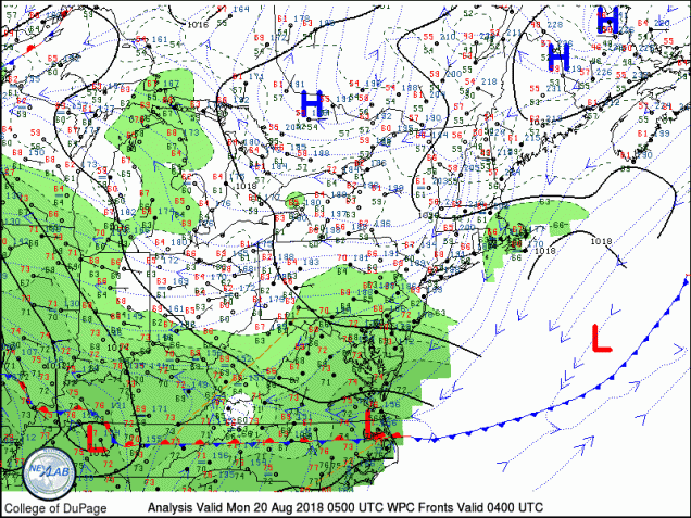
High pressure is moving into New Brunswick this morning while a cold front is stalled out across North Carolina. Image provided by the College of DuPage
The week starts off with a frontal system stalled out south of New England and high pressure over New Brunswick. When you combine those two, you get a northeasterly flow, bringing in relatively cool and drier conditions. In the Spring, when water temperatures are only in the 40s or 50s this would result in temperatures in the 40s or 50s along the coast, while areas well inland might get into the 70s (or warmer). However, since it’s mid-August, water temperatures are in the lower to middle 70s, so a northeast wind means temperatures will be in the lower to middle 70s along the coast, and upper 70s to lower 80s inland.
It has been a VERY warm August thus far, which makes days like yesterday, today, and tomorrow feel even more refreshing. Image provided by the Northeast Regional Climate Center.
Another cold front will start to move towards the area on Tuesday. We’ll have another relatively cool day, but clouds will start to move in. Tuesday night into Wednesday is when we notice bigger changes. A warm front moves through, bringing heat and humidity back into the area. With the warm and humid conditions will also be some thunderstorms. Much like many days over the past month or so, we’re not expecting any widespread severe weather, but a few places could get hit with a nasty storm that contains gusty winds and heavy downpours.
By Thursday, high pressure builds into the region, with seasonably warm conditions for the end of the week and into the weekend. Humidity levels will be fairly low to start, but should rise a bit for the weekend. While most of the region should remain dry as well, a few showers and thunderstorms are possible, mainly on Thursday as an upper-level low pressure area moves across the Northeast.
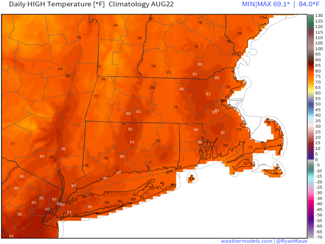
On average, high temperatures should be in the upper 70s to lower 80s during the latter half of August around here. Image provided by Weathermodels.com
Monday: A few showers or some drizzle are possible in the morning, mainly south of Boston. Otherwise, intervals of clouds and sunshine, a little breezy, especially along the coast. High 71-78, coolest along the coast.
Monday night: Partly cloudy. Low 56-63.
Tuesday: Partly sunny. High 70-77.
Tuesday night: Mostly cloudy, showers and thunderstorms developing, mainly after midnight. Low 63-70.
Wednesday: Breezy with occasional showers and thunderstorms, some of which could be heavy at times. High 77-84.
Thursday: Partly to mostly sunny, slight chance for a pop-up shower or thunderstorm. High 73-80.
Friday: Sunshine and a few clouds. High 77-84.
Saturday: A mix of sun and clouds. High 78-85.
Sunday: Partly to mostly sunny. High 79-86.
Hurricane Lane could be a threat to Hawaii later this week. Image provided by Tropical Tidbits.
Meanwhile, in the tropics, the Atlantic remains fairly quiet, but in the Pacific, we could have some trouble in paradise. As of early this morning, Hurricane Lane was centered a little more than 700 miles east-southeast of Hilo, Hawaii, moving towards the west at about 14 mph. Lane had maximum sustained winds around 120 mph. It is expected to gradually weaken over the next several days, while heading westward, before turning more toward the northwest. Where it makes that northwest turn is very important, as it will determine what, if any, impact Lane may have on Hawaii. At the very least, we’re looking some rough surf and some gusty winds, especially across the Big Island. However, a closer pass brings stronger winds and heavy rain in, possibly to more than just the Big Island. Hawaii doesn’t get direct hits very often. In fact, since their tropical cyclone records began in 1950, only 3 hurricanes have made direct hits on Hawaii – Hurricane Dot in 1959, Hurricane Iwa in 1982, and Hurricane Iniki in 1992 – all of which hit the island of Kauai . Dot and Iwa were both Category 1 storms when they hit, while Iniki was a Category 4 storm. There have been a lot more tropical storms that have hit the islands, and hurricanes that passed close enough to impact part of the island chain, but only those 3 have had direct impacts.
The forecast for the upcoming week is both simple, and not-so-simple at the same time. If it feels like you’ve heard this before, it’s because you have. The pattern has remained fairly persistent for a while now, but the subtle details make all the difference.
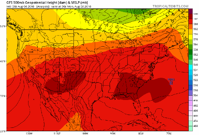
High pressure remains off the East Coast, keeping warm and humid air in place for much of the week. Loop provided by Tropical Tidbits.
That stubborn Bermuda High remains in place off the East Coast for much of the week, which means the warm and humid pattern that we’ve been in for a while will continue. However, there are some differences in the pattern that will have other impacts. A frontal system remains stalled out near the East Coast. With an upper-level low pressure system across the Northeast, we’ll have little impulses of energy move through, bringing in some rounds of showers and thunderstorms over the next few days. None of these days will be a washout, and some of the rain will be very localized, but anything that does form could produce some heavy rainfall. This was the case over the weekend, when localized totals of 4 to as much as 8 inches produce flash flooding in a few spots.
Many locations received between 1 and 4 inches of rain over the weekend. Some localized totals in excess of 8 inches were reported near Lynn, Massachusetts. Image provided by NOAA.
The upper-level low moves out by mid-week, resulting in less showers and thunderstorm activity, and an increase in temperatures once again. Don’t worry, humidity levels will remain moderate to high right through the week. We could be looking at some places topping 90 again during the latter half of the week. By the weekend, another cold front (an another upper-level trough of low pressure) will approach the region. That means that we could be looking at more showers and thunderstorms. Again, we’re not expecting either day to be a washout right now, so don’t go cancelling any plans just yet. However, we’d have a backup plan ready, just to be safe. With the airmass remaining quite humid, we’d expect any showers and storms next weekend to again produce some locally heavy rainfall.
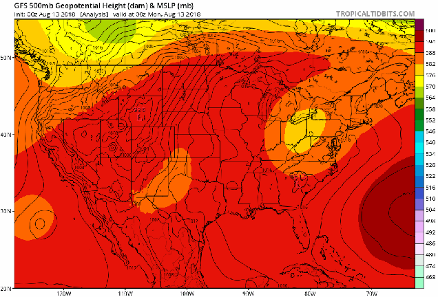
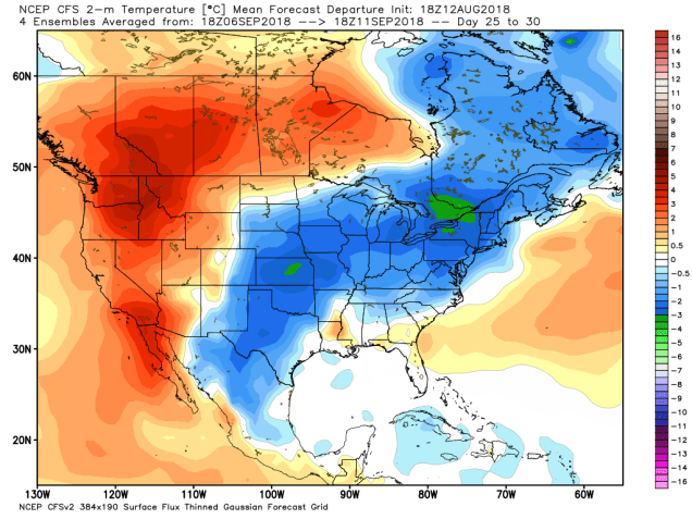
So, how much longer will this pattern last? We usually don’t delve into forecasts beyond 7 days, as the models don’t show a lot of skill beyond that, but for now, it looks like we’re locked in for at least a couple more weeks. Beyond that? There are some signs that we could shift into a cooler pattern as we get into early September. Obviously, this is not written in stone, and the cool weather may not even last too long. However, it can’t stay warm and humid forever. The days are getting shorter, meteorological autumn starts in less than 3 weeks, astronomical autumn starts in less than 6 weeks, and most importantly, the Patriots open the regular season 4 weeks from yesterday. Before you know it, we’ll be talking about that 4-letter word that begins with “s” that so many of you hate.
The CFS model shows some much cooler air settling into the eastern half of the nation during early September. Will it actually happen? We’ll see. Image provided by WeatherBell.
Monday: Intervals of clouds and sunshine, chance for some showers, maybe a rumble of thunder. High 73-80.
Monday night: Partly to mostly cloudy, maybe a lingering shower or two. Low 65-72.
Tuesday: Partly sunny, some showers and thunderstorms are possible, mainly in the afternoon. High 78-85.
Tuesday night: Partly cloudy, a few lingering showers are possible. Low 64-71.
Wednesday: A mix of sun and clouds, slight chance for a shower. High 81-88.
Thursday: Partly to mostly sunny, a pop-up shower or thunderstorm may develop in the afternoon. High 83-90.
Friday: Sunshine and some afternoon clouds, a few showers or thunderstorms can’t be ruled out. High 83-90.
Saturday: Partly sunny, chance for some showers and thunderstorms. High 79-86.
Sunday: More clouds than sunshine, more showers and thunderstorms are possible. High 74-81.
Another week gone by filled with heat and humidity, as well as some thunderstorms. Can we expect more of the same this week? Yes, at least for part of the week, though some subtle changes are coming.
Changes in the upper-level pattern will mean changes in our weather later this week. Loop provided by Tropical Tidbits.
The reason for heat and humidity has been a persistent ridge of high pressure in the Eastern US for most of the past few weeks. As you can see in the loop above, that ridge is forecast to shift into the Western US later this week, while a trough of low pressure settles into the Northeast. What does that mean in terms of actual weather? We’ll explain.
The combination of heat and humidity will result in heat indices int he upper 90s across most of the region this afternoon. Image provided by Weathermodels.com
With the ridge of high pressure in place aloft, we’ve also had high pressure at the surface, pumping warm and humid air into the region. That will continue today, and likely on Tuesday as well, though a frontal system approaching the region may produce a few showers and thunderstorms later Tuesday. That front will draw closer on Wednesday, likely moving through the region early Thursday. Ahead of it, more showers and thunderstorms are expected, some of which could be locally heavy. Depending on the timing of the front, severe weather is not out of the question. We’ll keep an eye on that as it gets closer.
We’ve had several fronts attempt to move through the region over the past few weeks, but as they run into that high pressure area at the surface and aloft, they end up stalling out and dissipating. With the ridge shifting westward and a trough of low pressure moving into the region, it will help provide enough impetus to help this front move offshore. Now, it’s not much of a “cold” front, as temperatures will still be warm to hot for the end of the week and into the weekend, but the most noticeable effect will be on the humidity. Humidity levels will drop on Thursday, with dewpoints in the upper 60s and 70s replace by dewpoints in the 50s to lower 60s for Thursday and Friday. Another frontal system may approach over the weekend, possibly bringing in some additional showers and thunderstorms, but also raising humidity levels a little.
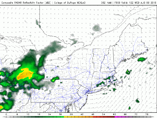
We don’t normally get a lot of thunderstorms overnight around here, especially severe ones, but it has happened a few times already this summer. At least one model shows the potential for more activity Wednesday night into Thursday morning. Loop provided by the College of DuPage.
Monday: Some patchy fog early, otherwise sunshine and some high clouds, humid. High 89-96.
Monday night: Mostly clear. Low 68-75.
Tuesday: Sunshine and some afternoon clouds, slight chance for a late-day shower or thunderstorm, humid. High 88-95.
Tuesday night: Partly cloudy, a few showers or thunderstorms are possible, mainly during the evening. Low 68-75.
Wednesday: Partly sunny, with scattered showers and thunderstorms developing late in the day, with more possible overnight. High 84-91.
Thursday: Early showers and thunderstorms, then skies clear out in the afternoon. High 81-88.
Friday: A mix of sun and clouds, slight chance for a shower or thunderstorm. High 82-89.
Saturday: Partly sunny with some showers and thunderstorms possible. High 79-86.