Weekly Outlook: October 30 – November 5, 2023

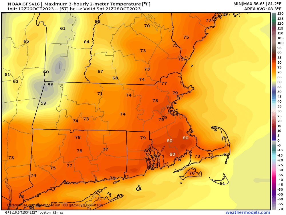
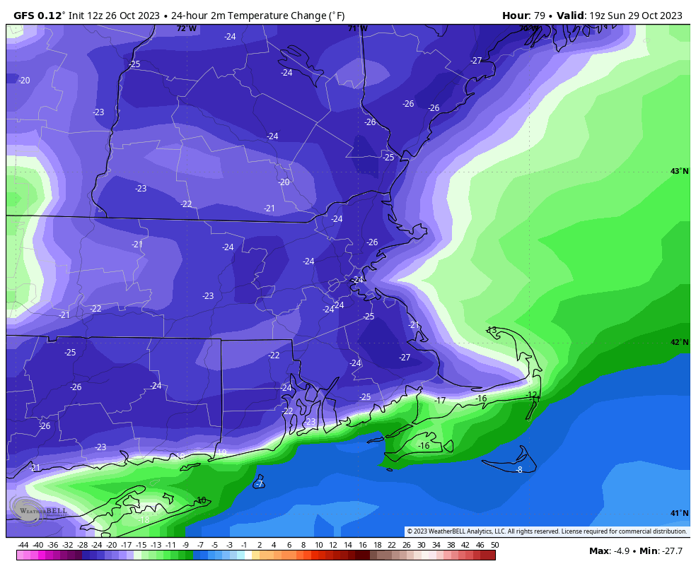
The warm weather is gone and won’t be back anytime soon.

Temperatures will be several degrees below normal for much of the upcoming week. Image provided by WeatherBell.

Low pressure rides along a frontal system stalled out across the region today, bringing us a chilly rain. Temperatures will end up a bit milder south of the front today, especially along the South Coast, possibly as far north as the Mass Pike. Rain ends this evening as the wave moves offshore, then high pressure builds in with clearing Monday night. Halloween starts off with sunshine and cool temperatures, but clouds start to move back in during the afternoon. A developing coastal system will pass south and east of the region late Tuesday night and Wednesday. Some rain is expected across parts of southeastern New England, but how far north and west the precipitation gets is still a question mark. Once you get north and west of I-495, the chances drop quickly. However, with some colder air in place, the rain may start as some wet snow. We’re not expecting any accumulation, but if you’re out an about early Wednesday morning, don’t be surprised if you see some wet snowflakes. That system quickly pulls away with skies clearing out in the afternoon. High pressure then builds back in with sunshine and chilly conditions for Thursday. Temperatures will slowly moderate for Friday into Sunday as the high moves offshore, with temperatures getting back above normal next weekend, but we’re talking into the 60s, not the 70s and 80s we just had. An approaching cold front spreads clouds in on Sunday, but it looks like any rain should hold off until Sunday night or Monday.

A couple of models show the potential for some wet snow to mix with the rain Wednesday morning. Image provided by Pivotal Weather.

Monday: Periods of rain and showers, ending late in the day. High 48-55 north of the Mass Pike, 56-63 south of the Pike.

Monday night: Becoming partly cloudy to clear. Low 32-39.

Tuesday: Mostly sunny during the morning, clouds start to move back in during the afternoon. High 44-51.

Tuesday night: Becoming partly to mostly cloudy with showers developing across southeastern Massachusetts late at night. Low 30-37.

Wednesday: Some showers around in the morning, maybe a few wet snowflakes mixed in, mainly across eastern Massachusetts, skies start to clear out late in the day. High 42-49.

Thursday: Plenty of sunshine. High 45-52.

Friday: A mix of sun and clouds, breezy, not as cool. High 52-59.

Saturday: Partly sunny. High 55-62.

Sunday: Intervals of clouds and sun, breezy, and mild. High 57-64.

Weekend Outlook: October 27-30, 2023

The warm weather continues into the start of the weekend, but big changes are on the way.

Temperatures could reach 80 in some spots on Saturday. Image provided by Weathermodels.com

A ridge of high pressure remains in control through Saturday, keeping temperatures well above normal. In fact, with plenty of sunshine both Friday and Saturday, we may make a run at 80 degrees in some spots. Friday night will be rather mild, with our low temperatures fairly close to our normal high temperatures for late-October. A cold front moves through Saturday evening, with clouds streaming in along with it. Sunday will feature plenty of clouds, and it will turn much cooler, but we’ll still be close to normal for this time of year. A wave of low pressure riding along the front brings in some rain during the afternoon. Occasional showers will continue for Sunday night and a good chunk of Monday as the cooler air continues to filter in. As the wave and the front push farther offshore later Monday, we may see some clearing develop as high pressure starts to build in. A much cooler pattern settles in for next week with below normal temperatures. Some of the models show the potential for a storm later Tuesday into Wednesday which may not be all rain if you’re well inland, and could impact trick-or-treating Tuesday evening, but we’ll get into more detail on that in our Weekly Outlook Monday morning.

Sunday afternoon will be 20-25 degrees cooler than Saturday afternoon across the region. Image provided by WeatherBell.

Thursday night: Partly to mostly cloudy. Low 53-60.

Friday: Becoming mostly sunny and warm. High 73-80.

Friday night: Clear skies. Low 54-61.

Saturday: Sunshine and a few clouds, breezy, and warm. Clouds may start to increase late in the day. High 73-80.

Saturday night: Becoming partly to mostly cloudy and turning cooler. Low 43-50.

Sunday: Cloudy and much cooler with showers developing in the afternoon. High 54-61.

Sunday night: Occasional showers. Low 44-51.

Monday: Showers gradually ending, some clearing possible late in the day. High 55-62.

Weekly Outlook: October 23-29, 2023

The week starts off cool, but you’re really going to enjoy the second half of the week.

Frost is possible across portions of the interior Tuesday morning. Image provided by WeatherBell.

An upper-level low pressure area lifts out today, then high pressure starts to build in. This will result in clearing with breezy conditions today. The winds die down tonight, and with clear skies, we’ll be rather chilly. Some frost is likely away from the coast and urban areas. However, some high clouds will start to filter in overnight, which will act to level temperatures off. If the clouds move in a little quicker, that may prevent frost in some areas. Tuesday should feature sunshine after the clouds move out in the morning, with temperatures starting to moderate. High pressure moves offshore on Wednesday, and temperatures really start to warm up, possibly topping 70 in some locations. Another upper-level disturbance will bring in some clouds for late Wednesday and Thursday, but we’ll remain dry. Even warmer weather is expected for Thursday and Friday with temperatures likely getting well into 70s, possibly even approaching 80 in some spots on Friday. Saturday also looks warm, but some clouds will start to move in as a cold front approaches the region. Sunday’s forecast depends on the timing of the cold front. A disturbance riding along it will bring in some showers, but will the front move through Saturday night, or will it wait until later Sunday? If it’s earlier, Sunday will be much cooler than Saturday. If it’s later, then it’ll be another very warm day despite the cloudcover and showers. Once the front does move through, even cooler weather settles in for the start of the following week.

Sunday could be very warm, or quite a bit cooler. The models don’t agree right now. Images provided by Pivotal Weather.

Monday: Becoming partly to mostly sunny. High 55-62.

Monday night: Clear and chilly, some clouds start to filter in after midnight. Low 34-41, except 41-48 in urban areas and near the coast.

Tuesday: Early clouds, then becoming mostly sunny. High 56-63.

Tuesday night: Clear to partly cloudy. Low 44-51.

Wednesday: Morning sun, increasing afternoon clouds, milder. High 64-71.

Thursday: Sunshine and some afternoon clouds. High 70-77.

Friday: Partly sunny. High 70-77.

Saturday: A mix of sun and clouds, breezy. High 71-78.

Sunday: Partly to mostly cloudy and cooler with a chance of showers. High 61-68.

Weekend Outlook: October 20-23, 2023

For a change, it’s going to rain this weekend. The forecast itself isn’t that simple though, so let us explain.

A cold front in the Midwest and a trough of low pressure off the South Carolina coast will be the main players in our weather for the next few days. Image provided by NOAA.

High pressure slides off to the east tonight and clouds start to stream in ahead of a cold front currently crossing the Great Lakes. Meanwhile, a weak area of low pressure will begin to develop off the Carolina coast tonight and head northward. Ahead of both of these, we’ll have a cloudy but mild day on Friday. Some showers are possible during the day, but the bulk of the activity should stay to our west. Showers will become more widespread by evening as the low pressure area to the south draws closer. The combination of the low and the approaching front will produce widespread showers with some bouts of steadier rain through Friday night and Saturday morning, tapering off during the afternoon. While the rain won’t be heavy, some places could see an inch or so by the time it winds down. By Saturday night, the cold front and the low pressure area move offshore, but an upper-level disturbance will move into the Northeast. This will allow the low to slow down or even stall out in the Gulf of Maine while intensifying. This may keep the showers around across parts of Southern Maine and Southern New Hampshire, possibly northern Massachusetts as well, but for most of us, it’ll just be a blustery and cool day with only a few showers around.

Sunday could end up as another damp day according to some of the models. Images provided by Pivotal Weather.

High pressure finally starts to build in for Monday with some clearing, but it will remain breezy and cool. In fact, as winds subside Monday night, and skies become clear, we’ve got a chance for our first widespread frost of the fall. So, if you’ve got some outdoor plants, you may want to prepare to bring them inside.

Monday night will be the coolest night we’ve had around here since the middle of May. Image provided by WeatherBell.

Thursday night: Increasing clouds. Low 46-53.

Friday: Mostly cloudy, chance for a few showers. High 60-67.

Friday night: Cloudy with showers likely. Low 52-59.

Saturday: Cloudy with occasional showers and some periods of steadier rain. High 57-64.

Saturday night: Partly to mostly cloudy, showers ending in the evening, becoming breezy. Low 45-52.

Sunday: More clouds than sun, windy, cooler, more showers possible, especially from the Merrimack Valley northward. High 52-59.

Sunday night: Becoming partly cloudy, breezy. Low 38-45.

Monday: A mix of sun and clouds, breezy, especially in the morning. High 53-60.

Weekly Outlook: October 16-22, 2023

There is some more rain in our future, probably on the weekend again, but at least we’re not talking about snow yet.

Another upper-level low will keep us cool and unsettled today. Image provided by Tropical Tidbits.

The week starts off with an upper-level low sitting over New England, keeping us cool and unsettled to start the week. A disturbance rotating around the low may trigger some showers today, but the day won’t be a washout. The upper low starts to lift out on Tuesday, but there will remain enough instability to produce plenty of clouds and possibly a few more showers. High pressure builds in for Wednesday and Thursday with drier and milder weather, but we’ll see more clouds streaming in Thursday night and Friday ahead of another low pressure system. The main storm system will head into the Great Lakes while a secondary low pressure area develops across the Mid-Atlantic states and lifts northward into the region on Saturday, bringing us another round of rain. Right now, the consensus among the models is to develop a rather potent low pressure system and move it up the Hudson Valley during the day Saturday. This would result in a breezy, mild, and showery day, rather than a complete washout. Obviously, there’s plenty of time for things to change, so we’ll be keeping a close eye on it. Another upper-level low moves in for Sunday with more clouds, some showers, and cooler temperatures.

Some mild weather by mid-October standards is expected later this week. Image provided by WeatherBell.

Monday: More clouds than sun, chance for a few popup showers. High 53-60.

Monday night: Partly to mostly cloudy, showers taper off in the evening. Low 42-49.

Tuesday: Partly sunny, chance for another shower or two. High 55-62.

Tuesday night: Partly cloudy. Low 42-49.

Wednesday: A mix of sun and clouds. High 57-64.

Thursday: Partly to mostly sunny, breezy. High 60-67.

Friday: Mostly cloudy, breezy, showers develop at night. High 61-68.

Saturday: Mostly cloudy, breezy, scattered showers likely. High 59-66.

Sunday: Partly sunny, windy, cooler, chance for a few showers. High 54-61.

Weekend Outlook: October 13-16, 2023

A weekend without rain? Those have been rare since June, but for many of us, it will be a reality this weekend.

Average high temperatures for mid-October are in the lower to middle 60s. Images provided by Weathermodels.com

A weak cold front will cross the region this evening with little fanfare. Behind it, northwest winds will usher some cooler air in for Friday, but we’ll also have a decent amount of sunshine, with seasonably cool temperatures. Low pressure will then start to move out of the Great Lakes and head toward the Mid-Atlantic states. That will send some clouds in for Saturday, but the low should be far enough to the south that most of the rain stays offshore as well. A few showers are possible later Saturday into early Sunday near the South Coast, and there could be a little drizzle near eastern coastal locations, but for the most part we’ll stay dry. We may see a bit more sunshine on Sunday, but clouds come back Monday as another system moves off the Mid-Atlantic coastline. This may bring in a few showers on Monday, but it looks like most of the rain from this system likely holds off until Tuesday.

Some models bring the rain to the South Coast Saturday evening, some don’t. Images provided by Pivotal Weather.

Thursday night: A few clouds and possibly a stray shower during the evening, otherwise clear. Low 40-47.

Friday: Mostly sunny, breezy. High 57-64.

Friday night: Clear during the evening, some clouds move in overnight. Low 41-48.

Saturday: Becoming partly to mostly cloudy, a late-day shower possible near the South Coast. High 57-64.

Saturday night: Partly to mostly cloudy, a shower or two possible near the South Coast. Low 41-48.

Sunday: More clouds than sunshine, breezy. High 56-63.

Sunday night: Partly to mostly cloudy. Low 43-50.

Monday: Mostly cloudy, breezy, chance for a shower or two. High 55-62.

Weekly Outlook: October 9-15, 2023

Yup, that same weather pattern is still in place that has been for a while now, and another rainy weekend could be coming.

An upper-level low pressure area will remain in place across southeastern Canada through a good chunk of the week, which means temperatures will be below normal, but it shouldn’t be as wet. Monday should be fairly dry, though northeast winds may result in a few ocean-effect rain showers, mainly across Cape Cod and the Islands. A weak frontal system may bring in a few more showers on Tuesday, then high pressure builds in for Wednesday. Another weather system brings in more clouds on Thursday, and possibly a few showers. High pressure noses back in from the north on Friday with some drier weather once again, which brings us to the weekend.

Temperatures will be below normal for the next few days. Image provided by WeatherBell.

Low pressure will move out of the Great Lakes and towards the region later Friday before a secondary low pressure area develops off the Mid-Atlantic coastline, passing south of the region over the weekend. There is some discrepancy among the models in regards to the timing of the system. Some modes have another rainy Saturday into parts of Sunday, some have the rain hold off until Saturday evening, but possibly continue into Monday. Hopefully, we’ll have a better idea of the timing as we get to our Weekend Outlook on Thursday.

The models don’t agree on the timing or placement of low pressure to our south next weekend. Images provided by Pivotal Weather.

Monday: Intervals of clouds and sun, slight chance for a shower across Cape Cod and the Islands. High 57-64.

Monday night: Partly cloudy. Low 40-47.

Tuesday: A mix of sun and clouds, a shower or two possible. High 59-66.

Tuesday night: Partly to mostly cloudy. Low 41-48.

Wednesday: Partly to mostly sunny. High 61-68.

Thursday: Partly to mostly cloudy, breezy with a chance of showers. High 60-67.

Friday: A mix of sun and clouds. High 58-65

Saturday: Cloudy and breezy with a chance of rain. High 55-62.

Sunday: Rain likely, breezy. High 52-59.

Weekend Outlook: October 6-9, 2023

Another rainy Saturday? Yup, we’ve got another rainy Saturday on the way.

Tropical Storm Philippe may have a role in our weather this weekend. Image provided by the National Hurricane Center.

We start off with another foggy night tonight, with plenty of moisture around and high pressure sliding off to the east. Once the fog burns off Friday morning, we’ll still have plenty of clouds ahead of a cold front slowing moving in from the west. A few showers are possible during the day, but they’ll become more likely at night, and through a good chunk of the day on Saturday. Complicating matters is Tropical Storm Philippe, or what’s left of it. It will be moving northward, passing east of the region, but some of the rain from it could move into eastern Massachusetts. Eventually, it’ll get tugged northwestward by an upper-level low (more on that in a minute), moving into Maine or New Brunswick this weekend, with some heavy rain and gusty winds for parts of northern New England. The cold front moves across the region Saturday evening, bringing an end to the rain, then much cooler air settles in behind it. However, that upper-level low over southeastern Canada will move southeastward, which means that despite high pressure building in at the surface, we’ll still have plenty of clouds around Sunday and Monday, with a few popup showers possible.

The heaviest rain will stay well to our west, but there is the potential for some heavy rain in eastern New England this weekend. Images provided by Pivotal Weather.

Thursday night: Becoming mostly cloudy with areas of fog, some of it dense. Low 54-61.

Friday: Partly to mostly cloudy with a chance for a shower or two. High 67-74.

Friday night: Cloudy with showers developing. Low 57-64.

Saturday: Periods of rain and showers. High 61-68.

Saturday night: Showers end, some clearing possible late at night, becoming breezy. Low 46-53.

Sunday: A mix of sun and clouds, windy, cooler. High 57-64.

Sunday night: Clear to partly cloudy, winds slowly diminish. Low 41-48.

Monday: Partly sunny, breezy. High 54-61.

Weekly Outlook: October 2-8, 2023

The first half of the week will feature some fantastic early fall weather, but the weekend isn’t looking as great.

Temperatures will average 5-10 degrees above normal between now and Friday. Image provided by WeatherBell.

High pressure will dominate the region for the next several days. The result will be sunshine and unseasonably warm temperatures through Wednesday, with clear skies, areas of fog, and mild temperatures at night. Thursday looks warm as well, but we’ll see clouds start to stream in as a cold front begins to approach from the west. Friday will feature a lot of clouds, but it will remain mild. We may see a few showers by late in the day, but most of them should hold off until after dark. Low pressure passes north of the region Friday night and Saturday, dragging the cold front through with some rain likely, but temperatures will turn cooler with the cloudcover and rain. The front moves through late Saturday, bringing an end to the rain, then high pressure builds in for Sunday with much cooler conditions. With an upper-level low also moving in, we’ll still see plenty of clouds, with a few pop-up showers possible.

The potential exists for another rather wet Saturday across the region. Images provided by Pivotal Weather.

Monday: Some clouds and a little fog to start the day, then mostly sunny. High 68-75, coolest near the coast.

Monday night: Clear skies, patchy fog develops. Low 47-54.

Tuesday: Plenty of sunshine. High 77-84.

Tuesday night: Clear skies, more fog developing. Low 55-62.

Wednesday: Sunshine with some afternoon clouds. High 75-82, a little cooler near the coast.

Thursday: A sunny start, clouds start to move in during the afternoon. High 71-78.

Friday: Mostly cloudy, not as warm, a few showers possible in the day, more likely at night. High 67-74.

Saturday: Cloudy and cooler with periods of rain and showers likely, ending overnight. High 64-71.

Sunday: Intervals of clouds and sun, breezy, much cooler, chance for a few showers. High 58-65.