Weekly Outlook: June 25 – July 2, 2017

Can you believe that we are just about at the halfway point of the year already? Yup, before you know it, we’ll be talking about football, then hockey, and snowstorms, and….well, we’ll stop there before we upset everyone.

gfs_6hr_snow_acc_wyoming_21
Yes, it’s late June, but some snow is possible in the higher elevations of Wyoming and Montana later this week. Image provided by WeatherBell.

Well, we are supposedly in the middle of summer now, but the weather pattern is definitely not a typical summertime pattern. An upper-level trough of low pressure will move into the Northeast for the start of the week. That means that we’ll start off each day with sunshine, but clouds will pop up and likely some showers or thunderstorms each afternoon. High pressure starts to build in on Wednesday with drier and milder conditions. By Thursday, a warm front will cross the region, with more showers and thunderstorms expected. Friday will finally be a typical summer day, with warm and humid conditions, but also the chance for more showers and thunderstorms. Next weekend, things get tricky again. A back door cold front will try to drop down from the north and will likely stall out somewhere in our vicinity. Exactly where it stalls will have a huge impact on the temperatures around here. South and west of the front, it will remain humid, with temperatures well into the 80s or even the 90s. North and east of the front, temperatures may stay in the 60s and lower 70s, especially near the coastline. Of course, since, it’s the start of the long holiday weekend, these details are fairly important. Hopefully, we’ll have more clarity as we head through the week.

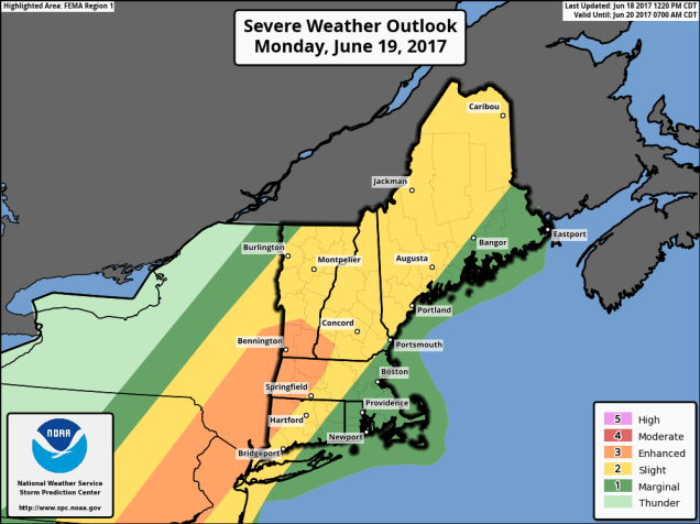
Monday: A sunny start, then clouds develop along with afternoon showers and thunderstorms. High 74-81.

Monday night: Showers and thunderstorms taper off in the evening, then skies clear out overnight. Low 52-59.

Tuesday: Clouds return along with the chance for more showers and thunderstorms. High 72-79.

Tuesday night: Clearing skies. Low 53-60.

Wednesday: Partly to mostly sunny, just a slight chance for a shower or thunderstorm. High 72-79.

Thursday: A mix of sun and clouds, breezy, chance for showers and thunderstorms, mainly late in the day and at night. High 76-83.

Friday: Partly sunny and breezy, more showers and thunderstorms may develop. High 83-90.

Saturday: A mix of sun and clouds, chance for showers and thunderstorms. High 76-83, possibly warmer well inland and cooler right along the coast.

Sunday: More clouds than sun with more showers and thunderstorms around. High 80-87.

rbtop_lalo-animated
The Atlantic remains quiet, but in the Pacific, Tropical Storm (soon to be Hurricane) Dora is intensify just off the southern Mexican coastline. Loop provided by NOAA.

Weekly Outlook: June 19-25, 2017

We apologize for the brief post this week, but we wanted to make sure we still provided you with an update, especially since Monday could be an active day.

A cold front will approach the region on Monday, and with a warm and humid airmass in place, that front will likely trigger some strong to severe thunderstorms during the afternoon and evening. The strongest storms will likely occur west of our area, but some of them will likely survive into eastern New England. Some of the storms will produce heavy downpours, strong winds, hail, and possibly even a tornado or two.

fema01_swody2
Severe weather is possible across New England on Monday, especially northern and western areas. Image provided by the Storm Prediction Center.

High pressure will build in for the middle of the week with much drier conditions. The high slides offshore late in the week, allowing warm and humid conditions to return. Another front approaches next weekend, with more showers and thunderstorms possible.

Monday: Becoming cloudy and breezy with showers and thunderstorms developing, some of which could become strong to severe. High 80-87, cooler along the South Coast.

Monday night: Showers and thunderstorms taper off in the evening, then skies clear out late at night. Low 65-72.

Tuesday: Becoming mostly sunny. High 77-84.

Tuesday night: Clear to partly cloudy. Low 57-64.

Wednesday: Sunshine and some afternoon clouds. High 75-82.

Thursday: A sunny start, high clouds start to move in during the afternoon. High 76-83.

Friday: A mix of sun and clouds, warmer, and more humid, with a chance for a few showers and thunderstorms. High 81-88, cooler along the South Coast.

Saturday: More clouds than sun with more showers and thunderstorms possible.  High 78-85.

Sunday: A mix of sun and clouds, chance for a shower or thunderstorm. High 76-83.

rb-animated
Two tropical disturbances are being monitored right now, one near the Yucatan, and one east of the Lesser Antilles. Loop provided by NOAA.

The tropics have also awakened. There a disturbance east of the Lesser Antilles that could become a tropical depression on Monday. Tropical Storm Warnings have already been issued for some of the islands. A second disturbance near the Yucatan could become more of a threat to the Gulf of Mexico later this week.

Weekly Outlook: June 12-18, 2017

Well, many of you wanted it, now you’ve got it. The heat has arrived, and the humidity will be creeping up as well. It won’t last too long though, so you’d better enjoy it while it’s here. We’ll cool off for the middle and end of the week, then start to warm back up again next weekend.

gfs_t2max_boston_5
It’s going to be quite toasty today away from the South Coast. Image provided by WeatherBell.

With a Bermuda high sitting off the East Coast and a ridge of high pressure aloft over the Eastern US, we have all the ingredients needed for a couple of hot days across the region. Plenty of sunshine and southwest winds mean temperatures should soar into the 90s again today, mainly away from the South Coast. Tuesday also looks hot, but a cold front will approach the region during the afternoon. How quickly the clouds move in ahead of the front will determine how hot we actually get. As the front moves through in the afternoon, it will trigger showers and thunderstorms. Some of the storms could be quite strong, with gusty winds, heavy, and heavy downpours. Skies clear out behind the front Tuesday night, and high pressure builds in for Wednesday and Thursday, bringing cooler temperatures with it.

Things get a little trickier for Friday and the weekend. A warm front will move through on Friday, bringing warmer and more humid air back into the region for the weekend. This will also increase the chance for showers and thunderstorms, especially on Saturday. By Sunday, another cold front will be approaching the region, which means more showers and thunderstorms are possible. The amount of cloud cover that we get each day will play a big factor in determining how warm each day ends up.

Monday: Sunshine and a few clouds, humid. High 88-95, except 80-87 along the South Coast and Cape Cod.

Monday night: Clear to partly cloudy, muggy. Low 67-74.

Tuesday: A mix of sun and clouds, scattered showers and thunderstorms in the afternoon. Some of the storms may contain hail. gusty winds, and heavy downpours. Humid with high 85-92.

Tuesday night: Becoming mostly clear. Low 58-65.

Wednesday: Partly to mostly sunny. High 69-76, cooler along the coast.

Thursday: Sunshine and some high clouds. High 68-75.

Friday: Increasing clouds, showers and thunderstorms possible late in the day and at night. High 65-72.

Saturday: Partly sunny and becoming humid, chance for showers and thunderstorms. High 70-77.

Sunday: A mix of sun and clouds, humid, more showers and thunderstorms possible. High 80-87, except 73-80 along the South Coast and Cape Cod.

sn10_acc.us_nw
Things could always be worse – several inches of snow are expected across some of the mountains of the West over the next few days. Image provided by Pivotal Weather.

Weekly Outlook: June 5-11, 2017

After a rather chilly and damp May, things haven’t changed too much to start June. In fact, the next couple of days will be downright suck-tastic (that’s a technical term). While we’ll see some improvement in this pattern as we head towards the end of the week, a flip to summer-like weather is probably still at least a week away. Even then, we’re not sure how long a summer-patter may hang around.

Stop us if you’ve heard this before, but for the first half of the week, an upper-level low pressure area will remain in place across the Northeast. That means showers and cool temperatures through at least Tuesday. A weak area of high pressure will try to build in at the surface on Wednesday, but with that upper-low hanging around, we’ll still see plenty of clouds, and possibly a few showers. In fact, that will probably be repeated each day through Saturday. None of the days will be a washout, as we won’t have any organized storm systems moving near the area. However, each day will feature plenty of clouds along with some sunny breaks, along with showers popping up. Temperatures will gradually warm up as we head through the week, but will remain below normal. As we get into the middle of June “normal” is generally lower to middle 70s, so we’re looking at highs in the 60s later this week.

gfs.500wh.conus.2017060500-loop
As has been the case for the past several weeks, an upper-level low pressure area will keep us cool and damp this week. Loop provided by Pivotal Weather.


Things *might* start to change on Sunday. By then, there are some indications that the upper-level low may start to move out and be replaced by a ridge of high pressure. That would allow for sunshine and warmer temperatures. Of course, the models haven’t been that trustworthy lately, and it was only a few days ago that they showed this transition taking place towards Thursday or Friday, not Sunday. So, we remain a bit skeptical that it will occur by Sunday.

gfs_t2m_a_f_boston_8
Temperatures will be 15-25 degrees below normal Tuesday afternoon. Image provided by WeatherBell.

Just think, it could have been a lot worse. If we had this pattern in January and February instead of May and early June, it would have been reminiscent of the winter of 2014-2015, when we got absolutely buried with record snow in a 6 week period.

Monday: Cloudy with occasional showers and drizzle. High 55-62.

Monday night: More showers, drizzle, and fog expected. Low 47-54.

Tuesday: Breezy and cool with periods of rain and showers expected. Temperatures hold steady for much of the day, possibly dropping a few degrees.

Tuesday night: Showers, drizzle, and fog persist. Low 44-51.

Wednesday: Partly to mostly cloudy with a chance for more showers.  High 54-61.

Thursday: Partly sunny, chance for a few showers. High 59-66.

Friday: Intervals of clouds and sunshine with additional showers possible. High 66-73.

Saturday: Partly sunny, a few more showers are possible. High 71-78.

Sunday: A mix of sun and clouds, slight chance for a shower. High 72-79.

Many models are showing the possibility that the start of next week features some real summer weather, with temperatures getting into the 90s and dewpoints near or above 70s. We’ll see if they stick to their guns as the week goes on.