Weekly Outlook: August 1-7, 2022

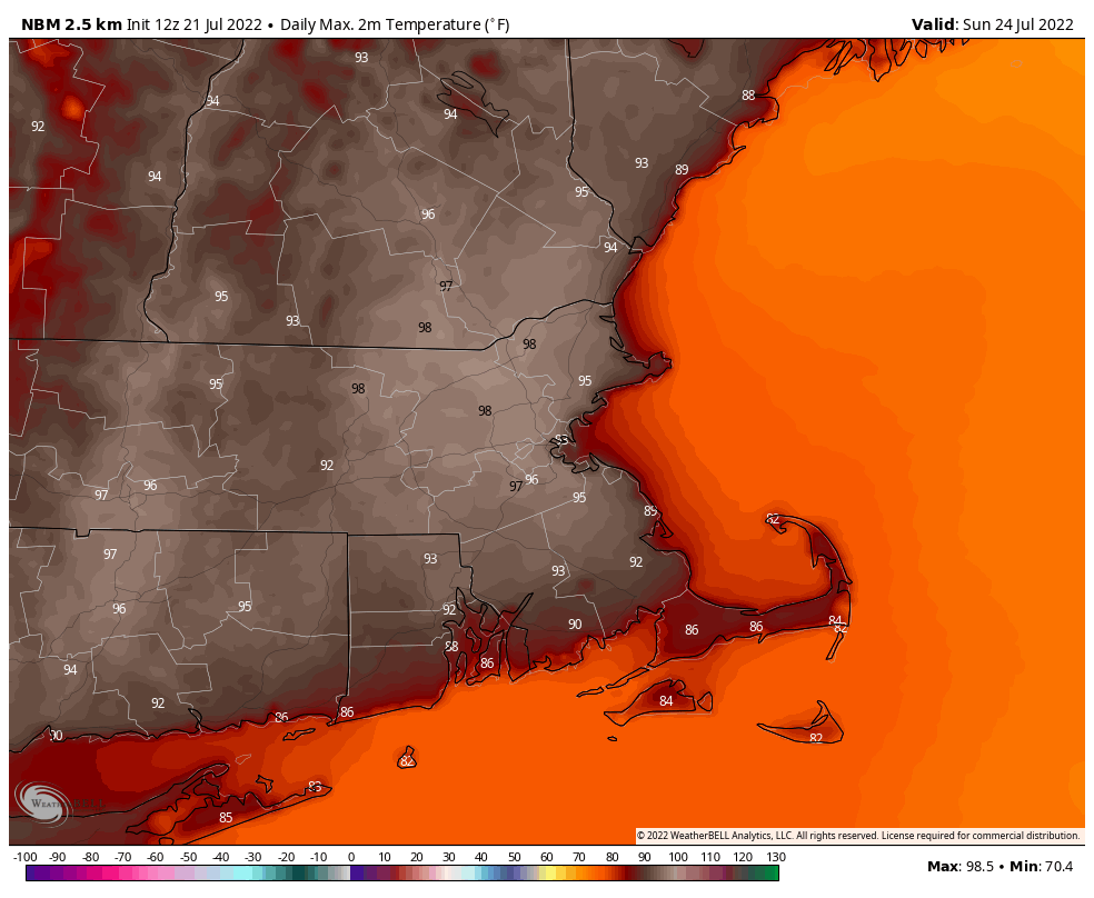
The final month of meteorological summer begins the way the last one ended – with more warm weather.

We’re actually starting the week off with some clouds, and possibly a few showers near the South Coast as a weak disturbance passes south of the region this morning. However, skies should clear out during the afternoon, with a warm and humid afternoon expected. Tuesday looks even warmer and more humid, but with a weak trough of low pressure moving through, we may see a few showers and thunderstorms develop during the afternoon. Wednesday looks to be another hot day, but it may not be quite as humid. Thursday certainly looks like the hottest day of this stretch, with some of the models are showing the potential for parts of the region to reach 100 degrees again on Thursday. We’re not quite sure it’ll be that hot, but some upper 90s are certainly plausible.

Rainfall is well below normal across the region since the start of April. The little rain we’ll get today and Tuesday won’t help much. Image provided by the Northeast Regional Climate Center.

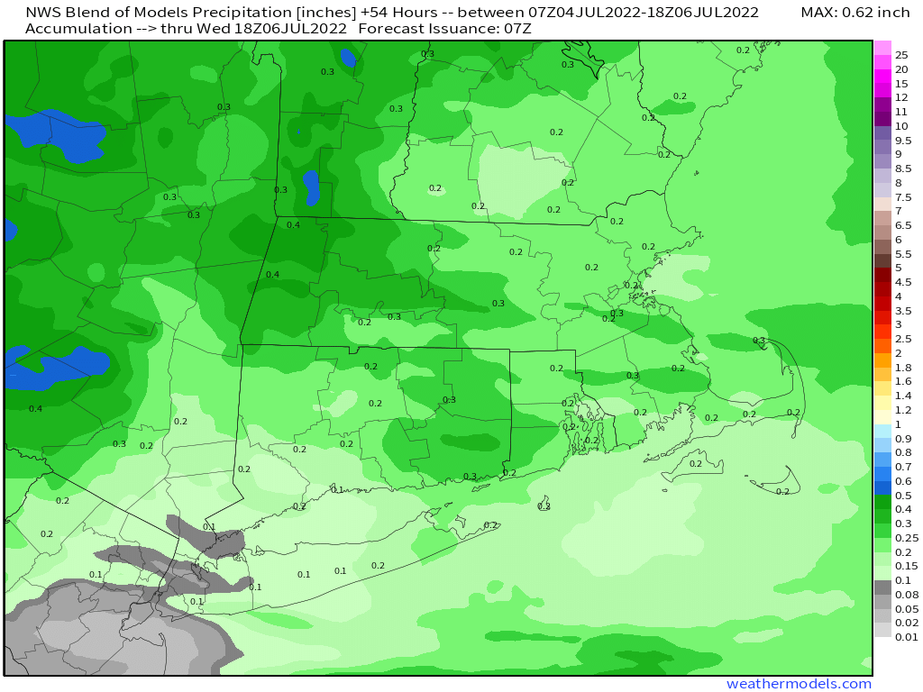
Friday is the uncertain day of the week. We’ll have a cold front crossing the region, likely producing some showers and thunderstorms. Temperatures will be determined by how quickly the front moves in, and how much cloudcover there is. The potential is there for much of the region to top 90 once again with muggy conditions. The next question is, how far south does the front get before stalling out. This will determine when we clear out on Saturday or the clouds linger along with the chance for more showers. Either way, temperatures should be cooler. High pressure should build in for Sunday with dry and seasonably warm conditions.

Friday could end up as another hot day across the region, but not all of the models agree. Images provided by Pivotal Weather.

Monday: Intervals of clouds and sun, chance for a few showers near the South Coast and across Cape Cod and the Islands. High 82-89.

Monday night: Partly cloudy. Low 64-71.

Tuesday: A mix of sun and clouds, a late-day shower or thunderstorm is possible. High 85-92.

Tuesday night: Clear to partly cloudy. Low 65-72.

Wednesday: Sunshine. Lots of sunshine. High 85-92.

Thursday: More sunshine. High 92-99, a little cooler near the South Coast.

Friday: Partly sunny, showers and thunderstorms possible during the afternoon and at night. High 86-93.

Saturday: A mix of sun and clouds, lingering showers possible in the morning. High 79-86.

Sunday: Partly sunny. High 85-92.

Weekend Outlook: July 29 – August 1, 2022

We really need some rain, and some of us will get a little, but not nearly enough, and for the most part, it shouldn’t impact your weekend plans.

Drought conditions are worsening across the region, and little improvement is expected for a while. Image provided by the National Drought Mitigation Center.

A few showers and thunderstorms are likely through this evening as a weak disturbance moves through, then skies may start to clear out a bit. Friday likely starts off with some sunshine, but a stronger front will be approaching. Another round of showers and thunderstorms is likely late Friday and into Friday night. Some models are showing the potential for the front to linger near the South Coast and keep the showers going through the night, but given the ongoing drought and recent trends, we’re not expecting a lot of rain, and it will likely be done before daybreak.

Some beneficial rain may fall in southern New Hampshire, but the rest of the region needs a lot more. Image provided by Weathermodels.com

High pressure builds in for the weekend and into Monday. This results in plenty of sunshine, warm temperatures, and fairly low dewpoints. In other words, nearly perfect weather for the end of July and start of August. There are some indications that heat and humidity will return next week, but we’ll worry about that in our Weekly Outlook early Monday.

Dewpoints will be in the 50s across much of the region Saturday afternoon. Image provided by WeatherBell.

Thursday night: Some showers or thunderstorms around in the evening, then becoming clear to partly cloudy. Low 64-71.

Friday: Morning sun, then clouds return with some showers and thunderstorms possible late in the day. High 84-91. Offshore: Southwest winds 10-15 knots, seas 2-3 feet, visibility 1-3 miles in late-day showers.

Friday night: Showers and thunderstorms during the evening, skies start to clear out late at night. Low 61-68.

Saturday: Plenty of sunshine. High 81-88. Offshore: West winds 5-10 knots, seas 2-4 feet.

Saturday night: Clear skies. Low 59-66.

Sunday: Sunshine and some afternoon clouds. High 82-89. Offshore: Southwest winds 10-15 knots, gusts to 20 knots, seas 2-3 feet.

Sunday night: Partly cloudy. Low 62-69.

Monday: Partly to mostly sunny. High 86-93. Offshore: Southwest winds 5-15 knots, seas 2-3 feet.

Weekly Outlook: July 25-31, 2022

The final week of July will not be as hot as last week was, but there will still be episodes of humidity to deal with.

After Sunday’s record-breaking heat, which topped 100 in places, today won’t be as hot with a cold front approaching the region. We’ll have plenty of cloud cover with some showers and thunderstorms expected ahead of the front. Some of the storms could be quite potent, with strong winds, hail, and heavy downpours. There is even a risk for a tornado. While the threat of severe weather exists from Maine to Virginia, around here, we think it’ll be mostly north and west of I-95 where the strongest storms occur, as usual. We could still see some strong storms in Rhode Island and southeastern Massachusetts, so don’t let your guard down if you’ll be in that neck of the woods during the afternoon.

Severe weather looks like a decent bet across the Northeast today. Image provided Pivotal Weather.

While temperatures will be “cooler” today they’ll still be in the 80s, possibly near 90 in spots if we can get enough sunshine in the morning. Of course, if we get some sunshine, that will also help to fuel some stronger thunderstorms. It’ll also be a much more humid day, with dewpoints well into the 60s and 70s, so it’ll feel nearly as hot as Sunday was. As a result, the National Weather Service extended the Heat Advisory for much of Eastern Massachusetts and Rhode Island until 5pm today.

It will feel like it is near or over 100 degrees early this afternoon across the region. Image provided by Weathermodels.com

The cold front moves offshore tonight, then high pressure builds in for Tuesday and Wednesday with drier conditions. Temperatures should still reach the 80s, but dewpoints will be in the 50s and lower 60s. The next system approaches on Thursday, so we’ll turn warmer and more humid once again, with some showers and thunderstorms likely late Thursday into Friday. At this time, it doesn’t look like the threat for severe weather is as significant as today, but it’s still a few days away, so we’ll keep monitoring things. High pressure builds back in next weekend with seasonably warm and drier weather once again.

Tuesday will be much more comfortable with dewpoints in the 50s and lower 60s. Image provided by WeatherBell.

Monday: Some morning sun, then becoming cloudy and breezy with showers and thunderstorms likely, some of which could be strong to severe. High 85-92.

Monday Night: Showers and thunderstorms end in the evening, then skies gradually clear out. Low 59-66.

Tuesday: A mix of sun and clouds, not as humid. High 80-87.

Tuesday night: Clear skies. Low 58-65.

Wednesday: Partly sunny. High 83-90.

Thursday: Becoming partly to mostly cloudy with showers and thunderstorms possible during the afternoon and evening. High 85-92.

Friday: Partly sunny with a chance of showers. High 82-89.

Saturday: Sunshine and some afternoon clouds. High 81-88.

Sunday: Partly to mostly sunny. High 82-89.

Weekend Outlook: July 22-25, 2022

Hot Hot Hot. Buster Poindexter’s song is also for the forecast for the next few days.

Showers and thunderstorms will end this evening as a frontal system pushes offshore, then skies clear out overnight. Drier air settles in for Friday and Saturday, with dewpoints in the 50s Friday and 60s Saturday, but it will remain hot, with temperatures well into the 90s in many locations. Sunday is shaping up to be a rather hot and humid day as another frontal system approaches the region. Temperatures should be well into the 90s again with high to oppressive humidity. Some models are showing the potential for triple-digit temperatures north and west of Boston, especially from the Merrimack Valley into southern New Hampshire. We’re not sure it gets quite that hot, but upper 90s are a distinct possibility. Some showers and thunderstorms are likely late Sunday night, and again on Monday as another frontal system crosses the region. Humidity levels will start dropping again later on Monday, but it will remain warm, with highs well into the 80s, and some places could top 90 once again.

Sunday is looking like a very hot day across much of the region. Image provided by WeatherBell.

If you’re curious about the record highs for Sunday and whether some could be broken, here are the current records for some selected cities across the region:

  • Blue Hill – 96 (1987)
  • Boston – 98 (1933)
  • Brockton – 97 (1987)
  • Concord, NH – 100 (1870)
  • Hyannis – 93 (1952)
  • Keene, NH – 95 (1910)
  • Lowell – 98 (1963 and 1987)
  • Manchester, NH – 95 (2001)
  • Nashua, NH – 100 (1952)
  • Newburyport – 96 (2002)
  • Portsmouth, NH – 95 (1987)
  • Providence, RI – 94 (1987)
  • Reading – 99 (2016)
  • Woonsocket, RI – 95 (2016)
  • Worcester – 94 (1910)

Thursday night: Showers and thunderstorms ending then skies clear out. Low 67-74.

Friday: Plenty of sunshine, not as humid. High 89-96, cooler right at the coast. Offshore: Small Craft Advisory for the South Coast. West winds 5-10 knots, becoming southwest 10-15 knots in the afternoon, seas 3-5 feet, a little higher off the South Coast, visibility under 1 mile in morning fog, improving in the afternoon.

Friday night: Clear skies. Low 66-73.

Saturday: Sunshine and a few clouds. High 89-96, cooler right at the coast. Offshore: Southwest 5-10 knots in the afternoon, seas 2-4 feet, visibility under 1 mile in morning fog, improving in the afternoon.

Saturday night: Clear to partly cloudy. Low 68-75.

Sunday: A mix of sun and clouds, humid. High 93-100. Offshore: Southwest winds 10-15 knots, gusting to 25 knots, seas 2-4 feet, visibility 10 miles or better.

Sunday night: Partly to mostly cloudy with some showers and thunderstorms possible. Low 70-77.

Monday: Intervals of clouds and sun with additional showers and thunderstorms, especially during the afternoon. High 84-91. Offshore: Small Craft Advisory likely. Southwest winds 10-20 knots, gusting to 25 knots, season 3-6 feet, visibility 1-3 miles in showers and thunderstorms.

Weekly Outlook: July 18-24, 2022

Hot weather is expected for much of the upcoming week (in July? That never happens!), but luckily, humidity levels won’t be that bad most of the time.

An approaching frontal system will bring in some showers and thunderstorms today into tonight. While we need any rain we get to help put a dent in the developing drought, it looks like the heaviest rain will stay north and west of the region. Still, some of the storms that do develop may contain some heavy downpours. Drier air settles in behind the front for Tuesday, but the airmass behind the front isn’t that cold, and in fact, with sunshine, temperatures will actually be warmer than today, making a run at 90 in many locations. Wednesday also looks hot, but with moderate humidity levels.

Most of the models keep the heavy rain out of eastern Massachusetts and Rhode Island today. Images provided by Pivotal Weather.

Thursday looks oppressive at this point with heat and humidity increasing as another frontal system approaches the region. That front may produce a few showers and thunderstorms late in the day, but for now, it doesn’t look like a widespread severe weather event is likely. Drier air settles in for Friday with hot weather continuing. Next weekend looks very warm to hot with moderate humidity levels and a few pop-up showers and thunderstorms, especially on Sunday.

The combination of heat and humidity will make it feel likely it’s close to 100 degrees Thursday afternoon. Image provided by WeatherBell.

Monday: Mostly cloudy with showers and thunderstorms developing. High 78-85.

Monday night: Showers and thunderstorms ending, some clearing late at night. Low 66-73.

Tuesday: Becoming mostly sunny and not as humid. High 85-92.

Tuesday night: Clear to partly cloudy. Low 67-74.

Wednesday: Sunshine and a few afternoon clouds. High 89-96.

Thursday: A mix of sun and clouds with some late-day showers and thunderstorms possible, humid. High 89-96, cooler along the South Coast.

Friday: Plenty of sunshine, not as humid. High 86-93.

Saturday: Partly to mostly sunny. High 87-94.

Sunday: Partly sunny with a few showers and thunderstorms during the afternoon. High 85-92.

Weekend Outlook: July 15-18, 2022

Despite a little rain early this morning, and some thunderstorms this afternoon, the drought continues to worsen around here, and we won’t get much relief over the next few days.

Parts of Northeastern Massachusetts and adjacent New Hampshire are now in a severe drought. Image provided by the National Drought Mitigation Center

We’ll have some showers and thunderstorms around this evening before a cold front pushes offshore. This allows drier air to settle in with high pressure for Friday and Saturday. Temperatures will remain on the warm side, but it won’t be humid. The humidity returns on Sunday as the high moves offshore and another frontal system approaches from the west. That front may trigger a few showers and thunderstorms late Sunday, but they likely hold off until Sunday night. Monday looks unsettled at this point as the front takes it’s time moving through, with more showers and thunderstorms likely. Some of the models are showing the potential for heavy rain at times on Monday, but given the way the models have performed in terms of rainfall, and the fact that we’re in a drought, we’re a bit skeptical on the idea of heavy rain for Monday. We’ll revisit that in our Weekly Outlook late Sunday night/early Monday morning.

Some models show the potential for heavy rain on Monday. We’re a bit skeptical. Images provided by Pivotal Weather.

Thursday night: Any lingering showers or thunderstorms end this evening, then skies clear out. Low 58-65.

Friday: Sunshine and a few clouds. High 79-86, coolest along the coast thanks to an afternoon seabreeze. Offshore: Northwest winds 5-10 knots becoming onshore in the afternoon, seas 2-4 feet, visibility under 1 mile in morning fog.

Friday night: Clear to partly cloudy. Low 59-66.

Saturday: A mix of sun and clouds. High 80-87. coolest along the coast. Offshore: South winds 5-10 knots, seas 2-3 feet, visibility 1-3 miles in some morning fog.

Saturday night: Partly cloudy. Low 63-70.

Sunday: Partly sunny, humid, chance for a late-day shower or thunderstorm. High 81-88. Offshore: Southwest winds 10-15 knots, gusts to 20 knots, seas 2-3 feet.

Sunday night: Partly to mostly cloudy with a few showers and thunderstorms around. Low 64-71.

Monday: Intervals of clouds and sunshine, with scattered showers and thunderstorms. High 81-88. Offshore: Southwest winds 10-15 knots, gusts to 25 knots, seas 2-4 feet, visibility 1-3 miles in showers.

Weekly Outlook: July 11-17, 2022

Much of the upcoming week will feature some weather that is rather typical for July.

High pressure moves offshore today, with southwest winds increasing this afternoon, bringing warmer, and more humid air into the region. You probably won’t notice the humidity until tonight, but you will certainly notice it on Tuesday, when hot and humid weather moves in ahead of a cold front. That front may produce showers and thunderstorms late in the day and at night. Right now, it looks like most of the severe weather should stay well to the west, but a few storms could produce some gusty winds and downpours Tuesday night. The front pushes offshore Wednesday morning, but it will remain quite warm, with humidity levels dropping during the day.

Tuesday looks to be a hot day, especially across the interior. Image provided by Pivotal Weather.

High pressure builds in for Thursday and Friday with seasonably warm and dry conditions. We’ll start to warm up and become more humid again on Saturday, then the next frontal system approaches on Sunday, with a chance for more showers and thunderstorms.

Very little rainfall is expected this week, with only 2 chances at some showers between now and Sunday. Image provided by WeatherBell.

Monday: Sunshine and a few clouds, breezy during the afternoon. High 82-89, a little cooler along the South Coast.

Monday night: Clear skies. Low 62-69.

Tuesday: Partly sunny, breezy, humid, chance for some late-day showers and thunderstorms. High 86-93, a little cooler along the South Coast.

Tuesday night: Partly cloudy, showers and thunderstorms possible, especially during the evening. Low 63-70.

Wednesday: Becoming mostly sunny. High 85-92.

Thursday: Partly sunny. High 81-88.

Friday: A mix of sun and clouds. High 78-85.

Saturday: Intervals of sun and clouds. High 81-88.

Sunday: Partly sunny, humid, chance for a shower or thunderstorm. High 82-89.

Weekend Outlook: July 8-11, 2022

The weather for the upcoming weekend will be nearly perfect.

Sunshine will be dimmed by a few clouds today as high pressure slides offshore. Clouds will increase tonight as a warm front tries to approach the region. Humidity levels will increase tomorrow ahead of a cold front, but aside from a few hit-or-miss showers, the front will move through late in the day with little fanfare. After that, high pressure builds in for the weekend with sunshine, temperatures that are near or a little below normal for early July, and low humidity levels. Monday looks to be similar, but as the high moves offshore, temperatures and humidity levels will start to rise a little.

Dewpoints in the upper 40s and lower 50s in July? Enjoy the refreshing air this weekend! Image provided by WeatherBell.

Thursday night: Partly to mostly cloudy. Low 58-65.

Friday: Intervals of clouds and sunshine with a chance for a few showers. High 80-87. Offshore: South to southeast winds 5-10 knots, seas 2-3 feet.

Friday night: Becoming partly cloudy. Low 60-67.

Saturday: Sunshine and a few clouds. High 76-83, a little cooler along the coast. Offshore: Northeast to east winds 5-10 knots, seas 2-3 feet.

Saturday night: Clear skies. Low 53-60.

Sunday: Plenty of sunshine. High 75-82, a little cooler along the coast. Offshore: Southwest winds 10-15 knots, gusts to 25 knots, seas 2-4 feet.

Sunday night: Clear skies. Low 54-61.

Monday: Sunshine and some afternoon clouds. High 81-88. Offshore: South to southwest winds 10-15 knots, gusts to 20 knots, seas 2-4 feet.

Weekly Outlook: July 4-10, 2022

As is typical of summer, we’ve got a fairly uneventful week coming up across the region.

High pressure remains in control today with sunshine, warm temperatures and comfortable humidity. As the high moves offshore, a weak system will head towards northern New England. Clouds will start to move in Monday night, but they’ll start to thicken up Tuesday afternoon, with a round of showers and thunderstorms expected late Tuesday afternoon and Tuesday night. High pressure builds back in for Wednesday through Friday with dry and seasonably warm conditions. Another system will bring in a few showers and thunderstorms late Friday or Saturday, then high pressure builds back in for Sunday.

Some beneficial rain is likely Tuesday night, but we need a lot more to help alleviate the drought. Image provided by Weathermodels.com

Monday: Sunshine and some late-day clouds. High 78-85.

Monday night: Partly cloudy. Low 59-66.

Tuesday: Some morning sun, then becoming mostly cloudy and breezy, showers possible late in the day. High 81-88.

Tuesday night: Mostly cloudy with showers likely, ending late at night. Low 64-71.

Wednesday: Becoming mostly sunny. High 78-85.

Thursday: A mix of sun and clouds. High 77-84.

Friday: Partly sunny with a chance for showers late in the day and at night. High 78-85.

Saturday: Partly sunny, chance for a few showers, mainly early. High 74-81.

Sunday: Mostly sunny. High 75-82.