Yup, you read that headline right. October is just about here. Baseball hits the postseason, football is in full swing, hockey is starting up, the leaves are starting to change colors, and pumpkin everything is in the stores. Within the next few days you’ll probably start to see Christmas stuff showing up as well if you haven’t already.
As September ends and October begins, what type of weather do you normally think of? Record heat, right? You thought we were talking about something different, didn’t you? That’ll come soon enough. For now, enjoy the summer-like temperatures, they’ll be here for the next several days, thanks to a large area of high pressure.
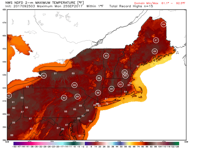
Record high temperatures are possible for many locations across the Northeast today. Image provided by WeatherBell.
Not only is that high pressure area going to keep us dry and warm, it’s going to block Hurricane Maria from coming up the coast (more on Maria in a bit). Alas, all good things must come to an end, and in this case, a cold front is responsible. It will produce a few showers, maybe even a thunderstorm, for late Wednesday and more likely Thursday. One thing we will need to keep an eye on, is if the cold front interacts with Maria when it is well offshore. If it does interact with Maria, it could result in a period of heavy rain. Right now, if this were to occur, it would most likely be either offshore or over Atlantic Canada, but there is a chance it could happen closer to us, especially Cape Cod. High pressure then builds in behind the front for Friday and the weekend with much cooler conditions. It will likely be drier as well, but that’s not set in stone yet. Some of the models show a weak disturbance moving through on Saturday that could produce some showers, while other models have that disturbance slide off to our south. We’re leaning towards the drier solution for now, but confidence is a little less than normal.
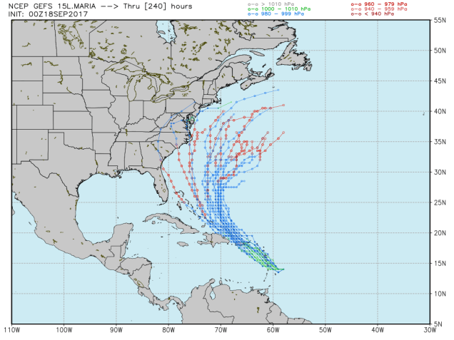
Model forecasts for the track of Hurricane Maria. Another landfall is not expected. Image provided by the University of Wisconsin-Madison.
As for the tropics, we’ve got two hurricanes in the Atlantic right now, Lee and Maria. After blasting the Leeward Islands, Virgin Islands, and Puerto Rico earlier in the week as a Category 4-5 Hurricane, Maria has weakened considerably, and is now a Category 1 storm with maximum sustained winds near 90 mph. As of early Monday morning Maria was centered about 375 miles south-southeast of Cape Hatteras, North Carolina, moving toward the north at 8 mph. A Tropical Storm Watch is in effect from Surf City, North Carolina northward to the Virginia border, including Albemarle and Pamlico Sounds. Maria should continue northward for the next couple of days while slowly weakening, passing east of the Outer Banks of North Carolina, but close enough for some gusty winds and rainfall to impact the region. By mid-week, Maria will encounter strong westerly winds and upper levels, which will make the storm take a big right turn, and head out to sea.
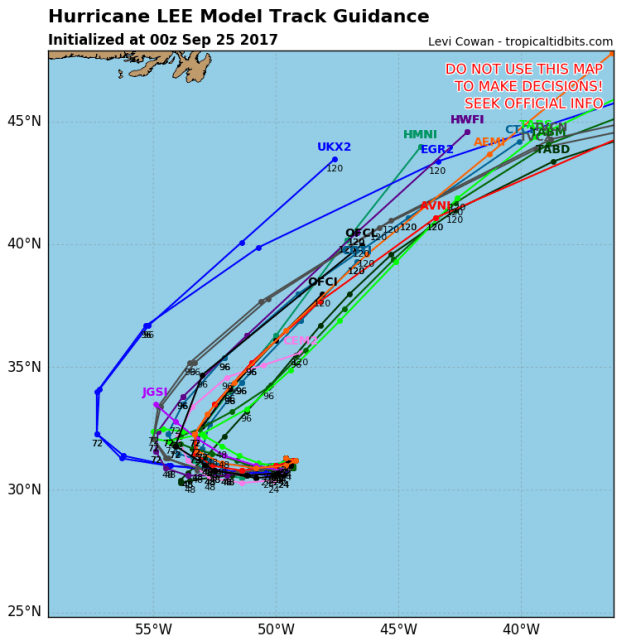
Model forecasts for the track of Hurricane Lee. This will be another “fish storm”. Image provided by Tropical Tidbits.
Meanwhile, Hurricane Lee also has maximum sustained winds near 90 mph, and is centered about 900 miles east of Bermuda, drifting toward the east-southeast at 3 mph. Lee may strengthen a bit over the next day or two while turning more towards the west. Eventually, a turn more towards the north and northeast is expected, keeping the storm over open waters for its entire lifespan.
Monday: Some patchy fog early, otherwise partly to mostly sunny. High 82-89, cooler right along the coast.
Monday night: Clear to partly cloudy. Low 60-67.
Tuesday: Sunshine filtered through some high clouds. High 80-87.
Tuesday night: Clear to partly cloudy. Low 61-68.
Wednesday: A mix of sun and clouds, chance for a few showers. High 78-85.
Thursday: Chance for showers early, then skies clear out in the afternoon. High 73-80.
Friday: Sunshine and a few clouds. High 63-70.
Saturday: Partly sunny, slight chance for a few showers. High 61-68.
Ready for another quiet week weather-wise? You must be in San Diego then, because this week certainly won’t be quiet around here.
The week starts off with high pressure over Atlantic Canada. The southeast to south flow around this high pressure area will keep plenty of moisture in place, resulting in some dense fog to start the day in parts of the region. The fog will burn off, but clouds will dominate the day with only a few sunny breaks as some of the moisture from Jose streams northward into the region. That brings us to Jose, and what it will do.
Model forecasts for the track of Hurricane Jose. Could it make another loop, this time south of New England? Time will tell. Image provided by Tropical Tidbits.
A Tropical Storm Watch is in effect for the East Coast from Fenwick Island, Delaware, northward to Plymouth, Massachusetts. Although Jose remains a hurricane now, it will weaken to a tropical storm as it heads northward in between Bermuda and the East Coast. Although there are still a few forecast models that bring the center of the storm very close to, if not right across, the south coast of New England, the more likely scenario is for the storm to make a right turn, and pass south and east of the area. It will still be close enough to spread in some locally heavy rain, with gusty winds along the coast as well. As we talked about in our blog post on Saturday, this is basically a “nor’easter with a name.” The rain will move into the region on Tuesday, with the heaviest rain and strongest winds likely Tuesday night into Wednesday, mainly across southeastern Massachusetts and Cape Cod. There will still be some locally heavier showers farther inland, and winds may occasionally be gusty, with the biggest impact from the storm will basically be south and east of I-95. Along the coast, we may also have to deal with some coastal flooding, as the persistent east to northeast winds will create some big waves, plus tides are running high this week thanks to a New Moon on Wednesday. Despite all of this, this storm is not going to be anything remotely resembling Harvey or Irma. We have said this a few times already, but we’ll say it again, just because it has a name, does not make it that big of a deal. We get storms that hit us harder nearly every fall and winter.
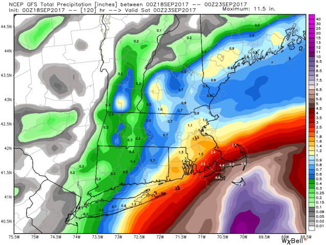
GFS model forecast for rainfall through Friday evening. Most areas north and west of Boston would receive an inch or less, with the heaviest amounts confined to Cape Cod if this forecast verifies. Image provided by WeatherBell.
Thursday and Friday are where things start to get to tricky around here. The trend in the models for the past few runs has been for the storm to slow down and slowly turn back toward the south once it gets past us. Given that the storm will be even weaker by then as it sits over the colder waters off of the coast, winds won’t be much of an issue, except across the Cape and Islands. However, if the storm does slow down or even stall, it will keep the clouds locked in for Thursday and Friday, as well as the threat for more rain, mainly across the Cape and southeastern Massachusetts. Of course, if the storm slows down or makes the turn a little farther away than currently expected, then we may see some improving conditions. No matter what happens Thursday and Friday, by next weekend, the storm pulls far enough away to allow high pressure to build back in with sunshine returning to the entire region.
Next Sunday could be quite a warm late-September afternoon if you believe the GFS. We’re not forecasting temperatures quite this warm, but it is certainly possible. Image provided by Pivotal Weather.
Monday: Some patchy dense fog early, otherwise plenty of clouds with a few sunny breaks. A shower or two can’t be ruled out. High 69-76.
Monday night: Cloudy and becoming breezy with rain developing along the South Coast after midnight, gradually spreading northward. Low 59-66.
Tuesday: Windy along the coast, breezy elsewhere with periods of rain and showers, possibly heavy at times along the South Coast and across the Cape. High 64-71.
Tuesday night: Windy, especially along the coast, with periods of rain, heavy at times, especially south of Boston. Low 60-67.
Wednesday: Windy along the coast, breezy elsewhere with periods of rain and showers, heavy at times along the South Coast and across the Cape. High 65-72.
Thursday: Mostly cloudy, still breezy across the Cape. Chance for more rain and showers, mainly across Cape Cod and southeastern Massachusetts. High 63-70 along the coast and south of Boston, 70-77 elsewhere.
Friday: Plenty of clouds with some sunny breaks, especially north and west of Boston. Some additional showers are still possible across Cape Cod. High 61-68 along the coast and south of Boston, 68-75 elsewhere.
Saturday: Becoming partly to mostly sunny, though clouds may be slow to move out across Cape Cod. High 74-81, cooler along the coast and across Cape Cod.
Sunday: Plenty of sunshine. High 78-85.
Hurricane Maria continues to strengthen while approaching the Leeward Islands. Loop provided by NOAA.
Finally, we’ll talk about Hurricane Maria. Maria will move across the Leeward Islands today, a little south of where Irma went across. As of early Monday morning, Maria had maximum sustained winds of 90 mph, and more strengthening is expected. Maria could become a Category 3 hurricane before crossing the islands. Once it crosses the Leeward Islands, it will turn a bit more toward the northwest. On this track, it will likely pass very close to St. Croix, and near or across Puerto Rico., possibly as a Category 3 or 4 Hurricane While St. Croix fared better than most of the other Virgin Islands during Irma, this is a region that does not need another major storm moving through. Once it gets past Puerto Rico and the Virgin Islands, there is a chance it could threaten the East Coast. Any potential impacts would be at least a week away at this point, so it’s not worth worrying about for now. However, we figured it was at least worth mentioning that after Jose passes by, not to let your guard down. We’ll keep tabs on Maria’s progress, and if the threat does materialize, we’ll let you know.
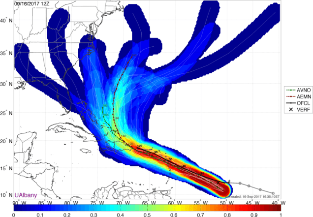
Track forecasts for Maria from the various members of the GFS Ensemble. Image provided by WeatherBell.
We’ve got a nor’easter with a name heading our way, but the bigger story will be unfolding in the Caribbean over the next few days, as yet another hurricane takes aim on the islands.
From left to right: Hurricane Jose, Tropical Storm Maria, and Tropical Storm Lee. Loop provided by NOAA.
With Irma dissipating over land a few days ago, Jose was the only active tropical system in the Atlantic for a few days, and thus grabbed most of the attention while it did a little loop a few hundred miles east of the Bahamas. It weakened to a tropical storm, but has since become a hurricane again. As of 5pm Saturday, it was centered a little less than 500 miles south-southeast of Cape Hatteras, NC with maximum sustained winds near 80 mph. It was moving towards the north at about 6 mph. The forecast for Jose for the next 48 hours is fairly easy. It will continue to head northward around the edge of a large high pressure area. While it remains over very warm water, there is still plenty of wind shear aloft, and the wind shear will counteract the warm water, preventing much, if any, additional intensification. It will produce rough seas for much of the western Atlantic, and also create a high risk of rip currents from New England to the Carolinas.
Jose will will produce rough seas and rip currents across much of the East Coast over the next few days. Image provided by WeatherBell.
By Tuesday, Jose will start to move over colder waters as it passes north of the Gulf Stream, so it should start to weaken. At the same time, it will start to encounter westerly winds aloft, which will turn it more towards the northeast and eventually east. On this track, the center should pass about 100 to 150 miles south and east of Cape Cod as a weakening tropical storm. By this point, the storm may not even be completely tropical any more, and starting the transition into an extratropical system. It will pass close enough to bring gusty winds and some rainfall into southeastern portions of New England, but the impacts will be similar to a fall nor’easter, with temperatures in the 60s not the 40s (or colder). The biggest impacts will be across Cape Cod, where some wind gusts in excess of 60 mph are possible. Coastal flooding will also be an issue, as tides are running high this week with the New Moon on Wednesday. Rainfall totals of 1-3 inches and locally heavier shouldn’t cause any flooding issues, and will actually be beneficial, as some parts of the region have been dry lately, with some drought conditions starting to reappear. In other words, don’t freak out, we’ll probably have worse storms to deal with later this fall or winter, especially since many of those will have the dreaded s-word involved.
Model forecast for the track of Hurricane Jose. Landfall is not expected Image provided by TropicalTidbits.
Well out in the Atlantic is Tropical Storm Lee. As of 5pm Saturday, Lee was centered about 720 miles west-southwest of the Cape Verde Islands, moving towards the west at 10 mph. Lee has maximum sustained winds near 40 mph. Lee is expected to continue on a general west to west-northwest track for the next few days. While some modest strengthening is possible over the next day or two, the long-term outlook is for Lee to weaken by early next week, and probably dissipate over the open waters of the central Atlantic, well away from any land areas.
Forecast track for Tropical Storm Lee. Yawn. Image provided by the National Hurricane Center.
While Jose has been grabbing the headlines, and Lee remains weak, Tropical Storm Maria has formed east of the Lesser Antilles, and this storm will likely grab most of the attention over the next few days, especially after Jose starts to move away from the East Coast.
Tropical Storm Maria formed Saturday afternoon east of the Lesser Antilles. As of 5pm Saturday, it was centered about 620 miles east-southeast of the Lesser Antilles, moving towards the west at 20 mph. Maximum sustained winds are near 50 mph, and additional strengthening is expected. Maria could become a hurricane on Sunday. A hurricane watch has already been issued for the islands of Antigua, Barbuda, St. Kitts, Nevis, and Montserrat, with a tropical storm watch in effect for the islands of St. Lucia, Martinique, Guadeloupe, Dominica, Barbados, St. Vincent, and the Grenadines. Additional watches and warnings are likely to be issued tonight and Sunday.
Model forecasts for the track of Tropical Storm Maria. This is going to be a problem for some of the islands. Image provided by the University of Wisconsin-Madison.
Maria is expected to cross the Lesser Antilles as a hurricane on Monday. It should pass farther south than Irma, which will spare the islands that were devastated from another direct hit. Once it gets past the Antilles, it will turn more towards the northwest, and head towards the Virgin Islands and Puerto Rico for Tuesday into Wednesday. It could become a strong hurricane by this point, so residents on this region, still trying to cleanup after Irma, need to play close attention to Maria. While Irma delivered a heavy blow to much of the British and US Virgin Islands, it did not do as much damage on St. Croix, the southernmost and largest island of the chain. If Maria does in fact track farther south than Irma did, then St. Croix could conceivably get hit harder than the rest of the Virgin Islands. This will be something to pay attention to in the next few days.
GFS Ensemble forecast for the track of Tropical Storm Maria. Image provided by the University at Albany.
What about Maria’s future beyond mid-week? Well, at this point, almost anything is possible. As you can see from the GFS Ensemble plot above, it could continue northwestward towards Florida, turn more toward the north and potentially be a threat to the East Coast, or turn more towards the northeast and head out to sea. We won’t have a better idea about that until the middle of the upcoming week, if not later. To quote a friend of the blog when asked about Maria’s future:
“It’s way, way, way too early to even conjecture on that. Let’s just say, given the pattern, that folks on the East Coast shouldn’t just hit the snooze button once Jose departs.”
That’s probably the best advice we could give you right now as well.
Mid-September is the peak of hurricane season in the Atlantic, and although things seemed a bit more quiet after Irma finally dissipated, that’s about to change again. We’ve got two active tropical systems in the Atlantic right now, and possibly a third one on the way. Bond villain Elliot Carver’s line from “Tomorrow Never Dies” seemed appropriate tonight.
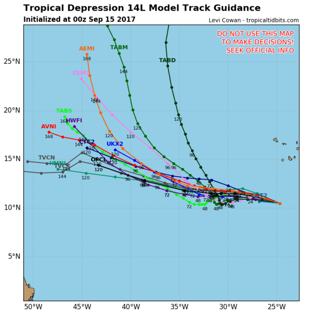
Tropical Depression 14 will wreak havoc on the fish in the Central Atlantic for the next several days, but not much else. Image provided by Tropical Tidbits.
We’ll start by talking about newly-formed Tropical Depression 14. (We’re saving the best for last – we’ve got to keep you reading somehow). It developed late Thursday evening about 380 miles south-southwest of the Cape Verde Islands. It’s got maximum sustained winds near 35 mph, and is scooting along towards the west-northwest at 22 mph. The system is expected to strengthen into a tropical storm over the next day or so, and could even become a hurricane this weekend. A general west-northwest to northwest track is expected for the next 3-5 days, before it turns more toward the north-northwest. Meteorologists like to refer to a storm like this as a “fish storm”, because aside from the fish, it won’t really impact anyone else.
A disturbance in the Atlantic could become a tropical depression by early next week, and could threaten the Lesser Antilles. Or maybe it won’t. We’ll wait and see. Image provided by WeatherBell.
Another disturbance is located in the Central Atlantic, about 1200 miles east-southeast of the Lesser Antilles early this morning. (Don’t worry, we’re getting to the good part). Right now, it’s just a poorly organized cluster of thunderstorms, but conditions are favorable for it to become more organized over the next few days. It could become a tropical depression or a tropical storm by early next week. Right now, it looks like it could take a track towards the Lesser Antilles, but this is far from a given at the moment. Let’s wait to see if it even forms first, then we’ll worry about where it’s going.
Finally, we get to Tropical Storm Jose. You may remember earlier this week, when Jose was a Category 4 storm, and looked like it was going to hammer some of the same islands that Irma wiped out a week ago. Well, it turned just in time, sparing those islands for the most part. Jose then stalled out north of Puerto Rico and made an anti-cyclonic loop. Since it was sitting over the same general area of several days, it churned up the water pretty good, bringing the much cooler water down below to the top, and dispersing the warmer water that was there. This is called “upwelling.” Since tropical systems need to be over warm water to maintain their strength, when they sit for too long in the same location, they tend to weaken. Jose weakened from a storm that was on the cusp of Category 5 status with maximum sustained winds near 155 mph last Friday, to a tropical storm with 70 mph winds early this morning.
Jose is likely to start moving towards the west and eventually northwest over the next few days. This will bring the storm back over warmer waters, and also move it away from the wind shear that has been tearing it apart, which will allow it to strengthen into a hurricane again. A large ridge of high pressure is in place across the Atlantic, and that will help to steer Jose through the weekend. Jose will move around the edge of the ridge, heading towards the northwest and eventually north, likely as a hurricane, this weekend. Since it’s been sitting over the open ocean for a while and will start heading towards the west and northwest, it will send some large swells towards the Bahamas, Bermuda, and the East Coast.
Jose will generate large swells for most of the East Coast by Sunday. Image provided by WeatherBell.
Once we get past the weekend, things get complicated. As you may recall, in our Weekly Outlook on Monday, we mentioned that a few of the models showed a potential threat from Jose next week, but that the threat was very low. Well, it’s not quite so low any more. If you had asked us on Monday what the odds were of a direct impact, we’d have probably said 1 in 50, or about 2%. Now? We’ll call it 1 in 6, or about 15%. In other words, it’s still a low threat, but it’s certainly gotten our attention now. If you live near the South Coast or Cape Cod, it should probably have your attention too. So what has changed? Most of the models have shifted westward with their tracks for Jose over the past few days. As you may recall, a similar shift occurred with Irma. Many models kept trying to bring Irma up the East Coast, and even a day or two before landfall, many of them showed a track up the east side of Florida and into the Carolinas. With this westward shift, the models now bring the storm much closer to the East Coast. There are still plenty of them that keep it well offshore. Others keep it offshore, but close enough to bring some rain and strong winds into parts of southeastern New England. A few models bring the storm right across the region, likely in a much-weakened state. Then there’s a couple of models that are just completely insane. One model has Jose hit New England as a weak hurricane, move offshore, loop around, then try to come back again as a weak nor’easter a couple of days later. What it does beyond that is even more insane, which is why we’re ignoring that model completely.
Track forecasts for Jose from the ECMWF Ensemble, the more yellows and reds, the more agreement there is among the members of the model. Image provided by the University at Albany.
Track forecasts for Jose from the CMC Ensemble, the more yellows and reds, the more agreement there is among the members of the model. Image provided by the University at Albany.
Track forecasts for Jose from the GFS Ensemble, the more yellows and reds, the more agreement there is among the members of the model. Image provided by the University at Albany.
The timing on when this could possibly impact our area would be around Tuesday or Wednesday of next week. Obviously, things can and will change between now and then. We’ll keep a close eye on it. We’ll obviously detail it in our Weekly Outlook Monday morning, but if the threat increases more, we may have another blog post this weekend about the storm.
For those interested, the Atlantic isn’t the only active area right now. Tropical Storm Norma could become a hurricane before heading towards Mexico’s Baja peninsula. Tropical Depression 15-E could become a tropical storm but remain over open waters in the Eastern Pacific. Typhoon Doksuri is making landfall in Vietnam, and Typhoon Talim will make landfall in southwestern Japan this weekend. Yeah, things are a little busy right now.
While Irma continues to plow further into Florida and Jose spends some quality time over the open Atlantic, we’ve got a nice quiet week on our hands, thanks to a large area of high pressure. Not only will it be quiet, it’ll be warm too.
Radar loop showing Irma’s progress northward across Florida after landfall. Loop provided by the College of DuPage.
First, we’ll talk about the tropics. Irma continues to move northward across central Florida while weakening early this morning. Irma will weaken to a tropical storm during the day on Monday while turning more towards the northwest. The center of Irma should move across southern Georgia, and then up towards the Tennessee Valley, where it will likely dissipate towards the middle of the week. Winds will still be a major problem across Florida today, especially central and northern Florida, but the bigger threat will shift to rainfall as we head through the day and into mid-week. Additional rainfall totals of 6-12 inches or more are expected across northern Florida and southern Georgia, with 2-6 inches possible from the Tennessee Valley into parts of the Carolinas. This will likely lead to flooding in some areas. While some of this moisture will stream up here in the form of clouds, only a few showers are possible, as high pressure keeps the rain bottled up to our south.
Heavy rain will likely lead to flooding across the Southeast over the next few days thanks to Irma. Image provided by WeatherBell.
We also are keeping an eye on Hurricane Jose. Early this morning, Jose was a few hundred miles east of the southern Bahamas with top winds near 100 mph. Jose will likely weaken a bit, and stall out or move very erratically for the next few days. As we get towards midweek, Jose may start to strengthen again while turning back towards the west, before eventually turning northward. While it is possible that Jose could be a threat to the East Coast, sometime next weekend or early in the following week, that threat is fairly low at this point. Yes, a couple of the computer models have shown a rather strong Hurricane Jose heading right up the East Coast around 10-12 days from now, but those models have problems picking out where things will be 3 days from now, never mind 10 days from now. In fact, 10 days ago, some of those exact same models showed Irma making landfall in New England. They were only off by over 1000 miles. In other words, despite seeing people post scary looking maps on Facebook and Twitter and telling you to start preparing now because New England could be next, we wouldn’t worry too much about it. If there is going to be a threat, we’ll let you know well in advance.
Despite what you may have seen on the Internet, Hurricane Jose is not a threat to any land areas over the next 5-7 days, except possibly the Bahamas. Beyond that, there is a low threat to the East Coast, but a track out to sea is still more likely. Image provided by the University at Albany.
As for our actual forecast, well, that’s pretty easy. High pressure keeps us warm and dry through at least Thursday. A weak front may try to drop down into the region with some cooler conditions and possibly a few showers late in the week. Next weekend looks cooler, but likely still dry, as high pressure tries to build back into the region.
Tuesday is looking like the pick of the week with sunshine and temperatures in the 80s. Normal highs for mid-September are in the middle 70s. Image provided by WeatherBell.
Monday: Plenty of sunshine. High 75-82.
Monday night: Clear to partly cloudy. Low 52-59.
Tuesday: Mostly sunny. High 80-87.
Tuesday night: Clear skies. Low 55-62.
Wednesday: Sunshine and some high clouds. High 78-85.
Thursday: A mix of sun and clouds. High 78-85.
Friday: Intervals of clouds and sunshine with some showers possible. High 73-80, possibly cooler right along the coast, especially in the afternoon.
Saturday: Partly sunny, slight chance for a shower. High 69-76.
Sunday: Partly to mostly sunny. High 73-80.
Temperatures will top 90 in parts of Montana today. By the end of the week, it could be snowing there. Yup, it’s getting to be that time of year. Image provided by Pivotal Weather.
We all know that Hollywood ran out of original ideas years ago, which is one of the main reasons that a lot of people don’t go to the movies much anymore. However, the past 2 weeks (and the upcoming week) are an epic disaster straight out of the Hollywood of yesteryear, except worse.
Satellite loop showing from left to right, Hurricanes Katia, Irma, and Jose. Loop provided by NOAA.
If this were the plot of a movie, would you go see it?
A tropical storm in the Gulf of Mexico blows up to a Category 4 hurricane and makes landfall, creating widespread damage along the Texas coast. Then, we stall the storm, have it sit there for days, and drop upwards of 4 feet of rain on Texas, resulting in some of the worst flooding ever seen. Just to make it worse, we’ll have the flooding centered around Houston, the 4th largest city in the nation. Then, after sitting there for a few days, we’ll have it go back into the Gulf of Mexico, strengthen a little, and head northward, making landfall again in Louisiana, dumping 1-3 feet of rain on that state and nearby parts of Texas that just barely missed out on the first batch. As that storm moves inland and finally dissipates, we’ll have another storm form way out in the Atlantic. That storm will grow into a beast – one of the strongest storms ever observed in the Atlantic. It head towards the islands in the Caribbean, and lay waste to a few of them, destroying pretty much everything in its path as it shatters records for strength and intensity. Then, after crossing the Bahamas, it’ll take aim at Florida, going on a near-worst-case scenario track for the entire state. It’ll make landfall in southern Florida as a Category 4 or 5 storm, and head due north, bringing hurricane conditions to pretty much the entire state, except maybe the Panhandle. Not only that, but we’ll have the worst conditions, the ones in the eyewall, pass right over heavily-populated Miami and Fort Lauderdale. While everyone is paying attention to the massive storm heading for Florida, we’ll have not one, but TWO more hurricanes develop, one in the Atlantic and another one in the Gulf. For the one in the Atlantic, we’ll have it blow up into a Category 4 storm, and then head right towards the same islands that just got wiped out 2 days earlier by the first storm. For the one in the Gulf, we’ll have it head towards Mexico. But wait, that’s not enough. While the folks in Mexico are preparing for a hurricane, we’ll have an 8.2 magnitude earthquake nearby, the strongest quake to impact Mexico in 100 years.
That’s the basic script, except it’s not a Hollywood creation, it’s the real thing. So, let’s get right to the details.
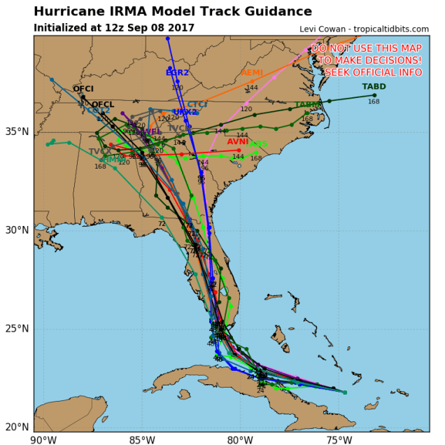
Computer model forecasts for the track of Irma. Image provided by Tropical Tidbits.
As of early Friday afternoon, Hurricane Irma was a Category 4 hurricane with maximum sustained winds near 155 mph. It was centered about 380 miles southeast of Miami, moving towards the west at 14 mph. Hurricane Warnings and Storm Surge Warnings are in effect for most of central and southern Florida, as well as the Bahamas and Cuba, with Hurricane Watches for much of northern Florida. Don’t let the fact that Irma has weakened to a Category 4 fool you. This is still a powerful storm, and its intensity will fluctuate for the next 24-36 hours. It could very easily regain Category 5 status, and will likely make landfall in Florida as a Category 4 or 5 storm.
Irma will continue on a general west-northwest track today, as it moves around the southern edge of a ridge of high pressure. At some point in the next day or so, it’ll reach the southwestern edge of that ridge and make a sharp right turn. Exactly when that turn occurs is key to landfall. Right now, it looks it’ll move across the Upper or Middle Keys, and then make landfall in extreme southwestern Florida Sunday morning. The good news is that this is where the Everglades are, and very few people live there. The bad news is that since it’s mostly the Everglades, the storm surge may penetrate very far inland. That’s not the end of the bad news though. The current track brings the storm virtually due northward, which means that for Sunday into early Monday, the storm will head right up the middle of Florida. Yes it’ll be weakening, but should maintain hurricane strength until it gets close to the Florida/Georgia border. That means, hurricane conditions for much of the state, except possibly the Panhandle. Wait, it gets worse. The worst conditions will be in the eyewall, just to the right of the center. With the storm heading northward, that means east of the center. Where will that eyewall be Sunday morning? Right over downtown Miami and Fort Lauderdale. When Hurricane Andrew hit the region 25 years ago, it was a tiny storm. Even though it wiped out communities just south of Miami, downtown itself was largely spared, and Fort Lauderdale fared even better. That will not likely be the case this time, as Irma is considerably larger. Even places farther to the north, such as Orlando, may see wind gusts upwards of 90 mph. The theme park itself has been closed for a while now, but much of central Florida will get to experience “Wet n’ Wild” once again. While flooding won’t be on the scale of Harvey, rainfall totals of 8-16 inches and locally heavier are possible across Florida, which will lead to some flooding problems.
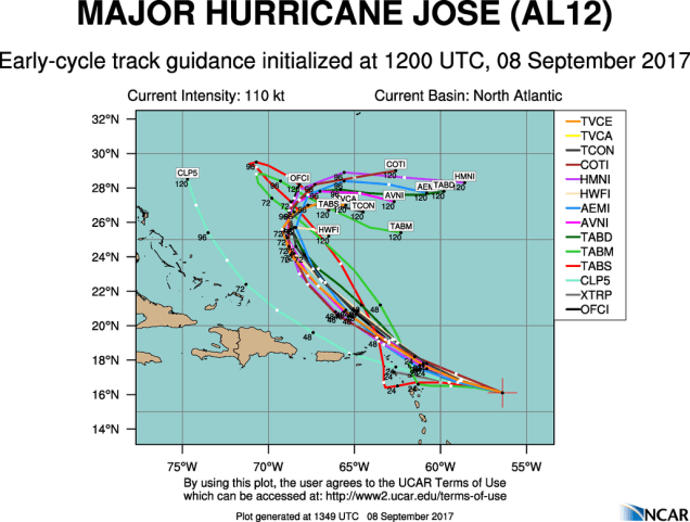
Model forecasts for the track of Hurricane Jose. Image provided by the National Center for Atmospheric Research.
While all attention has been focused on Irma, Hurricane Jose has blown up into a Category 4 hurricane in the Atlantic. As of early Friday afternoon, Jose was centered a little more than 380 miles east-southeast of the Northern Leeward Islands, moving toward the west-northwest at 18 mph. Maximum sustained winds are near 150 mph, and some fluctuations in intensity are expected for the next day or two. Jose should continue towards the west-northwest for another day or so before turning more towards the northwest. Unfortunately, that track will bring Jose very close to the islands in the northern Leeward Islands. These are the same islands that Irma just devastated a couple of days ago. Hurricane Watches have been posted for many of these islands, with Tropical Storm Watches farther south and west. The Tropical Storm Watches do not indicate that weakening is expected. They just show that those islands should be far enough from the center that they will “only” receive tropical storm conditions, and not hurricane conditions. Once Jose gets past the islands, things get a little more murky. Jose should head into the open Atlantic and start to weaken, but it will also slow down, and perhaps stall as high pressure builds in to its north. By the middle of next week, there is plenty of disagreement among the models as to where Jose will go. Some models have the high pressure area retreating, which will allow Jose to head back into the open Atlantic. Others have the high pressure area strengthening, which would send Jose westward, towards the Bahamas and possibly the East Coast. It is WAY too early to figure out which solution is more plausible at this point. So, we may be dealing with Jose at some point again next week.
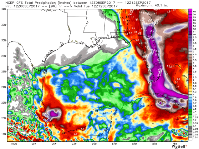
GFS model forecast for rainfall across the Gulf of Mexico over the next 4 days. Irma will produce torrential rainfall across Florida, while the smaller Katia will bring heavy rain to parts of Mexico. Image provided by WeatherBell.
Wait, don’t stop reading now! We’ve got even more to talk about! In the Gulf of Mexico we have Hurricane Katia! As of midday Friday, Katia was centered about 125 miles north-northeast of Veracruz, Mexico, drifting toward the west-southwest at 5 mph. Katia is a Category 2 Hurricane, with top winds near 100 mph. Hurricane Warnings are in effect for parts of the Mexican coastline. Katia should make landfall tonight, then rapidly weaken once moving inland, as it encounters the mountainous terrain of Mexico. While this will keep wind damage confined to coastal areas, it makes the threat of flooding and mudslides even worse. Rainfall totals of 10-20 inches and locally heavier are likely in this area over the next few days.
Oh, and if that’s not enough, another tropical wave will emerge from the coast of Africa this weekend. Several computer models show the potential for that system to develop as it moves across the Atlantic next week. So, the suddenly active Hurricane Season of 2017 will likely roll on well into September.
While Hurricane Irma is rightfully grabbing all the attention, there are two other tropical storms that could be threats to land in the coming days.
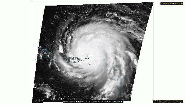
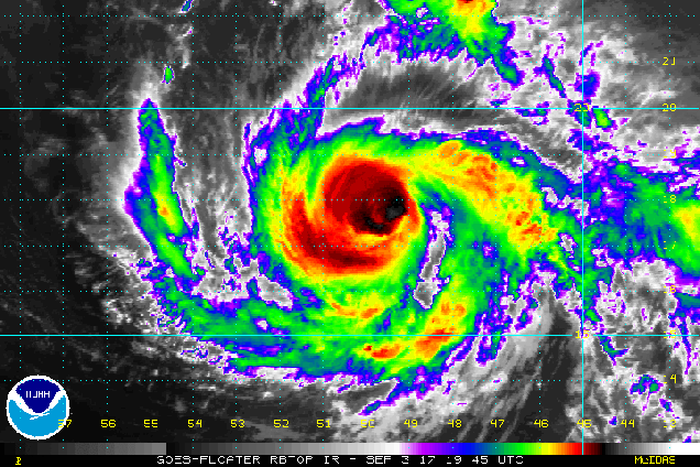
Visible satellite loop of Hurricane Irma early Wednesday afternoon. Loop provided by the College of DuPage.
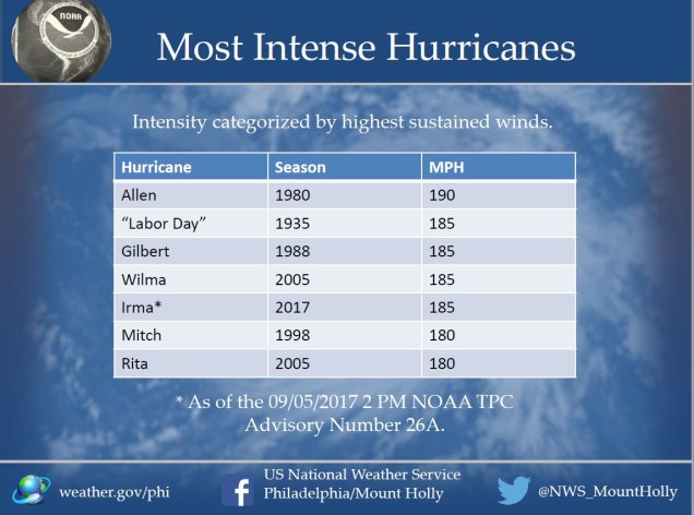
After moving across Barbuda, St. Barts, and St. Martin overnight, the eye of Hurricane Irma was moving across the British Virgin Islands Wednesday afternoon. When Irma moved across Barbuda last night it produced sustained winds of 118 mph with a gust to 155 mph, before the anemometer failed at an automated observing station. Sustained winds of 106 mph with a gust to 131 mph were reported at Buck Island in the US Virgin Islands this afternoon, while a wind gust to 113 mph was also reported in Estate Bovoni on St. Thomas in the US Virgin Islands. Irma should continue moving west-northwestward today and tonight, with the eye passing just north of St. John and St. Thomas in the US Virgin Islands. While this places these islands in the southern eyewall, believe it or not, things could actually be worse. The strongest winds in the storm have been observed in the northern eyewall, which will remain over open water. Maximum sustained winds in this part of the storm are estimated to be near 185 mph, making Irma one of the strongest storms ever in the Atlantic Basin. In fact, if you exclude the Gulf of Mexico and the Caribbean Sea. it is the highest winds in any hurricane in the Atlantic Ocean. Likewise, reconnaissance aircraft measured a pressure of 914 millibars in Irma’s center early Wednesday morning. Excluding the Gulf of Mexico and the Caribbean Sea again, this is the lowest pressure measured in a tropical system in the Atlantic Ocean. The old record was 915 millibars in Hurricane Isabel in 2003. The record low for the Atlantic Basin is 882 millibars set during Hurricane Wilma in 2005 in the northwestern Caribbean Sea.
The most intense hurricanes in the Atlantic Basin, ranked by maximum sustained winds. Image provided by the National Weather Service office in Mt. Holly, NJ.
Irma’s southern eyewall will likely move across northern Puerto Rico, possibly including the San Juan area. Hurricane strength winds were already moving into Culebra early Wednesday afternoon, with sustained winds to 73 mph and gusts as high as 96 mph reported. In addition to the wind, heavy rain is expected across the Virgin Islands and northern Puerto Rico. Rainfall totals of 5-10 inches with locally heavier amounts, will likely produce flooding in some areas. Lesser rainfall totals are expected across St. Croix as well as southern Puerto Rico.
Once Irma moves away from Puerto Rico, the obvious question becomes “Where will it go next?” Hurricane Warnings are in effect for the northern coast of the Dominican Republic and Haiti, as the storm will likely pass just north of those nations, but close enough to bring hurricane conditions to coastal locations. Hurricane Warnings are also in effect for the Southeastern Bahamas, as well as the Turks and Caicos Islands. Right now, Irma is expected to pass right across some of these islands as a Category 4 or 5 hurricane later Thursday into Friday. Beyond that, there is still a lot of uncertainty.
Track forecasts from the various members of the ECMWF Ensemble. Image provided by the University at Albany.
Track forecasts from the various members of the GFS Ensemble. Image provided by the University at Albany.
Track forecasts from the various members of the Canadian Ensemble. Image provided by the University at Albany.
Hurricane Watches have been posted for eastern Cuba as well as the Central Bahamas. Irma could be impacting either location by later on Friday. For the past few days, many of the forecast models showed the potential for Irma to head west-northwestward, possibly impacting or even making landfall in northern Cuba before making a sharp right turn and heading towards southern Florida. However, since last night, many of these models have started to shift a bit, now showing that turn coming earlier, with Irma possibly making landfall in south Florida this weekend, or possibly turning even earlier, and heading northward towards the coast of Georgia or the Carolinas. Even places farther up the coast might not be out of the woods yet either. At this point, it’s still too early to tell which scenario will be more plausible. Anyone with interests from North Carolina to Florida and the Bahamas should pay very close attention to Irma, and be prepared to take action on short notice.
Model forecasts for the track of Tropical Storm Jose. Could the Leeward Islands really get hit again a few days later? Image provided by the National Center for Atmospheric Research.
Meanwhile, Tropical Storm Jose is nearing hurricane strength in the Central Atlantic Ocean. As of midday Wednesday, Jose was centered about 1135 miles east of the Lesser Antilles, moving towards the west-northwest at 17 mph. Maximum sustained winds are near 70 mph, and Jose will likely strengthen into a hurricane later today. Jose is expected to turn more towards the northwest while strengthening over the next few days. While the storm is currently expected to pass north and east of the Leeward Islands, it wouldn’t take much of a shift in the track to bring the storm closer to areas that got hammered by Irma last night. That’s just what they need, right? Start the cleanup from one of the worst storms in history, then have another hurricane come by 4 days later? Look at the bright side – there wouldn’t be much left to damage.
Rainfall forecast for the next 5 days from the GFS model. At least the heavy rainfall is staying out of Texas for the most part. Image provided by WeatherBell.
We also have Tropical Storm Katia in the southwestern Gulf of Mexico. At midday Wednesday, Katia was centered about 175 miles north of Veracruz, Mexico, drifting east-southeastward at 5 mph. Katia has maximum sustained winds near 45 mph, and additional strengthening is expected. Katia should start to drift more towards the south and southwest while strengthening over the next day or two. Katia could become a hurricane before making landfall in Mexico towards the end of the week. Katia may produce heavy rain across parts of Mexico, with rainfall totals of 10 to 20 inches possible leading to flooding and mudslides across the area. Luckily, these rains will stay well south of the areas that Harvey flooded out a few weeks ago.
Irma is already a powerful storm, and will likely get even stronger. Loop provided by NOAA.
Before we get to the week ahead, we’ll address Irma, since we’ve been getting questions about it already. As of 11pm Sunday, Irma was centered a little more than 700 miles east of the Leeward Islands with maximum sustained winds near 115 mph. It is moving towards the west-southwest at 14 mph. Hurricane Watches have been posted for the islands in the northeastern Caribbean. Irma will turn more towards the west and west-northwest over the next few days, with some fluctuations in intensity. It will pass very close to the islands of the northeastern Caribbean on Tuesday, then likely pass just north of Puerto Rico and the Virgin Islands, before setting its sights on the southeastern Bahamas later this week. Beyond that? Well, that’s a question that really can’t be answered yet. The computer models, which can be notoriously bad more than a couple of days out, are all over the place. Just based on these, landfall, could occur anywhere between New Orleans and Nova Scotia, or not at all. It will be a few more days at least before we start to have any clarity on whether the storm will impact the United States or not. If it were, it wouldn’t happen until early next week anyway. We’ll likely have a special post about Irma later this week, where we take a deeper dive into the storm. For now, just keep an eye on it, especially if you live near the coast.
Model forecasts for the track of Hurricane Irma over the next 5-7 days. As you can see, it’s likely still at least a week away from any potential impacts to the US. Image provided by Tropical Tidbits.
As for what will happen up here, we’ve got a spectacular Labor Day coming up. As we read the traditional end of summer, it will certainly feel likely summer today with sunshine and warm temperatures. Tuesday will likely end up as another warm day, but the sunshine will disappear early behind increasing clouds. The more sunshine that we get, the warmer it will be. A cold front will slowly approaches the region, and may end stall out across the area. As a result, we’re looking at an extended period of wet weather starting late Tuesday or Tuesday night, going right into Thursday or perhaps even much of Friday. It’s not going to be raining the entire time, in fact, there may be extended stretches of time where it’s not raining, but for the most part, it will be cloudy, cooler, and damp, with occasional rain and thunderstorms. Some of the rain will be heavy, which is actually good news, since parts of the region are starting to slip back towards drought conditions. Once this front finally moves out on Friday, high pressure builds in next weekend with sunshine and milder conditions.
Latest updated on drought conditions across the Northeast. Image provided by the US Drought Monitor.
Labor Day: Sunshine and a few clouds. High 76-83.
Monday night: Mostly clear with some high clouds moving in late at night. Low 61-68.
Tuesday: Some early sunshine, then clouds thicken up. Showers and thunderstorms may develop late in the day, mainly north and west of Boston. Breezy. High 80-87.
Tuesday night: Showers gradually spread across the region. Low 62-69.
Wednesday: Cloudy with occasional showers and a few thunderstorms. High 70-77.
Thursday: Cloudy with more showers and drizzle expected. High 67-74.
Friday: More clouds than sun, some lingering showers, especially south of Boston. High 67-74.