A Little Snow to End February

As the headline implies, we’ve got some of the flaky white stuff on the way. This storm is going to be unlike any storm we’ve had all winter. It’s going to be all snow, and the fluffy type at that. It also, may cause problems for your Thursday morning drive to work or school.

High pressure is in place right now, with a cold and dry airmass settled into New England. Temperatures dropped into the single numbers and teens this morning, and at midday, dewpoints were still well below zero. As the high moves off the east, an Alberta Clipper will move in from the west. As it starts to spread precipitation into the region, it will run into this dry air this evening. So, even though the radar may show snow falling, it will evaporate before it hits the ground.

Very dry air remains in place at midday. This will help delay the snow’s arrival a little this evening. Image provided by WeatherBell.

Eventually, the atmosphere will moisten up enough so that the snow will make it down to the ground, and we’ll have some light fluffy snow falling through the overnight hours. It should taper off and end from the west to east right around the time most people head out to work or school in the morning. Road crews should have plenty of time to work on the getting everything cleared before the morning rush hour, but this being New England, where plenty of people completely forget how to drive as soon as they see a single raindrop, well, the snow will probably impact your morning drive, so leave a little extra time.

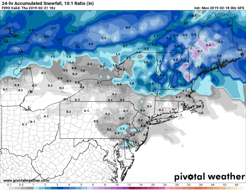
As for how much will fall, this won’t be a big deal, at least by New England standards. Most of the snow maps you see people post online (like the one below) assume a 10:1 ratio for snow to liquid. In many cases, this will work – 1 inch of rain equates to 10 inches of snow. However, the colder you get, the more the ratio changes. With temperatures in the teens, the ratio could be 20:1. For tonight’s storm, the ratio will probably end up somewhere around 15:1, so, you might expect a little more than the map below is showing. Remember – I also said that the initial burst of snow will likely evaporate before reaching the ground. The model assumes that anything showing up as precipitation does reach the ground, so it will assume we’ve got more precipitation than we actually will get. Plus, nearly every storm this winter has underperformed in the snow department, compared to what the models have forecast. So, factoring all that in, the 10:1 map may actually not be that bad after all.

OK, enough of the caveats and explanations, all you want to know is how much you’ll be cleaning off of your car or driveway in the morning.

Southern New Hampshire: 1-2″
Merrimack Valley/North Shore/Cape Cod/South Coast/Rhode Island: 1-3″
Metro Boston/MetroWest/South Shore: 2-4″

Given the fluffy nature of the snow, if a few places picked up 5″, especially from Worcester County into the South Shore, we wouldn’t be completely shocked.

We’ve been going with the High-resolution NAM all year, no reason not too once again. Image provided by Weathermodels.com

Another weak system will pass to our south Thursday night into Friday morning, with some light snow possible across the South Coast and Cape Cod, but the storm may end up too far south to impact us at all. Another system passes to the north late Saturday into early Sunday, and this one will be more typical of what we’ve seen this winter, with some light snow changing to sleet, freezing rain and eventually rain. What we’ve actually got our eyes on in the future is Sunday night and Monday. The models have been signalling for a few days the potential for a system to impact us then, but the details have been all over the place. The various models have shown solutions that range from a complete miss to snow to rain, to a heavy snowstorm. There’s still plenty of time for that to come into focus, and we’ll worry about it more as the weekend arrives. For now, we’ll just deal with the light snow tonight.

Weekly Outlook: February 25 – March 3, 2019

Meteorological winter runs from December 1 to February 28. Using that definition, winter ends this Thursday. That doesn’t mean that we’re done with wintry weather though. March is often a very wintry month, and we’ve had snow well into April and May before. Still, we’re getting closer and closer to warmer weather. You just won’t find any around here this week.

This week will start off very windy and quite chilly. Strong low pressure moving into Atlantic Canada will produce very powerful winds across the area today. Sustained winds of 25-35 mph are likely, with gusts of 50-60 mph or more. This will likely result in damage and power outages, so keep your electronics charged up, if possible. Not only will it be windy, but it’ll be chilly too, with highs only in the 30s.

Monday is really gonna blow…..hard. Image provided by Weathermodels.com

High pressure starts to build in on Tuesday with diminishing winds and colder conditions. Wednesday will also be chilly, with clouds starting to stream in ahead of an Albert Clipper. This will bring us some light snow late Wednesday into early Thursday, but it shouldn’t be a big deal – just a few inches seems most likely right now. It’ll be followed by another weak system that will pass through on Friday with little fanfare.

A little bit of snow is expected Wednesday night into early Thursday. Image provided by Pivotal Weather.

That brings us to next weekend, which looks awfully similar to what we’ve got right now. Another strong storm will move into the Great Lakes, with some rain likely on Saturday. It may start as a wintry mix, especially well inland, but for the most part, it looks like rain right now. Behind the storm, another windy and cold day looks likely on Sunday with some snow showers possible.

Monday: Intervals of clouds and sunshine, very windy. High 29-36.

Monday night: Becoming partly cloudy to clear, still windy. Low 12-19.

Tuesday: Brilliant sunshine, but breezy and chilly. High 22-29.

Tuesday night: Clear and cold. Low 4-11.

Wednesday: Some early sun, then clouding up with light snow likely late in the day and at night. High 20-27.

Thursday: Any lingering light snow ends early, sunny breaks develop in the afternoon. High 27-34.

Friday: More clouds than sunshine, slight chance for a snow or rain shower. High 33-40.

Saturday: Cloudy and breezy with showers likely, possibly starting as some sleet or freezing rain inland. High 39-46.

Sunday: Some sunshine early, then partly to mostly cloudy and windy with a chance of snow shower. High 29-36.

Weekly Outlook: February 18-24, 2019

You’re waking up to snow this morning, but that might not be the only snow for the week, at least for most of us. It is still February, so this should be expected.

The week is starting off with some snow, but since we discussed that in detail yesterday, and the bulk of the snow will be over by the time most of you read this, we won’t dwell on it much longer. Snow showers will continue into the afternoon, but little additional accumulation is expected. High pressure then builds in for tonight, Tuesday and part of Wednesday. This will give us drier but colder conditions. Again, it is February, this should be expected.

It’s still winter, so it shouldn’t be that warm. Average high temperatures for mid-February are in the upper 30s to lower 40s. Image provided by Weathermodels.com

By late Wednesday, another low pressure system will head towards the Great Lakes, just like a lot of them have already done so far this winter. As a result, we’ll see the same thing we have already seen plenty of times. Snow will develop Wednesday night, then warmer air will move in aloft, with a change to sleet and/or freezing rain early Thursday, and an eventual change to all rain as warmer air finally moves in at the surface. This doesn’t look like a big deal, with an inch or two of accumulation possible Wednesday night from the Merrimack Valley into southern New Hampshire.

A little bit of snow is expected early Thursday morning, mainly north of Boston. Image provided by Pivotal Weather.

The rain ends Thursday morning, then high pressure returns for later Thursday into Friday and Saturday. Then on Sunday, we do it all over again. Low pressure heads towards the Great Lakes again, and we get some snow, changing to sleet and/or freezing rain, then plain rain. Wash, rinse, repeat.

Monday: Cloudy with occasional snow showers tapering off and ending. High 27-34.

Monday night: Clearing. Low 9-16.

Tuesday: Partly to mostly sunny. High 24-31.

Tuesday night: Becoming partly to mostly cloudy. Low 9-16.

Wednesday: Cloudy with snow developing in the evening, changing to sleet, freezing rain, and rain from south to north overnight. High 25-32.

Thursday: Rain ending in the morning, then becoming partly sunny and breezy in the afternoon. High 42-49.

Friday: Intervals of clouds and sunshine. High 36-43.

Saturday: Some early sun, then becoming mostly cloudy. High 37-44.

Sunday: Cloudy, snow developing, quickly changing to sleet or freezing rain, then plain rain in the afternoon. High 40-47.

Monday Morning Mess?

While you’re enjoying a sunny Sunday, we’ve got some snow on the way tonight into Monday. It won’t be a lot, but it’ll probably make your morning drive to work into a large headache, especially south of Boston.

Low pressure will move out of the Ohio and Tennessee Valleys today and head east-northeastward, passing south of New England Monday morning. For once this season, we have enough cold air in place and a favorable storm track that we’ll be talking about all snow with this system, except possibly across parts of Cape Cod and the Islands. Since this is a fairly weak storm, we’re not talking about a lot of snow to begin with, and with it passing well to the south, the amounts will taper off quickly, the farther north you go.

The high resolution NAM model has a pretty good handle on how this storm will go, on our opinion. Loop provided by Tropical Tidbits.

The snow will develop late this evening from west to east, roughly in the 10pm-midnight time frame. It will continue through the overnight hours, and may even be briefly moderate to heavy south of Boston. While the steadiest snow looks to end during the morning hours on Monday, occasional light snow and snow showers will continue off an on during the afternoon, especially along the coastline. Everything should be done by evening.

So, how much are we looking at?
Southern NH/Southern ME: 1″ or less
Merrimack Valley: 1-2″
North Shore/Metro West: 1-3″
I-95 Corridor (Boston/Providence): 2-4″
Southeastern Mass/Southern RI: 3-6″, possibly a little more across Cape Cod

We’ve stuck with the high-resolution NAM for much of the winter, and it’s done pretty good, so we see no reason to go against it now. Image provided by WeatherBell.

Another storm may bring in more snow towards Wednesday, but we’ll have more details on that in our Weekly Outlook early Monday.

Weekly Outlook: February 11-17, 2019

Remember a few years ago when every single storm turned into a major snowstorm around here? In many ways, that was preferable to the winter we’ve had this year. Forecasting was a lot easier. Just forecast snow, and lots of it. Chances are, that’s what ended up happening. Not this year. This year, we get rain/snow lines, sleet, freezing rain, and a general mess with just about every storm. Well, there’s another one on the way.

The week actually starts out on a quiet note with high pressure to the north and a weak low pressure area passing well to the south. This will provided us with dry and seasonably cold conditions today. This is the proverbial “calm before the storm.” On Tuesday, low pressure will start to head towards the Great Lakes, sending clouds and precipitation into New England. It should be cold enough for it to start as snow across the region Tuesday afternoon. In fact, the snow may be quite heavy for a while Tuesday afternoon, which may result in the afternoon rush hour becoming utter chaos (not that it isn’t already). Eventually, warmer air will start to move in aloft, and then at the surface, which will result in a change to sleet and then freezing rain or rain from south to north during the evening hours. The questions are: 1. When does the change to sleet occur? 2. How long does it stay as sleet before changing to freezing rain? 3. When do temperatures get above freezing to end the icing threat? The answers to these questions will play an important role in how much of a mess things become.

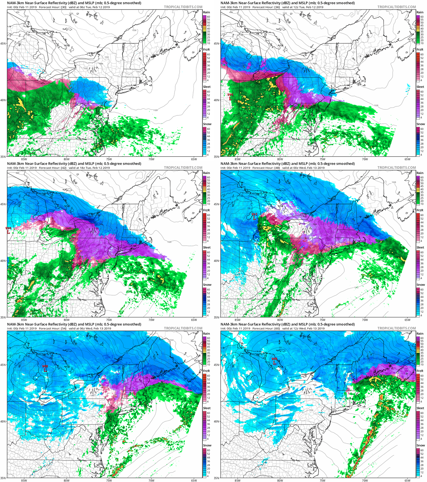
The NAM may be a little quick to bring in the sleet, and it has a lot of sleet, but it’s done fairly well this winter, so far. We’ll see how it does with this storm. Loop provided by Tropical Tidbits.

Eventually, a secondary area of low pressure will develop, and move across southeastern New England early Wednesday. This should allow most of the region to get above freezing and change to plain rain before everything winds down around daybreak Wednesday. So, how much snow are we expecting before the changeover?

Cape Cod/Southeast Massachusetts, Southern Rhode Island: 1-2″
I-95 Corridor (Boston/Providence): 1-3″
MetroWest/North Shore: 2-4″
Merrimack Valley/Southern NH/ NH Seacoast: 3-6″
Central NH/Southern ME (Concord/Portland): 4-8″

The FV3 model is probably closest to our thinking for snowfall amounts. Image provided by Pivotal Weather.

High pressure builds in behind the storm for late Wednesday and Thursday with dry and cooler conditions. However, another storm follows for Friday. This one looks to be milder, with mainly rain. However, it’s still 5 days away, and the models have been, well, not good, beyond about 3 days this winter, so we’ll obviously have to keep an eye on that one too. But for now at least, it looks like rain. High pressure builds in behind that storm next weekend with dry and colder weather.

Tuesday might suck weather-wise, but cheer up – pitchers and catchers report to Fort Myers for Spring Training on Wednesday! There will be actual games a week from Friday! Oh, and in case you forgot, the Patriots won the Super Bowl last week! Image provided by NESN.

Monday: Morning clouds, then becoming partly sunny. High 31-38.

Monday night: Clouds return. Low 13-20.

Tuesday: Cloudy with snow developing in the afternoon, possibly heavy at times. Snow will change to sleet along the South Coast towards evening. High 25-32.

Tuesday night: Snow changing to sleet, freezing rain, and eventually plain rain from south to north before ending by daybreak. Breezy. Temperatures slowly rise at night.

Wednesday: A lingering snow or rain shower is possible, otherwise skies will become partly sunny, breezy. High 39-46, possibly warmer across parts of southeastern Massachusetts and Cape Cod in the morning.

Thursday: Sunshine and a few clouds, still breezy. High 34-41.

Friday: Becoming partly to mostly cloudy with a few rain showers possible. High 43-50.

Saturday: Cloudy and breezy with a chance of rain. High 43-50.

Sunday: Partly to mostly sunny, breezy, and colder. High 29-36.

Weekly Outlook: February 4-10, 2019

We’ve certainly got an interesting week coming up, and we’re not just talking about the weather. Boston sports fans have two annual occurrences to look forward to this week – today is Truck Day, and tomorrow is Parade Day.

Yeah, we’re more than a little spoiled here in Boston. Image provided by WEEI.

Today is Truck Day – one of the first signs of Spring in New England. A truck filled with baseball equipment will leave Fenway Park today, bound for Fort Myers, Florida, where the Red Sox will begin spring training in about a week. Today will feel like Spring already, with a warm front to the north, resulting in temperatures getting into the 50s with some sunshine.

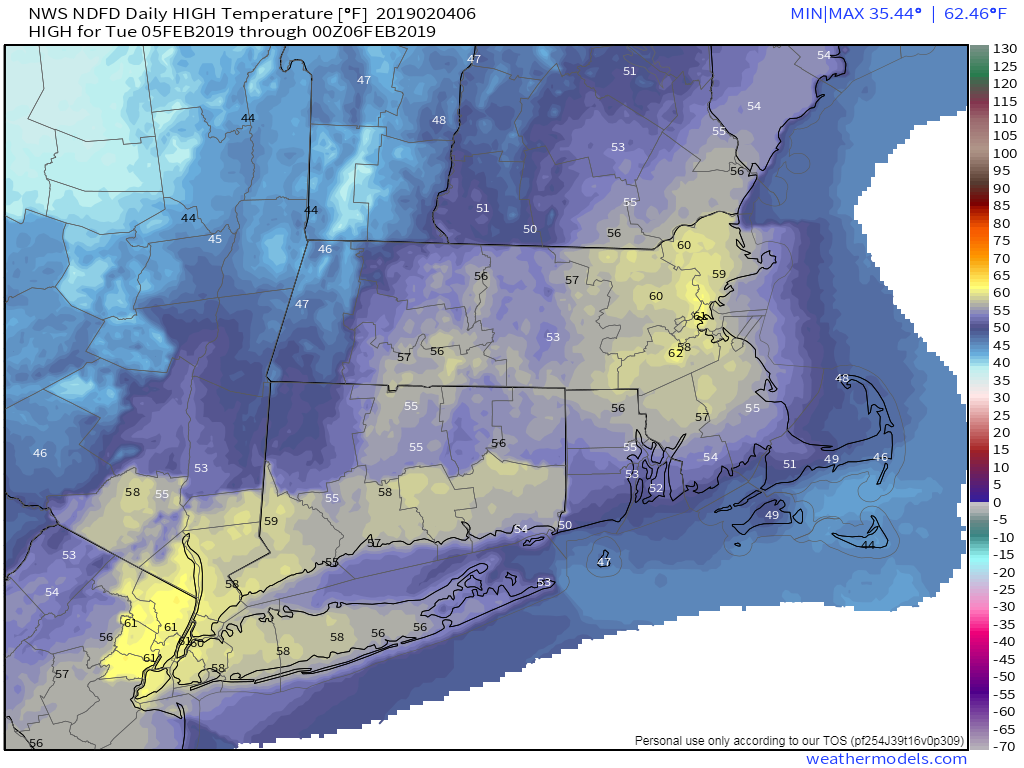
Tuesday is a more important day, as there will be another Championship Parade in the City of Boston – the 12th in 18 years. As a Boston sports fan, this does not get old, and we don’t care if the rest of the nation hate us. Tuesday will start off with some clouds, and possibly a few showers, as a weak system passes to the north, but it will be another warm day, with some places possibly reaching 60 degrees. The warmth will be short-lived, as a cold front moves through late in the day, snapping us back to reality Tuesday night and Wednesday as high pressure builds in with much cooler weather.

High temperatures near or above 60 on Tuesday? It’s a possibility. Image provided by Weathermodels.com

This brings us to the latter half of the week, where things get complicated. A system will move towards the region Wednesday night into early Thursday. This system will be fairly weak, but temperatures will be near or just below freezing when the precipitation moves in, especially north and west of Boston. So, we could be looking at some freezing rain, especially in southern New Hampshire and the Merrimack Valley. Temperatures will gradually warm above freezing everywhere as a second storm approaches for Thursday night into Friday. This will bring more rain into the area. Friday could also be a very mild day as this second system may pass well to our north and west, bringing a warm front through. Once it moves by, it drags a cold front across the region, then high pressure builds back in for next weekend with dry and colder conditions once again.

Freezing rain could cause some issues Wednesday night into Thursday morning across southern New Hampshire and northern Massachusetts. Image provided by Pivotal Weather.

Monday: Sunshine and a few clouds, milder. High 48-55, cooler across Cape Cod.

Monday night: Becoming partly to mostly cloudy, with a few showers possible, mainly north of Route 2. Low 32-39.

Tuesday: Early clouds, then becoming partly to mostly sunny and mild. High 52-59, cooler across Cape Cod.

Tuesday night: Partly cloudy. Low 21-28.

Wednesday: More clouds than sunshine. Rain developing at night, possibly starting as some freezing rain from the Merrimack Valley northward. High 35-42.

Thursday: Cloudy with freezing rain changing to rain before ending in the morning, then redeveloping in the evening. High 36-43.

Friday: Cloudy, breezy, and mild with rain ending during the afternoon. High 48-55.

Saturday: Mostly sunny, breezy, and much cooler. High 24-31.

Sunday: Early sunshine fades behind increasing afternoon clouds. High 27-34.