Hurricane Isaias Enters the Bahamas, East Coast on Alert

Tropical Storm Isaias strengthened into a hurricane early Friday as it pulled away from the Dominican Republic and headed towards the Bahamas. Meanwhile, the threat to the East Coast is starting to increase.

As of early Friday morning, Isaias was centered about 45 miles southeast of Great Inagua Island in the southeastern Bahamas, and was moving toward the northwest at 18 mph. Maximum sustained winds have increased to 80 mph based on recent data from reconnaissance aircraft. A Hurricane Warning is in effect for the northwestern, central, and southeastern Bahamas.Tropical Storm Warnings remain in effect for the entire Dominican Republic, the north coast of Haiti and the Turks and Caicos Islands. A Tropical Storm Watch is in effect for the east coast of Florida from Ocean Reef to Sebastian Inlet.

Forecast track for Huirricane Isaias. Image provided by the National Hurricane Center.

The short-term forecast for Isaias is rather simple. It will continue to move toward the northwest across the Bahamas while gradually slowing down. Waters remain very warm in this area (29-31C), and wind shear shouldn’t be that strong, which will allow Isaias to strengthen a bit more over the next day or two.

Sea Surface Temperatures are plenty warm enough to support a strengthening tropical system in the Bahamas. Image provided by WeatherBell.

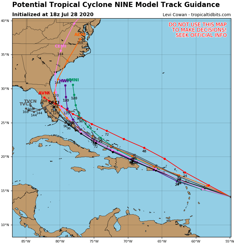
Once Isaias gets into the northwestern Bahamas, things get a bit trickier. A large high pressure area in the western Atlantic, and a trough of low pressure moving into the eastern United States will help to steer Isaias more towards the north-northwest, and then north, and eventually northeast. Exactly when those turns occur is critical to the forecast.

Model forecasts are fairly unanimous about a threat to parts of the East Coast. Image provided by WeatherBell.

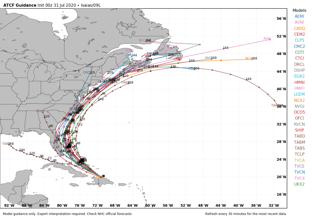
The current forecast calls for Isaias to make the northward turn east of Florida, sparing the Sunshine State from the worst of the storm. It may be close enough to bring some gusty winds and heavy rain to east-coastal Florida over the weekend, which is why the Tropical Storm Watch has been issued. That watch will likely be extended farther north on Friday. After that, it will head towards the Carolina coastline late Sunday into Monday. This is where the uncertainty is magnified.

If the Western Atlantic high is stronger than currently expected, or if the trough moving into the East is sharper than the models are currently showing, then Isaias will continue northward, likely moving across eastern North Carolina. A weaker high or flatter trough, would allow for a more northeastward movement, which could allow Isaias to only graze the Outer Banks or possibly even miss them completely.

GFS forecast for the upper-air pattern over the US for the next 5 days. Loop provided by Tropical Tidbits.

Once the storm is beyond the Carolinas, there is more uncertainty with its track. Again, a more northeastward motion would bring the storm out to sea with little additional impact to any land areas. A motion that is more toward the north-northeast or even north would increase the threat to parts of the Northeast, including New England, for late Monday or Tuesday.  As this point, coastal residents from Florida to New England should all keep tabs on the storm’s progress, as it could impact a large stretch of coastline this weekend and early next week.

If Isaias does make its way to New England as a hurricane, it would be extraordinarily early in the season for an impact up here. The earliest that a hurricane has ever made landfall in New York or New England was when Hurricane Belle slammed into Long Island with 90 mph winds on August 9, 1976. Hurricane Arthur passed just offshore of Nantucket on July 4, 2014. While it did not make landfall, it made for a rather wet and cool holiday, especially across Cape Cod and southeastern Massachusetts. Statistically, the most likely time for a hurricane to hit New England is between the middle of August and late September. Of the 18 hurricanes that made landfall in New England or Long Island since 1851, 16 of them have done so between August 19 and September 27. Since 1951, 36 storms have made landfall in New York or New England as tropical storms or hurricanes, but only 5 have done so before August 5.

  • An Unnamed Tropical Storm crossed Long Island on May 30, 2008 with winds of 45 mph.
  • An Unnamed Tropical Storm made landfall new Newport, RI on July 21, 1916 with winds of 70 mph.
  • Tropical Storm Cindy made landfall near Falmouth, MA on July 11, 1959 with winds of 60 mph.
  • Tropical Storm Agnes made landfall near New York City on June 22, 1972 with winds of 65 mph.
  • Tropical Storm Beryl crossed Nantucket with winds of 50 mph on July 21, 2006.
Isaias has produced tropical storm force winds across much of the northern and northeastern Caribbean. Image provided by the National Hurricane Center.

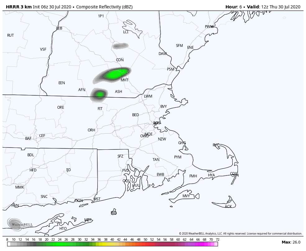
If it seems like we’ve been talking about this storm for a while, it’s because we have. Isaias was well-advertised by the models for almost a week before it finally developed over the eastern Caribbean on Wednesday. We even mentioned it in our Weekly Outlook early Monday morning. It has produced wind gusts of up to 60 mph and heavy rain that produce flooding across parts of the Virgin Islands, Puerto Rico, and the Dominican Republic. Wind gusts as high as 54 mph were also reported in the Turks and Caicos Islands Thursday evening.

Weekend Outlook: July 30-August 3, 2020

We’ll have a little bit of everything in the next few days, warm temperatures, high humidity, low humidity, thunderstorms, and maybe a tropical system.

A cold front will slowly cross the region today, with warm and humid conditions ahead of it. The front may trigger a few showers and thunderstorms, somke of which could contain gusty winds and heavy downpours, but widespread severe weather is not expected.

Some thunderstorms may move across the region ahead of a cold front this afternoon and evening. Loop provided by WeatherBell.

The front may hang up near the South Coast early Friday, otherwise, everyone else should start to clear out with drier air settling in. High pressure builds in for the rest of the day on Friday and into Saturday with seasonably warm temperatures but comfortable humidity levels.

Dewpoints will drop into the 50s across much of the region on Friday. Image provided by Weathermodels.com

Low pressure starts to move toward the region on Sunday, with a war front bringing in more humid conditions, along with the possibility of some showers and thunderstorms. With some cloud cover it shouldn’t be as hot as recent days, but it will be quite warm.

This sets the stage for Monday, which is a VERY uncertain forecast at this time. We’ll need to keep an eye on what happens with Tropical Storm Isaias. Some models show the potential for the storm or its remnants to move up the coast either Monday or Tuesday. At this point, we really can’t rule out any scenario. It’s still too early to determine what, if any, impact it has up here, but we should start to get a better idea over the next couple of days. We’ll likely have multiple blog posts about Isaias between this evening and this week, so we’ll keep you informed.

Will Isaias head up the coast? It looks that way, but exactly where is still a question. Image providsed by WeatherBell.

Thursday: More clouds than sunshine, chance for some afternoon showers and thunderstorms, mainly south of the Mass Pike. High 85-92.

Thursday night: Showers gradually ending along the South Coast, skies start to clear out north of the Mass Pike. Low 64-71.

Friday: Becoming partly to mostly sunny and less humid. High 81-88.

Friday night: Clear to partly cloudy. Low 63-70.

Saturday: A mix of sun and clouds. High 84-91.

Saturday night: Increasing clouds. Low 63-70.

Sunday: More clouds than sunshine with a chance for showers and thunderstorms. High 80-87.

Sunday night: Partly to mostly cloudy with more showers and thunderstorms possible. Low 67-74.

Monday: Partly sunny with a chance for a hurricane. Plenty of clouds with a chance for showers and thunderstorms. High 84-91.

Another Tropical System to Watch

We’ve been mentioning for several days now that a wave in the Atlantic needed to be watched for development. It isn’t a tropical cyclone yet, but it appears to be a matter of when, not if, it will become one.

The disturbance east of the Antilles is still trying to organized itself this afternoon. Loop provided by NOAA.

While the system has a broad circulation and plenty of thunderstorm activity, it has not become a tropical cyclone as of yet. Until that circulation tightens up into a well-defined low-level center, it is just a tropical disturbance. The National Hurricane Center has dubbed it “Potential Tropical Cyclone Nine” as of midday Tuesday. This designation allows the issuance of Tropical Storm Watches and Warnings for many of the islands in the northeastern Caribbean, including Puerto Rico and the Virgin Islands. The center of the system is estimated to be about 500 miles east of the Lesser Antilles. It is moving toward the west at 23 mph, and has maximum sustained winds of 40 mph. The expectation is that the circulation will tighten up and the system will become a tropical storm in the next 24 hours. If it does, it will be given the name Isaias (pronounced ees-ah-EE-ahs). This has already led to many in the media and on the internet saying that it is the earliest “I” storm on record. This is true, but it ignores the fact that at least 2 of the storms we’ve had so far this season should not have been named.

Forecast track for Potential Tropical Cyclone Nine. Image provided by the National Hurricane Center.

Air Force reconnaissance aircraft are out investigating the system this afternoon, trying to determine its strength and whether it has developed a low-level center yet. Once that center does develop, we’ll have a better idea of where the system may go. Right now, the forecast is for the system to cross the Lesser Antilles early Wednesday, then move across the Virgin Islands and Puerto Rico Wednesday night and early Thursday. However, if recon finds that the center has developed in a spot that is not near where the Hurricane Center currently thinks it is, that will obviously have implications on the track of the system. Changes to the track will also have implications for how strong to system gets. As we’ve been saying for a few days now, until the system actually develops, all model forecasts for the system are suspect.

Model forecasts for the track Potential Tropical Cyclone Nine. Image provided by Tropical Tidbits.

Obviously, minor details could have major implications om the system’s future, but right now, it looks like it will track near or just north of the Greater Antilles. How close to passes to the islands will determine it’s strength. The closer it is, the more likely it is that the mountains of Hispaniola disrupt the circulation and keep it weak. The farther away, the more likely it stays mostly over water and strengthens while possibly impact the Bahamas along the the Turks and Caicos Islands. We’re not even going to speculate beyond that, because even forecasting this far out is more speculation than we’d like. We’re highly aware that many models, especially the ensembles show a threat to the East Coast, literally anywhere from Florida to Nova Scotia. We’re not ruling that out yet, but again, it is pure speculation at this point. We’ll say it again – once the system actually develops, we’ll start to have a better idea of where it’s going and how strong it may be. For now, it’s just something to keep an eye on.

Weekly Outlook: July 27-August 2, 2020

Heat and humidity continue across the region for a couple more days before relief arrives on Wednesday.

Heat Advisories are in effect for much of the region for today and Tuesday. Image provided by Pivotal Weather.

A ridge of high pressure remains in control, so stifling heat and humidity will remain in place until Tuesday. Today looks to be the hottest day, with temperatures well into the 90s. A few places could reach 100, but triple-digit heat shouldn’t be widespread. It will be very humid as well, sending the heat index well above 100 across the region, but dewpoints may actually drop a bit during the afternoon. Tonight will be downright uncomfortable without air conditioning, as low temperatures will only drop into the middle to upper 70s in many areas, and some urban areas, especially Boston, may not drop below 80.

Temperatures may struggle to drop below 80 in some spots Monday night. Image provided by WeatherBell.

Tuesday will start off very warm and humid, so it won’t take much to send temperatures above 90 once again, but clouds will also start to increase in the afternoon as a cold front approaches the region. This front may produce a few showers and thunderstorms late in the day and at night. Some of these storms may produce some heavy downpours and gusty winds, but we’re not expecting widespread severe weather.

There is a marginal risk for severe weather on Tuesday across the region. Image provided by the Storm Prediction Center.

The front slides offshore early Wednesday, then high pressure builds in for the rest of the week and into the weekend. It be a bit cooler, but still near to a little above normal for the end of July, but the more noticeable effect will be that it is drier, with dewpoints only in the 50s to lower 60s.

Monday: Sunshine and some high clouds around, hot and humid. High 92-99.

Monday night: Clear to partly cloudy. Low 72-79.

Tuesday: Sunny early, then clouds move in with some showers and thunderstorms possible late in the day. High 90-97.

Tuesday night: Showers ending during the evening, though possibly lingering for much of the night near the South Coast. Low 67-74.

Wednesday: Lingering clouds along the South Coast early, otherwise becoming partly to mostly sunny and not as humid. High 85-92.

Thursday: Sunshine and some afternoon clouds. High 83-90.

Friday: A mix of sun and clouds. High 81-88.

Saturday: Partly to mostly sunny. High 81-88.

Sunday: Partly sunny. High 82-89.

Model forecasts for the track of a tropical disturbance in the Central Atlantic. Image provided by WeatherBell,

Finally, we’ll mention the tropical disturbance in the Central Atlantic, since the hype train is already getting set to leave the station. Yes, there are a few models that show a potential threat to the East Coast in about 7-10 days. These should be treated the same as model forecasts in January that show a raging blizzard 7-10 days out. The probability of it happening is still fairly low. The system itself hasn’t even become a tropical depression yet. That may occur later Monday or Tuesday. If (when?) it does, we’ll write a blog post about the storm and it’s future. For now, it has our attention, but that’s it.

Douglas, Gonzalo, and Hanna All Threaten Land

Between the Atlantic and the Central Pacific Ocean we have three named storms, and all of them will threaten land areas this weekend.

Tropical Storm Hanna continues to strengthen in the western Gulf of Mexico. Loop provided by NOAA.

We’ll start again with Tropical Storm Hanna, since it is the most immediate threat to land. As of 8pm EDT, the system was centered about 190 miles east-of Corpus Christi, Texas, moving toward the west at 10 mph. Maximum sustained winds were near 50 mph and additional strengthening is likely. Hanna could become a hurricane before making landfall in south Texas on Saturday. A Hurricane Warning is in effect for the Texas coast from Baffin Bay to Mesquite Bay, and a Storm Surge Warning is in effect from Baffin Bay to Sargent. A Tropical Storm Warning is also in effect from Baffin Bay southward to the mouth of the Rio Grande, and from Mesquite Bay northward to San Luis Pass.

Forecast track for Tropical Storm Hanna. Image provided by the National Hurricane Center.

A storm surge of 2-4 feet is likely near and to the north of landfall. and strong winds are also likely near the coast and a short distance inland near landfall, but heavy rain and inland freshwater flooding remains the biggest threat with this system. Slow-moving tropical systems have produced significant rainfall in Texas many times before, and while we’re not expecting 50+ inches like Hurricane Harvey produced a few years ago, widespread totals of 6-12 inches with isolated amounts of up to 20 inches are possible through early next week. To the north, rainfall of 2-6 inches will likely cause flooding from Austin and San Antonio over to Houston.

Hanna will produce very heavy rainfall across South Texas over the next several days. Image provided by WeatherBell.

While Hanna is the immediate threat to the US, out in the Atlantic, Tropical Storm Gonzalo is a threat to the southern Windward Islands. As of 8pm EDT, Gonzalo was centered about 340 miles east of the southern Windward Islands, moving toward the west at 18 mph. Maximum sustained winds have decreased to near 45 mph. Drier air has taken a toll on the system, and will continue to do so. A Tropical Storm Warning remains in effect for St. Vincent and the Grenadines, Tobago, and Grenada.

Forecast track for Tropical Storm Gonzalo. Image provided by the National Hurricane Center.

Gonzalo’s future remains very uncertain. The official forecast calls for Gonzalo to restrengthen a little over the next 24 hours, then weaken and dissipate after moving into the eastern Caribbean. However, at this point, it is just as like that it weakens and opens up into a wave before it crosses the islands on Saturday. No matter what it does, it will bring some squally weather to parts of the southern Windward Islands on Saturday. We’ll also need to keep an eye on what the remnants of the system do as they move across the Caribbean. Conditions in the western Caribbean could be a bit more favorable early next week and the water is plenty warm, so regeneration is not out of the question.

In the Central Pacific Ocean, Hurricane Douglas is starting to slowly weaken after peaking as a Category 4 Hurricane on Thursday. As of 8pm EDT, Douglas was centered about 725 miles east-southeast of Hilo, Hawaii, moving toward the west-northwest at 18 mph. Maximum sustained winds have decreased to 115 mph, making Douglas a Category 3 storm on the Saffir-Simpson scale. Some additional weakening is expected on Saturday as Douglas moves over cooler waters. A Hurricane Watch has been posted for Hawaii County and Maui County, including Maui, Lanai, Molokai, and Kahoolawe.

Forecast track for Hurricane Douglas. Image provided by the Central Pacific Hurricane Center.

The forecast track for Douglas has shifted northward a bit over the past 24 hours, but still indicates the potential for Douglas to impact Hawaii as a weakening hurricane on Sunday, though some models keep the center north of the island chain completely. Rough surf, gusty winds, and heavy rainfall are likely across the islands starting late Saturday and continuing into Monday. Rainfall totals of 6-12 inches and locally up to 20 inches may cause flooding in some areas.

Finally, we’re keeping our eyes on a tropical wave in the eastern Atlantic Ocean. The wave isn’t that organized right now, but as it crosses the Atlantic, conditions could become more favorable for development. In fact, many models do show this developing into a tropical cyclone towards mid-week, and possibly becoming a threat to the eastern Caribbean by late next week. Model forecasts 5-7 days out aren’t terribly reliable, but there are some that show the system becoming a threat in about 10-12 days to anywhere from Central America to the Gulf to the East Coast, to Bermuda, to a system that passes harmlessly out to sea. In other words, it’s WAY to early to speculate about a system that hasn’t even formed yet. Yes, it’s something to watch, but that’s about it right now.

Weekend Outlook: July 24-27, 2020

This outlook will be rather brief, because the forecast is rather simple. We’ll dry out today and Saturday, then heat and humidity return for Sunday and Monday.

Monday looks to be the hottest day, when the heat index could reach 100 in some spots. Image provided by WeatherBell.

Friday: Becoming partly to mostly sunny and less humid. High 80-87.

Friday night: Mostly clear skies. Low 63-70.

Saturday: Partly to mostly sunny. High 83-90.

Saturday night: Clear to partly cloudy. Low 66-73.

Sunday: A mix of sun and clouds, hot, and humid. High 88-95.

Sunday night: Partly cloudy and muggy. Low 69-76.

Monday: Partly sunny, hot, and humid. High 89-96.

Tropical Storm Gonzalo looks healthier and TD 8 has become Tropical Storm Hanna in the Gulf of Mexico. Loop provided by NOAA.

We’ll likely publish another blog on the tropics late Friday, but here’s a quick update for you. Tropical Depression 8 has become Tropical Storm Hanna. Tropical Storm Warnings are now in effect for much of the Central and Southern Texas coast, all the way to the mouth of the Rio Grande. A track towards South Texas is likely with landfall on Saturday. Heavy rain is still the main threat. Tropical Storm Gonzalo looks a little healthier this evening, and will likely cross the southern Windward Islands on Saturday. Once it gets past the islands, its future is still very uncertain. In the Eastern Pacific, Douglas is now a Category 4 Hurricane, but will likely start to weaken today. It should pass very close to or right across the Hawaiian Islands on Sunday as either a weakening hurricane or a strong tropical storm.

Triple Trouble in the Tropics?

Scheduling Note: Our Weekend Outlook will be published early Friday this week instead of Thursday afternoon as it usually is.

The tropics had been relatively quiet in the past couple of weeks, but we suddenly have 3 storms that are all threats to land.

Tropical Depression 8 is trying to get organized in the Gulf of Mexico while Tropical Storm Gonzalo heads toward the Windward Islands. Loop provided by NOAA.

We’ll start with Tropical Depression 8, since it is the most immediate threat to land. As of 11am EDT, the system was centered about 380 miles east-southeast of Port O’Connor, Texas, moving toward the west-northwest at 9 mph. Maximum sustained winds were near 35 mph. The system should continue on a general westward track for the next day or two, with some strengthening possible. As a result, a Tropical Storm Watch is in effect for the Texas coast from Port Mansfield to High Island.

Forecast track for Tropical Depression 8. Image provided by the National Hurricane Center.

While gusty winds and some rough surf are likely along the Texas coast, the biggest threat from this system will be heavy rainfall. Slow-moving tropical systems have produced significant rainfall in Texas many times before, and while we’re not expecting 50+ inches like Hurricane Harvey produced a few years ago, widespread totals of 3-6 inches with isolated amounts of up to 10 inches are possible this weekend. That would produce flooding in many areas.

TD 8 will produce heavy rain across much of southern Texas and parts of the Gulf Coast. Image provided by Weathermodels.com

While TD 8 is the immediate threat to the US, out in the Atlantic, Tropical Storm Gonzalo presents a threat to parts of the Windward Islands. As of 11am EDT, Gonzalo was centered about 885 miles east of the southern Windward Islands, moving toward the west at 14 mph. Maximum sustained winds are near 65 mph. A Hurricane Watch is in effect for Barbados as well as St. Vincent and the Grenadines.

Forecast track for Tropical Storm Gonzalo. Image provided by the National Hurricane Center.

Gonzalo’s future is very uncertain. The official forecast calls for Gonzalo to become a hurricane later today, then start to weaken after moving across the Windward Islands this weekend and into the eastern Caribbean. However, Gonzalo looks less organized on satellite photos today, and is fighting off some dry air aloft. There is a decent chance that the system could weaken or even open up into a wave before reaching the Windward Islands. How it develops over the next 12-24 hours will give us a much better idea of what the future holds for it.

In the Eastern Pacific Ocean, Hurricane Douglas continues to strengthen this morning, and could become a threat to Hawaii this weekend.

Hurricane Douglas continues to strengthen in the Eastern Pacific Ocean. Loop provided by NOAA.

As of 11am EDT, Douglas was centered about 1335 miles east-southeast of Hilo, Hawaii, moving toward the west-northwest at 20 mph. Maximum sustained winds have increased to 120 mph, making Douglas a Category 3 storm on the Saffir-Simpson scale. Some additional strengthening is possible today before a weakening trend begins on Friday as Douglas moves over cooler waters.

Forecast track for Hurricane Douglas. Image provided by the National Hurricane Center.

Douglas is expected to only gradually weaken while heading towards the west-northwest over the next several days. On this track, Douglas is expected to pass close to or over parts of the Hawaiian Islands this weekend. Obviously which islands would be impacted and what the threats would be will depend on the exact track Douglas takes, as well as how quickly it weakens. At this point, gusty winds, heavy rainfall, and rough surf appear mostly likely for the Big Island, but the entire island chain could be impacted.

While Hawaii has been impacted by many weakening storms passing by the islands, a direct hit is actually fairly rare. Since 1871, only 3 hurricanes and 4 tropical storms have actually made landfall on the islands. The last system to make landfall in Hawaii was Tropical Storm Olivia in 2018. The last hurricane to make landfall in Hawaii was Hurricane Iniki in 1992.

Very few tropical systems actually make landfall in Hawaii. Image provided by NOAA.

Beyond these systems, there’s nothing on the immediate horizon. Some of the longer-range ensemble models are showing the potential for a wave to move off the the African coast and develop while crossing the Atlantic next week. This is still several days away, and while the likelihood of it happening is fairly low, we are getting into the time of year when some of these waves do start rolling off of Africa and maintain themselves while crossing the Atlantic. Just like in the winter when you’ll see Day 16 model images of a mega-blizzard for the Northeast, we’re already seeing people posting model images for a potential East Coast hurricane 2 weeks from now. Don’t buy into the hype. Until something actually develops, it doesn’t exist, let alone present a threat.

Weekly Outlook: July 20-26, 2020

This week will feature a little bit of everything, at least in terms of summer weather.

Heat Advisories are in effect for much of the I-95 corridor from Portland, ME to Richmond, VA again today. Image provided by Pivotal Weather.

We start the week off with more heat and humidity today. Offshore high pressure continues to pump hot and humid weather in, and as a result, Heat Advisories remain in effect for a large portion of the region. Highs will get into the 90s again for much of the area today, with dewpoints in the upper 60s to middle 70s. That combination of heat and humidity will make it feel like its 100 or higher during the afternoon. Relief is on the way though, as a cold front will move across the region later today. This front may produce some showers and thunderstorms, but we’re not that confident that we’ll see widespread activity. Any storms that do form may produce heavy downpours and strong winds, but a severe weather outbreak doesn’t look likely at this point.

The combination of heat and hmidity will make it feel like its over 100 this afternoon. Image provided by WeatherBell.

The front moves offshore tonight, and “cooler” and “drier” air settles in for Tuesday. While it won’t exactly be a lot cooler or a lot drier, it will still be more comfortable compared to today. Our respite doesn’t last long though as a warm front approaches on Wednesday. While the front may produce a few showers or thunderstorms, the more noticeable impact will be to bring the humidity back in. It’ll be quite warm as well, but cloud cover will prevent us from getting too hot once again.

We need any rain we can get. Precipitation is well below normal over the past couple of months across the region. Image provided by the Northeast Regional Climate Center.

Another cold front approaches on Thursday, with more showers and thunderstorms expected. Again, some of them could be quite strong, but a widespread severe weather event doesn’t appear likely at this time. Much cooler and drier weather does finally move in behind this front for Friday and Saturday. As for next Sunday, that’s a bit of a question mark at this point. Most of the models show a storm system passing to the north, but that’s where the similarities end and the story of Goldilocks and the Three Bears starts. One model has little to no precipitation, with hot and humid conditions. Another has it warm but dry with precipitation moving in at night. A third model has it cloudy and mild with showers during the afternoon. We’re going to play the middle ground right now, knowing full well that we’ve got plenty of time for the models to find some common ground and decide on a solution before we issue our Weekend Outlook Thursday afternoon.

Dewpoints in the 40s and 50s by Saturday would be a welcome change. Image provided by Weathermodels.com

Monday: Some dense fog along the South Coast early, otherwise a mix of sun and clouds with some showers and thunderstorms developing during the afternoon. A few of the storms may produce gusty winds and heavy downpours. High 89-96, cooler right along the South Coast. Heat indices could reach as high as 104 in some spots.

Monday night: Clearing and less humid. Low 65-72.

Tuesday: Sunshine and a few clouds. High 85-92.

Tuesday night: Clear to partly cloudy. Low 63-70.

Wednesday: Partly sunny and humid with some afternoon and evening showers and thunderstorms possible. High 82-89, cooler along the coast.

Thursday: Intervals of clouds and sun with some showers and thunderstorms during the afternoon and evening, breezy. High 82-89.

Friday: Partly to mostly sunny and drier. High 77-84.

Saturday: Sunshine and some high clouds. High 80-87.

Sunday: More clouds than sun with showers and thunderstorms possible late in the day and at night. High 83-90.

Weekend Outlook: July 17-20, 2020

Your air conditioner has gotten a much-needed rest for the past few days, but it’s about to get a workout. Some typical summertime weather is coming up for the weekend with heat and humidity settling into New England.

Midday temperatures in the 70s in mid-July? It doesn’t get much better than that. Image provided by NOAA.

High pressure remains in control today with mild temperatures (a little below normal for mid-July) and comfrtoable humidity levels, but that’s about to change. A warm front will send clouds into the region tonight, with some showers and thunderstorms likely on Friday. Most of the storms shouldn’t be that strong, but could contain some heavy downpours. We’re not expecting much, if any, severe weather. Temperatures will remain a little below normal, but it will be breezy and significantly more humid.

Dewpoints could reach the lower to middle 70s by Monday across the region. Image provided by Weathermodels.com

High pressure builds in for the weekend and with it comes the heat and humidity. Temperatures will be near or above 90 on Saturday, and should be in the 90s away from the South Coast for Sunday and Monday. Dewpoints will likely get above 70 for Sunday and Monday as well, so it will be quite uncomfortable if you’re outside for any length of time, as the heat index will be apporoaching (or even exceeding) 100 in some spots. We may get a little relief Monday afternoon as a weak disturbance moves through, triggering a few showers and thunderstorms, but that’s about it.

The heat index will be near or over 100 across the region Monday afternoon. Image provided by WeatherBell.

Thinking about heading to the beach or out on a boat? Temperatures will be in the upper 70s to lower 80s at beaches along the South Coast and lower to middle 80s at beaches along the east coast this weekend. You’ll have south winds 10-15 mph on Friday, becoming southwest over the weekend, and seas generally 1-3 feet. With a UV Index in the very high range, you’ll start to get a sunburn in just 15 minutes or so, so make sure you put on sunscreen!

Thursday night: Becoming mostly cloudy, a few showers are possible towards daybreak. Low 56-63.

Friday: Plenty of clouds with scattered showers and thunderstorms. High 71-78.

Friday night: Clearing. Low 63-70.

Saturday: Sunshine and a few afternoon clouds, humid. High 86-93.

Saturday night: Clear skies. Low 65-72.

Sunday: Mostly sunny, hot, and humid. High 90-97, a little cooler right at the coast.

Sunday night: Clear to partly cloudy. Low 71-78.

Monday: Partly to mostly sunny, hot, and humid, chance for a few showers and thunderstorms. High 90-97, a little cooler right at the coast.

Weekly Outlook: July 13-19, 2020

Much of this week will feature typical summer-time weather in New England, with warm to hot temperatures, humidity levels ranging from somewhat comfortable to not very comfortable, and some pop-up showers and thunderstorms.

There is a marginal risk for a few severe thunderstorms this afternoon and evening. Image provided by the Storm Prediction Center.

The week starts off with the most active weather day as a cold front starts to approach the region. A few showers are likely this morning as an upper-level disturbance swings through, but we should see some sunshine develop by midday. How much sunshine we get will help determine how much the atmosphere will destabilize again in the afternoon. As the front moves in from the west, showers and thunderstorms will develop. Many of these storms will produce heavy downpours, and some could redevelop over the same locations, resulting in some flash flooding. Depending on how much sun we see in the late morning and early afternoon, we could be looking at some severe storms, with strong winds and hail as well. There is even a slight chance for a tornado to form. How quickly the front moves will also help determine how long we’ll be dealing with the storms, and what areas have the best chance to have them. Right now, it looks like most of the storms will be during the 1pm-8pm time frame.

The HRRR model depicts a possible scenario for thunderstorm development today. Loop provided by Weathermodels.com

The front moves offshore tonight, and cooler and drier air starts to settle in. However, an upper-level low pressure area will be moving in at the same time. As this upper-level low moves right across New England on Tuesday, it will help produce another round of showers and thunderstorms during the afternoon. Most of these shouldn’t be strong, but with a pool of cold air aloft, we could see some small hail in a few of them.

Dewpoints could drop into the upper 50s to lower 60s by Wednesday afternoon. Image provided by WeatherBell.

The upper-level low moves offshore for Wednesday, and we’ll be under the influence high pressure for Wednesday and Thursday, with sunshine, seasonably warm temperatures (tempered by a seabreeze along the coast), and moderate humidity levels. Warmer and more humid air moves in for Friday and the weekend. A series of weak upper-level disturbances will also move across the region, creating a daily chance for showers and thunderstorms.

Heat and humidity return to the region next weekend. Image provided by Pivotal Weather.

Monday: A few showers early, then becoming partly sunny. Showers and thunderstorms are likely during the afternoon and evening. Some of them may produce heavy downpours. High 82-89.

Monday night: Showers and thunderstorms end during the evening, then skies clear out. Low 62-69.

Tuesday: A sunny start, then clouds develop with a few showers and thunderstorms likely during the afternoon. High 76-83.

Tuesday night: Clear to partly cloudy. Low 59-66.

Wednesday: Sunshine and a few clouds. High 72-79, coolest along the coast.

Thursday: Some patchy morning fog, then becoming partly to mostly sunny. High 74-81, coolest along the coast.

Friday: Intervals of clouds and sunshine with some showers and thunderstorms possible, especially during the morning, a little more humid. High 77-84.

Saturday: Partly sunny, chance for a shower or thunderstorm. High 83-90, cooler along the coast.

Sunday: A mix of sun and clouds, a shower or thunderstorm is possible. High 86-93.