We’re going to keep this very brief today, but give you a look into Labor Day.
Warm and humid conditions are likely today ahead of a cold front. That front will produce showers and thunderstorms. some of which may be strong to severe. Drier air settles in behind the front for Tuesday as high pressure builds in. What’s left of Ida may bring in some heavy rain for Wednesday into Thursday. High pressure returns for Friday into Sunday with cooler and drier conditions, but we’ll start to warm up again for Labor Day with some showers and thunderstorms possible.
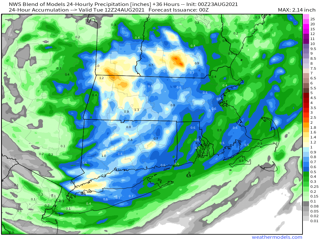
The models all show some heavy rain with what’s left of Ida, but don’t agree on how much. Images provided by Pivotal Weather.
Monday: Partly sunny with showers and thunderstorms developing in the afternoon. High 80-87.
Monday night: Showers and storms end in the evening, then becoming partly cloudy. Low 62-69.
Tuesday: More clouds than sun, not as humid. High 79-86.
Tuesday night: Partly cloudy. Low 60-67.
Wednesday: Cloudy with showers developing late in the day, possibly becoming a steady and heavy rain at night. High 72-79.
Thursday: Rain gradually ending, some clearing is possible late in the day. High 66-73.
Friday: Partly to mostly sunny. High 69-76.
Saturday: A mix of sun and clouds. High 69-76.
Sunday: Partly sunny. High 71-78.
Labor Day: Partly sunny with showers and thunderstorms possible. High 72-79.
We’ll return to our more customary detailed look at things with the Weekend Outlook on Thursday, once we’re back from vacation (no, we weren’t chasing Ida in Louisiana).
The heat and humidity are on the way out, with cooler temperatures and more clouds on the way for the weekend.
The heat and humidity will continue into Friday with high pressure offshore, but a backdoor cold front will drop southward by late in the day. As the winds shift into the east and northeast, much cooler air will settle into the region. The front may be accompanied by a few showers or thunderstorms, but much of the region should remain dry.
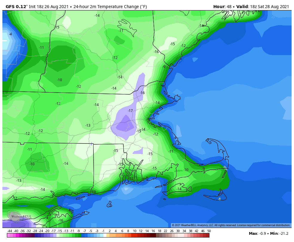
Temperatures Saturday afternoon could be as much as 10-20 degrees cooler than Friday afternoon. Image provided by WeatherBell.
That front will stall out just to our south for the weekend, keeping plenty of clouds in place along with the cooler temperatures. By later on Sunday, that front will start to lift northward again as a warm front. This may bring in a better chance for showers and thunderstorms for Sunday night and Monday, but it will also bring warmer and more humid weather back in.
Thursday night: Partly cloudy. Low 67-74.
Friday: A mix of sun and clouds, slight chance for a shower. High 85-92.
Friday night: Partly to mostly cloudy. Low 60-67.
Saturday: More clouds than sun. High 70-77, coolest along the coast.
Saturday night: Mostly cloudy. Low 57-64.
Sunday: Intervals of clouds and sun. High 72-79.
Sunday night: Partly cloudy, chance for a few showers. Low 62-69.
Monday: More clouds than sun with some showers and thunderstorms possible. High 79-86.
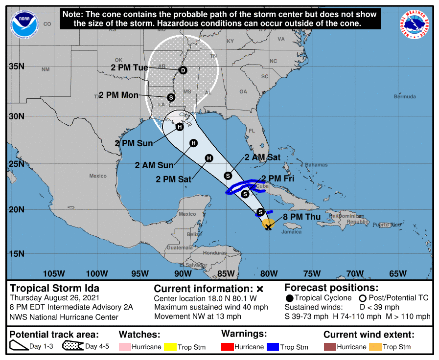
Forecast track for Tropical Storm Ida. Image provided by the National Hurricane Center.
Finally, a quick word on the tropics. Tropical Storm Ida has developed west of Jamaica. Current forecasts call for it to rapidly strengthen and head northwestward. It could become an increasing threat to parts of the Gulf coast, especially Louisiana or Mississippi, by late in the weekend as a hurricane, possibly a very strong one. There are two other areas, one east of Bermuda and another east of the Lesser Antilles, that could also become tropical depressions over the next few days.
Henri isn’t done with us yet, but once it finally pulls away, hot and humid weather will return.
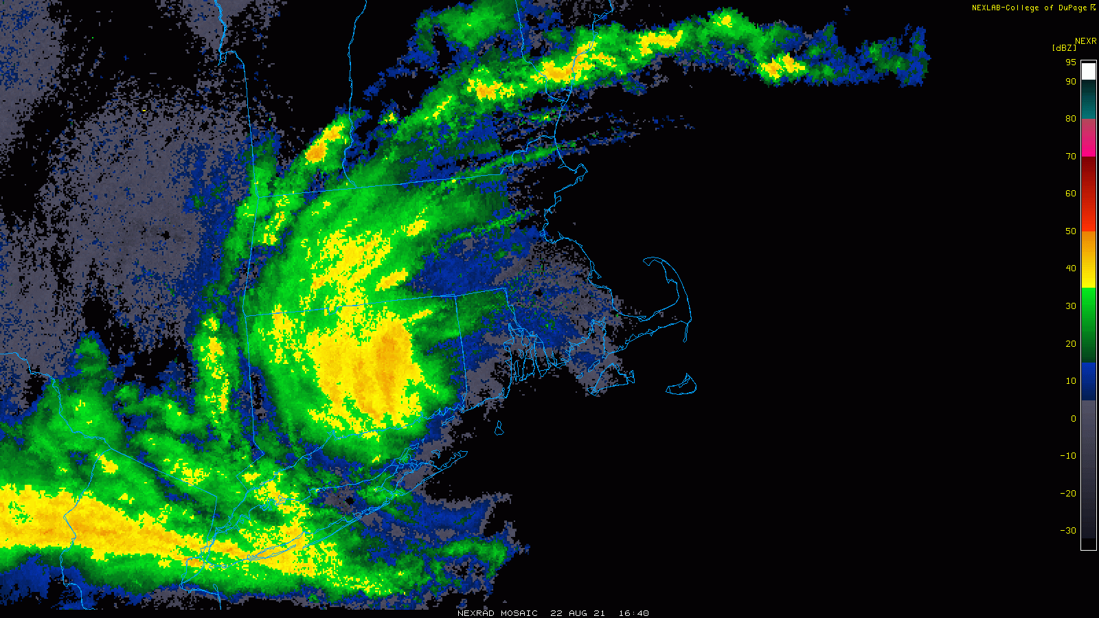
What’s left of Henri will slowly make its way eastward across the region today. It will be a warm and humid day, with some break of sunshine possible, especially early on. Showers and thunderstorms will redevelop, and some of them may produce heavy downpours. As was the case a few days ago when the remains of Fred moved through, a couple of spin-up tornadoes aren’t out of the question. If any of these do form, they’ll be short-lived and fairly weak, but can cause damage in their immediate vicinity. As for the rainfall, the heaviest rain will likely fall from western New England across southern New Hampshire, just to the north of the track of the low. This is consistent with what we normally see with tropical systems up in this neck of the woods, with most of the rainfall to the left of the track. That was certainly the case yesterday, with little rainfall across eastern Massachusetts after the initial band went through in the morning.
Some locally heavy rainfall is possible across the region today, especially from southern New Hampshire into western Massachusetts. Image provided by Weathermodels.com
Everything finally pulls away overnight, then high pressure builds in for Tuesday through Thursday with warm to hot and humid conditions. Temperatures will be well into the 80s each afternoon with some lower 90s possible. Dewpoints will also be in the upper 60s and 70s across the region, so it will feel quite oppressive. A cold front will bring an end to the heat and humidity late Thursday, but there is a chance that it may not come through until Friday, which would result in another warm to hot and humid day. High pressure builds in with cooler and drier conditions for Saturday. We may start to warm up again next Sunday as another warm front approaches the region.
Much more comfortable air should settle into the region next weekend. Image provided by WeatherBell.
Monday: More clouds than sunshine with some showers and thunderstorms likely, especially during the afternoon. High 77-84.
Monday night: Mostly cloudy with showers and storms ending, some clear may develop late at night. Low 65-72.
Tuesday: Becoming partly to mostly sunny and humid. High 81-88.
Tuesday night: Clear to partly cloudy. Low 65-72.
Wednesday: Sunshine and some afternoon clouds, humid. High 83-90.
Thursday: A mix of sun and clouds, humid, with showers and thunderstorms possible during the afternoon and evening. High 85-92.
Friday: Partly sunny, a few showers and thunderstorms are possible. High 79-86.
Saturday: Intervals of clouds and sun, much cooler. High 70-77.
5:00 PM – We’re shutting down the live coverage for the day. Our Weekly Outlook will be published as usual early Monday morning, where we’ll have more info on the remains of Henri and the rainfall threat across eastern New England. Thank you for following along today!
4:55 PM – All coastal warnings have been discontinued. Tropical Storm henri now has 40 mph sustained winds and is centered about 20 miles southeast of Hartford, Connecticut, moving toward the west-northwest at 7 mph. Winds are still gusting to 30-40 mph in spots, mainly along the coast, but they should continue to diminish over the next few hours.
At this point, the forecast remains unchanged. What’s left of Henri will eventually stall out over western New England, then what’s left will head eastward across central New England on Monday. Heavy rain continues tonight from northern New Jersey and eastern New York into western New England, gradually shifting eastward on Monday. Rainfall totals of 5-10 inches are likely in parts of Connecticut, western Massachusetts and eastern New York, with some totals of up to 12 inches in northern New Jersey. Flooding will be spread spread across this area. On Monday, rainfall totals of up to 2 inches are possible from eastern Massachusetts into southern New Hampshire and southern Maine.
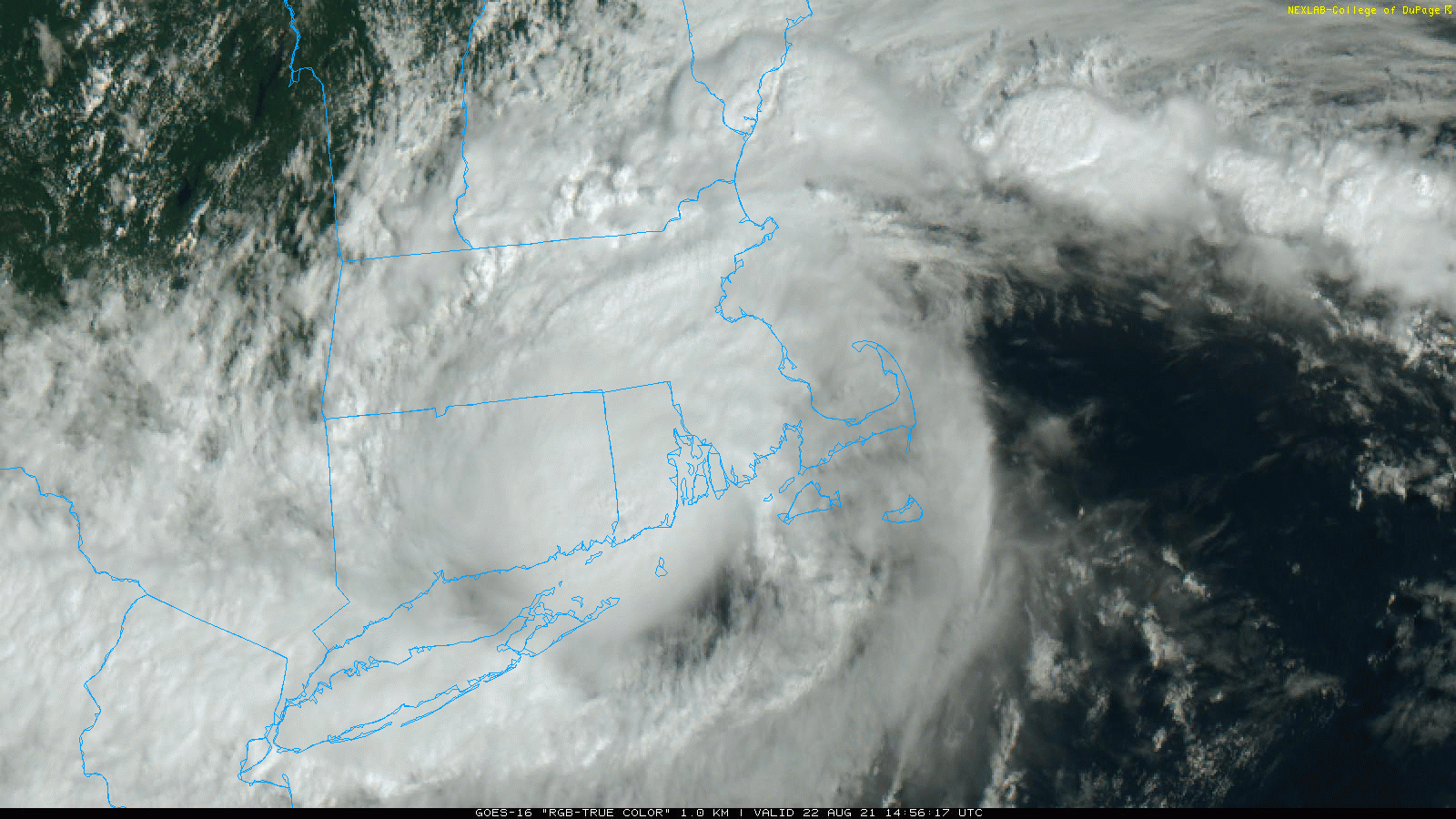
Radar loop of Tropical storm Henri. Loop provided by the College of DuPage.
3:15 PM – As Henri continues to push into Connecticut, if you’re in eastern Massachusetts you wouldn’t even know that there’s a tropical storm centered 100 miles to the west. Some breaks of sunshine are developing, and temperatures are in the 70s. It’s still quite breezy, in fact Blue Hill Observatory recently had a wind gust to 47 mph, but otherwise, it’s just a warm, humid, and breezy afternoon. The rain will move back into this region on Monday as what’s left of Henri heads eastward.
Satellite loop showing Henri making landfall in RI and then heading into CT while some breaks of sun develop in eastern MA. Loop provided by the College of DuPage.
2:00 PM – Henri continues to push inland and weaken. It is now centered over southeastern Connecticut and is moving toward the northwest at 9 mph. Maximum sustained winds are down to 50 mph, and additional weakening is expected for the rest of the day. Wind gusts of 30-40 mph are still being observed along the coasts of Rhode Island and Massachusetts, but they should subside over the next few hours. Heavy rain continues to push across much of Connecticut and western Massachusetts. Flash Flood Warnings are in effect for a good portion of the region.
The heavy rain continues to push into Connecticut and western Massachusetts. Loop provided by Weathermodels.com
12:15 PM – Henri has officially made landfall close to Westerly, RI with maximum sustained winds near 60 mph. There have been several reports of wind gusts of 60-70 mph along the coast of Rhode Island and Massachusetts already. Winds are still gusting as high as 45-55 mph or more in places. We’ve passed the morning high tide, and with the center moving inland, the water levels should start to subside through the afternoon as the tide rolls out. There is still a concern for some coastal flooding during the high tide cycle this evening. Wind damage will still be a concern though the afternoon from southeastern Massachusetts across Rhode Island and into eastern Connecticut.
At this point, the concern shifts to heavy rain. Additional rainfall totals of 3-6 inches and locally heavier are likely over the next 24 hours across Connecticut, eastern New York, and western Massachusetts. As what’s left of the storm drifts eastward on Monday, some heavy rain is possible in parts of southern New Hampshire and Massachusetts.
Concern now shifts to heavy rain across parts of the region. Image provided by WeatherBell.
11:30 AM – Looks like Henri is just about to make landfall along the southern Rhode Island coast. A wind gust to 70 mph was reported in Point Judith, RI, with an unofficial report of a gust to 76 mph on a hand-held anemometer in Point Judith.
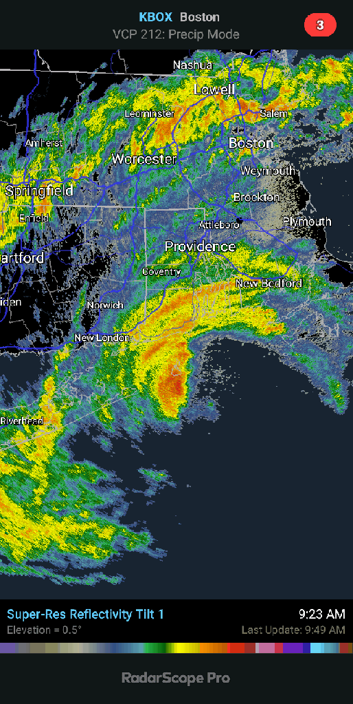
Radar shows Henri’s center just about at the Rhode Island coast. Loop provided by WeatherTap.
11:00 AM – Tropical Storm Henri now has maximum sustained winds near 60 mph. After crossing Block Island, Henri is centered about 15 miles east of Montauk, NY, moving toward the north-northwest at 12 mph. Landfall is expected along the Rhode Island coast in the next few hours. Tropical Storm Warnings remain in effect from central Long Island to Cape Cod. A sustained wind of 51 mph with a gust to 69 mph was reported in Point Judith, RI within the past few minutes.
Radar shows Henri taking on the classic signature of a tropical system impacting New England with most of the rain to the left of the center. Loop provided by Weathermodels.com
Once inland, Henri will continue northwestward while rapidly weakening, stalling out overnight, before heading eastward on Monday. Heavy rain will continue across parts Connecticut, eastern New York, and western Massachusetts tonight, shifting into parts of southern Vermont, southern New Hampshire, northern Massachusetts and southern Maine on Monday. Flood Watches are in effect for parts of this region.
10:35 AM – The pressure has started dropping on Block Island again, and has now bottomed out at 989mb but is starting to rise a bit. Sustained winds of 44 mph have been recorded on the island recently. There are also an increasing number of wind damage reports showing up from the south coast of both Rhode Island and Massachusetts.
Once Henri finally pulls away on Monday – hot and humid weather will return for a few days as the cleanup begins. High temperatures will be well into the 80s with some lower 90s possible.
Warm to hot and humid weather returns for Tuesday through Thursday. Image provided by weathermodels.com
10:10AM – The pressure appears to have bottomed out at 992mb on Block Island. Meanwhile, in Massachusetts, a wind gust to 62 mph was reported in Westport. A coastal flood advisory has also been issued for the east-facing shoreline of the Bay State. A storm surge of 1-3 feet on top of the astronomical high tides will result in some flooding today, especially the high tide around midnight tonight, and in the usual places such as Scituate and Morrissey Boulevard in Dorchester.
9:50 AM – The center of Henri is moving across Block Island. Sustained winds as high as 50 mph and a peak gust to 68 mph have been reported from the island.
Radar shows the center moving across Block Island. Loop provided by RadarScope
9:30 AM – A wind gust to 63 mph has been reported on Block Island. The initial outer band moved across Southern New England over the past few hours, producing up to 0.75″ of rain in a short period with some wind gusts to 20-30 mph. This pales in comparison to the band that moved across New York City last night that produced flooding across the Tri-State area.
In addition to being the wettest day since 2014… the 1.94" of rain that fell from 10pm to 11pm at Central Park last night was the wettest hour on record for New York City.
More rain fell in that one hour than any other since record keeping began. #Henri#NYCwx
9:00 AM – Tropical Storm Henri is now centered about 70 miles south of Providence. Maximum sustained winds have decrease to near 65 mph as Henri continues to weaken over colder waters. Water temperatures south of New England are 21-24C, well below the 27C threshold that tropical systems need to sustain themselves. Sustained winds of 47 mph and a wind gust to 59 mph have been reported on Block Island. The airport in Block Island is reporting North-Northeast winds at 33 mph with a gust to 55 mph. The automated station at the entrance to Buzzards Bay is reporting sustained winds of 47 mph with a gust to 58 mph. Note – the anemometer for this station is at 25 meters above the sea, while the standard anemometer height is 10 meters, so winds will read a bit stronger than at sea level.
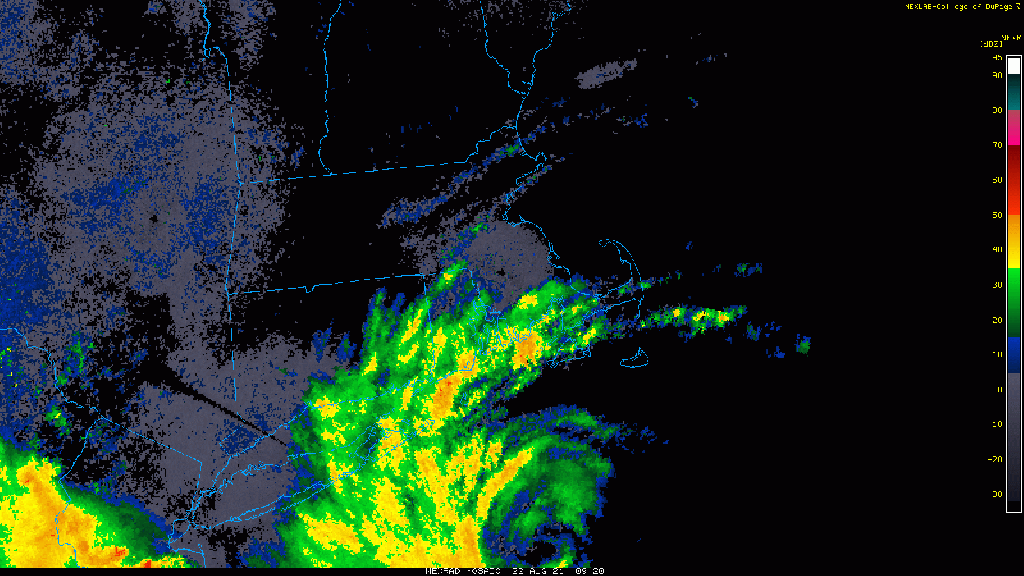
8:00 AM – Tropical Storm Henri is centered about 75 miles south of Providence, Rhode Island, moving toward the north-northwest at 16 mph. Maximum sustained winds have decreased to near 70 mph. Tropical Storm conditions are already spreading across southern New England and Long Island.
Henri’s bands are spreading across southern New England while the center shows up on radar to the south. Loop provided by the College of DuPage.
Wind gusts of 15-30 mph are already common across the region, with some gusts to 50 mph reported in southern Rhode Island. All Hurricane Warnings have been discontinued, but Tropical Storm Warnings remain in effect across the region.
Peak wind gusts expected across the region. Image provided by the National Weather Service office in Norton, MA
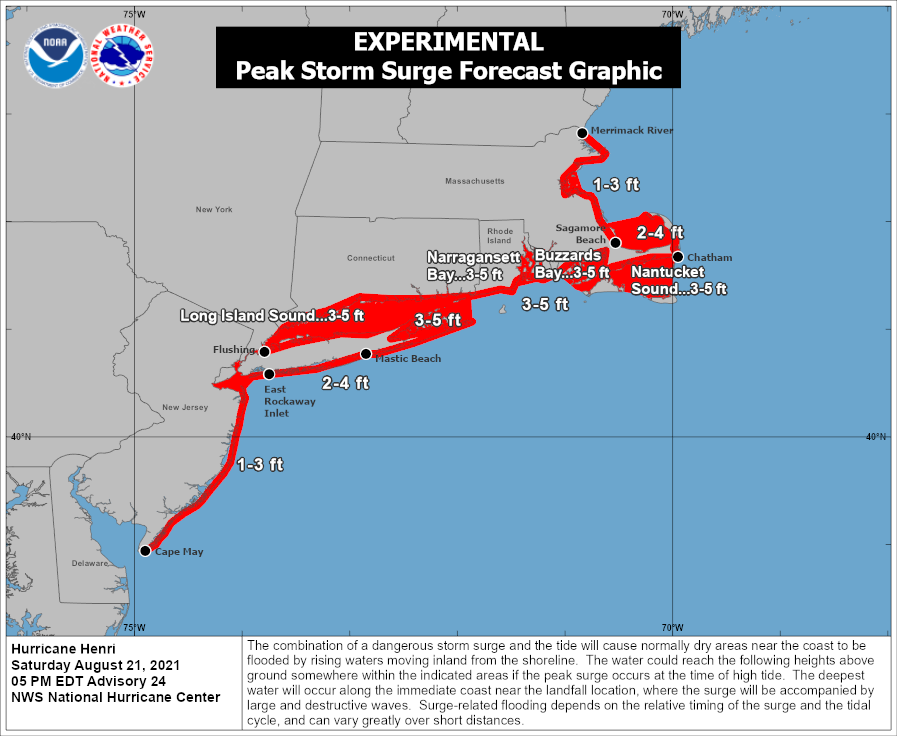
Henri should continue northward, likely making landfall in southern Rhode Island by early afternoon. Once inland, it will rapidly weaken, with heavy rain continuing west of the track, and gusty winds with occasional showers east of the track. There is also the threat for a few tornadoes east of the track. Along the coast, a storm surge of 3-6 feet is expected on top of astronomical high tides. Luckily, the high tides are this morning, with low tide in the middle of the afternoon, which will help offset the surge a little.
A storm surge of 3-5 feet is still expected along the coast. Image provided by the National Hurricane Center.
This will be only the 5th time since 1851 that New England/Long Island has had 2 landfalling storms in the same year, and only the 2nd time that both storms were tropical storm strength only:
1985 9/24 Tropical Storm Henri 9/27 Hurricane Gloria (Category 2)
2021 7/9 Tropical Storm Elsa 8/22 Tropical Storm Henri
Counting Elsa, 37 storms have made landfall in Long Island or New England as a tropical storm or stronger – an average of one every 4.6 years. The longest we’ve ever gone without a direct hit from a storm of tropical storm strength or stronger is 11 years, between 1897 and 1908, and again between 1923 and 1934. Elsa’s landfall earlier this year ended a 10-year drought without a landfalling storm.
Hurricane Henri continues to move up the East Coast with eastern Long Island or Rhode Island apparently in its sights for Sunday.
Satellite loop of Hurricane Henri. Loop provided by NOAA.
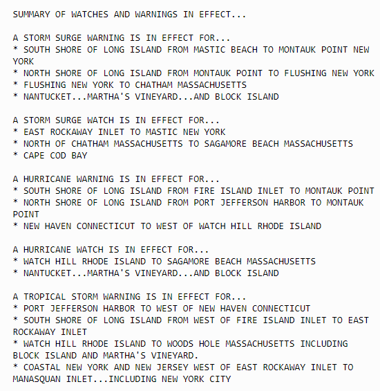
Henri strengthened into a hurricane this morning with maximum sustained winds near 75 mph. As of 5pm it was centered about 335 miles south of Montauk Point, Long Island, moving toward the north-northeast at 18 mph. A hurricane warning is in effect across central and eastern Long Island, and along the south coast of New England from New Haven, CT to Westport, MA, including Block Island. A Tropical Storm Warning is in effect west of New Haven to Manasquan Inlet, NJ, including western Long Island and New York City. A Tropical Storm Warning is also in effect east of Westport, MA to Chatham, MA, including Nantucket and Martha’s Vineyard. A Storm Surge Warning in effect from Flushing, NY to Chatham, MA, including most of Long Island, Block Island, Martha’s Vineyard, and Nantucket.
Forecast track for Hurricane Henri. Image provided by the National Hurricane Center.
There is a little more confidence in the forecast this afternoon, but still some some uncertainty. Henri is being steered north-northeastward by a ridge of high pressure to its east and a developing upper-level low over the Mid-Atlantic states. With less wind shear and warmer waters beneath it, Henri may strengthen a bit more over the next 6-12 hours while continuing northward. At that point, the question becomes – does Henri feel the influence of the upper-level low and bend northwestward, or does it continue off to the north? This will have significant implications to where it makes landfall and what conditions we can expect across the region. The current forecast from the National Hurricane Center has landfall Sunday afternoon near Montauk just below hurricane strength. The forecast models have shifted eastward a bit today, showing landfall anywhere from Central Long Island to as far east as Cape Cod. However, over the past 18 hours, the forecast models have trended a bit more to the east. Right now, our thinking is that landfall will be somewhere between extreme eastern Long Island and Narragansett Bay Sunday afternoon. With Henri weakening over colder waters as it approaches the coast, it will likely be a strong tropical storm at landfall, though there is a chance it could still be a minimal hurricane.
There is still a wide range of landfall possibilities among the various members of the GFS and ECMWF Ensembles. Image provided by Tomer Burg.
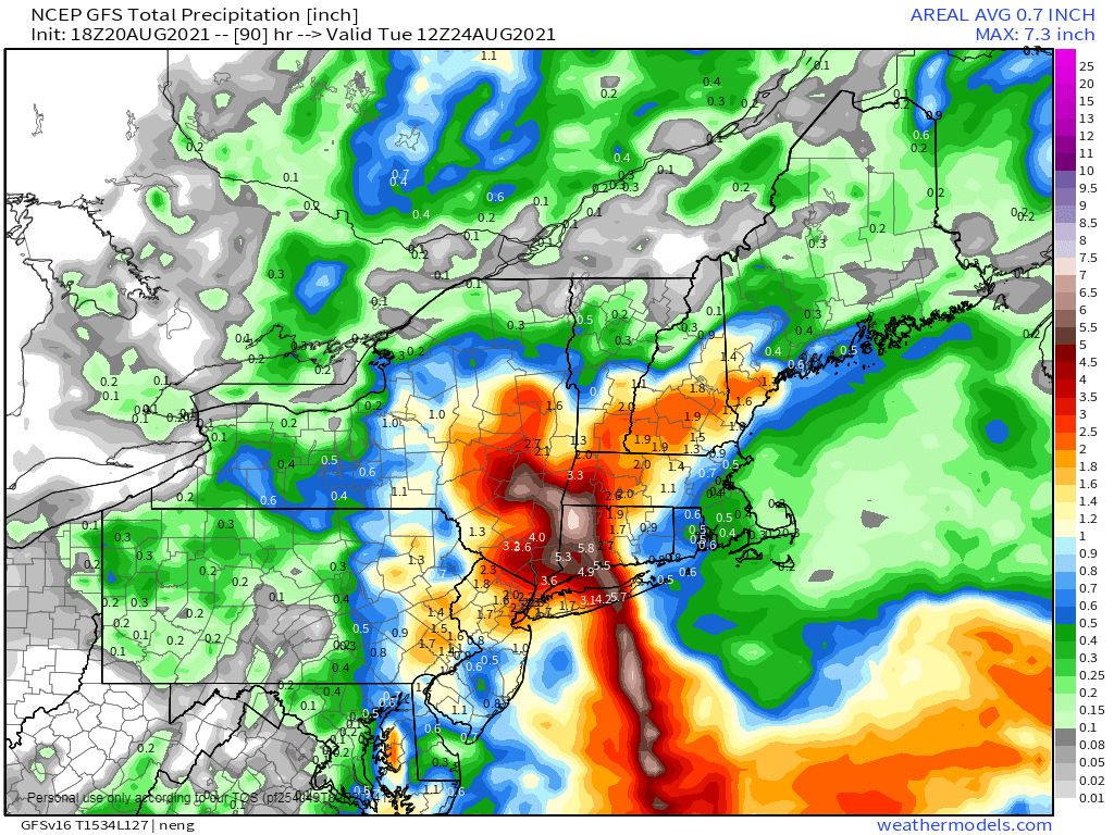
Once inland, Henri will rapidly weaken, but the track still will have an impact on the forecast. If it turns northwest, it will eventually stall out and then head eastward, but this will prolong the rainfall across the region, especially north and west of the track. Much of the region has received very heavy rain over the past 2 months. This has saturated the soil. As a result, some trees may be more susceptible than usual to winds of this strength, which may result in more widespread wind damage. The heavy rains will also lead to flooding, especially from western New England into parts of southeastern New York and Long Island.
Most of the models agree that the heaviest rain will be across western New England, southeastern New York, and Long Island. Images provided by Pivotal Weather.
To the east of the track, rainfall will just be spotty, with some gusty winds, mainly confined to coastal areas, where some gusts of 40-50 mph are possible. This is also where a storm surge of 3-5 feet on top of astronomical high tides will result in some coastal flooding, especially in parts of Rhode Island and southeastern Massachusetts. East of the track is also where we will need to keep an eye out for some short-lived tornadoes. Many landfalling tropical cyclones produce small tornadoes in the right-front quadrant of the storm. For a northward-moving storm like this, that means areas north and east of the center.
A storm surge of 3-5 feet may result in flooding from Long Island Sound to Cape Cod. Image provided by the National Hurricane Center.
Once Henri dissipates, the Atlantic looks a bit more quiet for now. However, we’re approaching the peak of hurricane season, so the quiet period likely won’t last that long.
Tropical Storm Henri has made the long-awaited northerly turn and now is heading towards New England or Long Island while Hurricane Grace has rapidly strengthened as it nears the coast of Mexico.
Satellite loop of Tropical Storm Henri. Loop provided by NOAA.
As of 11pm Friday, Tropical Storm Henri was centered about 615 miles south of Montauk, New York, moving toward the north at 9 mph. Maximum sustained winds were near 70 mph. Henri is expected to strengthen for the next 24 hours or so as wind shear begins to lessen and the storm remains over the warm waters of the Gulf Stream. Henri will likely become a hurricane on Saturday.
Watches and Warnings are in effect for a large portion of the Northeast coast. Image provided by the National Hurricane Center.
With a ridge of high pressure building in to the east of Henri, and an upper-level low pressure area developing over the Great Lakes, Henri will be steered northward for the next 24 hours, Beyond that, the upper-level low will start pull Henri northwestward and slow it down as it begins to approach Long Island or Southern New England. Since it will be over cooler water at that time, it will begin to weaken. Current forecasts show that Henri may still be a minimal hurricane at landfall, but there is also a good chance that it may weaken to a tropical storm by the time it reaches land.
The various members of the GFS and ECMWF Ensembles show landfall anywhere from New York City to Cape Cod. Image provided by Tomer Burg.
Although the exact track and intensity are still in question, the general impacts should be similar to most tropical systems that impact the Northeast. These systems tend to become lopsided, with the strongest winds mainly to the right of the center, and most of the rain shifting to the left of the track. The current forecast of a track towards eastern Long Island would mean that gusty winds and the highest storm surge would impact parts of Rhode Island and southeastern Massachusetts, including Cape Cod. The storm surge will be compounded by the fact that with a full moon on Sunday, tides will be astronomically high, exacerbating any storm surge flooding. The western track would also mean that the heaviest rain and greatest threat of freshwater flooding, would shift to Long Island, western portions of Connecticut and Massachusetts, and eastern New York.
Expected peak storm surge associated with Henri. Image provided by the National Hurricane Center.
While the winds won’t be particularly strong across much of Southern New England, tree damage could be more extensive that you’d normally expect. It has been a very wet summer across the region, with many places receiving 10-20 inches since the beginning of July. As a result, the ground is saturated across much of the area, so it won’t take strong winds to knock trees over. It also will result in more extensive flooding in areas that receive heavy rain.
Rainfall totals of 4-8 inches are possible where the heaviest rain falls. Image provided by Weathermodels.com
As the steering currents weaken late Sunday and Sunday night, Henri or what’s left of it, may stall out across western New England or eastern New York, then eventually start moving eastward, bringing more rain to parts of central and northern New England. Conditions will improve from west to east on Monday as the storm departs and high pressure starts to build into the region.
Satellite loop of Hurricane Grace. Loop provided by NOAA.
Meanwhile, in the Bay of Campeche, Hurricane Grace rapidly intensified into the Category 3 Hurricane this evening, with maximum sustained winds near 105 mph. As of 11pm, Grace was centered approximately 75 miles east-southeast of Tuxpan, Mexico, moving toward the west at 10 mph. A Hurricane Warning is in effect for the Mexican coastline from Puerto Veracruz to Cabo Rojo. Grace may strengthen a little more before it makes landfall in Mexico overnight, with storm surge and strong winds likely near the coastline. Rainfall totals of 6-12 inches and heavier will result in flooding and mudslides across the region.
Who’s ready for a nice quiet weekend weatherwise? Might I suggest a trip to Los Angeles then, because you’re not going to get one here, with or without Henri.
The remains of Tropical Storm Fred will continue to pull away this evening, but a few showers are still possible, otherwise, we’ll start to dry out a little overnight. However, warm and humid conditions will remain in place on Friday, with plenty of clouds and some sunny breaks, and possibly a few showers or thunderstorms. Saturday looks to be similar with some sunshine, but also some showers and thunderstorms possible as a warm and humid airmass remains in place. This brings us to Sunday and Monday, which is entirely dependent on the track of Henri.
Satellite loop of Tropical Storm Henri. Loop provided by NOAA.
As of 11am Thursday, Tropical Storm Henri was centered about 810 miles south of Nantucket, moving toward the west at 10 mph. Maximum sustained winds were near 70 mph. An Air Force Reconnaissance aircraft is investigating the storm right now to assess the true strength and structure of it. This should help improve the forecasts for the storm. Henri is fighting off some northerly wind shear as it moves around the edge of a ridge of high pressure, which is preventing it from strengthening. As it reaches the edge of the ridge tomorrow, it should turn more northward, and the shear will lessen. Combined with the fact that it will be over the warm waters of the Gulf Stream means that it should strengthen into a hurricane. As the same time, an upper-level low pressure area will develop over the Great Lakes, helping to steer Henri northward as well. This is where the largest uncertainty comes into play, and it has a giant impact on the forecast. Does the combination of the low to the west and ridge to the east remain strong and keeping Henri on a northward track, or does the ridge weaken a bit and allow Henri to turn more toward the northeast? If that wasn’t enough to complicate things, we also need to see how fast Henri is traveling at that point. The water off the Northeast coast is not warm enough to sustain a tropical system, so it will start to weaken. The faster it is moving, the less time it will have to weaken before reaching our latitude. These are questions that we can’t answer yet.
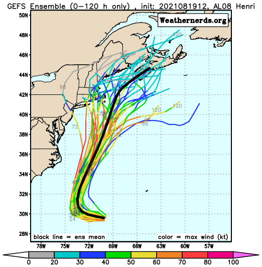
Forecast track for Henri from the various members of the GFS Ensemble. Image provided by Weathernerds.org
Since Henri formed, our thinking all along has been that it would pass close to or just south and east of Cape Cod, close enough for some impact across the Cape and Islands at least. That remains a plausible scenario. There are plenty of models that have landfall across Rhode Island or Southeastern Massachusetts as either a hurricane or strong tropical storm, and others that show no landfall and keep the storm offshore. Either way, it’s important to remember that as storms reach this latitude, they become lopsided, with most of the heavy rain to the left of the center, and the stronger winds confined to the right of the center. So, a track near or just off the Cape would spare most of the region from the strong winds, but result in heavy rainfall, especially across eastern Massachusetts. A track across southeastern Massachusetts would bring strong winds onto the Cape and Islands, and shift the heavy rain inland a bit more. The track will also impact the storm surge. With a full moon on Sunday, we’re already going to have astronomical high tides, which can create some coastal flooding on their own in spots. Add in a storm surge, and significant coastal flooding is likely, especially just to the right of the storm track. With all of these things possible, the National Hurricane Center will likely issue a Tropical Storm or Hurricane Watch for parts of the region on Friday.
Probability of tropical storm fore winds and the most likely arrival time. Image provided by the National Hurricane Center.
Most of the impacts from Henri are likely from Sunday afternoon into Monday morning, but again, this is dependent on the track and speed of the storm. Either way, conditions should start to improve Monday afternoon as Henri begins to pull away.
Thursday night: Partly to mostly cloudy, a few showers possible during the evening. Low 66-73.
Friday: Intervals of clouds and sunshine, chance for a shower or thunderstorm. High 79-86. Offshore: Southwest 10-15 knots, gusts to 20 knots seas 3-5 feet.
Friday night: Partly cloudy, patchy fog may develop. Low 66-73.
Saturday: Partly sunny, a few showers and thunderstorms are possible in the afternoon. High 81-88. Offshore: Southeast 5-10 knots, seas 2-4 feet.
Saturday night: Mostly cloudy. Low 65-72.
Sunday: Cloudy and becoming breezy with some showers developing, possibly becoming a steadier and heavier rain late in the day. High 72-79. Offshore: Tropical storm conditions likely
Sunday night: Breezy to perhaps windy with rain, possibly heavy. Low 62-69.
Monday: Diminishing winds with rain tapering off to showers and ending, some sunny breaks may develop in the afternoon. High 74-81. Offshore: Tropical storm conditions likely, subsiding late in the day.
What’s left of Tropical Storm Fred is dumping heavy rain on parts of the Mid-Atlantic states this afternoon, but there are still two active tropical systems in the Atlantic, and both could cause significant problems.
Satellite loop showing Hurricane Grace south of Cuba and Tropical Storm Henri southwest of Bermuda. Loop provided by NOAA.
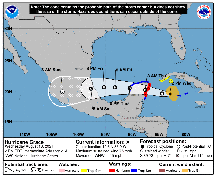
Hurricane Grace is the more immediate threat. As of early Wednesday afternoon, Grace was centered about 295 miles east of Tulum, Mexico, moving toward the west-northwest at 15 mph. Maximum sustained winds were near 75 mph. A Hurricane Warning is in effect for eastern portions of the Yucatan Peninsula, with a Tropical Storm Warning for other portions of the Yucatan as well as the Cayman Islands.
Forecast track for Hurricane Grace. Image provided by the National Hurricane Center.
Grace’s forecast is fairly straightforward. It should strengthen a bit more today and tonight before making landfall in the Yucatan early Thursday. It should weaken a bit over land, then move back into the Bay of Campeche late Thursday. It will likely strengthen again, likely regaining hurricane status before a second landfall in Mexico late Friday or early Saturday between Veracruz and Tampico. Strong winds, torrential rainfall that will lead to flooding and mudslides, and storm surge flooding are all expected across the region.
Grace will bring torrential rainfall to parts of Mexico over the next several days. Image provided by WeatherBell.
Grace produced heavy rain and flooding over the past several days from the Leeward Islands across Puerto Rico and the Virgin Islands, into Hispaniola, Jamaica, the Cayman Islands, and parts of Cuba. Rainfall totals of up to 10 inches were observed in some areas. While winds haven’t been a huge factor thus far for much of the region, wind gusts exceeded 50 mph on Jamaica, with some gusts to near hurricane force reported in the Cayman Islands this morning as Grace pulled away.
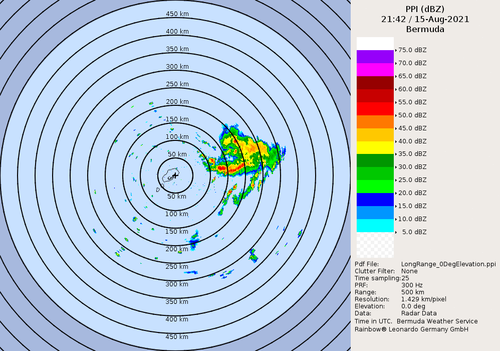
While Grace is preparing to slam into the Yucatan, all eyes here in New England are focused on Tropical Storm Henri. As of early Wednesday afternoon, Henri was centered about 190 miles southwest of Bermuda, or 795 miles south-southeast of Nantucket, moving toward the west at 8 mph. Maximum sustained winds were near 65 mph. Some slow strengthening is expected, and Henri could become a hurricane over the next few days.
Radar from Bermuda shows Henri’s path around the islands. Loop provided by Brian McNoldy, University of Miami, Rosenstiel School
Henri’s future track is highly uncertain at this point. With a ridge of high pressure to the north and east, it should continue westward for the next day or so before it reaches the western edge of the ridge and begins to turn northward. At the same time, an upper-level low pressure area will begin to develop over the Great Lakes. These two features will combine to send Henri up the East Coast, but that’s where the uncertainty really begins. Some models have Henri continue moving around the ridge and turning northeastward, either heading out to sea or possibly impacting parts of Atlantic Canada. Some models have the upper low strengthen a bit more and the ridge build back in, allowing Henri to keep heading north, possibly even turning toward the northwest like Sandy did, which would result in landfall across New England or Long Island. Given that this is still around 4 days or so away from any potential impact, it is just too early to tell which scenario is more likely. Either way, residents of Southern New England should keep a close eye on Henri’s progress.
The various members of the GFS Ensemble show the wide range in potential tracks for Henri. Image provided by Tropical Tidbits.
With the forecast as it is, and knowing how the media can be, we are issuing an Extreme Hype Watch for the region. An Extreme Hype Watch is issued when conditions are favorable for media hype of an event to reach extreme levels within the next 48-72 hours. If conditions warrant, a Hype Advisory or Extreme Hype Warning will be issued as the event draws nearer.
Tomorrow marks 30 years since Hurricane Bob made landfall near Newport, Rhode Island. The 30 years is the 2nd longest we’ve ever gone without a hurricane landfall in New England or Long Island.
Since 1851, a hurricane has made landfall in New England or Long Island 18 times, an average of one every 9.4 years. The longest we’ve ever gone between hurricane landfalls is 38 years, between 1896 and 1934. It’s been 30 years since Bob, our 2nd longest drought on record. (Of the 18 hurricanes that made landfall in New England or Long Island since 1851, 15 of them have done so between August 19 and September 27.)
Since 1851, 9 hurricanes of Category 2 intensity or stronger have made landfall in New England or Long Island, an average of one every 18.9 years. The longest we’ve gone between hits by storms of that intensity is 69 years, between 1869 and 1938. We’re at 30 years since Bob, the last one to do so.
Since 1851, New England/Long Island has had 3 Major Hurricanes (Category 3 or higher) make landfall – an unnamed storm in October of 1869, the infamous 1938 Long Island Express, and Hurricane Carol in 1954. That’s an average of 1 every 56.7 years, and the longest time between 2 major hurricanes is 69 years (1869-1938). We’re at 67 years since Carol. There are also 3 documented storms from before 1851 – The Great Colonial Hurricane of 1635, the 1815 New England Hurricane, and the Norfolk and Long Island Hurricane of 1821. That’s it. That changes the numbers to 6 in 386 years, or one every 64.3 years, with a longest drought of 180 years.
Satellite photo of Hurricane Bob approaching New England. Bob was the last hurricane to make landfall in New England – 30 years ago. Image provided by NOAA.
There is some history involving New England and the two current names, Grace and Henri. In 1991, Grace was a hurricane off the East Coast in late September. As it moved northward, it was absorbed by a much larger extratropical system which eventually started moving south and then southwest off the coast of New England. This became the “No-Name Halloween Storm”, or as the book and movie were later titled – ‘The Perfect Storm”. Grace was a new addition to the name list in 1991, as the previous “G” storm had its name retired. That storm was Gloria in 1985, which slammed into Long Island on September 27. As for Henri, it also hit New England in 1985, a few days before Gloria. Most people don’t remember it for two reasons. First, it was very weak – it weakened to a tropical depression right at landfall near Westerly, Rhode Island on September 24 and rapidly dissipated. It did not produce much rain or wind across the region. Second, all eyes were on the much more powerful Hurricane Gloria which was starting to move up the East Coast
There are now three active systems in the Atlantic and two more in the Pacific. All but one are a threat to land.
Satellite loop showing Fred nearing the Florida Panhandle, Grace over Haiti, and TD 8 near Bermuda. Loop provided by NOAA.
The most immediate threat is Tropical Storm Fred. After sputtering over Cuba this past weekend, Fred emerged into the eastern Gulf of Mexico and has become better organized. As of early Monday afternoon, Fred was centered about 35 miles southwest of Apalachicola, Florida, moving toward the north at 10 mph. Maximum sustained winds have increased to 65 mph. Tropical Storm Warnings and Storm Surge Warnings are in effect for parts of the Florida Gulf Coast. Fred may strengthen a little more before it makes landfall late this afternoon or evening. Once inland, it should rapidly weaken. The main threats from Fred are strong winds, heavy rain, and storm surge, along with the possibility of a few tornadoes.
Radar shows the center of Fred approaching the Florida Panhandle. Loop provided by Weathermodels.com
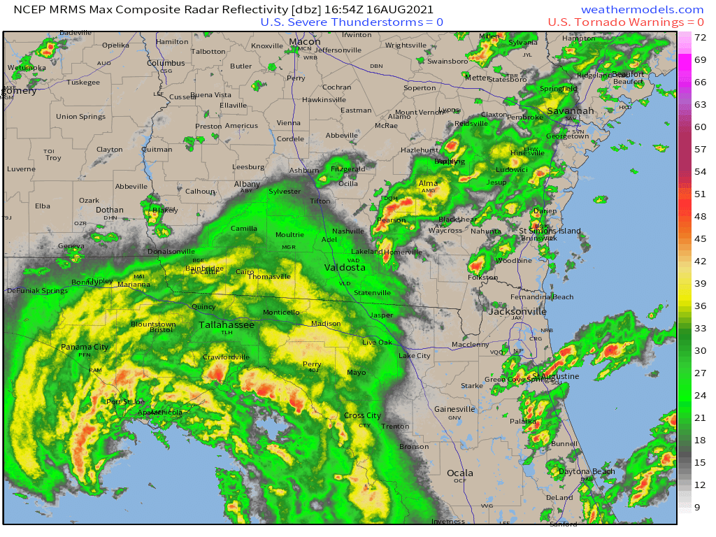
Fred will produce 4-8 inches of rain across parts of Florida and southern Georgia, with some locally heavier amounts. As it moves inland and weakens, the moisture will start to interact with a frontal system, bringing heavy rain to parts of the Southeast, Mid-Atlantic States, and the Appalachians. In these areas, rainfall totals of 3-6 inches and locally heavier will likely lead to flooding over the next few days.
Forecast models show the potential for heavy rain from the Southeast into the Mid-Atlantic states. Images provided by Pivotal Weather.
While Fred heads for Florida, Grace may be starting to get its act together near Haiti Grace brought heavy rain to parts of the northeastern Caribbean this weekend, but was very poorly organized. It looks a bit healthier this afternoon as it nears the south coast of Haiti. It was centered about 70 miles southeast of Port-au-Prince, Haiti early Monday afternoon, moving toward the west-northwest at 12 mph. It is still a tropical depression with maximum sustained winds near 35 mph. A Tropical Storm Warning is in effect for parts of southern Cuba and the Cayman Islands, while Tropical Storm Watches are in effect for Haiti, Jamaica, and parts of southern Cuba.
Grace is expected to continue on a general westward course for the next several days. As it pulls away from Haiti late tonight, it will move over the warm waters of the northwestern Caribbean, and gradual strengthening is expected. The current forecast calls for it to be a strong tropical storm as it approaches the northern Yucatan Peninsula in a few days. Beyond that, a track into the Gulf of Mexico seems likely at this point.
Forecast track for Tropical Depression Grace. Image provided by the National Hurricane Center.
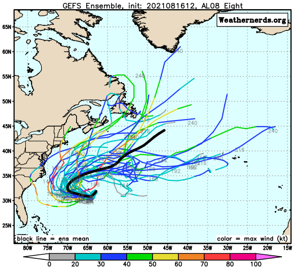
Out in the central Atlantic, Tropical Depression Eight developed late Sunday night. As of early Monday afternoon, it was centered about 140 miles southeast of Bermuda, moving toward the south at 9 mph. Max sustained winds were near 35 mph. A Tropical Storm Watch is in effect for Bermuda. The system is expected to become a tropical storm later today or tonight as it turns westward and rides around a ridge of high pressure. Eventually, it will turn back to the north and northeast and head out into the open Atlantic. There is a slight chance that it could impact the East Coast, depending on how quickly it makes the turn. It should bring some rough seas to the coastal waters from the Carolinas to New England later this week.
Forecast track for Tropical Depression Eight from the various members of the GFS Ensemble. Image provided by Weathernerds.org.
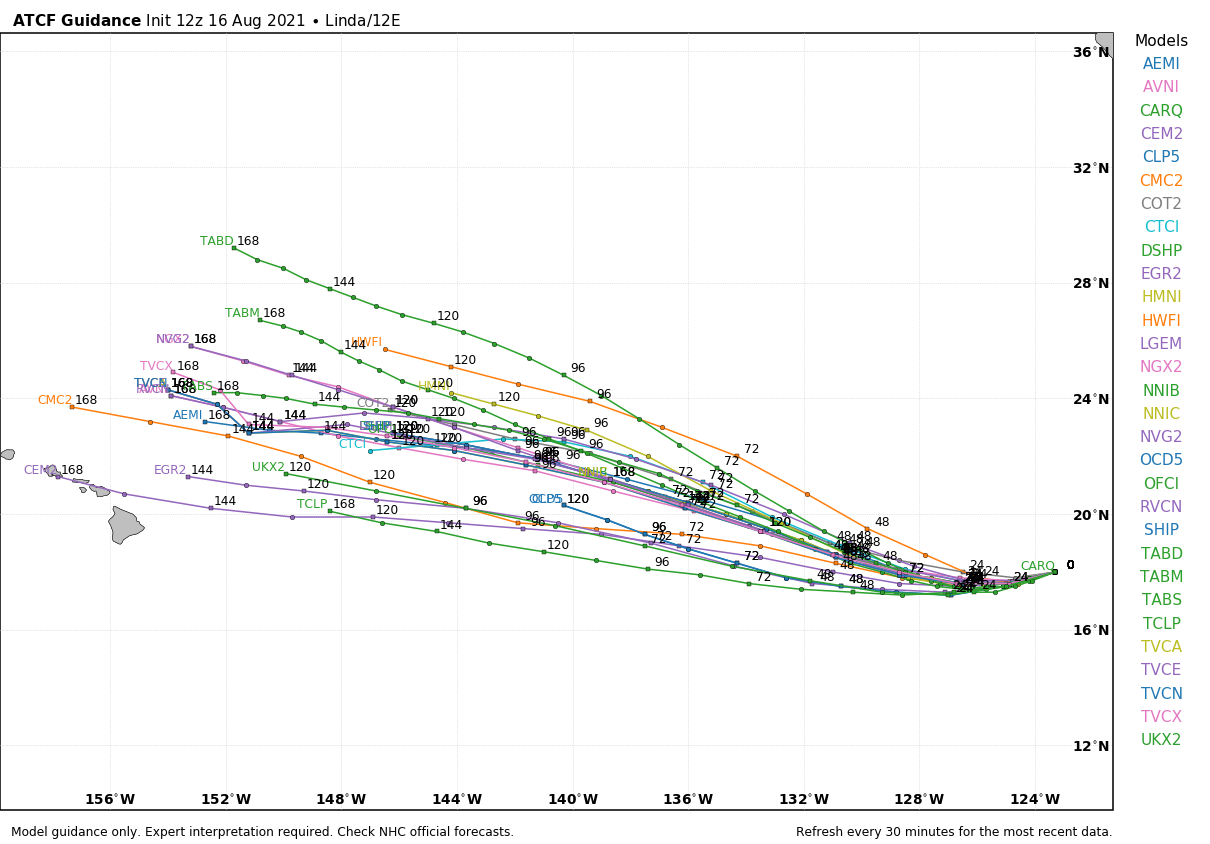
In the Eastern Pacific, Hurricane Linda still has maximum sustained winds near 105 mph at midday. It was centered about 955 miles west-southwest of Cabo San Lucas, Mexico, and moving toward the west-southwest at 9 mph. Linda reached Category 4 strength over the weekend, but now is gradually weakening over open water. It should continue on a general west to west-northwest track this week while slowly weakening. It should pass well north and east of Hawaii late this week as a weakening extratropical system, with little impact other than some rough surf.
Model forecasts for the track of Hurricane Linda. Image provided by WeatherBell.
Out in the Western Pacific Ocean, Tropical Depression 16W remains fairly weak. It has maximum sustained winds near 25 mph, and is centered about 180 miles east of Guam, moving toward the west at 18 mph. It will bring heavy rain and some gusty winds to the Northern Mariana Islands over the next day or so as it passes very close to Guam.
Forecast track for Tropical Depression 16W. Image provided by the Join Typhoon Warning center.
The system may start to strengthen once it gets past the Northern Marianas and turns a bit more toward the northwest. Some forecasts call for it to become a tropical storm, and possibly a typhoon by the end of the week. Where it will go is highly uncertain at this point. While the official forecast from the Joint Typhoon Warning Center has it heading towards Taiwan, various models have it continuing westward to the Philippines, continuing west-northwestward toward Taiwan and/or eastern China, or turning northward and heading toward Japan. It will have to be watched closely later this week.
We’ve got a nice start to the week with seasonably warm temperatures and low humidity, but changes are coming once again.
After the heat and humidity of last week, much more comfortable air settled in late Saturday, and it will remain in place Tuesday thanks to a large high pressure area. However, as that high slides offshore later on Tuesday southwest winds will start to send humidity levels rising again, but that’s just a taste of what is coming.
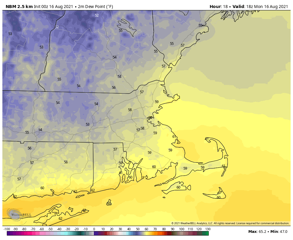
Dewpoints will be in the 50s and lower 60s this afternoon. Image provided by WeatherBell.
Much of the remainder of the week looks warm (but not hot) and quite humid, but also unsettled. High pressure will remain anchored offshore, pumping the humid air into the region. Although it will be warm, it won’t be hot, because we’ll actually have plenty of cloudcover at times, along with a daily chance for showers and thunderstorms. Eventually some of the moisture from Fred (more on the tropics down below) should get in here, enhancing the rainfall. We’re not quite going back to our record-breaking wet pattern from July, but some parts of the region could pick up a decent amount of rain during the latter half of the week. The day with the most uncertainty is Sunday, which could end up drier and cooler if a cold front drops southward across the region.
Some of the models show a decent amount of rain between now and Saturday. Images provided by Pivotal Weather.
As for the tropics, there are now three systems in the Atlantic that we’re watching. Tropical Storm Fred is expected to make landfall in the Florida Panhandle late tonight or early Tuesday as a strong tropical storm, though it wouldn’t be a surprise if it somehow became a hurricane before landfall. It should rapidly weaken once inland. Tropical Depression Grace is expected to remain weak as it passes close to or over Hispaniola and Cuba over the next few days, assuming it even survives the trip. If it does, it could start to strengthen as it gets into the Gulf of Mexico later this week. Finally, we have Tropical Depression Eight, which formed near Bermuda late Sunday night. It will bring some squally conditions to Bermuda over the next day or two, and should gradually strengthen, but right now, doesn’t look like it’ll impact any other land areas. We’ll have a much more detailed look at the tropics later today in another blog post.
There are three tropical systems to keep an eye on in the Atlantic. Image provided by the Canadian Hurricane Centre.
Monday: Sunshine and some high clouds. High 75-82.
Monday night: Partly cloudy. Low 57-64.
Tuesday: Partly sunny. High 78-85.
Tuesday night: Partly to mostly cloudy. Low 64-71.
Wednesday: Plenty of clouds with a few showers or thunderstorms possible. High 77-84.
Thursday: Mostly cloudy with scattered showers and thunderstorms. High 77-84.
Friday: Clouds and some sunny breaks with more showers and thunderstorms possible. High 76-83.
Saturday: Intervals of clouds and sunshine, with a few showers or thunderstorms around. High 78-85.
Sunday: Partly sunny, chance for more showers and thunderstorms. High 76-83.
Finally, we’ll leave you with this thought. In Montana, temperatures are likely going to top 100 across central and eastern parts of the state today, and again tomorrow. Then a strong cold front is going cross the region later Tuesday and Wednesday. Behind that front, temperatures will be 40-50 degrees cooler than the day before. Oh, but the temperature drop isn’t the only concern. Take Helena, MT for example. The GFS has a forecast high of 96 in Helena today. Tomorrow night, that same model is forecasting a low of 34, accompanied by 5″ of snow.