We’ve got another complicated forecast coming up for the start of the weekend, but the end isn’t complicated at all.
In between the wildfire smoke to the north and east, and all the moisture to the south, we’ve actually got a rather nice day in progress. Loop provided by NOAA.
High pressure will remain in place across southeastern Canada through the weekend. An upper-level low will move from the Great Lakes toward the Northeast, keeping us on the cool side through Saturday. A disturbance rotating around that low will help spawn a low pressure system off the Mid-Atlantic coastline, where there is still plenty of moisture hanging around, some of it being the remains of Ophelia. While the low should stay well to our south, a trough extended from the low towards southern New England will help draw some of that moisture northward, generating plenty of clouds tonight and Friday. The question becomes, how far north does the rain get, and how heavy will it be. There is still a lot of disagreement among the models, but based on the trends in the models and their known biases, we’re thinking that most of the rain will be south of the Mass Pike, with the steadiest and likely heaviest rain mainly south of Route 44. It wouldn’t be a surprise if no rain falls at all from the Merrimack Valley into southern New Hampshire. The rain winds down Saturday morning, and we may see some clearing by late in the day. After that, high pressure builds back in for Sunday and Monday with sunshine and warmer temperatures.
The models still don’t agree on how much rain much of our area will see tomorrow and Saturday. Images provided by Pivotal Weather.
Thursday night: Becoming mostly cloudy, patchy fog may develop once again. Low 46-53.
Friday: Mostly cloudy with showers developing, mainly south of the Mass Pike. High 60-67.
Friday night: Cloudy with periods of rain and showers, mainly south of the Mass Pike. Some of the rain could be heavy near the South Coast. Low 50-57.
Saturday: Showers ending around midday, some breaks of sun possible by late afternoon, especially from the Merrimack Valley northward. High 62-69.
Drier weather is on the way, but the week will start off cool and wet.
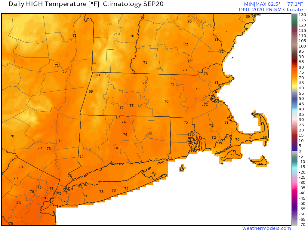
Normal high temperatures for the end of September are in the upper 60s. Image provided by Weathermodels.com
The remains of Tropical Storm Ophelia will pass south of the region today, with more clouds, some rain showers, especially south of the Mass Pike, and mainly through early afternoon, and breezy conditions, due to the gradient between what’s left of Ophelia and the large high pressure area well to the north. An upper-level low swings through on Tuesday with more clouds, and possibly a few showers,, but most of us will remain dry. High pressure then builds in for the rest of the week and the weekend with dry and seasonably cool conditions. There will be some disturbed weather hanging around to the south during the end of the week and the weekend, but for now at least, it looks like the high pressure area should keep us dry.
We need to keep an eye on some moisture associated with a disturbance that should remain south of the region at the end of the week. Images provided by Pivotal Weather.
Monday: Cloudy breezy, and cool with more showers, mainly south of the Mass Pike, tapering off in the afternoon. Some sunny breaks may develop by late afternoon in southern New Hampshire. High 58-65.
Monday night: Partly to mostly cloudy, a few lingering showers near the South Coast. Low 48-55.
Tuesday: Intervals of clouds and sun, slight chance for a shower. High 58-65.
Tuesday night: Becoming clear to partly cloudy. Low 42-49, a little milder near the coast from Boston southward.
We’ve got a rather complicated forecast coming up as we officially end astronomical summer and begin fall with the autumnal equinox at 2:50am Saturday.
Fall officially begins early Saturday morning. Image provided by CBS News.
High pressure to our north will keep us dry and seasonably cool into Friday. However, high clouds will begin to stream northward from what is currently being called “Potential Tropical Cyclone 16”, but will likely be named Ophelia soon. Whether it is tropical or subtropical doesn’t have much impact on the forecast. Future Ophelia will likely strengthen a bit before moving into eastern North Carolina early Saturday.
Forecast track for Potential Tropical Cyclone 16. Image provided by the National Hurricane Center.
As our high pressure system moves off to the east, southerly flow will send the rain up the East Coast. This is where things get tricky, because another high pressure area will also be trying to build in from the northwest. We’ve seen this setup many times before, and what usually happens is that the high wins out and keeps most of the rain (or snow in the winter) off to our south. However, anytime there’s been a chance for rain this summer, we’ve ended up with a lot of rain. So, taking both of those ideas into account, here’s what we think will happen:
The rain will move up the coast on Friday and Friday night, but will have a tough time moving in early Saturday with plenty of dry air in place. Eventually, the rain will win out, overspreading the region during the afternoon. How far north it gets is still a big question, and it wouldn’t be a surprise to us if the rain never made it across the MA/NH border. Some of the rain may be heavy during the late afternoon and evening, especially south of the Mass Pike. The rain may taper off for a while Saturday night and early Sunday as the second high tries to build in, and the low to the south moves up into the Mid-Atlantic states. A second batch of showers is possible later Sunday and Sunday night as the low starts to turn more toward the northeast, eventually passing out to sea south of New England on Monday, with some additional showers possible.
Heavy rain is likely across parts of the region this weekend, but how far north is still in doubt. Images provided by Pivotal Weather.
Thursday night: Clear skies, though some high clouds will start to move in. Low 47-54.
Friday: Sunshine filtered through high clouds in the morning, clouds thicken up in the afternoon. High 65-72.
Friday night: Mostly cloudy. Low 49-56.
Saturday: Showers developing from south to north during the late morning and early afternoon, becoming a steady and potentially heavy rain by late afternoon. High 58-65 during the morning, temperatures drop into the 50s during the afternoon.
Saturday night: Rain tapers off to showers during the evening, mostly cloudy overnight. Low 49-56.
Sunday: Plenty of clouds, some showers may redevelop during the afternoon. High 60-67.
Sunday night: Cloudy with showers likely. Low 50-57.
Monday: Mostly cloudy, more showers around, especially during the morning. High 61-68.
Another rainy Monday is on the way, but much of the upcoming week will feature dry weather.
A frontal system will move into the region today while an area of low pressure develops off the Mid-Atlantic coastline. The low will ride up the front, passing close to or across southeastern New England later today. The result will be periods of rain and showers through the day today, some of which could be heavy at times. Some localized flooding is possible in spots, but we should have any flooding to the magnitude we saw last Monday. Everything winds down tonight as the system pulls away, then high pressure builds in with dry and seasonably mild conditions for Tuesday through Friday and probably Saturday as well.
The models are all forecasting heavy rain across the region today. Images provided by Pivotal Weather.
Late Saturday and Sunday is when things get complicated again. Low pressure will begin to develop off the Southeast coast later this week. As our high pressure system moves off to the east, moisture from the low to the south will start to head northward, and may result in some wet weather around here for Saturday night and Sunday. The forecast models don’t all have the same timing and evolution of this system, so we’ll likely be refining this part of the forecast when we get to our Weekend Outlook on Thursday.
Normal high temperatures for late-September are in the lower 70s.
Monday: Periods of rain and showers, some of the rain may be heavy at times. High 64-71.
Monday night: Showers ending, then areas of fog develop. Low 54-61.
Tuesday: Becoming mostly sunny and breezy. High 68-75.
Tuesday night: Clear skies. Low 50-57.
Wednesday: Plenty of sunshine. High 69-76.
Thursday: Sunshine and a few clouds. High 68-75.
Friday: A mix of sun and clouds. High 68-75.
Saturday: Intervals of clouds and sun, rain possible at night. High 65-72.
Sunday: Mostly cloudy with a chance of showers. High 65-72.
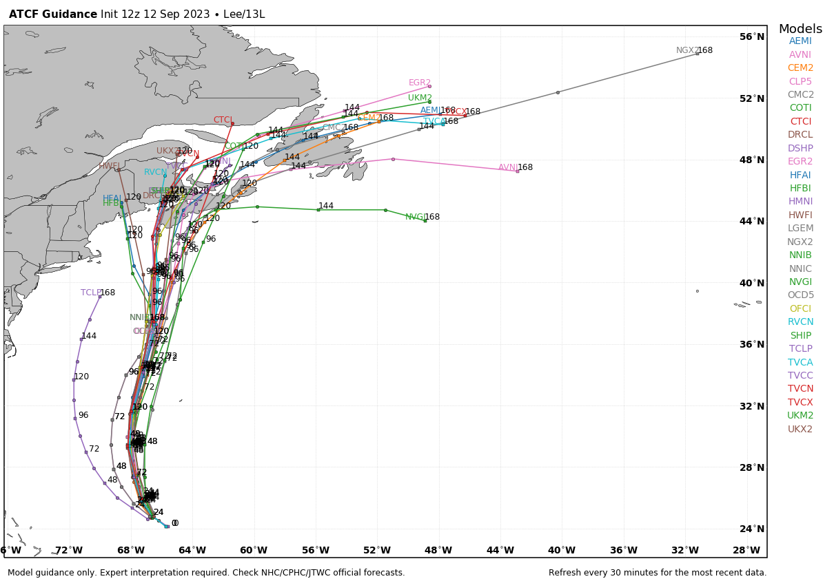
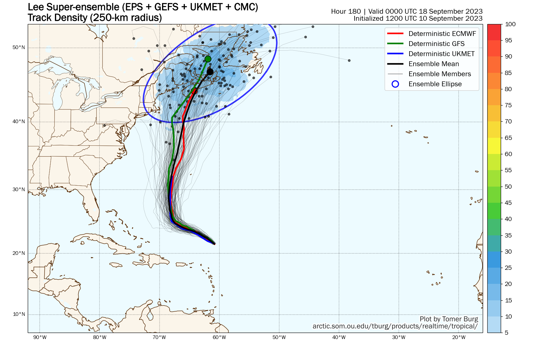
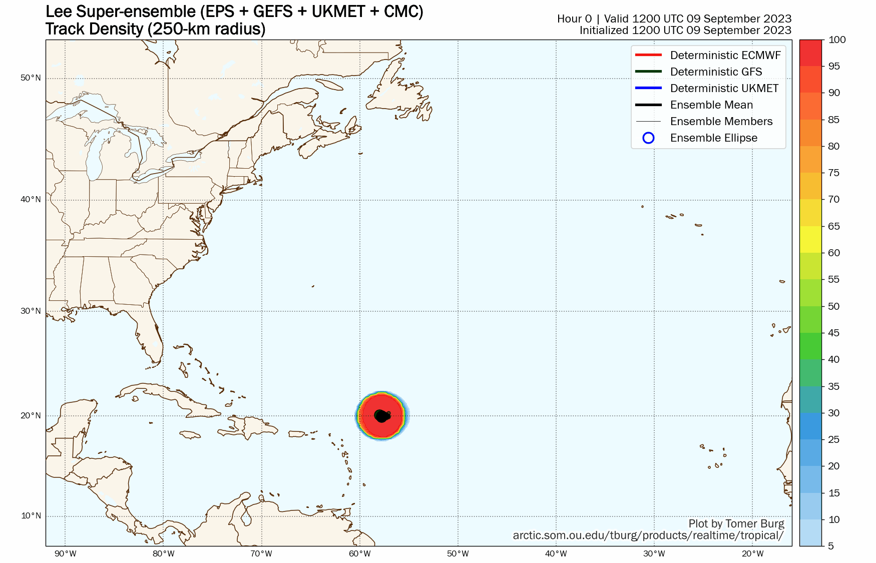
All eyes are on Hurricane Lee and what impact it will have on the region over the next few days.
Lee is passing well west of Bermuda this afternoon. Loop provided by NOAA.
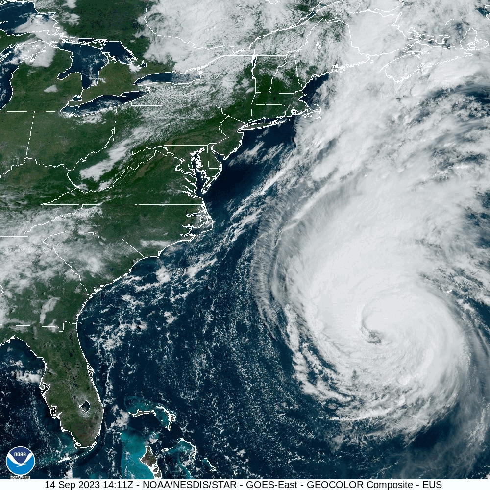
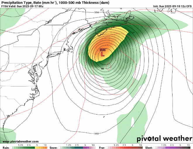
Hurricane Lee was centered about 710 miles south of Nantucket at 2pm, moving toward the north at 14 mph. Maximum sustained winds were near 85 mph. A Tropical Storm Warning is in effect for Cape Cod and the Islands as well as coastal Plymouth County, with a Tropical Storm Watch for the rest of Massachusetts and Rhode Island, as well as the Seacoast of New Hampshire and the southern Maine coastline. A Storm Surge Watch is also in effect for Cape Cod Bay and Nantucket. Lee will continue northward for the next 24 hours, gradually weakening as it feels some increasing wind shear and starts to move over cooler waters. A slightly bend toward the northwest is possible late Friday as an upper-level low moves into southern Canada, but it should eventually start to turn more toward the northeast, likely becoming extratropical as it makes landfall in Nova Scotia at tropical storm strength.
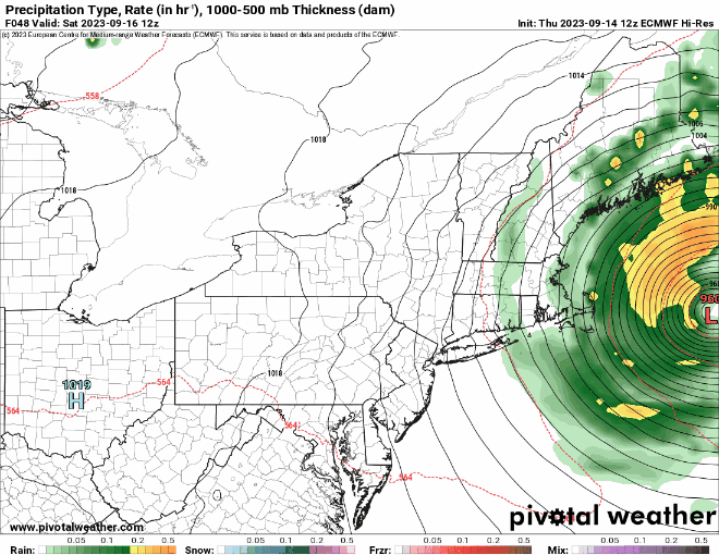
Most of the models keep Lee well east of the region, with rain mostly along the coast Saturday morning. Images provided by Pivotal Weather.
High clouds ahead of Lee will stream into the region tonight, and they will thicken up on Friday as winds start to increase as the pressure gradient between and a high pressure area to our northwest tightens up. The worst of the storm will be between Midnight and about Noon on Saturday. Most of the rain will be confined to Cape Cod and the immediate coastline, with just a few showers penetrating farther inland. With northeast to northerly winds, eventually become northwest Saturday afternoon, the only places where storm surge will be an issue is north-facing shorelines, where the Storm Surge Watch is in effect. While large waves will batter the coastline for the next few days, a storm surge of 2-4 feet above the normal tides will impact the north shore of Cape Cod and northern Nantucket. As for those winds, we’re looking at sustained winds of 30-50 mph for parts of Cape Cod and the Islands with gusts to 60 mph or more, and 20-30 mph sustained winds near the eastern Massachusetts coast with gusts of 40-50 mph possible. Farther inland, winds will be a little weaker than that. Overall, Saturday will be a windy day, with some rain mainly near the coast, something we’ve experienced hundreds, if not thousands, of times. In the grand scheme of things, this is not a big deal for 95% of our region.
Peak wind gusts will generally be in the 35-45 mph range for most of the region, except for the Cape and Islands. Image provided by WeatherBell.
Once Lee starts to pull away, skies will clear out Saturday night and winds will start to diminish, setting up a fantastic Sunday with sunshine and warm temperatures. Clouds will start to move back in by evening as a weak disturbance starts to approach from the west. That system may produce a few showers on Monday, but temperatures will remain mild.
Thursday night: Increasing clouds. Low 51-58.
Friday: Mostly cloudy, becoming breezy. High 65-72.
Friday night: Cloudy and windy with showers developing near the coast, some steadier and heavier rain across Cape Cod. Low 54-61.
Saturday: Windy with rain and showers ending around midday, skies may start to clear out late in the day. High 65-72.
Saturday night: Clearing with diminishing winds. Low 53-60.
Sunday: Sunshine and some afternoon clouds, still breezy in the morning. High 72-79.
Sunday night: Becoming partly to mostly cloudy. Low 55-62.
Monday: Intervals of clouds and sun with a chance for a few showers. High 71-78.
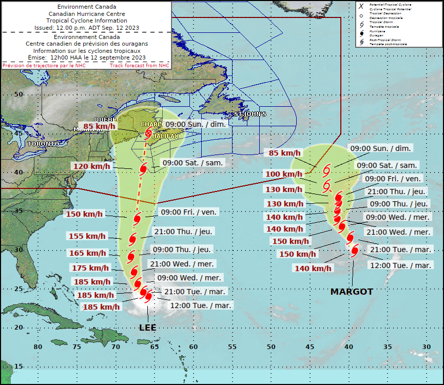
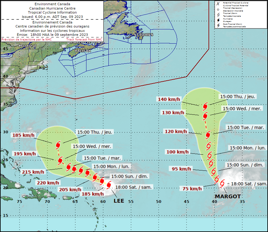
Lee and Margot both remain hurricanes over the Atlantic this afternoon, but the future of both is a little more certain than it had been just a few days ago.
Hurricanes Lee and Margot continue to make their way across the Atlantic. Image provided by Environment Canada.
As of 11am, Hurricane Lee was centered about 555 miles south of Bermuda moving toward the west-northwest at 6 mph. Maximum sustained winds were near 115 mph. Lee is expected to turn more toward the northwest and eventually north over the next day or so as it reaches the western edge of a ridge of high pressure. This will bring the storm west of Bermuda, but because it is relatively large, strong winds will likely impact the island later Thursday and early Friday, a Tropical Storm Watch has been issued. Sustained winds of 40-50 mph are expected, with some gusts to 70 mph.
Hurricane Lee is passing well north of Puerto Rico this afternoon. Loop provided by NOAA.
Lee will steadily weaken beginning Wednesday as it starts to move over cooler water and also feels the impacts of increasing wind shear. It should continue northward for the next few days, likely starting to transition into an extratropical system by later Friday. While the storm will be weakening, likely down to tropical storm strength, the wind field will be expanding, as it becomes an extratropical system. There is still one bit of uncertainty with the track. Another upper–level trough of low pressure will be moving into the Northeast. Will this pull Lee northwestward for a time on Friday, keep it heading northward toward Nova Scotia, or turn it more toward the northeast. Either way, Nova Scotia and nearby New Brunswick are likely to bear the brunt of Lee, with strong winds, heavy rain, and rough surf with some coastal erosion. Gusty winds and heavy rain are also likely across parts of eastern Maine, but here in southern New England, aside from the rough surf that we’ll have most of the week, impacts will be limited to gusty winds and some rain, mainly right along the coast, especially across Cape Cod. Sustained winds of 20-40 mph gusting to 60 mph at times are possible across the Outer Cape and Nantucket.
Most of the models are now homing in on a track toward Nova Scotia. Image provided by WeatherBell.
Well to the east we have Hurricane Margot. As of 11am, Margot was centered about 890 miles southwest of the Azores, moving toward the north at 12 mph. Maximum sustained winds were near 85 mph. Margot may strengthen a bit more over the next day or so, but after that, a steady weakening trend should commence. Margot will continue northward for the next couple of days, but after that, steering currents will become a bit weaker, so Margot’s future is a little more uncertain. It is not a threat to any land areas at this time, so whether it continues northward or turns a bit more toward the northwest, it will only impact shipping interests and marine life.
Hurricane Margot remains over open water this afternoon. Loop provided by NOAA.
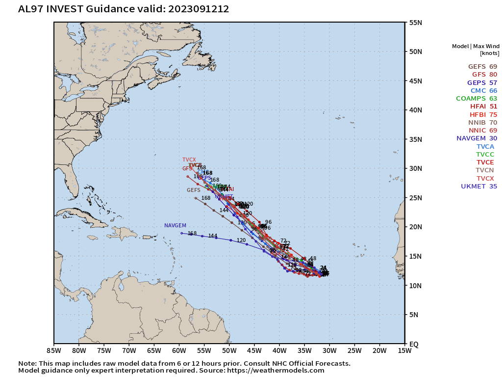
We’re also keeping an eye on an area of disturbed weather located over the eastern Atlantic ocean. It’s producing disorganized showers and thunderstorms right now, but conditions could be favorable for some development over the next few days. If it continues to develop, it could spawn a tropical depression by this weekend. It is not a threat to any land areas at this time, and most of the forecast models show it heading northwestward into the open Atlantic.
The next disturbance shouldn’t impact any land areas for at least the next week or so. Image provided by Tropical Tidbits.
Elsewhere, the tropics remain quiet, with no active systems anywhere in Pacific, and none expected for the next several days.
Remember that weather pattern we had for most of the summer where it seemed to rain nearly every day? Yeah, it’s back for the first half of this week.
Some spots could pick up more heavy rain today. Image provided by Weathermodels.com
A frontal boundary remains stalled out nearby, meaning another day with warm and humid conditions along with showers and thunderstorms, some of which will produce heavy downpours. The front finally pushes offshore tonight, with some slightly drier air settling in for Tuesday. However, there will still be some moisture around, so cloudcover will be prevalent, but showers will be few and far between. A stronger cold front moves in on Wednesday, with more showers and thunderstorms likely, again some could be heavy, during the day Wednesday and into Wednesday night, ending early Thursday. High pressure builds in behind the front with drier and cooler conditions later Thursday into Friday. The weekend forecast will be dictated by the track that Hurricane Lee eventually takes.
Where will Lee be on Saturday? The answer to that question has a big impact on the forecast. Images provided by Pivotal Weather.
As of 11pm, Hurricane Lee, with maximum sustained winds near 120 mph, was centered about 690 miles south-southeast of Bermuda, moving toward the northwest at 8 mph. Lee may strengthen a little more over the next day or so as it continues northwestward. By mid-week, it should be turning northward as a trough of low pressure moves off the East Coast. Lee will also begin weakening as wind shear starts to increase again and it moves over cooler water that was brought to the surface in the wake of Hurricane Franklin. The question becomes – what does Franklin do at the end of the week? Does the combination of another trough of low pressure at upper levels and the high building in at the surface help to steer Lee more toward the northeast, toward Atlantic Canada or even out to sea, or does it keep Lee on a northward track, bringing in much closer to New England? The former is still the more likely scenario, but there are enough models showing the latter, or at least something similar, that it can’t be ruled out just yet. One thing is fairly certain, once Lee gets this far north, it will be much weaker than it is now, likely only tropical storm strength, but it could also be undergoing the start of a transition into an extratropical system. If there are to be any impacts across New England this weekend, they’d be most likely near the coast, with heavy rain the main threat. High surf is likely for much of the week along our shoreline no matter the track that Lee takes.
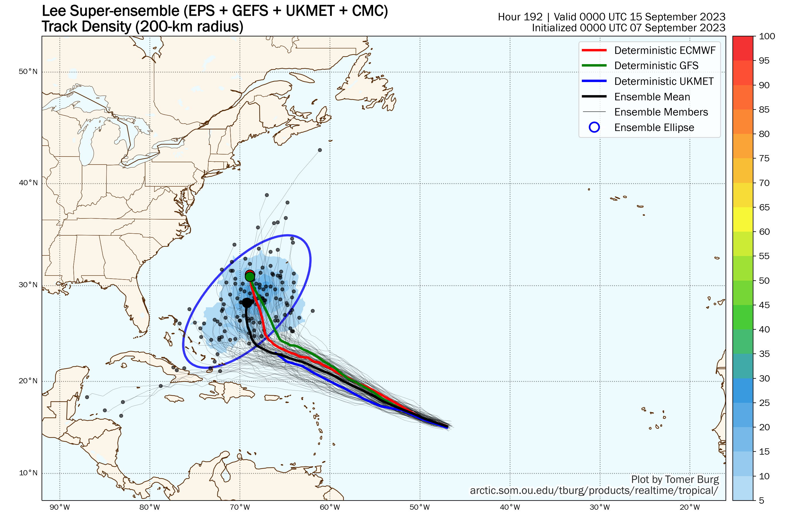
The vast majority of the ensemble members still keep Lee well offshore of New England. Image provided by Tomer Burg.
Tropical Storm Margot continues to slowly strengthen in the eastern Atlantic. As of 11pm Sunday, Margot had top winds near 65 mph, and was centered about 1185 miles west-northwest of the Cabo Verde Islands, moving toward the north at 8 mph. Margot should continue northward while strengthening for the next few days, likely reaching hurricane strength. By later in the week, high pressure building in to the north may slow Margot down, but it should remain over open water for much of the week.
Forecast track for Tropical Storm Margot. Image provided by the National Hurricane Center.
We also need to keep a close eye on a tropical wave that just moved off the west coast of Africa. Conditions will be favorable for development as it makes its way across the Atlantic. If it continues to organize, it could become a tropical depression later this week. While it is still at least a week away from potentially impacting any land areas, some models show the potential for this system to continue developing into next week.
Monday: More clouds than sun with showers and thunderstorms developing, some could produce heavy rainfall. High 74-81.
Monday night: Mostly cloudy, showers ending, areas of fog likely. Low 62-69.
Tuesday: Intervals of clouds and sun, just a chance for a stray shower or two. High 72-79.
Tuesday night: Partly to mostly cloudy. Low 62-69.
Wednesday: Mostly cloudy, showers and thunderstorms developing, again some could be heavy. High 72-79.
Thursday: Showers ending early, becoming partly sunny. High 70-77.
Friday: Partly sunny, breezy. High 67-74.
Saturday: Intervals of clouds and sun, chance for showers, especially near the coast, breezy. High 65-72.
Hurricane Lee and Tropical Storm Margot continue to slowly move across the Atlantic Ocean this evening.
Neither Hurricane Lee nor Tropical Storm Margot should impact land over the next 3-5 days. Image provided by Environment Canada.
Hurricane Lee has generated plenty of hype over the past several days, and will continue to do so into next week. As of 5pm Saturday, Lee was centered about 310 miles northeast of the Northern Leeward Islands, moving toward the west-northwest at 10 mph. After peaking as a Category 5 hurricane a couple of days ago some shear has taken its toll on Lee, reducing maximum sustained winds down to 115 mph. Lee should continue west-northwestward for the next day or two, passing safely north of the Greater Antilles, but generating some rough surf. The rough surf will spread to Bermuda and the East Coast over the next couple of days as well. Southwesterly shear is forecast to continue for another day or so (possibly longer), which means that rapid restrengthening is not likely. In fact, it wouldn’t be a surprise if Lee weakened a little more despite passing over very warm waters.
Despite the weakening, Lee remains a formidable hurricane over open water. Loop provided by Tropical Tidbits.
By the beginning of the upcoming week, Lee will turn more toward the northwest and then north as an upper-level trough of low pressure moves off the East Coast. Exactly where it makes the turn will be the key to determining if Lee will have any impact on land. Historically, the odds are strongly against that happening already. Lee has already moved north of 20 degrees North latitude before reaching 60 degrees West longitude. A colleague did some research on this and found that over the past 30 years, storms that pass north and east of that 20/60 point have just a 14% chance of making landfall in the United States.
Historically, tropical cyclones of any strength that are located where Lee currently is have a less than 5% chance of making landfall in New England. Image provided by Florida State University,
Lee should head northward, passing west of Bermuda, but possibly close enough to bring tropical storm conditions to the island. After that, another upper-level trough will be moving into the eastern U.S., and the position and strength of that trough will be crucial in determining whether Lee turns northeastward and heads out to sea, or continues northward towards Atlantic Canada. Yes, there is still a small chance that Lee impacts eastern New England, especially Maine, but the odds of this happening are very low at this point. When it does get this far north, whether it heads out to sea or into Atlantic Canada (or New England), it absolutely will NOT be as strong as it is now. In fact, there’s a very good chance it might not even be hurricane strength at that point. It also could be undergoing transition into an extratropical system. Bottom line, there’s a better chance of the Patriots winning the Super Bowl this season than there is of Lee ending New England’s hurricane drought, currently at 32 years and counting.
The overwhelming majority of the ensemble members do not show a threat to the Eastern US over the next week. Loop provided by Tomer Burg.
Farther to the east lies Tropical Storm Margot. As of 5pm, Margot was centered about 1020 miles west-northwest of the Cabo Verde Islands, moving toward the northwest at 9pm. Maximum sustained winds were near 45 mph. Margot is also undergoing some wind shear right now, but it should lessen as Margot turns more toward the north over the next day or so. Margot should start to strengthen, and could become a hurricane by early in the week. Margot should continue northward over open water, without impacting and land areas over the next several days.
Forecast track for Tropical Storm Margot. Image provided by the National Hurricane Center.
Another tropical wave has also moved off the west coast of Africa. Some of the models show the potential for this wave to develop, so we’ll keep a close eye on it as it makes its way across the Atlantic over the next several days.
While the heat will fade away over the next few days, the humidity won’t, and there’s some rain in our future as well. Meanwhile, we’ve got Hurricane Lee and a new Tropical Depression in the Atlantic.
Temperatures will average 5-10 degrees above normal for the next few days. Image provided by WeatherBell.
High pressure will move offshore and sit there for the next several days while a frontal system very slowly moves eastward from the Great Lakes. In between the two, southerly winds will keep us warm and rather humid right through the weekend. We’ll have a little more cloud cover over the next few days, which will keep temperatures a little lower, but still likely into the 80s each afternoon for many locations. A few showers or thunderstorms are possible during the next few afternoons and evenings, but most of them should stay north and west of our area. Sunday and Monday is the more likely timeframe for showers and thunderstorms to develop around here, as the cold front will finally be approaching our neighborhood. Sunday is the home opener for the Patriots, so a lot of people are interested in that forecast. While there will likely be some showers and possibly thunderstorms around, whether they will impact the game (or the tailgating) is a little tough to pin down at this point, so if you’re heading to Foxborough, best to plan for it, but hope it doesn’t materialize. Temperatures will likely be in the upper 70s at kickoff, and it will be quite humid.
Many of the models have some showers around at the time of kickoff on Sunday. Images provided by Pivotal Weather.
Thursday night: Increasing clouds, patchy fog developing, slight chance for a shower during the evening from southern New Hampshire into central Massachusetts. Low 66-73.
Friday: Partly sunny, a shower or two possible during the afternoon, mainly from southern New Hampshire into central Massachusetts. High 83-90.
Friday night: Partly to mostly cloudy. Low 67-74.
Saturday: Intervals of clouds and sun, a few showers possible into the afternoon, mainly north and west of I-495. High 79-86.
Saturday night: Mostly cloudy, chance for a shower or two. Low 66-73.
Sunday: More clouds than sun with some showers and thunderstorms likely, mainly north and west of I-95. High 76-83.
Sunday night: Mostly cloudy with some showers around, mainly during the evening. Low 64-71.
Monday: Partly to mostly cloudy with scattered showers and thunderstorms likely. High 75-82.
Hurricane Lee was joined by Tropical Depression 14 this afternoon. Image provided by the National Hurricane Center.
Hurricane Lee will be grabbing headlines for the next several days and rightfully so. As of 11am, Lee had maximum sustained winds near 105 mph, making it a Category Two hurricane. It was centered about 870 miles east of the Northern Leeward Islands, moving toward the west-northwest at 15 mph. There is little wind shear over Lee, and extremely warm waters that extend deep into the ocean, which means conditions are ideal for Lee to continue to rapidly strengthen, and the forecast from the National Hurricane Center calls for Lee to become a Category 5 hurricane with winds near 160 mph by Friday evening. Lee should continue on a west-northwest track, passing north of the Caribbean this weekend. After that, things get a little trickier. Lee will likely start to see its intensity fluctuate over the weekend as eyewall-replacement cycles begin to develop. As for its track, a west-northwest track will continue into the weekend, but it will start to slow down as it reaches the western edge of a ridge of high pressure. At this point, a turn more toward the northwest or north will likely develop. When that turn takes place will be key to the forecast next week. There has already been considerable hype on the internet about Lee threatening the East Coast next week. We’ll just say this. It is FAR too early to speculate on where Lee will be heading 7-10 days from now. Is there a chance Lee could threaten the East Coast or Atlantic Canada? Yes, there is, but it’s not a likely scenario at this point. Even if it does threaten the East Coast, it is not likely to be the Category 5 monster it will develop into this weekend.
Ensemble forecasts for the track of Hurricane Lee over the next week. Image provided by Tomer Burg
Meanwhile, Tropical Depression 14 has developed in the eastern Atlantic. As of 11am, TD 14 was centered about 160 miles west of the Cabo Verde Islands, moving toward the west-northwest at 17 mph. Maximum sustained winds were near 35 mph. The system is expected to steadily strengthen, likely become a Tropical Storm tonight or Friday, and possibly reaching hurricane strength over the weekend. The forecast calls for it to eventually turn more toward the northwest and north, staying over open water the entire time.
Forecast track for Tropical Depression 14. Image provided by the National Hurricane Center.
We’ll post a special blog about the tropics with a deeper dive into Lee’s future either Friday or Saturday.
Meteorological summer ended last Thursday. Pumpkin everything has arrived, college football has begun, the NFL starts the regular season this week, kids are back in school, Christmas stuff has even started showing up in stores. Summer is over, right? Astronomical summer doesn’t end until the autumnal equinox, which occurs at 2:49AM on September 23. Mother Nature will remind you this week that it’s still summer.
The forecast for the first half of the week is fairly simple. High pressure will remain in control with sunny days, warm to hot temperatures, coastal seabreezes, and increasing humidity. With the humidity, we’ll also have some patchy fog developing during the next few nights. Temperatures will get well into the 80s during the afternoons, with some spots topping 90, though coastal locations will likely drop into the 70s during the afternoons. The latter half of the week is where things get tricky.
Thursday looks quite toasty away from the coastline. Image provided by WeatherBell.
Thursday is likely to be another very warm to hot and humid day, but clouds will be moving in ahead of an approaching frontal system. Some showers and thunderstorms may move in late in the day, but it is just as likely that Thursday remains rain-free. Showers and thunderstorms look more likely on Friday, but temperatures will be highly dependent on the timing of the front. A frontal passage earlier in the day means cooler temperatures, but a later frontal passage could mean another day with temperatures topping 80. Some models don’t show the front moving through until Saturday, which could mean yet another warm day, but also more showers and thunderstorms. The front may stall out nearby, which means the unsettled weather could even linger into Sunday. With the Patriots set to open their season in Foxborough at 4:25pm next Sunday, fans are hoping for nice weather for the game itself and pregame tailgating.
The quest for a record 7th Lombardi trophy begins on Sunday.
Monday: Patchy morning fog, otherwise sunshine with a few afternoon clouds. High 82-89, cooler along the coast.
Monday night: Partly cloudy, areas of fog develop. Low 61-68.
Tuesday: Becoming mostly sunny. High 84-91, cooler along the coast.
Tuesday night: Clear to partly cloudy, patchy fog possible again. Low 65-72.
Wednesday: Mostly sunny. High 85-92, cooler along the coast.
Thursday: Morning sun, increasing afternoon clouds, showers and thunderstorms possible late in the day. High 87-94, cooler along the coast.
Friday: More clouds than sun with some showers and thunderstorms likely. High 81-88.
Saturday: Partly to mostly cloudy with a chance for more showers and thunderstorms. High 78-85.
Sunday: Intervals of clouds and sun, chance for another shower or two. High 75-82.
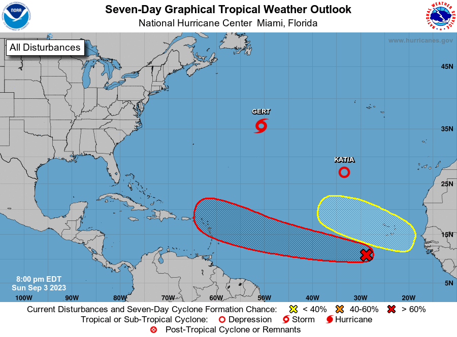
A tropical wave way out in the Atlantic has a high likelihood of becoming a tropical depression in the next few days. Image provided by the National Hurricane Center.
Finally, a word about the tropics. There is a tropical wave way out in the Atlantic that is slowly getting better organized. It could become a tropical depression in the next few days. It is at least 5 days away from potentially impacting the islands in the eastern Caribbean, if at all, and assuming it actually develops. There have been a few of the forecast models that have been showing that this storm could be a threat to the East Coast. At this point in time, that is pure hype and nothing else. These same models have done a horrible job forecasting actual tropical systems this season, let alone ones that haven’t even developed yet. Could this system impact the East Coast? Sure, anything is possible, but that’s a minimum of 8-10 days away from even potentially happening. This is not something you should be too concerned about at this point in time. If there is a time to be concerned, we’ll let you know well in advance. For now, ignore the hype.