Weekly Outlook: September 19-25, 2016

Do not panic! Water is going to fall from the sky today. This is actually a normal circumstance. We haven’t seen it happen that much in the past several months, but it does actually happen from time to time. There’s even a technical term for it – “Rain”.

We really need this rain, as the drought we’re in just keeps getting worse and worse. Much of the region is now in severe or extreme drought, and while today’s rain will help, it will barely put a dent in it. What we need is numerous episodes of rainfall spread out over time, and the chances of that happening should start to improve as we head deeper into fall and winter.

How much rain we get today is still a big question mark, as you can see by these two model forecasts. We could get a little, we could get a lot. At least we’ll get some rain. Of course, after today’s rain, we probably won’t see much more until a cold front comes through Friday night. Before that, we’ll have high pressure bringing us dry and warm weather once again. As for next weekend, once the front goes through, high pressure returns with more dry weather. Notice that we didn’t say more “dry and warm” weather. That’s because next weekend looks significantly cooler. How much cooler? How does highs in the 60s and lows in the 40s sound? It sounds like late September to us. While these temperatures are actually a little below normal, given how warm the past few months have been, it’ll feel like it’s a lot cooler than it really is.

20160913_northeast_trd
Latest drought update showing Severe to Extreme Drought across much of central and Southern New England. Image provided by US Department of Agriculture.

Monday: Cloudy with periods of rain and showers expected. Some localized downpours are possible. High 71-78.

Monday night: Mostly cloudy with rain tapering off and ending. Low 60-67.

Tuesday: Becoming partly to mostly sunny. High 78-85.

Tuesday night: Clear to partly cloudy.Low 57-64.

Wednesday: Sunshine and a few clouds.High 76-83.

Thursday: Partly to mostly sunny. High 75-82.

Friday: Increasing clouds, showers are possible late in the day and at night. High 77-84.

Saturday: Intervals of clouds and sunshine, just a slight chance for an afternoon shower.  High 64-71.

Sunday:Partly to mostly sunny. High 61-68.

Finally, because we like to entertain you at times, but also let you know what’s coming, we decided to end this week’s outlook with a good laugh for everyone. There’s a model called the CFS. It’s used for long-range forecasting, and it’s really not that good. However, sometimes, it’s fun to look at. While most models only go out a few days, we have a few that go out 10 to 16 days. This model however, goes out months. On one site that we use to look at this model, it goes out 32 days. Today’s Day-32 map was quite interesting, and is not likely to happen, but what the heck, let’s have some fun.

prateptype_cat-conus
CFS model forecast for the morning of October 20. Yes, that’s a wintry mix across much of New England as a powerful coastal storm passes close to Nantucket. No, we don’t believe it either. Image provided by Pivotal Weather.

Ready or Not, Here Comes Fall

“Summer’s going fast, nights growing colder”

Rush wrote that lyric for the song “Time Stand Still”, and it’s pretty obvious they were talking about September. No matter how you define it, summer is either just about over, or already is. Astronomical fall begins on September 22 at 10:21am EDT, but meteorological fall is defined as the period between September 1 through November 30. For some people, summer ends of Labor Day or when football starts up. No matter your definition, we’re at that time of year. While it can and does still feel like summer across parts of the nation, there are more and more signs that summer is winding down.

As the nights start to grow a little longer the farther north you go, the cooler air starts to build up a little more, especially as you head into Canada and Alaska. The cold fronts that drop down from Canada and into the Northern US start to pack a little more punch. One of those fronts is moving across portions of the Upper Midwest and the Great Plains today. The airmass moving into the Rockies and Northern Plains behind the front is sending temperatures as much as 15 to 25 degrees below normal this afternoon.

sfct_anom-conus
Temperatures are 15-25 degrees below normal in the Northern Rockies and Northern Plains today. Image provided by Pivotal Weather.

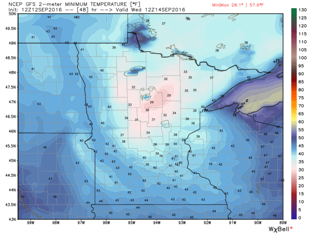
As that airmass settles in, low temperatures will drop into the 30s and 40s across the Northern Plains and Rockies tonight. Frost advisories and freeze warnings have been posted for western portions of North Dakota for Tuesday morning. By Wednesday morning, the coldest air will move over Minnesota, where low temperatures could drop into the upper 20s and 30s. Additional frost and freeze advisories will likely be issued for this region.

gfs_t2min_minnesota_9
A taste of things to come soon. GFS model forecast for low temperatures across Minnesota Wednesday morning. Image provided by WeatherBell.

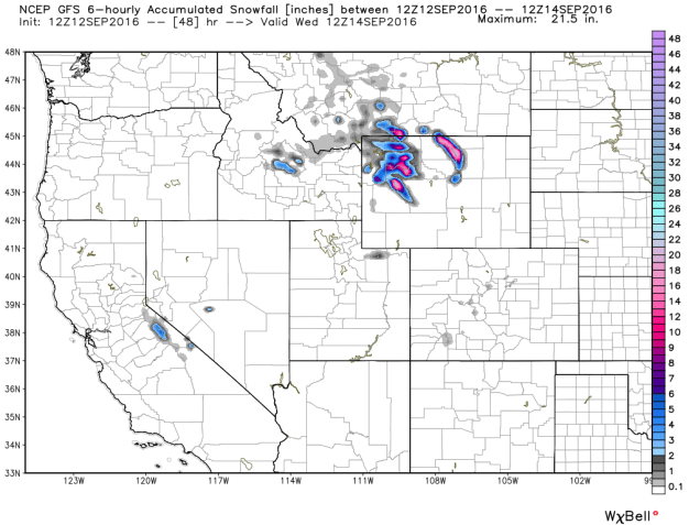
Cold temperatures aren’t the only noteworthy item with this cold front. As the cold air surges into the Rockies, precipitation will accompany it. That precipitation will likely fall as snow in many areas, mainly at elevations above 5000 feet. Across some of the higher peaks, more than a foot of snow could accumulate over the next day or two. Winter Weather Advisories have been issued for portions of northern Wyoming as a result.

gfs_6hr_snow_acc_cw_9
GFS model forecast for snowfall through Wednesday morning. Image provided by WeatherBell.

Some snow is also possible across the higher elevations of the Sierra Nevada as the cooler air spreads into the West. While accumulations will be minor, this will likely be the first snowfall of the year for this region. Across the rest of the Golden State, temperatures will likely be 6 to 12 degrees below normal on Tuesday, with highs only in the 70s to lower 80s, a welcome change from the 90s and 100s they’ve had for most of the summer.

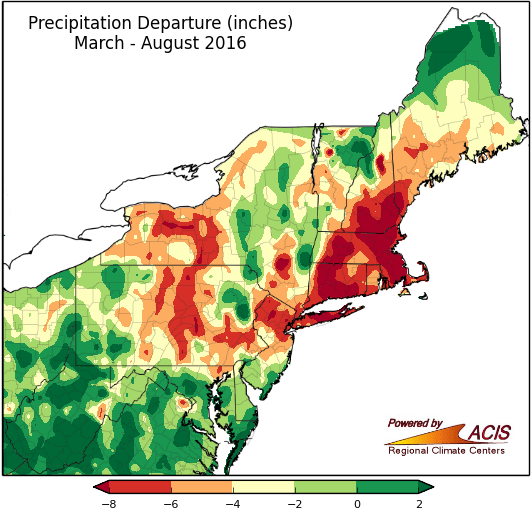
While this front will bring cooler air into our area later this week, one thing it won’t do unfortunately, is bring beneficial rainfall to the region. It will produce showers and some thunderstorms, and while a few of the storms may contain heavy downpours, they’ll be very localized. Across much of the region, rainfall totals will be generally under half an inch. This will do little to put a dent in the severe drought that much of the region is currently experiencing. Rainfall deficits of 5 to 10 inches below normal since the beginning of March are common across the region.We really need some rain, and there doesn’t look to be a lot of it on the horizon.

m6pdpt_northeast_aug16
Rainfall deficits across the Northeast from March 1 through August 31. Image provided by the Northeast Regional Climate Center.

While this early taste of fall moving into much of the Northern US this week is not uncommon for mid-September, it might not be repeated much this fall. Long-range forecasts are showing the likelihood of a warmer than normal fall across much of the United States.

Weekly Outlook: September 12-18, 2016

It’s getting tough to find ways to say the same thing every week, but we’ll try. Most of the upcoming week will be dry, but unlike much of the past few months, temperatures will start to turn cooler. Of course, this is expected, since we’re into the middle of September already and it couldn’t stay hot forever.

The week will start off on a cool note, as high pressure builds in, but as it moves offshore, we’ll warm up for Tuesday and Wednesday. Humidity will make a comeback on Wednesday as well, but a cold front will start to approach from the west. That front may give us a few showers late Wednesday and Wednesday night, but a drought-busting rainfall is not expected. After that, high pressure comes back for the end of the week, and this time, it’ll turn even cooler. How cool? Throw a blanket on the bed, because a lot of us could wake up to lows in the 40s Friday morning.Temperatures warm up again next weekend, but another cold front will start to approach, and it could bring in some showers late Sunday.

gfs_t2min_boston_19
GFS model forecast for low temperatures Friday morning. Image provided by WeatherBell.

Just remember, a couple of days of cool weather is expected at this time of year. Things could be a lot worse. Out in the Northern Rockies, over the next few days, some places, mainly above 5000 feet elevation could pick up a foot or more of snow. Yeah, you read that right.

gfs_6hr_snow_acc_nw_9
GFS model forecast for snowfall through Tuesday evening across the Northern Rockies. Image provided by WeatherBell.


No snow here for quite some time, but here are the details for the next week:

Monday: Harris K. Telemacher said it best in “L.A. Story” – Sun! Sun! Sun! High 71-78.

Monday night: Clear skies. Low 52-59.

Tuesday: Sunshine and a few clouds. High 77-84.

Tuesday night: Clear to partly cloudy. Low 59-66.

Wednesday: Morning sunshine, then increasing clouds. A few showers are possible late in the day. Humid. High 81-88.

Thursday: Becoming mostly sunny. High 67-74.

Friday: Plenty of sunshine. High 70-77.

Saturday: A mix of sun and clouds.High 73-80.

Sunday: Becoming cloudy and breezy, showers are possible in the afternoon. High 74-81.


Weekly Outlook, September 5-11, 2016

While the forecast for the upcoming week seems like it should be complicated, in reality, it isn’t, even with a former hurricane sitting just a couple of hundred miles to the south.

Hermine mills around south of the region for a few days. This gives us gusty winds, and periodic episodes of showers and steady rain into Wednesday, especially along the south coast. By Thursday, Hermine finally starts to pull away, the sun comes out, and it gets hot and humid again (summer’s not quite over yet folks). A cold front moves through Thursday night, with a few showers and thunderstorms possible.It’ll still be warm for Friday and Saturday, but without the humidity as high pressure builds in. Another front starts to approach on Sunday. Heat and humidity return ahead of it, but showers and thunderstorms accompany it as it moves through late in the day.

gfs_mslp_uv10g_boston_4
The strongest winds from Hermine are expected later today when gusts of 30-50 mph are possible across much of the region. Image provided by WeatherBell.

Monday: Cloudy and breezy with occasional showers and periods of steady rain at times. High 68-75.

Monday night: Cloudy and breezy with more showers possible, especially closer to the south coast. Low 59-66.

Tuesday:Mostly cloudy and breezy, more episodes of showers are possible. High 70-77.

Tuesday night:Mostly cloudy, still breezy along the south coast. Some additional showers may move through. Low 62-69.

Wednesday:Mostly cloudy with some more showers possible, still breezy across the Cape. High 77-84.

Thursday: Becoming partly sunny and humid. Some showers and thunderstorms are possible in the evening and at night. High 84-91.

Friday: A mix of sunshine and clouds, drier. High 83-90.

Saturday:Mostly sunny. High 83-90.

Sunday: Increasing clouds with afternoon showers and thunderstorms possible. High 82-89.

What’s Going On With Hermine?

Labor Day Weekend is here, and the big question on everyone’s mind is “What is Hermine going to do?” We’ll try to answer that as best as we can right now.

vis_lalo-animated
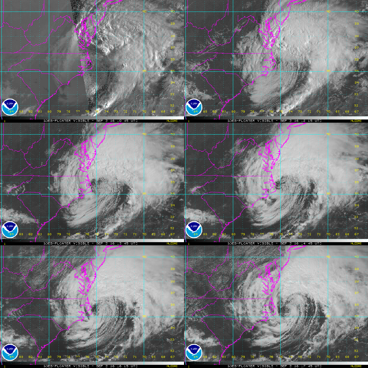
Satellite loop of Hermine. Loop provided by NOAA.

First, we’ll give you the facts. As of 2pm EDT, Hermine was centered about 90 miles east of Duck, North Carolina, moving toward the east at 10 mph. Maximum sustained winds are near 70 mph. Hermine is now a “post-tropical” storm. What does that mean? Well, to start with, it means that’s it’s no longer tropical. It’s more like a typical Nor’easter that we see throughout the fall, winter, and spring. As you can see in the satellite loop above, most of the thunderstorm activity is now well north of the center of circulation. Tropical systems contain thunderstorm activity concentrated near the center of the storm.

093728R_sm
Map showing current tropical storm watches and warnings as well as the extent of strong winds with Hermine. Image provided by the National Hurricane Center.

Despite the fact that Hermine is no longer tropical, Tropical Storm Warnings remain in effect for the East Coast from Ocracoke Inlet, North Carolina to Watch Hill, Rhode Island. A Tropical Storm Watch is in effect from Watch Hill up to Sagamore Beach, Massachusetts, which includes all of Cape Cod, the Islands, and the coast of Rhode Island.

So, if it’s no longer tropical, why are there tropical storm watches and warnings in effect? There are two reasons for this. The first, and simplest one, is the fact that there is a chance Hermine could re-acquire tropical characteristics as it sits over the warm waters of the Gulf Stream over the next few days. The other reason is related to Sandy. As you may recall, when Sandy slammed into New Jersey in 2012, there were no hurricane warnings in effect, despite the fact that Sandy was still a Category 1 hurricane while offshore. The reason there were not warnings was because Sandy was expected to become “post-tropical” before landfall, and the rules that the Hurricane Center had to abide by at the time did not allow them to issue watches/warnings if the system was not expected to impact the coast as a tropical system. (Yeah, we think it was stupid too.) So, they changed those rules, and this is the first test of them.

al092016
Computer model forecasts for the track of Hermine. Image provided by the University of Wisconsin.

So, what does the future actually hold for Hermine? Hermine will stall out east of the Delmarva Peninsula tonight and Sunday as it gets stuck under an upper-level low pressure system. It will then drift around south of Long Island for a few days. While it’s sitting over the warm water there, it could become a tropical system again (possibly even a hurricane), but that won’t last too long. Why? As it sits over the same area, it will churn up the waters, which will bring cooler water to the surface through a mechanism called “upwelling.” As this cooler water comes up, the system will lose the warm water it needs to sustain a tropical system, and then lose any tropical characteristics it may have gotten back. In other words, it’ll be “post-tropical” again.

ww3_height_dir_bermuda_17
Wave Watch model forecast for expected wave heights along the East Coast Monday morning. Image provided by WeatherBell.

In terms of sensible weather, Hermine is going to lay the smack down on the Mid-Atlantic states. Rough surf will pound the coast, especially in New Jersey, for several days, along with strong winds right along the coast. Wind gusts of 40-60 mph are expected along the Mid-Atlantic coast, along with some periods of rain, though the heaviest rain should stay off shore for the most part.

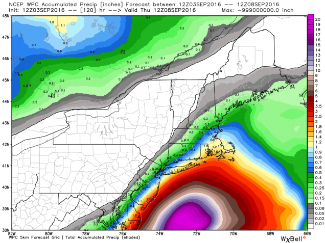
wpc_total_precip_neng_20
Expected rainfall through Thursday morning. Image provided by WeatherBell.

What about here in New England? We’re going to escape the brunt of it. There will be some very rough seas, starting on Sunday and likely continuing through at least Wednesday. It’s probably a good idea to stay out of the water if you’re heading to the beach, as the risk for rip currents will be high. Likewise, you probably don’t want to be heading out on a boat, with seas of 10-20 feet expected. If you’re taking one of the ferries to the Vineyard, Nantucket, or Block Island, there will likely be times where they have to cancel them due to rough seas. In terms of winds, the strong winds are likely right along the South Coast and across the Cape and Islands. Wind gusts of 30-40 mph or more are likely at times right through at least Tuesday. The bulk of the rain will stay to our south, but periodic showers and occasional batches of steady rain will come through at times over the next several days. The graphic above might be overdone in terms of how much rainfall we’ll get, but there will likely be some rain at times, especially the farther south you head.

Hermine likely won’t start to move out of the picture until the latter half of the week. Until then, we’ll just head to deal with clouds, periodic showers, occasionally strong winds, and rough surf for several days. In other words, it’ll feel like a typical April week, expect temperatures will be in the upper 60s and 70s instead of 40s and 50s.


Hurricane Hermine Heading Here?

(Note: This post was edited to reflect the fact that Hermine was upgraded to a hurricane at 3pm EDT)

We’re just about to start the Labor Day Weekend, traditionally summer’s last gasp around here, and the big question on everyone’s mind is “Will Hurricane Hermine ruin my plans?” The short answer is “maybe.”

rb_lalo-animated
Satellite loop of Tropical Storm Hermine. Loop provided by NOAA.

First, let’s start off with the basic facts. As of 3pm EDT, Hurricane Hermine was centered about 115 miles south-southwest of Apalachicola, Florida, and was moving towards the north-northeast at 14 mph. The storm has maximum sustained winds of 75 mph, and some more strengthening is possible before landfall just east of Apalachicola tonight.A Hurricane Warning is in effect for the coast of Florida from Mexico Beach to the mouth of the Suwanee River. Hurricane watches and Tropical Storm Warnings are also in effect for much of the remainder of the Florida Gulf Coast, as well as much of the Atlantic Coast from northeastern Florida up to North Carolina.

153730R_sm
Map showing the extent of tropical storm force winds with Hermine and all current watches and warnings. Image provided by the National Hurricane Center.

OK, now that we’ve got the facts spelled out, here’s what we’re fairly sure about: Hermine will likely make landfall a little east of Apalachicola, Florida tonight. This will be the 1st hurricane to make landfall in Florida since Hurricane Wilma on October 24, 2005, ending Florida’s record 11-year “hurricane drought.” Once it makes landfall it will move up across Georgia and into the Carolinas, slowly weakening while dropping heavy rainfall on the region. Flooding is almost a certainty in some areas. The center of Hermine should move back out into the Atlantic off the North Carolina coastline, possibly as far north as Norfolk, Virginia by late Saturday. Once off the coast, the storm will likely drift northward and then stall east of the Delmarva Peninsula on Sunday. This is where things get tricky.

wpc_total_precip_se_16
Rainfall forecast through Monday morning. Image provided by WeatherBell.

We’ve gone over what is going on currently, and what we’re fairly sure will happen over the next 2-3 days. Now, we’ll delve into the parts that we don’t have a handle on yet. Once the storm stalls east of the Delmarva Peninsula, we have a lot of questions that just can’t be answered right now. Where does it actually stall? How long does it stall? Which way does it drift once it does stall? How strong will it be? How large will the wind field be? How large will the precipitation field be? These are all important details that have a HUGE effect on the forecast. Unfortunately, we won’t have a better idea of these details for another 24 or even 48 hours.

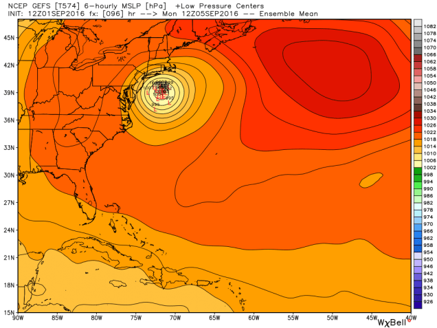
gefs_slp_lows_swatl_17
GFS Ensemble Forecast for the position of low pressure Monday morning. Note that while the different members all have the low positioned south of Long Island, there is some variation in all directions as to exactly where the storm will be centered. Image provided by WeatherBell.

While we’re not expecting Hermine to be a hurricane once its off the Delmarva Peninsula, it could still be a tropical storm once it is east of the Delmarva Peninsula. More likely, it will become extratropical. What does that mean? To put it in simple terms, it will be more like a typical Nor’easter around here.

If you’ve got Labor Day Weekend plans, don’t scrap them just yet, but have a backup plan ready. The farther north your plans are, the less likely that you’ll be impacted. However, the closer you are to the South Coast or the Cape, the greater the chance that you may be dealing with gusty winds and/or rainfall. (Rough surf is a virtual lock at this point, so staying out of the water is probably a good idea).

We should be able to provide an update this weekend, once things become a little more certain.


Tropical Trouble? Several Storms Could Threaten Land Areas

The peak of hurricane season is normally a 6-week period from late August until late September. This year is no exception. We currently have five active tropical systems that we’re tracking, and more may be on the way. Of the five that are currently out there, all of them are a threat to some land areas, four of them to parts of the United States.

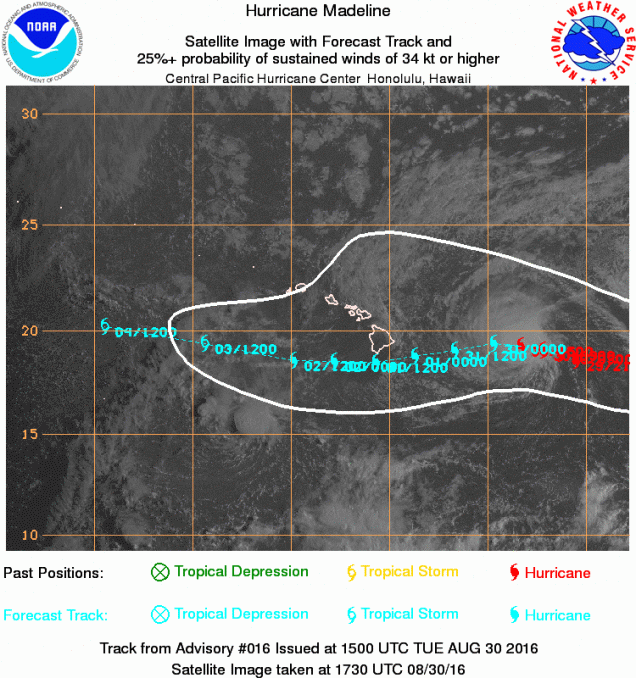
probEP142016_160830_1730_sata
Satellite photo and forecast track for Hurricane Madeline. Image provided by the Central Pacific Hurricane Center.

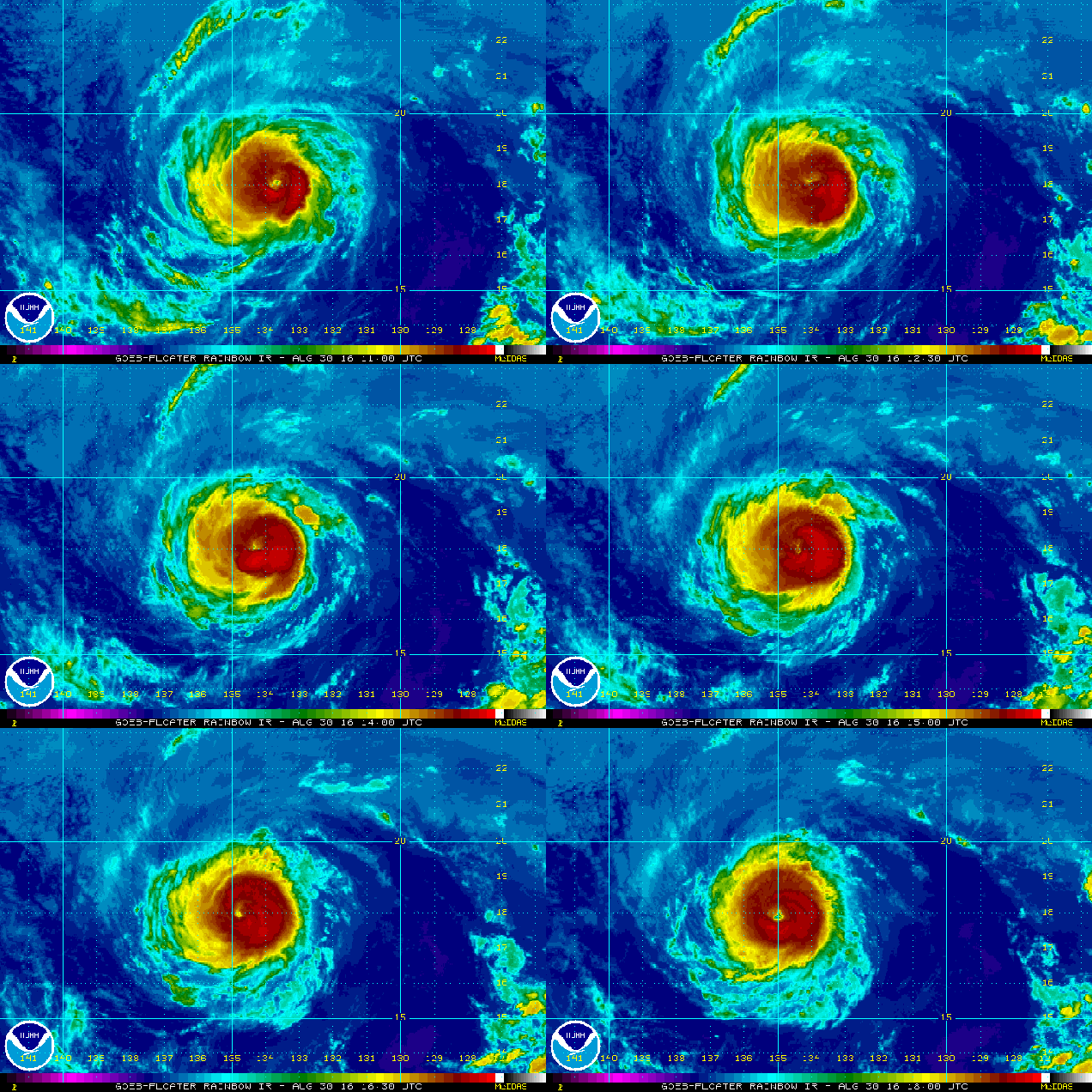
We’ll start in the Central Pacific where Hurricane Madeline is bearing down on parts of the Hawaiian Islands. As of 8am HST Tuesday, Hurricane Madeline was centered about 415 miles east of Hilo, Hawaii, moving towards the west at 10 mph. Maximum sustained winds are near 120 mph, making Madeline a Category 3 Hurricane on the Saffir-Simpson Scale.  A Hurricane Watch and Tropical Storm Warning have been issued for the Big Island of Hawaii, and a Tropical Storm Watch has been issued for Maui County, including the islands of Maui, Molokai, and Lanai. It is extremely rarely for a storm impact Hawaii as a hurricane when moving in from the east. The current forecast calls for Madeline to pass just south of the Big Island with some weakening expected. Most hurricanes that impact Hawaii are traveling from south to north. Madeline should pass close enough to Hawaii to bring strong winds and heavy rain to some of the southernmost islands. Rainfall totals of 5-10 inches and locally heavier are possible, especially in the windward sides of the islands. Rough surf will pound most of the islands for the next several days.

rb_lalo-animated
Satellite loop of Hurricane Lester. Loop provided by NOAA.

Next up is Hurricane Lester, which was centered about 1350 miles east of Hilo, Hawaii at midday, moving toward the west at 14 mph. Lester has top winds near 120 mph, is expected to steadily weaken over the next few days while continuing in a general westward direction. While Lester is not a threat to land for the next few days, that could change by the end of the week. The current track calls for Lester to gradually turn more towards the west-northwest and northwest by Friday and Saturday, passing a little north of the Hawaiian Islands. While this track would likely spare the islands from most of the wind and rain, if Lester makes that turn a bit later, it would pass a lot closer to the islands. Residents of Hawaii should make sure to keep tabs on Lester’s progress once Madeline moves away from the region.

07L_tracks_latest
Model forecasts for the track of Hurricane Gaston. Image provided by Tropical Tidbits.

Closer to the mainland we find Tropical Depression Eight. The storm was centered about 70 miles south of Cape Hatteras, North Carolina early Tuesday afternoon and was nearly stationary. Maximum sustained winds are near 35 mph. A slow drift toward the north is expected tonight and Wednesday, with some strengthening possible as the storm moves over the warm waters of the Gulf Stream. A Tropical Storm Warning is in effect for the coast of North Carolina from Cape Lookout to Oregon Inlet. Wins gusts to 30-40 mph and locally heavy rainfall are expected over the Outer Banks of North Carolina tonight and Wednesday. After that, the system should start to head out into the Atlantic and dissipate by later in the week.

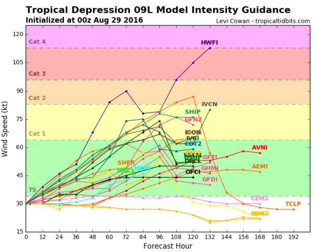
Finally, we get to Tropical Depression Nine, which was centered about 340 miles west of Key West, Florida at midday Tuesday. The storm has maximum sustained winds of 35 mph, and was moving towards the west-northwest at 7 mph. This is the same storm we’ve been watching for a week-and-a-half that was supposed to be the next “Storm of the Century”. Well, it might finally be starting to get its act together. The forecast for this system calls for a turn more towards the north and eventually northeast as an upper-level trough of low pressure starts to steer the system. Strengthening is expected, and the depression could become a tropical storm tonight or early Wednesday. Tropical Storm Watches will likely be issued for parts of the Gulf Coast later today or tonight. Some of the models show the possibility of the storm becoming a hurricane before making landfall along the Florida Gulf Coast later this week. Once it makes landfall, it should quickly cross the Southeast, then emerge into the Atlantic, where some re-strengthening is possible. The system will likely bring heavy rain and gusty winds to parts of the Carolinas, but beyond that its future is uncertain. Some models indicate that it will continue northeastward, out into the Atlantic, while others try to slow it down and head northward up the East Coast in a much-weakened state. Since this could have an adverse impact on the Labor Day Weekend up here, we need to pay close attention to it.

09L_tracks_latest
Model forecasts for the track of Tropical Depression Nine. Image provided by Tropical Tidbits.
09L_intensity_latest
Model forecasts for the intensity of Tropical Depression Nine. Image provided by Tropical Tidbits.

Finally, a new tropical wave has emerged from the coast of Africa. This wave will cross the Cape Verde Islands tonight, then head westward across the Atlantic. Conditions are favorable for further development, and many of the forecast models show the possibility of this system strengthening over the next several days. It is still at least 5 days away from impacting the eastern Caribbean, so there is plenty of time to monitor its progress before it threatens any land areas. If it does do what the models are showing, expect the hype machine to get cranked up to maximum again, as the next “Storm of the Century of the Week” could be a threat to the East Coast.

Weekly Outlook August 29-September 5, 2016

In a lot of ways, this week will be very similar to last week. That shouldn’t be a big surprise, we’ve been stuck in the same weather pattern for nearly the entire summer.

Buying-the-windshield-wipers-that-work-perfectly-for-my-car
These are called windshield wipers. You use them to clean the rain off of your windshield. Most of you probably haven’t used them much in the past few months.

Just like last week, we’ll start the week off with a cold front crossing the region early Monday. It may produce a few showers early this morning, but that’s about it. High pressure briefly builds in for Tuesday with drier conditions, then another cold front moves through on Wednesday. It may produce a few showers or thunderstorms late Wednesday. After that, high pressure builds in for the rest of the week and into the Labor Day Weekend with cooler and drier conditions. Dewpoints will likely be in the 40s again from Thursday into Saturday.

rb_lalo-animated
Satellite loop of Major Hurricane Gaston. To quote a friend “Now that’s an atmospheric heat engine.” Loop provided by NOAA.

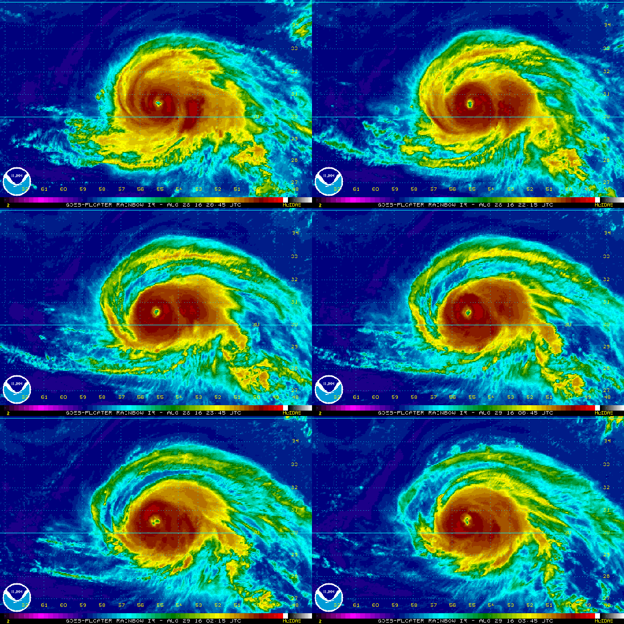
That large high pressure area building in will also be a “deflector shield” of sorts. There are currently three tropical systems in the Atlantic, and two of them, are not far from the US mainland. First we have Major Hurricane Gaston. Gaston has maximum sustained winds near 120 mph, making it a Category 3 Hurricane on the Saffir-Simpson Scale. Gaston is centered about 575 miles east of Bermuda tonight. Unless you’re in the middle of a Trans-Atlantic cruise, then you don’t have to worry about Gaston, as it will be heading out over the open Atlantic, no threat to any land areas. Gaston will start to send some rough seas our way though, so if you are planning on heading to the beach this week, be alert, as there will be a higher than now risk for riptides.

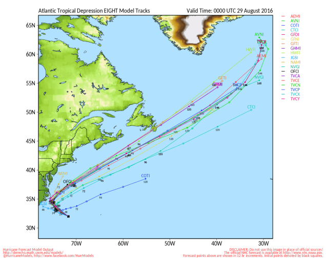
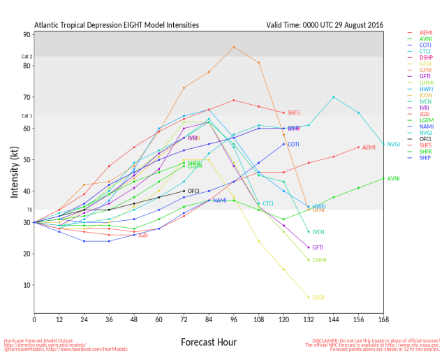
Closer to home, Tropical Depression Eight developed on Sunday. TD 8 has top winds near 35 mph, and is centered about 285 miles southeast of North Carolina. The forecast calls for TD 8 to strengthen into a tropical storm late Monday. Since it is expected to turn towards the northwest, a tropical storm watch has been issued for the Outer Banks of North Carolina from Cape Lookout to Oregon Inlet. After brushing the Outer Banks late Tuesday, it will turn more towards the north and northeast, merging with the cold front that will cross our region on Wednesday.

al082016
Model forecasts for the track of Tropical Depression Eight. Image provided by the University of Wisconsin.
al082016_inten
Model forecasts for the intensity of Tropical Depression Eight. Image provided by the University of Wisconsin.

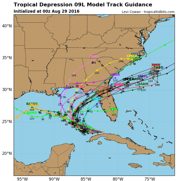
We also have Tropical Depression Nine, centered about 100 miles southwest of Key West, Florida and just off the north coast of Cuba tonight. This is the system that has been relentlessly hyped by many in the media and on the Internet (but not this site) for the past week plus as the next “Storm of the Century”. It finally developed a circulation center Sunday afternoon, and was deemed a tropical depression. If you believed many of the computer models and “Facebook Forecasters” earlier in the week, it was supposed to hit south Florida as a hurricane yesterday. Right now, it looks like the storm should turn more to the north while strengthening into a tropical storm over the next day or two. A track towards the Big Bend of Florida seems most likely at this point, but as this storm has shown already, it will do (or not do) what it wants to. Assuming it does track towards Florida, it should cross the Southeast, then emerge off the coast of Georgia or northeastern Florida. Once there, it will move over the warm waters of the Gulf Stream and could strengthen once again. However, with a big high pressure area to the north (we told you that we’d tie that in eventually), a track up the coast is unlikely. Instead, the system will likely head out into the open Atlantic.

09L_tracks_latest (1)
Model forecasts for the track of Tropical Depression Nine. Image provided by Tropical Tidbits.
09L_intensity_latest (1)
Model forecasts for the intensity of Tropical Depression Nine. Image provided by Tropical Tidbits.

So, here’s what we can expect around here right through and including Labor Day:

Monday: Chance for a few showers early, then becoming partly to mostly sunny. High 84-91.

Monday night: Clear skies. Low 56-63.

Tuesday: Partly to mostly sunny. High 78-85.

Tuesday night: Clear to partly cloudy. Low 60-67.

Wednesday: A mix of sun and clouds, chance for showers and thunderstorms during the late afternoon and evening hours.High 83-90.

Thursday: Partly sunny. High 75-82.

Friday: Intervals of sunshine and clouds.High 71-78.

Saturday: Sunshine and a few pop-up clouds.High 72-79.

Sunday: Mostly sunny. High 75-82.

Labor Day: Plenty of sunshine.High 77-84.


A Little Sizzle, a Lot of Fizzle (and Probably Some Drizzle) in the Tropics

As we get into the end of August, we are moving into the peak of hurricane season. As expected, the tropics have awakened, with plenty of activity to watch, but thus far, much of it remains disorganized.

two_atl_2d0
In addition to Tropical Storm Gaston, there are 3 disturbances being watched in the Atlantic. Image provided by the National Hurricane Center.

Starting in the Atlantic, we have Tropical Storm Gaston. Gaston was centered about 900 miles east-southeast of Bermuda Friday evening, moving towards the northwest at 15 mph. While Gaston was briefly upgraded to a hurricane earlier in the week, it currently has maximum sustained winds of 65 mph. Conditions are favorable for Gaston to strengthen this weekend and become a hurricane once again. The storm should turn more toward the north and eventually northeast, remaining over open waters into the start of the upcoming week.

gulf_cdas1
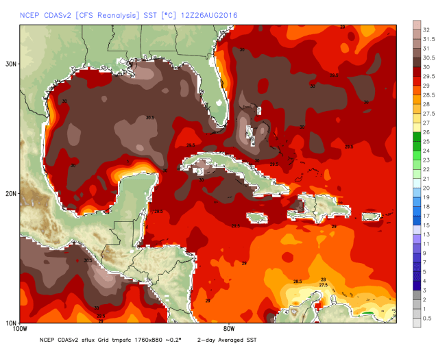
Current water temperatures across the Gulf of Mexico, Caribbean Sea, and Southwest Atlantic Ocean. A storm moving into this bath water could strengthen quickly. Image provided by WeatherBell.

A disorganized area of showers and thunderstorms is moving across the Central Bahamas this evening. This is the same storm that everyone on the Internet has been hyping up as next “Storm of the Century” for the past week. As you can see, it still hasn’t done anything, but that hasn’t stopped the hype at all. Conditions will be unfavorable into the weekend for any development of this system. Several models are still showing the potential for the system to develop once it gets into the Gulf of Mexico. Water temperatures are very warm across the Gulf, which would help to fuel any developing system. Will it ever develop? We’ll find out one way or the other in the next few days. Anyone with interests in and around the Gulf Coast should still keep an eye on the progress of this system, just in case it finally gets its act together.

wpc_total_precip_tx_12
Expected rainfall through Monday evening. Image provided by WeatherBell.

Meanwhile, there is a weak trough of low pressure already located in the northern Gulf of Mexico this is being watched. Upper-level conditions are not favorable for development of this system, but it will bring heavy rainfall to portions of Louisiana and Texas this weekend. This is not good news for areas that were hit hard by flooding just a few weeks ago.

Another disturbance has developed just south of Bermuda this evening. This system is expected to remain weak for the next few days while moving very little. Eventually it should start drifting westward, and some slow development is possible. This system may bring some showers and thunderstorms to Bermuda this weekend and parts of eastern North Carolina during the early part of the upcoming week, but otherwise should not have much of an impact on any land areas.

aal91_2016082700_track_early
Model forecasts for the track of a disturbance south of Bermuda. Image provided by NCAR.
aal91_2016082700_intensity_early
Model forecasts for the intensity of a disturbance south of Bermuda. Image provided by NCAR.

While the Atlantic is filled with potential tropical systems, the Pacific has a couple of named systems, one of which could be a threat to land.

vis_lalo-animated (1)
Satellite loop of Hurricane Lester. Loop provided by NOAA.

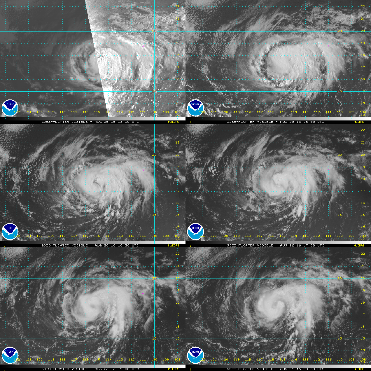
Hurricane Lester was centered about 550 miles southwest of Cabo San Lucas, Mexico Friday evening. Lester has maximum sustained winds near 75 mph, and additional strengthening is expected. Lester is currently moving toward the west at 9 mph, and a general westerly track is expected to continue through the weekend. Lester is not a threat to land for the next several days, however, some models are showing that it could have some impacts of Hawaii towards next weekend.

ep142016
Model forecasts for the track of Tropical Storm Madeline. Image provided by the University of Wisconsin.
ep142016_inten
Model forecasts for the intensity of Tropical Storm Madeline. Image provided by the University of Wisconsin.

Tropical Storm Madeline could be a more immediate threat to Hawaii. Tropical Depression 14-E developed earlier on Friday about 1250 miles east-southeast of Hilo, Hawaii, and was upgraded to Tropical Storm Madeline Friday evening. Madeline has maximum sustained winds near 40 mph, and additional strengthening is expected. Madeline could become a hurricane by the end of the weekend or beginning of next week. The storm is expected to track towards the northwest this weekend before turning more towards the west. On this track, Madeline could approach the Hawaiian Islands towards midweek. Residents of the region should keep an eye on Madeline’s progress during the next few days.

1610-00
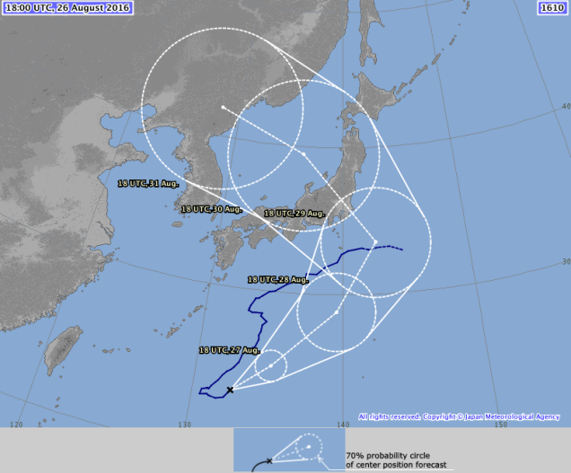
Forecast track for Typhoon 12W (Lionrock). Image provided by the Japan Meteorological Agency.

In the Western Pacific, Typhoon 12W Lionrock (Is that not the coolest name you’ve seen in a while for a tropical system?) has been slowly meandering around south of Japan for much of the past week, but that looks like it is about to change. As of Friday evening, the storm has maximum sustained winds near 110 mph, and some additional strengthening is possible this weekend. A track toward the northeast is expected this weekend, but a turn more toward the north and eventually northwest is likely by Sunday or Monday. On this track, the typhoon would make landfall in southeastern or eastern Japan on Monday.

Weekly Outlook August 22-28, 2016

As we start off the last full week of meteorological summer, some things will remain the same as they have for months – there will be very little rainfall, worsening an already severe drought across the region. Some things will change though – humidity levels will drop at least for a few days and so will temperatures.

20160816_northeast_trd
The only place in Southern New England not currently classified as being in drought is Nantucket Island. Image provided by the US Drought Monitor.

The week will start off with a little rain. However, by the time most of you read this, the rain will already have ended. A cold front will cross the region early Monday morning with showers and possibly thunderstorms. The rain should end towards daybreak, then skies will quickly clear out as the front pushes offshore. After that, high pressure builds in, with much drier air for Monday and Tuesday. How dry? How does dewponts in the 40s sound?  Temperatures will actually be near or a little below normal as well. By Wednesday, the high moves offshore, winds become southwesterly, and both the temperature and humidity start to rise again. On Friday, another cold front sweeps across the region, with a few showers and thunderstorms expected. Cooler and drier air returns next weekend.

Umbrella-PNG-Pic
Just in case you forgot, this is called an umbrella. You use it to keep yourself dry when it rains. Most of you probably haven’t seen one for months.

Monday: Showers ending around daybreak, then becoming partly to mostly sunny, breezy, and less humid. High 76-83.

Monday night: Clear skies. Low 53-60.

Tuesday: Wall-to-wall sunshine. High 75-82.

Tuesday night: Clear skies. Low 54-61.

Wednesday: Sunshine and a few clouds. High 83-90.

Thursday: Partly to mostly sunny. High 82-89.

Friday: A mix of sun and clouds with afternoon showers and thunderstorms possible. High 83-90.

Saturday: Mostly sunny. High 79-86.

Sunday: Partly to mostly sunny. High 77-84.

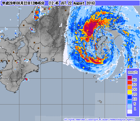
As this post is being written, Typhoon 10W (Mindulle) is making landfall very close to Tokyo. That’s probably not good. If you’re looking for an update on the massive hurricane that’s supposed to wipe out the East Coast just before Labor Day, then you’re out of luck. because it’s a fantasy that will not likely happen. Oh, we’ve got plenty of activity – Tropical Depression Fiona is dying southeast of Bermuda. There are two other areas we’re watching, one of which could become a tropical depression on Monday. The odds of either of those impacting the East Coast are still fairly small though. If there is a potential threat, we’ll let you know all about it.

201608221245-00
Radar image of Typhoon 10W (Mindulle) making landfall near Tokyo. Image provided by the Japan Meteorological Agency.