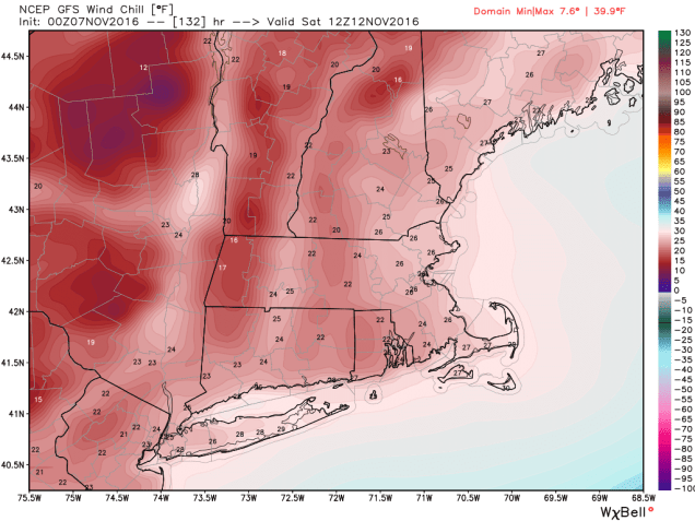
The votes are in – most of this week will feature some decent weather. However, it’s not all good news. Mother Nature has elected to remind us that it’s November, and it looks like we’re going to have our inaugural visit of arctic air next weekend.
We’ll start the week with high pressure giving us sunshine and cool temperatures on Monday. As the high slides offshore, we’ll warm up on Tuesday. A weak cold front moves through on Wednesday, but we’ll only see a few showers with the front. High pressure returns for Thursday and Friday before the next cold front comes through Friday night. Then, we get to the weekend. Hope you’ve got your heavier jackets out of the closet, because you’ll need them. Gusty northwest to northerly winds will not only bring in some of the coldest air so far this season, they’ll also re-introduce a phrase you haven’t heard in several months – “wind chill”. Oh, and there’s even the chance for a few rain or snow showers (yes, we said the s-word).
Monday: Plenty of sunshine. High 46-53.
Monday night: Clear skies. Low 28-35.
Tuesday: Mostly sunny and milder. High 57-64.
Tuesday night: Increasing clouds. Low 38-45.
Wednesday: Mostly cloudy with some afternoon showers possible. High 53-60.
Thursday: Partly to mostly sunny and breezy. High 46-53.
Friday: A sunny start, then clouds move in, becoming windy. High 50-57.
Saturday: Intervals of sun and clouds, windy, chance for a rain or snow shower. High 38-45.
Sunday: Partly to mostly sunny. High 43-50.
If you’re worried about an early season snowstorm, you can stop. There doesn’t appear to be anything of note to worry about over the next couple of weeks. It’s fairly rare to have a snowstorm this early in the season around here. Sure, there are a few examples (Snowtober 2011, Veterans Day 1987), but normally, you need to get into late November, or more likely December, before we get a true “snowstorm” around here. For now, we only have to worry about the crapstorm known as the Election for 2 more days.

