Snow in the Forecast? Not for Most of Us

By now, you’ve probably heard from your favorite TV meteorologist that there’s snow in the forecast for Thursday. While parts of the region will likely see some snow on Thursday, the vast majority of us will not.

High pressure will provide us with some chilly weather for the next few days. Temperatures will likely dip near or below freezing across much of the area tonight and again Wednesday night. So, we’ve got cold air in place, and a storm system heading our way on Thursday. That means it’s going to snow, right? As famed college football analyst Lee Corso would say “Not so fast my friend”. Allow us to explain.
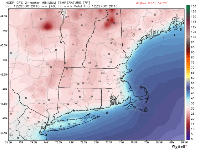
gfs_t2min_boston_9
Thursday morning will start off with temperatures below freezing across much of the region. Image provided by WeatherBell.

As that high pressure area moves off to the east, winds will shift into the east and southeast across the region. Water temperatures off the coast are still in the 50s to lower 60s, so a wind off the water will allow temperatures to moderate. Thursday will still be a chilly day, with temperatures mainly in the 40s, but the air will remain dry, thanks to the high pressure area. As the precipitation arrives from the west during the afternoon, it will fall into that dry air, evaporating before it hits the ground. This will also allow temperatures to drop through a process called evaporational cooling. Temperatures may drop into the upper 30s to lower 40s before the air moistens up enough for the precipitation to hit the ground.

qpf_acc-us_ne
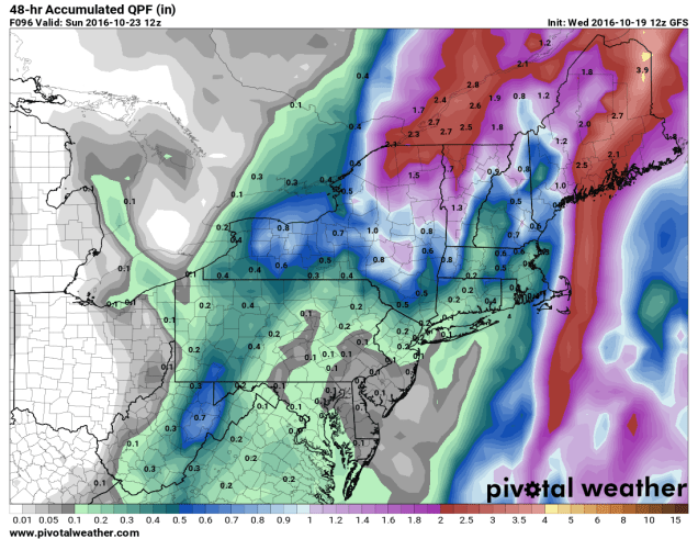
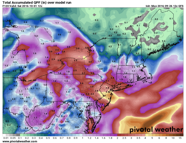
GFS model forecast for rainfall through Friday afternoon. Image provided by Pivotal Weather.

With temperatures likely near or just above 40, we’re looking at mainly rain across most of our region. Oh sure, there could be a renegade snowflake or ice pellet mixed in at the start across parts of southern NH or central MA, but for the most part, we’re looking at rain, and possibly a decent amount of it. Much of the region could receive between 0.75″ and 1.50″ of rain from this system, which will help put a dent into the ongoing drought.

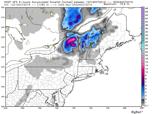
Farther to the north and west, especially across the higher elevations of the Berkshires, Monadnocks, and the mountains of Northern New England, temperatures will be cooler, and the precipitation will arrive faster, thus increasing the chances that it starts as snow. Even in these locations, warmer air will move in Thursday night, allowing the snow to change over to rain. Before that happens, we could see a little accumulation, especially at the higher elevations, where a few inches may accumulate. The best chance for accumulating snow actually looks to be across the Adirondacks of northeastern New York, where the warm air will have a tough time getting in.
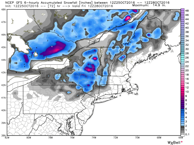
gfs_6hr_snow_acc_neng_13
Snowfall forecast from the GFS through Friday morning. Image provided by WeatherBell.

Once we get past this system, we could be looking at a wet weekend and start of next week. A couple more storms may move across the region, bringing us several bouts of much-needed rainfall. It does not look like there will be more snow with these systems, except possibly across the mountains of northern New England.

Weekly Outlook: October 24-30, 2016

In the past several days, we’ve had 80-degree temperatures setting record highs, torrential downpours leading to flooding, several inches of snow across the higher elevations, and wind gusts to 60 mph across the region. Believe it or not, there’s a technical term for all of this: “October” While we’re still in October, things will be a lot less volatile during the upcoming week.

sf1_today
Parts of Northern New England received several inches of snow Saturday night, especially at the higher elevations. Image provided by NOAA.

We’ll start the week off with a little bit of rain as a weak system moves across the region. The rain will be mainly confined to areas south of the Mass Pike, and should be all done before many of you get to work Monday morning. It will remain windy into Tuesday as the storm that brought us the heavy rain Friday continues to sit and spin across southeastern Canada. High pressure then builds in, giving us dry but rather cool conditions for mid-week.The next system gives us some rain Thursday into early Friday. While there could be some downpours, we’re not looking at anything like what we saw Friday night. High pressure then builds in for the weekend, but another storm looks to approach late Sunday night and into Halloween. Right now, it looks like the rain will be out of here in time for trick-or-treaters, but we’ve got plenty of time to keep an eye on that system.

ndfd_t2max_climo_massachusetts_3
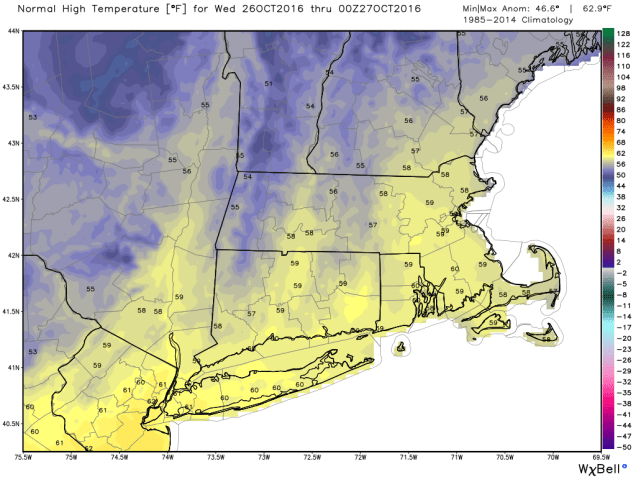
On average, high temperatures should be in the upper 50s to near around here in late October. Much of the upcoming week will see highs 10-15 degrees below normal. Image provided by WeatherBell.

Monday: Showers in the morning, then becoming partly sunny and windy in the afternoon. High 52-59.

Monday night: Clear to partly cloudy and breezy. Low 32-39.

Tuesday: Partly to mostly sunny, still breezy. High 43-50.

Tuesday night: Clear skies. Low 29-36.

Wednesday: Sunshine and a few clouds. High 41-48.

Thursday: Becoming mostly cloudy with showers developing late in the day, becoming a steady rain at night. High 46-53.

Friday: Rain ending in the morning, then becoming partly sunny and breezy. High 53-60.

Saturday: Mostly sunny. High 50-57.

Sunday: Becoming mostly cloudy with showers developing at night. High 48-55.

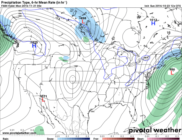
Finally, since we’re getting to the time of year where people start wondering when the snow will start to fall around here, we figured we’d try to answer that. Now, we understand that some of you ask this question because you love winter, and some ask because you dread it and want to know when your luck will run out. There’s a model called the CFS, that actually goes out several months. We put zero stock in this model, and are only presenting it for entertainment purposes only. In other words, the odds that this model is right are roughly the same odds that the Cubs win the World Series the Jets win the Super Bowl this year.

prateptype_cat-conus
CFS model forecast for Sunday evening November 20, showing the first snowfall for Southern New England. We’re just showing you what the model has, not that we believe it. Image provided by Pivotal Weather.

A Little Bit of Everything – October in the Northeast

October can be a time of change in the Northeast. While the first thing that comes to mind is the changing colors of the foliage across the region, the weather also changes, sometimes quite frequently. That’s what we’re going to be dealing with for the next few days.

rtma_t2m_neng
Current temperatures across the Northeast as of 1pm on October 19. Image provided by WeatherBell.


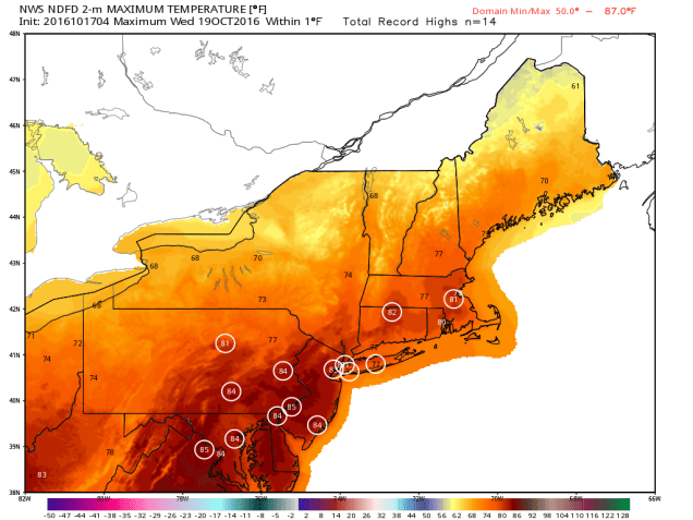
It’s an unseasonably warm afternoon across much of the Northeast, with temperatures generally in the 60s and 70s, with 80s from southern Connecticut into the Mid-Atlantic states. Dozens of record highs have been set over the past few days, and more are falling today. However, some changes are coming, and the warm weather will be a distant memory within the next 24-48 hours.

A cold front is moving across the region this afternoon, though you really couldn’t tell, as there’s only scattered cloud cover and little precipitation with the front. That front will stall out to the south of New England tonight. On Thursday, a wave of low pressure will start to approach from the west. This will spread rain and showers into the region. Some of the rain will be heavy, especially from New York into Pennsylvania late Thursday into Friday. With rainfall totals of 1-3 inches and locally up to 5 inches expected, some flooding is likely. Across New England, where a serious drought is ongoing, rainfall will be much lighter, with most locations likely receiving under half an inch of rain.

qpf_acc-us_ne
Expected rainfall through Friday evening across the Northeast. Image provided by Pivotal Weather.


As that wave of low pressure moves into Upstate New York on Friday, it will lift that cold front back across New England as a warm front. While Friday won’t be as warm as today, temperatures will still get into the 60s and lower 70s across much of New England. With dewpoints also in the 60s, it will be a rather muggy day for mid-October.

99l_tracks_latest
Computer model forecasts for the track of a tropical disturbance in the Bahamas. Image provided by Tropical Tidbits.


Meanwhile, there is a tropical disturbance brewing in the Bahamas right now. While conditions are favorable for development, we’re not looking at another monster like Matthew, it could become a tropical depression or subtropical storm over the next few days. The system will likely head northward, moving towards the Gulf of Maine as we head into the weekend. This will bring another round of heavy rainfall into Maine and Atlantic Canada, again missing most of Southern New England, where the rain is most needed.

qpf_048h-us_ne
Expected rainfall between Friday morning and Sunday morning across the Northeast. Image provided by Pivotal Weather.


Once the system moves into southeastern Canada, it is expected to stall out under an upper-level low pressure area and become a strong extratropical system. It will drag a cold front across the Northeast, bringing much colder air into the region. With strong low pressure nearby and much colder air filtering in, rain will change over to snow across portions of Upstate New York and Northern New England. While the snow will be confined mainly to the higher elevations, this is the first accumulating snow of the season across the area. Several inches may accumulate across parts of the Adirondacks and the Green Mountains.

gfs_6hr_snow_acc_neng_19
Expected snowfall through Sunday evening across the Northeast. Image provided by WeatherBell.


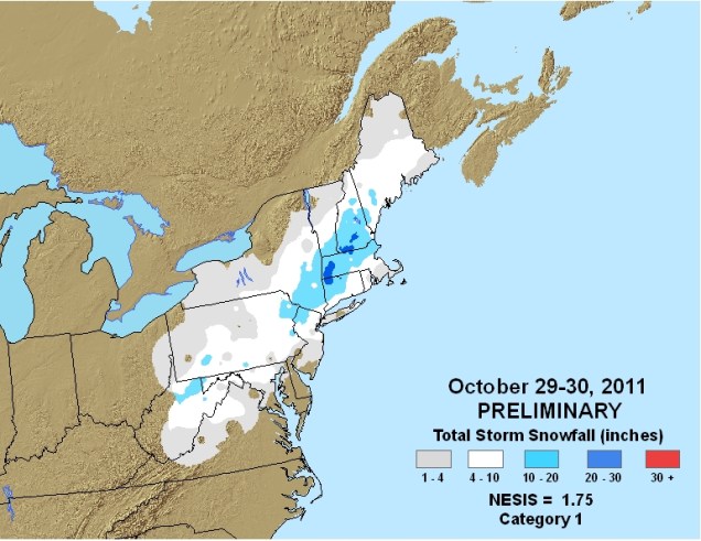
While there could be a few wet flakes mixed in with some of the rain across lower elevations of Central New England, accumulating snow is not expected.Sunday will be a chilly day, with highs only in the 40s and 50s across much of the Northeast. These readings are 10-20 degrees below normal. Of course, any mention of snow in October across the Northeast will make residents think back just a few years to the pre-Halloween snowstorm that dropped 1-2 feet of snow across parts of the region, setting numerous records. While this system won’t come anywhere close to that, it should make for some spectacular photos of snow-capped mountains and valleys filled with colorful foliage early next week.

20111029-20111030-1-75
Snowfall from the Halloween snowstorm of 2011. Image provided by NOAA.


Weekly Outlook October 17-23, 2016

As you can probably guess from the video above, we’ve got some changes coming this week. A weak cold front will drop down into the region today, with just a chance for a few showers as it moves through. That front will lift back northward as a warm front as we head into Tuesday, bringing us some Indian Summer weather for midweek. The front may take its time heading northward, so the warmer air may not reach the Seacoast of New Hampshire until late in the day. Once that warmer air settles in, we could even set some record highs, especially on Wednesday. A cold front moves through late Wednesday, bringing some cooler conditions in for Thursday, but little rainfall.

ndfd_record_hi_neng_3
Some record high temperatures are possible on Wednesday across the area. Image provided by WeatherBell.

But wait, things change again after that! That cold front stalls out to our south, and a wave of low pressure rides along it. At the same time, an area of low pressure may try to move up the East Coast. As a result, Friday could be a rather wet day. How much rain we get depends on where the front is located and how close the coastal low comes to New England. It appears as though the front may lift back northward again as warm front, which would mean another mild day, but also focus most of the rain across northern New England.

That’s not all though, as there are even more changes next weekend! The coastal low pulls away from the region and the cold front moves well offshore, with high pressure starting to settle in. That will bring much colder air into the region by Sunday, despite some sunshine. How cold? There might even be some snow showers across the higher elevations of northern New England. That chilly air likely hangs around into the first part of the next week.
Monday: A mix of sun and clouds, slight chance for a shower. High 70-77.

Monday Night: Partly to mostly cloudy. Low 52-59.

Tuesday: Partly to mostly sunny and becoming breezy. High 75-82, though it could stay cooler along the NH Seacoast and possibly the North Shore.

Tuesday Night: Clear skies, breezy. Low 59-66.

Wednesday: Sunshine and a few clouds. High 75-82.

Thursday: Plenty of clouds, slight chance for a few showers late in the day. High 63-70.

Friday: Mostly cloudy with showers likely. High 63-70.

Saturday: More clouds than sunshine, more showers possible, mainly in the morning, becoming breezy. High 57-64.

Sunday: Sunshine and some afternoon clouds, breezy. High 54-61.

Weekly Outlook October 10-16, 2016

We finally got the beneficial rain we that we really needed on Sunday. Of course, we need a lot more of it. This week, we’re not going to get it. So while you won’t need an umbrella, you will need to dig out your fall coats and/or sweatshirts, because it’s going to turn cooler.

rb-animated
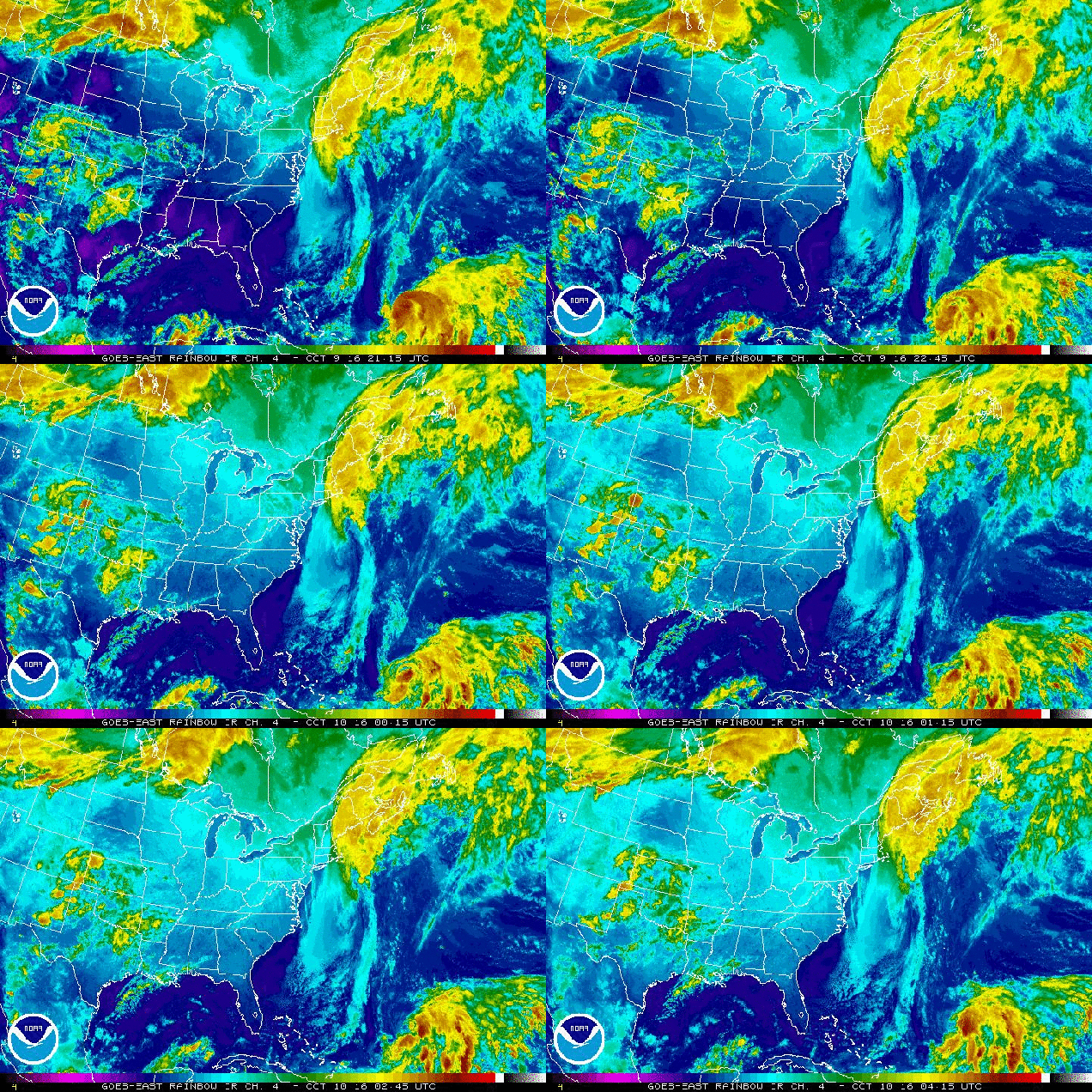
Satellite loop showing the moisture from what’s left of Matthew streaming into Atlantic Canada early this morning while Nicole starts to strengthen south of Bermuda. Loop provided by NOAA.

A cold front will continue to pull away from the region today and high pressure will build in. This will result in dry and cool conditions into at least Wednesday. By Thursday, we’ll be back in a somewhat similar pattern to what we had on Sunday. A cold front will be approaching from the west, and Hurricane Nicole will be well offshore after making a close pass to Bermuda. Unlike Sunday, Nicole should be too far offshore to have any influence on our weather, so we’ll just have to deal with scattered showers with the cold frontal passage. High pressure then builds back in for next Friday and the weekend with a return to cool and dry conditions. While we still could see some days with highs in the 70s coming up, it is becoming less and less likely that we’ll see highs reaching 80 again before March or April. It could be worse though, at least we don’t have snow in the forecast…..yet.

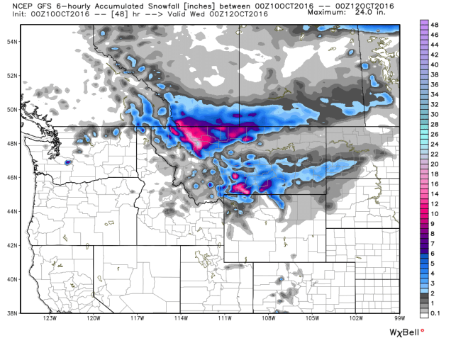
gfs_6hr_snow_acc_nw_9
The first snowstorm of the season is expected across the Northern Rockies today and Tuesday. We don’t have to worry about snow yet. Image provided by WeatherBell.


Monday: Becoming mostly sunny and cool with diminishing winds. High 55-62.

Monday night: Clear skies. Low 34-41, with some frost likely in the normally colder locations.

Tuesday: Sunshine and a few clouds. High 58-65.

Tuesday night: Clear to partly cloudy. Low 40-47.

Wednesday: Partly to mostly sunny. High 60-67.

Thursday: Becoming partly to mostly cloudy with a chance of late-day showers. High 64-71.

Friday: Partly to mostly sunny, breezy, and cooler. High 55-62.

Saturday: A mix of sun and clouds. High 52-59.

Sunday: Mostly sunny. High 56-63.

Is Matthew About to Get Loopy?

“Just when they think they got the answers, I change the questions!” – Roddy Piper


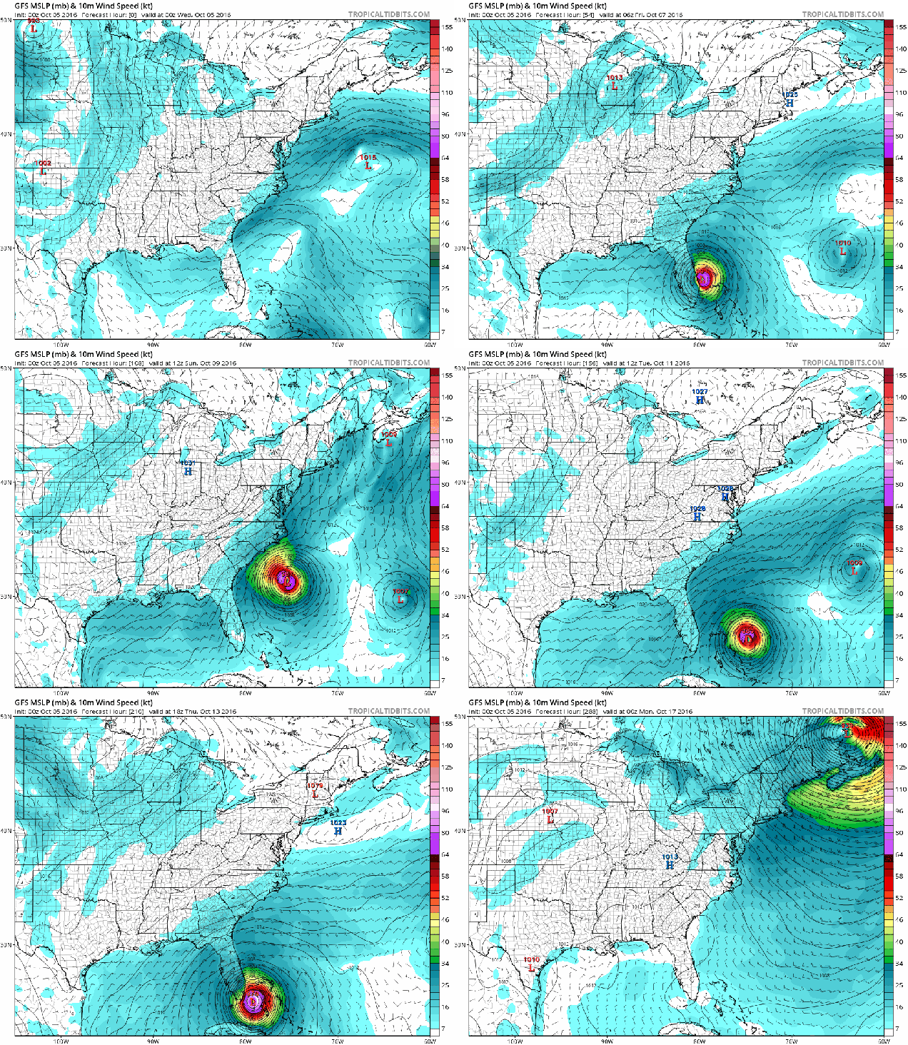
At this time yesterday, we were gaining more and more confidence in our forecast for Matthew. Then the midday models started rolling in, and we started scratching our heads. Instead of coming close to Florida and then heading up the coast, passing south and east of New England, the models started doing some wacky things. First, one of them had it menace the Southeast, then do a big loop back into the Bahamas before hitting Florida again in a much-weakened state. Then, another model did something similar. “It’s just two outliers” is what we thought, the rest still bring it up the coast. We were still fairly confident in our forecast. Then, the GFS model came out around midnight:

gfs_mslp_wind_eus_fh0-288-1
GFS model forecast loop from early Wednesday morning, October 5. Loop provided by Tropical Tidbits.

At that point, our forecast went right out the window.What seemed like an anomaly from one or two models, was quickly becoming the consensus. The GFS model, which had been very consistent with a track up the East Coast, suddenly changed gears, and had Matthew threaten Florida and the Bahamas not once, but twice. Oh, it still brought Matthew up the coast, bringing rain and gusty winds to parts of New England for the weekend, but now it was doing it NEXT weekend, not this weekend.

al142016
Model forecasts for the track of Hurricane Matthew from midday October 5. Image provided by the University of Wisconsin.

Not all of the models are showing this loop, but as you can see in the image above, there are several that do now. Before we get into what we think might happen, we’ll get into what is causing this peculiar forecast. Looking at the upper atmosphere this morning, we see a trough of low pressure across much of the West, and a ridge of high pressure in the East. There’s also a pretty strong jet stream moving into the West Coast and into the Rockies, before it makes a sharp left turn in the Mississippi Valley.

upacntr_300
Upper-air analysis for 300mb (approximately 30,000 feet) from 8am on October 5. Image provided by the National Center for Atmospheric Research.

As this trough of low pressure moves eastward, the models had been projecting that it would strengthen and sharpen up, in effect “capturing” Matthew as the trough neared the East Coast. The southerly winds ahead of the trough would drive Matthew northward or northeastward, and bring it up the coast. Instead, the models are now showing that this trough will actually weaken as it moves eastward, and flatten out. As a result, high pressure will build back in, blocking Matthew from moving northward. This would turn Matthew back towards the south and let it mill around in the Bahamas. Not all of the models are showing this scenario. Some still have the trough just strong enough to draw Matthew northward enough that the westerly winds of the jet stream are able to push it out to sea once it gets up towards the Carolinas.

This leads us to more questions, which is where the quote at the top of the post comes in.If Matthew does not get pulled north and head out to sea, then what does its future hold? Some models have it loop around, back into the Bahamas, then back towards Florida before turning northeast and heading up the coast again next week. Another one sends it back into Florida as a much weaker tropical storm, then across the state and into the Gulf of Mexico where it eventually weakens and dissipates. At this point, we’re back to “wait and see” mode.

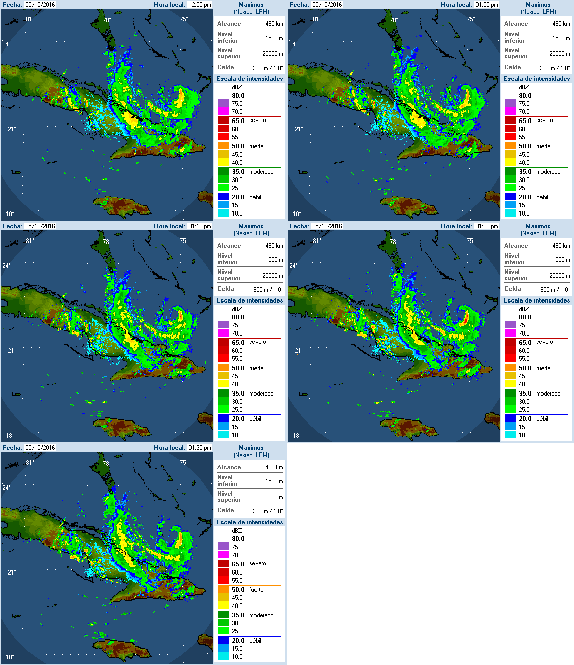
cmwmaxw01a
Radar loop from Camaguey, Cuba showing the eye of Hurricane Matthew. Image provided by Instituto de Meteorología de la Republica de Cuba

What we do know is this: There are hurricane warnings in effect for much of Florida and the Bahamas. Hurricane Matthew is still a Category 3 storm with top winds near 120 mph this afternoon. It is going to move through the Bahamas over the next 24 hours, and then come dangerously close to the Atlantic coast of Florida, with landfall a possibility, but not definite. It will likely head northward, bringing gusty winds and heavy rain to much of eastern Florida, southeastern Georgia, South Carolina, and southeastern North Carolina over the next few days. After that? That’s a really good question that we just can’t answer right now.


Weekly Outlook October 3-9, 2016

There’s not much going on in the weather world right now is there? OK, we’re know you’re not that naive. We’ll get to the update on Matthew in a moment. Much of the remainder of the forecast is actually pretty simple.

The gloomy pattern we’ve been in will continue for one more day before the upper-level low pressure system responsible for it finally lifts out. High pressure starts to build in on Tuesday, and we stay dry through Friday.

After that? Well, that’s the $64,000 question, isn’t it? Here’s what’s going to be happening with the atmosphere. A cold front will start to approach from the west, while an upper-level trough of low pressure moves from the Plains states into the Great Lakes. By early Saturday, Matthew should be off the North Carolina coastline.

gfs_z500_mslp_eus_23-1
GFS forecast for Saturday morning October 8. Note the trough of low pressure (green colors) moving into the Mississippi Valley, the ridge of high pressure off the East coast (red and orange colors), and Matthew just off the NC coast. Image provided by Tropical Tidbits.

How strong that trough is, as well as how strong the ridge of high pressure off the East Coast is, will determine where Matthew goes. The GFS (pictured above), sends the storm north-northeastward, as the trough pulls it in. Other models, such as the ECMWF, do not have a strong trough, and as such, it builds the ridge back in, stalling Matthew’s northward progress, and letting it mill around off the Carolina coast for a few days. Other models don’t build up the ridge to the east, and thus let Matthew head northeastward, farther out to sea, before the trough captures it and pulls it northward well east of New England. The upper-level energy that will help determine how deep that trough gets is still off the West Coast. Once it gets into the West Coast, and an area where there is a lot more data to feed into the models, they should start to converge on a solution, and thus give us a better idea, or at least a little more confidence, as to what will happen.

12_es1
GFS Ensemble forecast tracks for Hurricane Matthew. Image provided by Dr. Brian Tang, University at Albany.
12_es3
ECMWF Ensemble forecast tracks for Hurricane Matthew. Image provided by Dr. Brian Tang, University at Albany.

Before we get to what, if any, impacts Matthew may have on our area, there’s another problem. The models are picking up on this, but we don’t think they’re hitting it hard enough. We told you that a cold front would be coming in from the west. This is going to set up what is called a “Predecessor Rainfall Event” or PRE for short. This often happens up here ahead of tropical systems, and can even occur when the tropical system doesn’t even get within 500 miles of New England. This was the case with the devastating flooding we had in 1996 from Hurricane Lili and again in October of 2005. This also happened last year in South Carolina with offshore Hurricane Joaquin. In other words, even if Matthew does not come close to New England, we could be looking at extremely heavy rainfall around here on Saturday ahead of a cold front. Earlier this summer, we told you about an old rule of thumb “When in drought, leave it out”, when talking about rainfall. Well, we’ve got another rule of thumb for you “Droughts end in floods”. Just look at Texas from earlier this year to see that play out.

Monday: Partly to mostly cloudy with more showers and maybe even a rumble of thunder possible. High 64-71.

Monday night: Mostly cloudy, chance for a few more showers. Low 50-57.

Tuesday: Becoming partly sunny. High 58-65.

Tuesday night: Partly cloudy.  Low 44-51.

Wednesday: Partly to mostly sunny (yes, really, we mean it). High 60-67.

Thursday: Mostly sunny. High 65-72.

Friday: Sunshine and a few clouds. High 67-74.

Saturday: Becoming cloudy with rain developing. The rain could be heavy, especially at night. High 64-71.

Sunday: Cloudy with rain likely, possibly heavy at times. If Matthew is close enough, it will also be very windy. High 60-67.

Will Matthew Cause Mayhem?

By now you’ve probably heard, there’s a new storm in the Atlantic, and it’s named Matthew. OK, you probably knew that, because the hype machine from the media has gone into overdrive for the past few days. Why has that happened? Some of the computer forecast models have indicated that there’s a possibility that Matthew could hit the East Coast? How likely is that? We’ll delve into that shortly. First, we’ll get into what we do know.

vis_lalo-animated
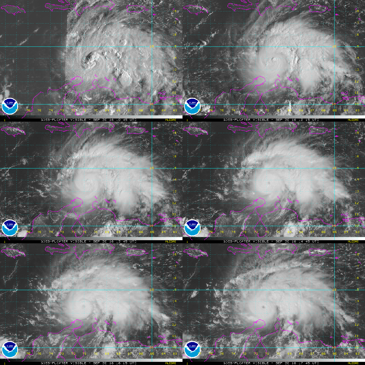
Satellite loop of Hurricane Matthew from Friday afternoon September 30. Loop provided by NOAA.

As of 2pm EDT on Friday, Matthew was a Category 3 Hurricane on the Saffir-Simpson scale, with maximum sustained winds of 120 mph.The storm was centered a little less than 100 miles off the northern coast of Colombia, and was moving off towards the west-southwest at 12 mph. A Tropical Storm Warning is in effect for the coast of Colombia from the Colombia/Venezuela border to Riohacha.

It is actually pretty rare to have a storm impact the ABC Islands (Aruba, Bonaire, Curacao) and northern South America. There have been a few wind gusts to near tropical storm force in Aruba and Bonaire today, but for the most part, it’s just been a breezy and cloudy day in an area that usually is sunny and warm. When Matthew crossed the island of Martinique a few nights ago, it produced sustained winds of 40 mph and a gust to 60 mph at the airport in St. Pierre, with reports of gusts of up to 89 mph on the island. There was several reports of damage across the island.

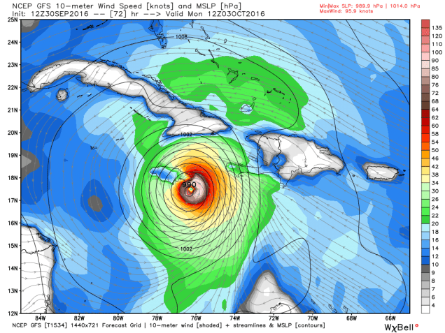
OK, that’s what we know. Here’s what we’re fairly sure about. Matthew should turn more towards the northwest and eventually north this weekend with some more strengthening possible. It may become a category 4 hurricane. Unfortunately, it is also going to pass very close to Jamaica late Sunday and early Monday. It may even make landfall on the island. Even a glancing blow will likely result in widespread damage across the island. After that, Matthew should continue northward, and it will pass very near or over extreme western Haiti or eastern Cuba before heading into the Bahamas. Some slight weakening is possible due to interaction with the land areas, but Matthew should still be a strong hurricane (Category 2 or 3) when it enters the Bahamas.

gfs_mslp_uv10m_haiti_13
GFS model forecast for sea-level pressure and wind speeds for Monday morning October 3. That wouldn’t be a good time to be in Kingston, Jamaica. Image provided by WeatherBell.

Now, the part that nobody knows with any certainty – what happens after Matthew gets into the Bahamas. This is the big question, and a lot of it has to do with what the upper-level pattern looks like. A trough of low pressure will be starting to move out of the Northeast while another one moves into the Great Plains. In between, a ridge of high pressure will be moving into the East. Exactly how quickly these features move eastward will determine which way Matthew goes.

12_es1
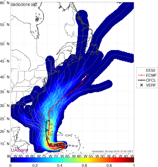
Forecast tracks for Matthew from the GFS Ensemble. Image provided by Brian Tang, University at Albany
0_es3
Forecast tracks for Matthew from the ECMWF Ensemble. Image provided by Brian Tang, University at Albany

As you can see from the images above, there are dozens of possibilities as to where Matthew can go. Based on the most recent model runs, a track through the Bahamas and then northward off the Carolinas is the most likely outcome, but there are still some models that have the storm stall in the Bahamas or even drift closer to Florida or possibly into the Gulf of Mexico. Once it gets up towards the Carolinas, there are even more possibilities to consider. The storm could continue up the coast and threaten the Northeast. It could start to turn northeastward and threaten Atlantic Canada. It could head harmlessly out to sea. At least one model shows it doing nearly all of the above! This model has it head out to sea, then hook back northwestward, and head towards eastern New England and Nova Scotia/New Brunswick.

At this point, we really have to wait and see how the pattern evolves before we’ll have a better idea as to what Matthew is going to do. If it is going to impact the Northeast, the time frame would be towards next weekend.So, keep an eye on Matthew’s progress if you have plans for that time frame.

Beneficial Rain Is On The Way….Or Is It?

If you’ve lived around here long enough, at some point you start to think to yourself that winter won’t ever end. You start to dream about vacations in tropical locations, or better yet, sitting in your own backyard on a sunny summer afternoon. This past summer, you probably didn’t have many complaints, as there were plenty of those sunny, warm afternoons to go around. However, because it was so sunny and warm, much of the region is now in the midst of a very serious drought.

20160920_northeast_trd
Yup, it’s been really dry for a while now. Image provided by the National Drought Monitor.

A persistent ridge of high pressure kept the Northeast dry and warm through much of the Spring and Summer. Most of the cold fronts that tried to move through the region were starved for moisture, thus their main effects were to cool temperatures and lower humidity for a day or two. Thunderstorm activity was common, but aside from localized downpours, there really hasn’t been a widespread heavy rain event across much of the region for several months. That could be changing this week.

500wh-conus
GFS forecast showing an upper-level low pressure area sitting over the Appalachians Friday morning. Image provided by Pivotal Weather.

A slow-moving cold front will move across the region on Tuesday, bringing showers with it. While the rain likely won’t be too heavy, it should be widespread, which is good news for an area that needs all the rain it can get. The front will likely stall out right along the coastal plain, which may keep the shower activity going into Wednesday right along the coast. However, changes in the weather pattern are coming that promise to bring even more rain to the area.

An upper-level low pressure system will drop southward from the Great Lakes and take up residence across portions of the Ohio Valley and Appalachians. It will likely stay there for several days, before lifting out to the northeast this weekend. However, with the upper-level low pressure area just sitting there, low pressure will essentially remain in place at the surface as well across the same area. This will result in periods of rain and showers across much of the area right through the week. While the rain may be briefly heavy at times, persistent rainfall over several days can add up, with some areas possibly receiving 1-3 inches of rain between Tuesday and Friday, with some heavier amounts possible. Rainfall deficits in this area are on the order of 5-10 inches, so much more is needed, but this is definitely a good start.

qpf_acc-us_ne
GFS model forecast for rainfall through Saturday morning. Doesn’t look good for Northern New England. Around here? We’ll see. Image provided by Pivotal Weather.
So, if you’re in places like Pittsburgh, Syracuse, or Atlantic City, it’s going to be a pretty dismal week. Around here? Well, that’s not an easy question to answer. With the low setting up well to the southwest of the area, high pressure will try to build in from the north. This will bring cool and dry conditions into much of northern New England this week. As for southern New England, where the effects of the drought are the most pronounced, the forecast depends entirely on where the low and high set themselves up. If the high is the dominant feature, much of southern New England can expect dry and cool conditions, with gusty east to northeasterly winds bringing some clouds and drizzle in off the Atlantic at times. If the low sets up a bit closer to the region, then the forecast will trend more towards a damp scenario with periods of showers for the next several days. At this point, it’s still a little too early to tell which scenario will be the correct one. The pattern for the past several months would suggest that we stay drier. However, given what normally happens this time of year, and how the forecasts related to upper-level low pressure areas never go as planned, we wouldn’t be surprised at all if it ends up being a gray, damp week around here too. However, that’s by no means a certainty, so keep an eye on the forecast before you make any plans.

Weekly Outlook: September 26-October 2, 2016

Fall is definitely in the air as we start this week, with some frost in places to start the day. With the change in seasons, we may start to see a change in the pattern too, but there is plenty of uncertainty that goes with that. We are fairly certain about what will happen for the next few days though. High pressure moves offshore today with sunshine and seasonably cool temperatures once again. A cold front moves in tomorrow, with some showers likely. After that, things get quite tricky.

500wh-conus
Cutoff low pressure systems are notoriously tricky to forecast and usually keep us cool and damp. This one might do just that. Image provided by Pivotal Weather.

That cold front will likely stall out near or just south of New England, and high pressure will try to build in from the north. At the same time, and upper-level low pressure system will settle into the Appalachians and remain in place for much of the rest of the week. Exactly where it sets up has big implications on the forecast though.If the high is able to build in enough, we’ll stay mostly dry, albeit it cool and breezy with an easterly flow bringing in some drizzle at times off the Atlantic. If the low sets up a bit farther north, we may have to deal with episodes of showers from Wednesday right through to the weekend. At this point, we’re not completely sure which way is right, so this is a low confidence forecast. Recent history says we stay dry, but climatology and the normal tendencies with the models say we more than likely would be cool and damp. For now, that’s the direction we’re leaning, but keep in mind, things could end up considerably different.

frost
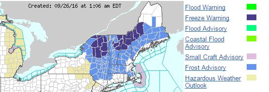
Frost advisories and freeze warnings are in effect this morning across much of the Northeast. Image provided by NOAA.

Monday: Sunny and chilly to start the day, but clouds start to filter in during the afternoon. High 61-68.

Monday night: Becoming cloudy with showers developing after midnight.Low 51-58.

Tuesday: Showers taper off and end from northwest to southeast, lingering longest near the south coast. Some sunshine may develop late in the day across the interior. High 67-74.

Tuesday night: Clearing skies well inland, remaining partly to mostly cloudy near the coast, with a few showers still possible across the Cape. Low 49-56.

Wednesday: More clouds than sunshine, a few spotty showers or drizzle may develop, especially near the south coast. High 63-70.

Thursday: Mostly cloudy and breezy with showers possible. High 61-68.

Friday: Cloudy and breezy with more showers and drizzle possible. High 60-67.

Saturday: Intervals of clouds and sunshine, chance for more showers. High 63-70.

Sunday: A mix of sun and clouds, chance for some showers. High 62-69.

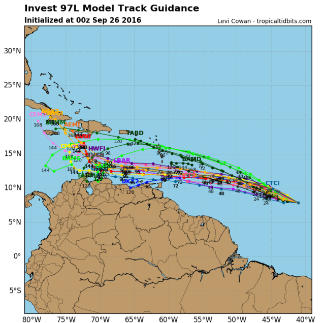
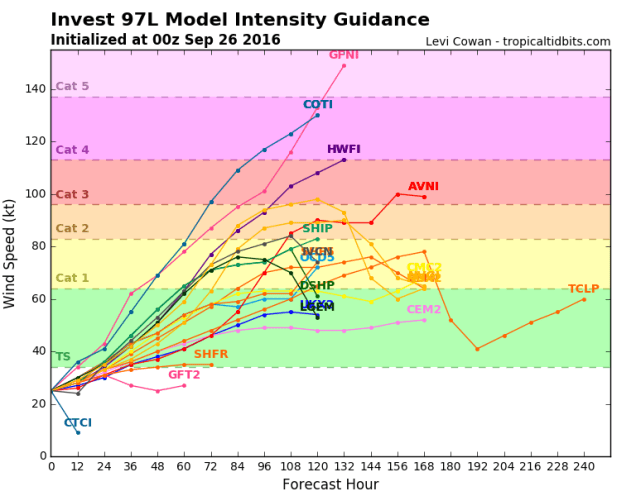
On another note, keep an eye on the tropics. There’s a disturbance that’s about 1300 miles east-southeast of the Lesser Antilles early this morning that bears watching. There’s a decent chance it could become a tropical depression later this week before moving into the Caribbean. Once it gets into the Caribbean, some models show some modest strengthening, while others develop the storm into a monster (see below). It’s what the storm does more than a week out (assuming it develops) that bears watching. Some models have it keep cruising west-northwestward across the Caribbean and into the Gulf of Mexico, and from there who knows. That would be bad for a lot of reasons. One silver lining though would be that after it moves inland and weakens it could bring us some beneficial rainfall. Other models have it turn northward, cross Hispaniola or Cuba, then head out into the open Atlantic. Still, there are other models that have it cross Hispaniola, then head northward, up the East Coast. We don’t have to explain to you why that wouldn’t be good at all. While the odds of this system doing anything up here are fairly remote, there’s a chance that it could impact the US at some point. Again, don’t worry too much, but keep an eye on what this system does, if it does anything at all.

97l_tracks_latest
Computer model forecasts for the track of a tropical disturbance in the Central Atlantic. Image provided by Tropical Tidbits.
97l_intensity_latest
Computer model forecasts for the intensity of a tropical disturbance in the Central Atlantic. Image provided by Tropical Tidbits.