Once again, we’ve got another fairly quiet week coming up across the region, with little to talk about. That’s a good thing, because we’re into the middle of November now, and it’s only a matter of time until things get more complicated. (Don’t worry, we’re not going to use the S-Word).

We start the week off with high pressure in control, giving us a sunny, mild day today. Tuesday is the complicated day of the week. A storm system will move up the coast, giving us some rain and cooler temperatures, mainly north of Boston. Of course, “cooler” is a relative term, as even though Tuesday will be about 10 degrees cooler than Monday, we’ll still be near or a little above normal for mid-November. South of Boston, temperatures could spike back into the 50s to near 60 again on Tuesday, depending on the exact track the storm takes. Once the storm goes by on Wednesday, high pressure builds back in, with drier weather for much of the remainder of the week, along with another warming trend. In fact, we wouldn’t be surprised at all if temperatures on Friday and Saturday ended up even warmer than what we have in the forecast below. Another system moves in this weekend with some showers and cooler conditions, but again, things could be a lot worse at this time of year.
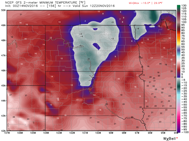
How much worse could it be? Consider this. The cold front that will give us showers over the weekend will be extending southward from a storm moving into northern Quebec. Before it gets there, it will be quite a strong storm moving across the Nation’s mid-section later this week. It will likely produce blizzard conditions across the Dakotas, with heavy snow, wind gusts in excess of 50-60 mph, and very cold temperatures. How cold? How does sub-zero low temperatures sound next Sunday morning with 1-2 feet of fresh snow cover sound? Aren’t you glad that you don’t live in Bismarck, North Dakota?

Monday: Mostly sunny for much of the day, clouds start to filter in by evening. High 57-64.
Monday night: Becoming cloudy, showers developing towards daybreak along the south coast. Low 36-43.
Tuesday: Cloudy and breezy with showers likely, thought a few pockets of steadier and heavier rain are possible. High 47-54 north and west of Boston, 54-61 from Boston southward.
Tuesday night: Cloudy with showers tapering off and ending. Low 44-51.
Wednesday: Morning clouds give way to increasing afternoon sunshine. High 53-60.
Thursday: Mostly sunny. High 50-57.
Friday: Plenty of sunshine. High 52-59.
Saturday: Mostly sunny to start, then clouds start to increase late in the day. High 50-57.
Sunday: Mostly cloudy with a chance of showers. High 47-54.
