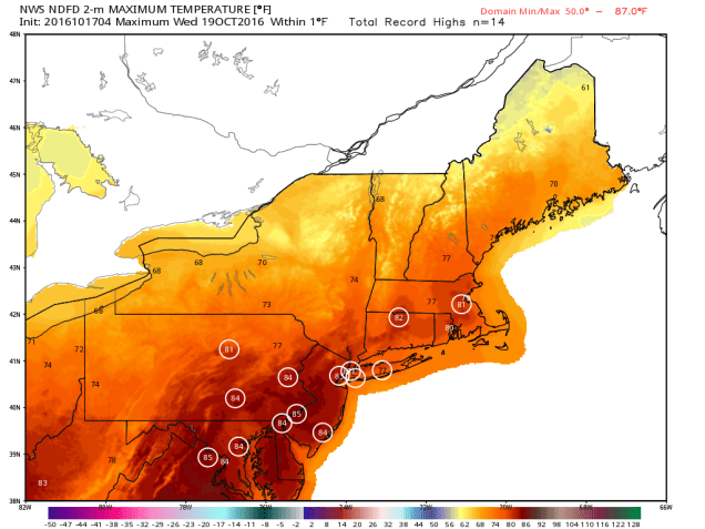
As you can probably guess from the video above, we’ve got some changes coming this week. A weak cold front will drop down into the region today, with just a chance for a few showers as it moves through. That front will lift back northward as a warm front as we head into Tuesday, bringing us some Indian Summer weather for midweek. The front may take its time heading northward, so the warmer air may not reach the Seacoast of New Hampshire until late in the day. Once that warmer air settles in, we could even set some record highs, especially on Wednesday. A cold front moves through late Wednesday, bringing some cooler conditions in for Thursday, but little rainfall.
But wait, things change again after that! That cold front stalls out to our south, and a wave of low pressure rides along it. At the same time, an area of low pressure may try to move up the East Coast. As a result, Friday could be a rather wet day. How much rain we get depends on where the front is located and how close the coastal low comes to New England. It appears as though the front may lift back northward again as warm front, which would mean another mild day, but also focus most of the rain across northern New England.
That’s not all though, as there are even more changes next weekend! The coastal low pulls away from the region and the cold front moves well offshore, with high pressure starting to settle in. That will bring much colder air into the region by Sunday, despite some sunshine. How cold? There might even be some snow showers across the higher elevations of northern New England. That chilly air likely hangs around into the first part of the next week.
Monday: A mix of sun and clouds, slight chance for a shower. High 70-77.
Monday Night: Partly to mostly cloudy. Low 52-59.
Tuesday: Partly to mostly sunny and becoming breezy. High 75-82, though it could stay cooler along the NH Seacoast and possibly the North Shore.
Tuesday Night: Clear skies, breezy. Low 59-66.
Wednesday: Sunshine and a few clouds. High 75-82.
Thursday: Plenty of clouds, slight chance for a few showers late in the day. High 63-70.
Friday: Mostly cloudy with showers likely. High 63-70.
Saturday: More clouds than sunshine, more showers possible, mainly in the morning, becoming breezy. High 57-64.
Sunday: Sunshine and some afternoon clouds, breezy. High 54-61.
