Heat and humidity will return this week, but not to the extent that we experienced recently.
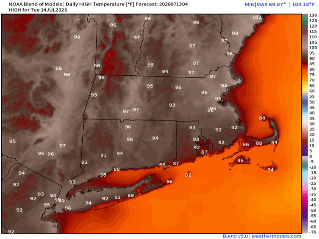
High pressure slides offshore today, with increasing temperatures and humidity levels. A pop-up shower or thunderstorm can’t be ruled out, but they’ll be few and far between. Tuesday looks even hotter, except along the South Coast and Cape Cod, with southwest winds act as a seabreeze. A cold front moves through early Wednesday with little fanfare, but it will bring some drier air into the region. It will remain hot, and with northwest winds, the heat will get all the way down to the South Coast. Another front moves through on Thursday, possibly producing a shower or thunderstorm, but most places will remain dry, which means we don’t get much drought relief. Cooler air settles in for Friday. The weekend is a bit uncertain at this point. A low pressure system may move out of the Great Lakes and towards New England with some showers and thunderstorms at some point, but the timing, and whether the system even materializes, is still a question.

Monday: Sunshine and some afternoon clouds, slight chance for a shower or thunderstorm, breezy. High 82-89, cooler across the South Coast and Cape Cod.
Monday night: Clear to partly cloudy. Low 64-71.
Tuesday: A mix of sun and clouds, breezy, humid. High 90-97, cooler across the South Coast and Cape Cod.
Tuesday night: Clear to partly cloudy, muggy. Low 73-80.
Wednesday: Partly to mostly sunny, breezy, not as humid. High 88-95.
Wednesday night: Clear skies. Low 64-71.
Thursday: A mix of sun and clouds, slight chance for a shower or thunderstorm, breezy. High 84-91.
Thursday night: Clear skies. Low 61-68.
Friday: Mostly sunny. High 80-87.
Saturday: Partly sunny, showers and thunderstorms possible late in the day. High 78-85.
Sunday: Partly sunny, chance for some showers and thunderstorms. High 77-84.

