Weekly Outlook: October 24-30, 2016

In the past several days, we’ve had 80-degree temperatures setting record highs, torrential downpours leading to flooding, several inches of snow across the higher elevations, and wind gusts to 60 mph across the region. Believe it or not, there’s a technical term for all of this: “October” While we’re still in October, things will be a lot less volatile during the upcoming week.

sf1_today
Parts of Northern New England received several inches of snow Saturday night, especially at the higher elevations. Image provided by NOAA.

We’ll start the week off with a little bit of rain as a weak system moves across the region. The rain will be mainly confined to areas south of the Mass Pike, and should be all done before many of you get to work Monday morning. It will remain windy into Tuesday as the storm that brought us the heavy rain Friday continues to sit and spin across southeastern Canada. High pressure then builds in, giving us dry but rather cool conditions for mid-week.The next system gives us some rain Thursday into early Friday. While there could be some downpours, we’re not looking at anything like what we saw Friday night. High pressure then builds in for the weekend, but another storm looks to approach late Sunday night and into Halloween. Right now, it looks like the rain will be out of here in time for trick-or-treaters, but we’ve got plenty of time to keep an eye on that system.
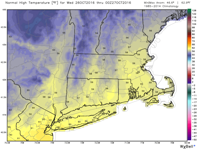
ndfd_t2max_climo_massachusetts_3
On average, high temperatures should be in the upper 50s to near around here in late October. Much of the upcoming week will see highs 10-15 degrees below normal. Image provided by WeatherBell.

Monday: Showers in the morning, then becoming partly sunny and windy in the afternoon. High 52-59.

Monday night: Clear to partly cloudy and breezy. Low 32-39.

Tuesday: Partly to mostly sunny, still breezy. High 43-50.

Tuesday night: Clear skies. Low 29-36.

Wednesday: Sunshine and a few clouds. High 41-48.

Thursday: Becoming mostly cloudy with showers developing late in the day, becoming a steady rain at night. High 46-53.

Friday: Rain ending in the morning, then becoming partly sunny and breezy. High 53-60.

Saturday: Mostly sunny. High 50-57.

Sunday: Becoming mostly cloudy with showers developing at night. High 48-55.

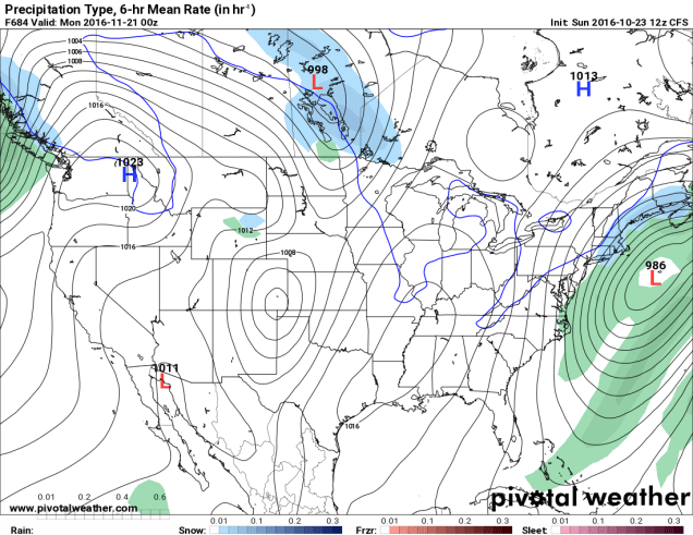
Finally, since we’re getting to the time of year where people start wondering when the snow will start to fall around here, we figured we’d try to answer that. Now, we understand that some of you ask this question because you love winter, and some ask because you dread it and want to know when your luck will run out. There’s a model called the CFS, that actually goes out several months. We put zero stock in this model, and are only presenting it for entertainment purposes only. In other words, the odds that this model is right are roughly the same odds that the Cubs win the World Series the Jets win the Super Bowl this year.
prateptype_cat-conus
CFS model forecast for Sunday evening November 20, showing the first snowfall for Southern New England. We’re just showing you what the model has, not that we believe it. Image provided by Pivotal Weather.

Weekly Outlook October 17-23, 2016

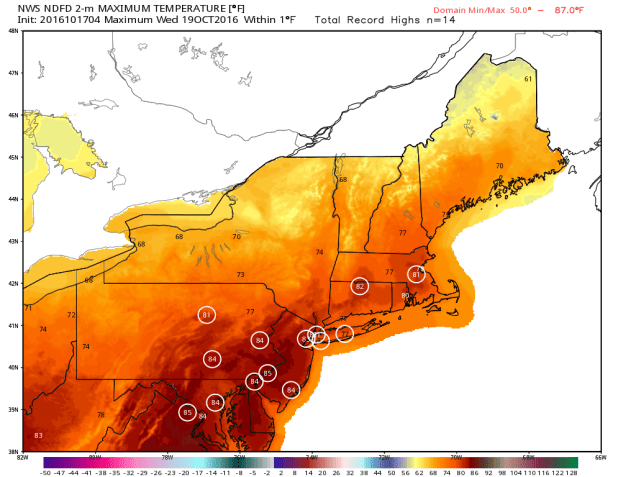
As you can probably guess from the video above, we’ve got some changes coming this week. A weak cold front will drop down into the region today, with just a chance for a few showers as it moves through. That front will lift back northward as a warm front as we head into Tuesday, bringing us some Indian Summer weather for midweek. The front may take its time heading northward, so the warmer air may not reach the Seacoast of New Hampshire until late in the day. Once that warmer air settles in, we could even set some record highs, especially on Wednesday. A cold front moves through late Wednesday, bringing some cooler conditions in for Thursday, but little rainfall.

ndfd_record_hi_neng_3
Some record high temperatures are possible on Wednesday across the area. Image provided by WeatherBell.

But wait, things change again after that! That cold front stalls out to our south, and a wave of low pressure rides along it. At the same time, an area of low pressure may try to move up the East Coast. As a result, Friday could be a rather wet day. How much rain we get depends on where the front is located and how close the coastal low comes to New England. It appears as though the front may lift back northward again as warm front, which would mean another mild day, but also focus most of the rain across northern New England.

That’s not all though, as there are even more changes next weekend! The coastal low pulls away from the region and the cold front moves well offshore, with high pressure starting to settle in. That will bring much colder air into the region by Sunday, despite some sunshine. How cold? There might even be some snow showers across the higher elevations of northern New England. That chilly air likely hangs around into the first part of the next week.

Monday: A mix of sun and clouds, slight chance for a shower. High 70-77.

Monday Night: Partly to mostly cloudy. Low 52-59.

Tuesday: Partly to mostly sunny and becoming breezy. High 75-82, though it could stay cooler along the NH Seacoast and possibly the North Shore.

Tuesday Night: Clear skies, breezy. Low 59-66.

Wednesday: Sunshine and a few clouds. High 75-82.

Thursday: Plenty of clouds, slight chance for a few showers late in the day. High 63-70.

Friday: Mostly cloudy with showers likely. High 63-70.

Saturday: More clouds than sunshine, more showers possible, mainly in the morning, becoming breezy. High 57-64.

Sunday: Sunshine and some afternoon clouds, breezy. High 54-61.

Weekly Outlook October 10-16, 2016

We finally got the beneficial rain we that we really needed on Sunday. Of course, we need a lot more of it. This week, we’re not going to get it. So while you won’t need an umbrella, you will need to dig out your fall coats and/or sweatshirts, because it’s going to turn cooler.

rb-animated
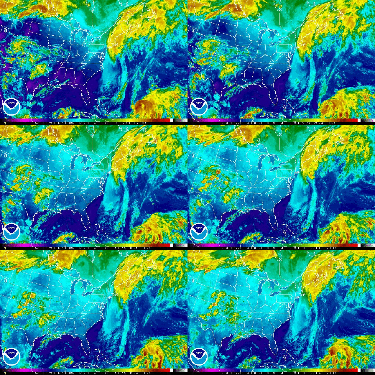
Satellite loop showing the moisture from what’s left of Matthew streaming into Atlantic Canada early this morning while Nicole starts to strengthen south of Bermuda. Loop provided by NOAA.

A cold front will continue to pull away from the region today and high pressure will build in. This will result in dry and cool conditions into at least Wednesday. By Thursday, we’ll be back in a somewhat similar pattern to what we had on Sunday. A cold front will be approaching from the west, and Hurricane Nicole will be well offshore after making a close pass to Bermuda. Unlike Sunday, Nicole should be too far offshore to have any influence on our weather, so we’ll just have to deal with scattered showers with the cold frontal passage. High pressure then builds back in for next Friday and the weekend with a return to cool and dry conditions. While we still could see some days with highs in the 70s coming up, it is becoming less and less likely that we’ll see highs reaching 80 again before March or April. It could be worse though, at least we don’t have snow in the forecast…..yet.

gfs_6hr_snow_acc_nw_9
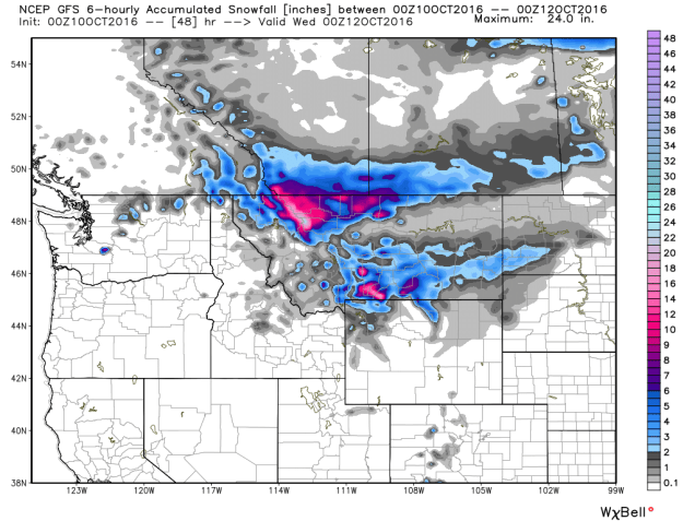
The first snowstorm of the season is expected across the Northern Rockies today and Tuesday. We don’t have to worry about snow yet. Image provided by WeatherBell.


Monday: Becoming mostly sunny and cool with diminishing winds. High 55-62.

Monday night: Clear skies. Low 34-41, with some frost likely in the normally colder locations.

Tuesday: Sunshine and a few clouds. High 58-65.

Tuesday night: Clear to partly cloudy. Low 40-47.

Wednesday: Partly to mostly sunny. High 60-67.

Thursday: Becoming partly to mostly cloudy with a chance of late-day showers. High 64-71.

Friday: Partly to mostly sunny, breezy, and cooler. High 55-62.

Saturday: A mix of sun and clouds. High 52-59.

Sunday: Mostly sunny. High 56-63.

Weekly Outlook October 3-9, 2016

There’s not much going on in the weather world right now is there? OK, we’re know you’re not that naive. We’ll get to the update on Matthew in a moment. Much of the remainder of the forecast is actually pretty simple.

The gloomy pattern we’ve been in will continue for one more day before the upper-level low pressure system responsible for it finally lifts out. High pressure starts to build in on Tuesday, and we stay dry through Friday.

After that? Well, that’s the $64,000 question, isn’t it? Here’s what’s going to be happening with the atmosphere. A cold front will start to approach from the west, while an upper-level trough of low pressure moves from the Plains states into the Great Lakes. By early Saturday, Matthew should be off the North Carolina coastline.

gfs_z500_mslp_eus_23-1
GFS forecast for Saturday morning October 8. Note the trough of low pressure (green colors) moving into the Mississippi Valley, the ridge of high pressure off the East coast (red and orange colors), and Matthew just off the NC coast. Image provided by Tropical Tidbits.

How strong that trough is, as well as how strong the ridge of high pressure off the East Coast is, will determine where Matthew goes. The GFS (pictured above), sends the storm north-northeastward, as the trough pulls it in. Other models, such as the ECMWF, do not have a strong trough, and as such, it builds the ridge back in, stalling Matthew’s northward progress, and letting it mill around off the Carolina coast for a few days. Other models don’t build up the ridge to the east, and thus let Matthew head northeastward, farther out to sea, before the trough captures it and pulls it northward well east of New England. The upper-level energy that will help determine how deep that trough gets is still off the West Coast. Once it gets into the West Coast, and an area where there is a lot more data to feed into the models, they should start to converge on a solution, and thus give us a better idea, or at least a little more confidence, as to what will happen.

12_es1
GFS Ensemble forecast tracks for Hurricane Matthew. Image provided by Dr. Brian Tang, University at Albany.
12_es3
ECMWF Ensemble forecast tracks for Hurricane Matthew. Image provided by Dr. Brian Tang, University at Albany.

Before we get to what, if any, impacts Matthew may have on our area, there’s another problem. The models are picking up on this, but we don’t think they’re hitting it hard enough. We told you that a cold front would be coming in from the west. This is going to set up what is called a “Predecessor Rainfall Event” or PRE for short. This often happens up here ahead of tropical systems, and can even occur when the tropical system doesn’t even get within 500 miles of New England. This was the case with the devastating flooding we had in 1996 from Hurricane Lili and again in October of 2005. This also happened last year in South Carolina with offshore Hurricane Joaquin. In other words, even if Matthew does not come close to New England, we could be looking at extremely heavy rainfall around here on Saturday ahead of a cold front. Earlier this summer, we told you about an old rule of thumb “When in drought, leave it out”, when talking about rainfall. Well, we’ve got another rule of thumb for you “Droughts end in floods”. Just look at Texas from earlier this year to see that play out.

Monday: Partly to mostly cloudy with more showers and maybe even a rumble of thunder possible. High 64-71.

Monday night: Mostly cloudy, chance for a few more showers. Low 50-57.

Tuesday: Becoming partly sunny. High 58-65.

Tuesday night: Partly cloudy.  Low 44-51.

Wednesday: Partly to mostly sunny (yes, really, we mean it). High 60-67.

Thursday: Mostly sunny. High 65-72.

Friday: Sunshine and a few clouds. High 67-74.

Saturday: Becoming cloudy with rain developing. The rain could be heavy, especially at night. High 64-71.

Sunday: Cloudy with rain likely, possibly heavy at times. If Matthew is close enough, it will also be very windy. High 60-67.

Weekly Outlook: September 26-October 2, 2016

Fall is definitely in the air as we start this week, with some frost in places to start the day. With the change in seasons, we may start to see a change in the pattern too, but there is plenty of uncertainty that goes with that. We are fairly certain about what will happen for the next few days though. High pressure moves offshore today with sunshine and seasonably cool temperatures once again. A cold front moves in tomorrow, with some showers likely. After that, things get quite tricky.

500wh-conus
Cutoff low pressure systems are notoriously tricky to forecast and usually keep us cool and damp. This one might do just that. Image provided by Pivotal Weather.

That cold front will likely stall out near or just south of New England, and high pressure will try to build in from the north. At the same time, and upper-level low pressure system will settle into the Appalachians and remain in place for much of the rest of the week. Exactly where it sets up has big implications on the forecast though.If the high is able to build in enough, we’ll stay mostly dry, albeit it cool and breezy with an easterly flow bringing in some drizzle at times off the Atlantic. If the low sets up a bit farther north, we may have to deal with episodes of showers from Wednesday right through to the weekend. At this point, we’re not completely sure which way is right, so this is a low confidence forecast. Recent history says we stay dry, but climatology and the normal tendencies with the models say we more than likely would be cool and damp. For now, that’s the direction we’re leaning, but keep in mind, things could end up considerably different.

frost
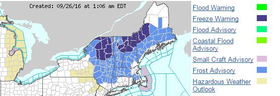
Frost advisories and freeze warnings are in effect this morning across much of the Northeast. Image provided by NOAA.

Monday: Sunny and chilly to start the day, but clouds start to filter in during the afternoon. High 61-68.

Monday night: Becoming cloudy with showers developing after midnight.Low 51-58.

Tuesday: Showers taper off and end from northwest to southeast, lingering longest near the south coast. Some sunshine may develop late in the day across the interior. High 67-74.

Tuesday night: Clearing skies well inland, remaining partly to mostly cloudy near the coast, with a few showers still possible across the Cape. Low 49-56.

Wednesday: More clouds than sunshine, a few spotty showers or drizzle may develop, especially near the south coast. High 63-70.

Thursday: Mostly cloudy and breezy with showers possible. High 61-68.

Friday: Cloudy and breezy with more showers and drizzle possible. High 60-67.

Saturday: Intervals of clouds and sunshine, chance for more showers. High 63-70.

Sunday: A mix of sun and clouds, chance for some showers. High 62-69.

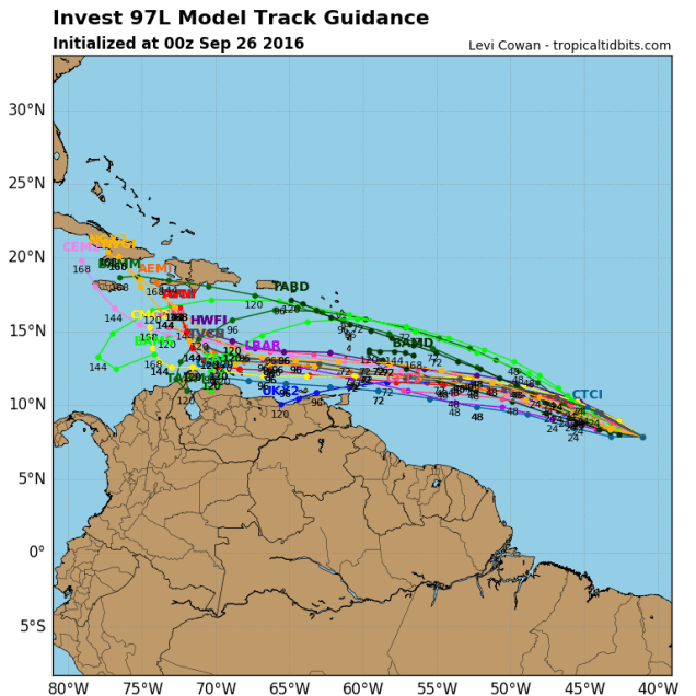
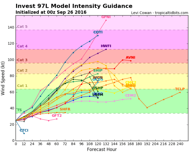
On another note, keep an eye on the tropics. There’s a disturbance that’s about 1300 miles east-southeast of the Lesser Antilles early this morning that bears watching. There’s a decent chance it could become a tropical depression later this week before moving into the Caribbean. Once it gets into the Caribbean, some models show some modest strengthening, while others develop the storm into a monster (see below). It’s what the storm does more than a week out (assuming it develops) that bears watching. Some models have it keep cruising west-northwestward across the Caribbean and into the Gulf of Mexico, and from there who knows. That would be bad for a lot of reasons. One silver lining though would be that after it moves inland and weakens it could bring us some beneficial rainfall. Other models have it turn northward, cross Hispaniola or Cuba, then head out into the open Atlantic. Still, there are other models that have it cross Hispaniola, then head northward, up the East Coast. We don’t have to explain to you why that wouldn’t be good at all. While the odds of this system doing anything up here are fairly remote, there’s a chance that it could impact the US at some point. Again, don’t worry too much, but keep an eye on what this system does, if it does anything at all.

97l_tracks_latest
Computer model forecasts for the track of a tropical disturbance in the Central Atlantic. Image provided by Tropical Tidbits.
97l_intensity_latest
Computer model forecasts for the intensity of a tropical disturbance in the Central Atlantic. Image provided by Tropical Tidbits.

Weekly Outlook: September 19-25, 2016

Do not panic! Water is going to fall from the sky today. This is actually a normal circumstance. We haven’t seen it happen that much in the past several months, but it does actually happen from time to time. There’s even a technical term for it – “Rain”.

We really need this rain, as the drought we’re in just keeps getting worse and worse. Much of the region is now in severe or extreme drought, and while today’s rain will help, it will barely put a dent in it. What we need is numerous episodes of rainfall spread out over time, and the chances of that happening should start to improve as we head deeper into fall and winter.

How much rain we get today is still a big question mark, as you can see by these two model forecasts. We could get a little, we could get a lot. At least we’ll get some rain. Of course, after today’s rain, we probably won’t see much more until a cold front comes through Friday night. Before that, we’ll have high pressure bringing us dry and warm weather once again. As for next weekend, once the front goes through, high pressure returns with more dry weather. Notice that we didn’t say more “dry and warm” weather. That’s because next weekend looks significantly cooler. How much cooler? How does highs in the 60s and lows in the 40s sound? It sounds like late September to us. While these temperatures are actually a little below normal, given how warm the past few months have been, it’ll feel like it’s a lot cooler than it really is.

20160913_northeast_trd
Latest drought update showing Severe to Extreme Drought across much of central and Southern New England. Image provided by US Department of Agriculture.

Monday: Cloudy with periods of rain and showers expected. Some localized downpours are possible. High 71-78.

Monday night: Mostly cloudy with rain tapering off and ending. Low 60-67.

Tuesday: Becoming partly to mostly sunny. High 78-85.

Tuesday night: Clear to partly cloudy.Low 57-64.

Wednesday: Sunshine and a few clouds.High 76-83.

Thursday: Partly to mostly sunny. High 75-82.

Friday: Increasing clouds, showers are possible late in the day and at night. High 77-84.

Saturday: Intervals of clouds and sunshine, just a slight chance for an afternoon shower.  High 64-71.

Sunday:Partly to mostly sunny. High 61-68.

Finally, because we like to entertain you at times, but also let you know what’s coming, we decided to end this week’s outlook with a good laugh for everyone. There’s a model called the CFS. It’s used for long-range forecasting, and it’s really not that good. However, sometimes, it’s fun to look at. While most models only go out a few days, we have a few that go out 10 to 16 days. This model however, goes out months. On one site that we use to look at this model, it goes out 32 days. Today’s Day-32 map was quite interesting, and is not likely to happen, but what the heck, let’s have some fun.

prateptype_cat-conus
CFS model forecast for the morning of October 20. Yes, that’s a wintry mix across much of New England as a powerful coastal storm passes close to Nantucket. No, we don’t believe it either. Image provided by Pivotal Weather.

Weekly Outlook: September 12-18, 2016

It’s getting tough to find ways to say the same thing every week, but we’ll try. Most of the upcoming week will be dry, but unlike much of the past few months, temperatures will start to turn cooler. Of course, this is expected, since we’re into the middle of September already and it couldn’t stay hot forever.

The week will start off on a cool note, as high pressure builds in, but as it moves offshore, we’ll warm up for Tuesday and Wednesday. Humidity will make a comeback on Wednesday as well, but a cold front will start to approach from the west. That front may give us a few showers late Wednesday and Wednesday night, but a drought-busting rainfall is not expected. After that, high pressure comes back for the end of the week, and this time, it’ll turn even cooler. How cool? Throw a blanket on the bed, because a lot of us could wake up to lows in the 40s Friday morning.Temperatures warm up again next weekend, but another cold front will start to approach, and it could bring in some showers late Sunday.

gfs_t2min_boston_19
GFS model forecast for low temperatures Friday morning. Image provided by WeatherBell.

Just remember, a couple of days of cool weather is expected at this time of year. Things could be a lot worse. Out in the Northern Rockies, over the next few days, some places, mainly above 5000 feet elevation could pick up a foot or more of snow. Yeah, you read that right.

gfs_6hr_snow_acc_nw_9
GFS model forecast for snowfall through Tuesday evening across the Northern Rockies. Image provided by WeatherBell.


No snow here for quite some time, but here are the details for the next week:

Monday: Harris K. Telemacher said it best in “L.A. Story” – Sun! Sun! Sun! High 71-78.

Monday night: Clear skies. Low 52-59.

Tuesday: Sunshine and a few clouds. High 77-84.

Tuesday night: Clear to partly cloudy. Low 59-66.

Wednesday: Morning sunshine, then increasing clouds. A few showers are possible late in the day. Humid. High 81-88.

Thursday: Becoming mostly sunny. High 67-74.

Friday: Plenty of sunshine. High 70-77.

Saturday: A mix of sun and clouds.High 73-80.

Sunday: Becoming cloudy and breezy, showers are possible in the afternoon. High 74-81.


Weekly Outlook, September 5-11, 2016

While the forecast for the upcoming week seems like it should be complicated, in reality, it isn’t, even with a former hurricane sitting just a couple of hundred miles to the south.

Hermine mills around south of the region for a few days. This gives us gusty winds, and periodic episodes of showers and steady rain into Wednesday, especially along the south coast. By Thursday, Hermine finally starts to pull away, the sun comes out, and it gets hot and humid again (summer’s not quite over yet folks). A cold front moves through Thursday night, with a few showers and thunderstorms possible.It’ll still be warm for Friday and Saturday, but without the humidity as high pressure builds in. Another front starts to approach on Sunday. Heat and humidity return ahead of it, but showers and thunderstorms accompany it as it moves through late in the day.

gfs_mslp_uv10g_boston_4
The strongest winds from Hermine are expected later today when gusts of 30-50 mph are possible across much of the region. Image provided by WeatherBell.

Monday: Cloudy and breezy with occasional showers and periods of steady rain at times. High 68-75.

Monday night: Cloudy and breezy with more showers possible, especially closer to the south coast. Low 59-66.

Tuesday:Mostly cloudy and breezy, more episodes of showers are possible. High 70-77.

Tuesday night:Mostly cloudy, still breezy along the south coast. Some additional showers may move through. Low 62-69.

Wednesday:Mostly cloudy with some more showers possible, still breezy across the Cape. High 77-84.

Thursday: Becoming partly sunny and humid. Some showers and thunderstorms are possible in the evening and at night. High 84-91.

Friday: A mix of sunshine and clouds, drier. High 83-90.

Saturday:Mostly sunny. High 83-90.

Sunday: Increasing clouds with afternoon showers and thunderstorms possible. High 82-89.

Weekly Outlook August 29-September 5, 2016

In a lot of ways, this week will be very similar to last week. That shouldn’t be a big surprise, we’ve been stuck in the same weather pattern for nearly the entire summer.

Buying-the-windshield-wipers-that-work-perfectly-for-my-car
These are called windshield wipers. You use them to clean the rain off of your windshield. Most of you probably haven’t used them much in the past few months.

Just like last week, we’ll start the week off with a cold front crossing the region early Monday. It may produce a few showers early this morning, but that’s about it. High pressure briefly builds in for Tuesday with drier conditions, then another cold front moves through on Wednesday. It may produce a few showers or thunderstorms late Wednesday. After that, high pressure builds in for the rest of the week and into the Labor Day Weekend with cooler and drier conditions. Dewpoints will likely be in the 40s again from Thursday into Saturday.

rb_lalo-animated
Satellite loop of Major Hurricane Gaston. To quote a friend “Now that’s an atmospheric heat engine.” Loop provided by NOAA.

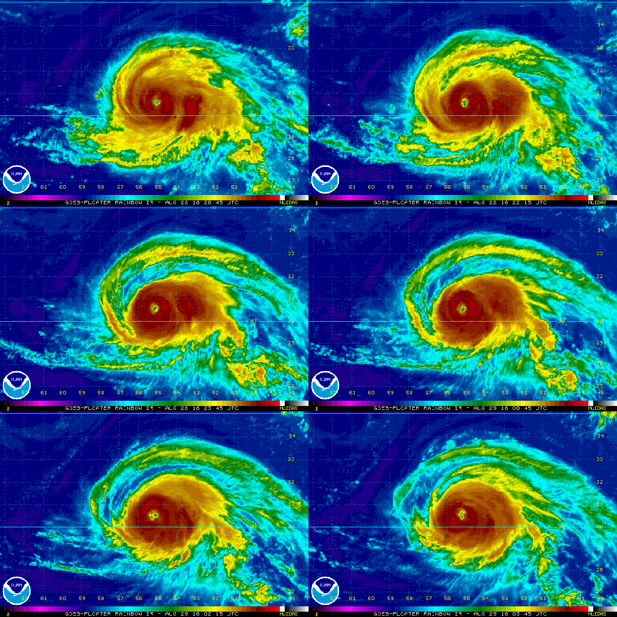
That large high pressure area building in will also be a “deflector shield” of sorts. There are currently three tropical systems in the Atlantic, and two of them, are not far from the US mainland. First we have Major Hurricane Gaston. Gaston has maximum sustained winds near 120 mph, making it a Category 3 Hurricane on the Saffir-Simpson Scale. Gaston is centered about 575 miles east of Bermuda tonight. Unless you’re in the middle of a Trans-Atlantic cruise, then you don’t have to worry about Gaston, as it will be heading out over the open Atlantic, no threat to any land areas. Gaston will start to send some rough seas our way though, so if you are planning on heading to the beach this week, be alert, as there will be a higher than now risk for riptides.

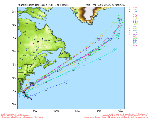
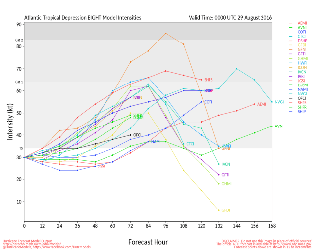
Closer to home, Tropical Depression Eight developed on Sunday. TD 8 has top winds near 35 mph, and is centered about 285 miles southeast of North Carolina. The forecast calls for TD 8 to strengthen into a tropical storm late Monday. Since it is expected to turn towards the northwest, a tropical storm watch has been issued for the Outer Banks of North Carolina from Cape Lookout to Oregon Inlet. After brushing the Outer Banks late Tuesday, it will turn more towards the north and northeast, merging with the cold front that will cross our region on Wednesday.

al082016
Model forecasts for the track of Tropical Depression Eight. Image provided by the University of Wisconsin.
al082016_inten
Model forecasts for the intensity of Tropical Depression Eight. Image provided by the University of Wisconsin.

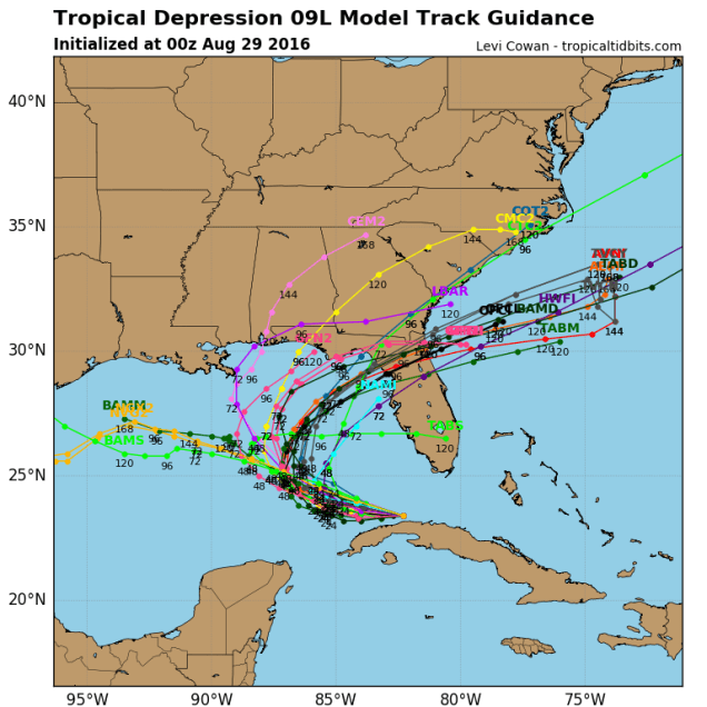
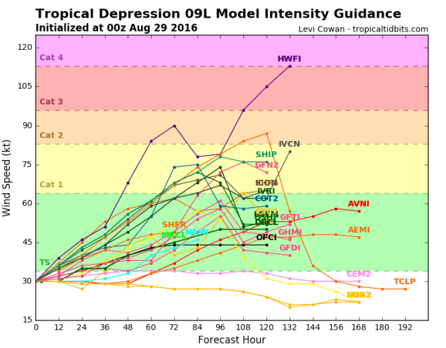
We also have Tropical Depression Nine, centered about 100 miles southwest of Key West, Florida and just off the north coast of Cuba tonight. This is the system that has been relentlessly hyped by many in the media and on the Internet (but not this site) for the past week plus as the next “Storm of the Century”. It finally developed a circulation center Sunday afternoon, and was deemed a tropical depression. If you believed many of the computer models and “Facebook Forecasters” earlier in the week, it was supposed to hit south Florida as a hurricane yesterday. Right now, it looks like the storm should turn more to the north while strengthening into a tropical storm over the next day or two. A track towards the Big Bend of Florida seems most likely at this point, but as this storm has shown already, it will do (or not do) what it wants to. Assuming it does track towards Florida, it should cross the Southeast, then emerge off the coast of Georgia or northeastern Florida. Once there, it will move over the warm waters of the Gulf Stream and could strengthen once again. However, with a big high pressure area to the north (we told you that we’d tie that in eventually), a track up the coast is unlikely. Instead, the system will likely head out into the open Atlantic.

09L_tracks_latest (1)
Model forecasts for the track of Tropical Depression Nine. Image provided by Tropical Tidbits.
09L_intensity_latest (1)
Model forecasts for the intensity of Tropical Depression Nine. Image provided by Tropical Tidbits.

So, here’s what we can expect around here right through and including Labor Day:

Monday: Chance for a few showers early, then becoming partly to mostly sunny. High 84-91.

Monday night: Clear skies. Low 56-63.

Tuesday: Partly to mostly sunny. High 78-85.

Tuesday night: Clear to partly cloudy. Low 60-67.

Wednesday: A mix of sun and clouds, chance for showers and thunderstorms during the late afternoon and evening hours.High 83-90.

Thursday: Partly sunny. High 75-82.

Friday: Intervals of sunshine and clouds.High 71-78.

Saturday: Sunshine and a few pop-up clouds.High 72-79.

Sunday: Mostly sunny. High 75-82.

Labor Day: Plenty of sunshine.High 77-84.


Weekly Outlook August 22-28, 2016

As we start off the last full week of meteorological summer, some things will remain the same as they have for months – there will be very little rainfall, worsening an already severe drought across the region. Some things will change though – humidity levels will drop at least for a few days and so will temperatures.

20160816_northeast_trd
The only place in Southern New England not currently classified as being in drought is Nantucket Island. Image provided by the US Drought Monitor.

The week will start off with a little rain. However, by the time most of you read this, the rain will already have ended. A cold front will cross the region early Monday morning with showers and possibly thunderstorms. The rain should end towards daybreak, then skies will quickly clear out as the front pushes offshore. After that, high pressure builds in, with much drier air for Monday and Tuesday. How dry? How does dewponts in the 40s sound?  Temperatures will actually be near or a little below normal as well. By Wednesday, the high moves offshore, winds become southwesterly, and both the temperature and humidity start to rise again. On Friday, another cold front sweeps across the region, with a few showers and thunderstorms expected. Cooler and drier air returns next weekend.

Umbrella-PNG-Pic
Just in case you forgot, this is called an umbrella. You use it to keep yourself dry when it rains. Most of you probably haven’t seen one for months.

Monday: Showers ending around daybreak, then becoming partly to mostly sunny, breezy, and less humid. High 76-83.

Monday night: Clear skies. Low 53-60.

Tuesday: Wall-to-wall sunshine. High 75-82.

Tuesday night: Clear skies. Low 54-61.

Wednesday: Sunshine and a few clouds. High 83-90.

Thursday: Partly to mostly sunny. High 82-89.

Friday: A mix of sun and clouds with afternoon showers and thunderstorms possible. High 83-90.

Saturday: Mostly sunny. High 79-86.

Sunday: Partly to mostly sunny. High 77-84.

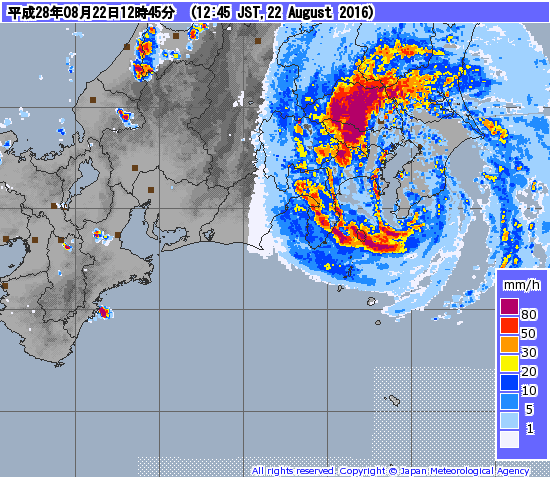
As this post is being written, Typhoon 10W (Mindulle) is making landfall very close to Tokyo. That’s probably not good. If you’re looking for an update on the massive hurricane that’s supposed to wipe out the East Coast just before Labor Day, then you’re out of luck. because it’s a fantasy that will not likely happen. Oh, we’ve got plenty of activity – Tropical Depression Fiona is dying southeast of Bermuda. There are two other areas we’re watching, one of which could become a tropical depression on Monday. The odds of either of those impacting the East Coast are still fairly small though. If there is a potential threat, we’ll let you know all about it.

201608221245-00
Radar image of Typhoon 10W (Mindulle) making landfall near Tokyo. Image provided by the Japan Meteorological Agency.