The weekend will start with heat and humidity, but that won’t last the entire weekend.
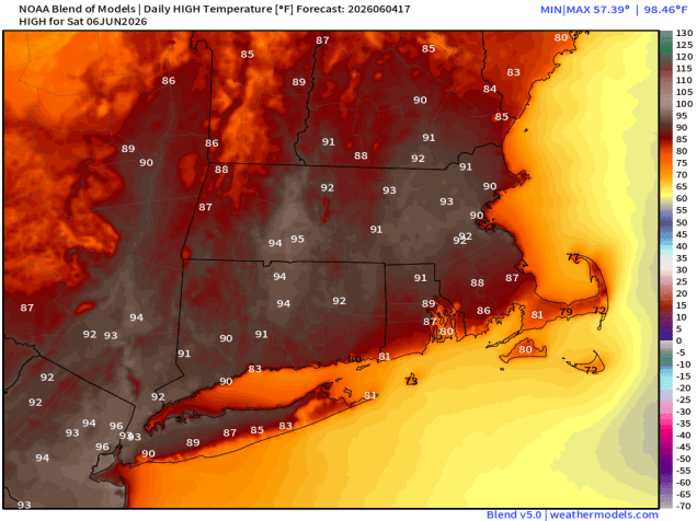
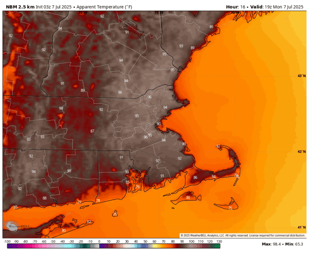
If we get enough sunshine, Saturday could be quite toasty inland. Image provided by Weathermodels.com
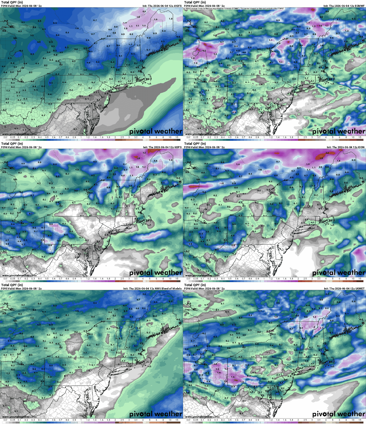
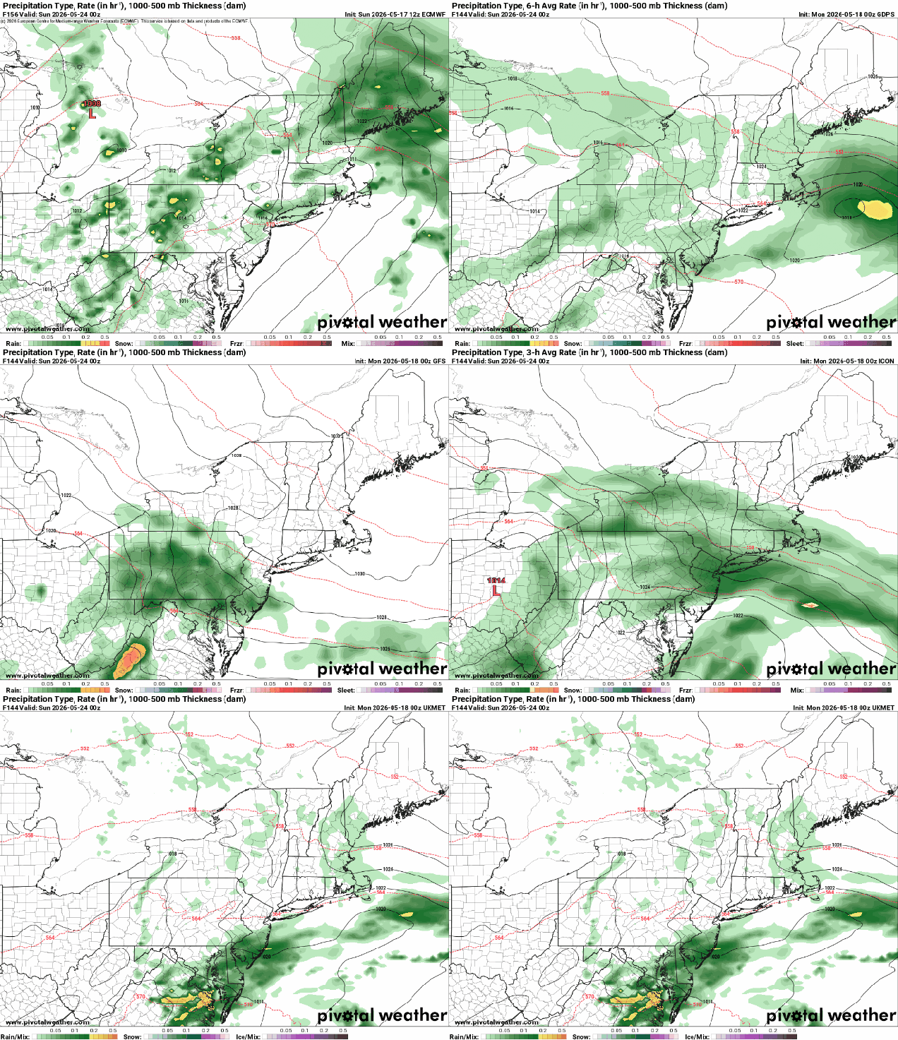
High pressure building in south of the region will result in increasing heat and humidity for Friday and Saturday. While we’ll have a few clouds around during the day on Friday, they’ll become more widespread on Saturday as a cold front begins dropping southward from Canada. A shower or thunderstorm is possible Saturday afternoon, but most of the activity should stay well north and west of our area. Showers and thunderstorms should become more widespread Saturday evening and night. A wave of low pressure will ride along the front on Sunday, bringing in more showers with much cooler temperatures, especially near the coast. We’re not expecting a soaking rain, but any rain we get will help with the ongoing drought. Unfortunately, the rain will fall on Sunday, so it will lead to a lot of complaints about another rainy weekend, despite the fact that most of Saturday will be dry. High pressure builds in for Monday with drier weather along with seasonably mild conditions.
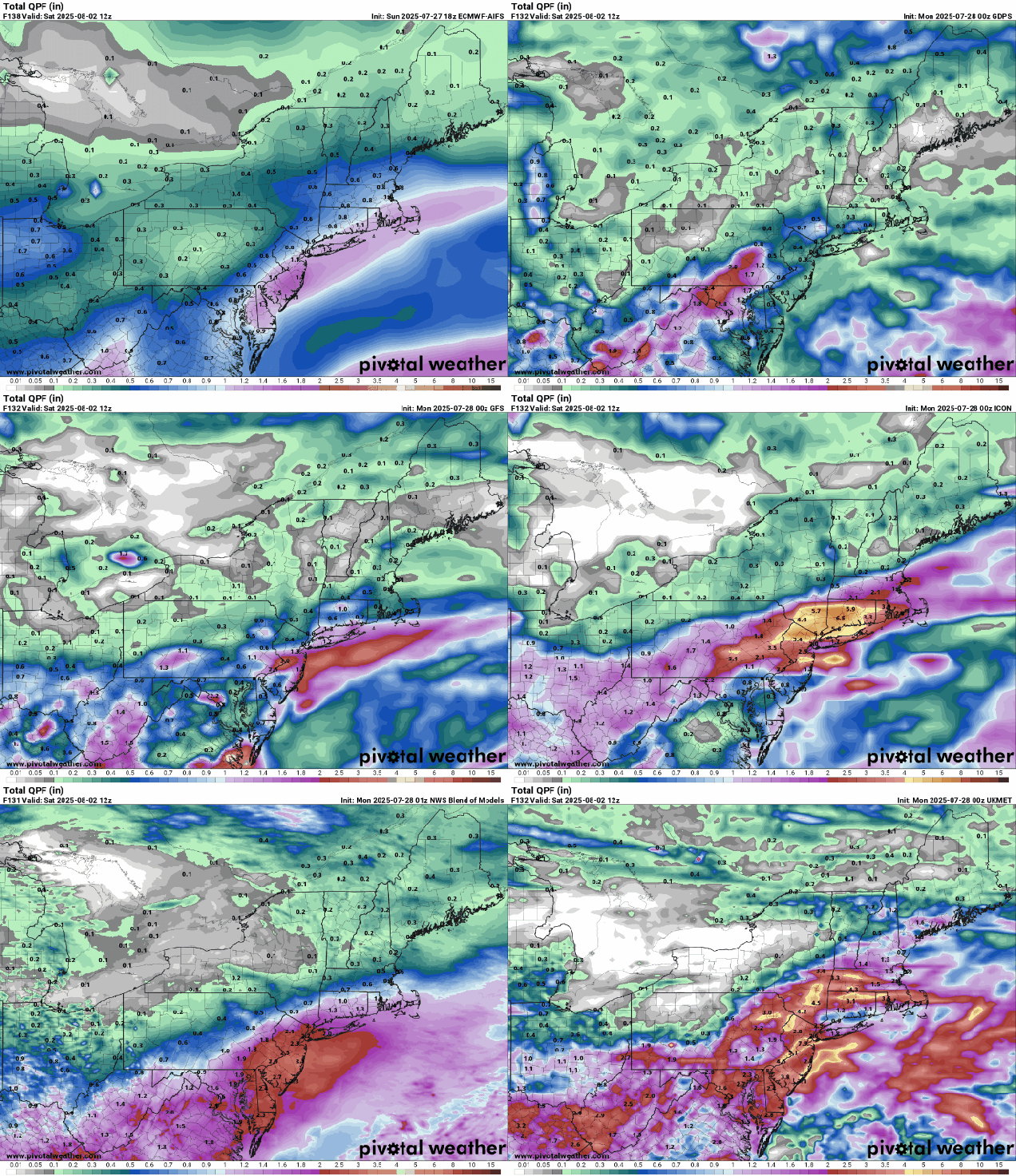
Most of the models aren’t forecasting heavy rain for Saturday night and Sunday. Images provided by Pivotal Weather.
Thursday night: Clear to partly cloudy. Low 55-62.
Friday: Sunshine with some afternoon clouds. High 83-90, cooler across Cape Cod.
Friday night: Partly cloudy. Low 59-66.
Saturday: Partly sunny, breezy, becoming humid, slight chance for a late-day shower or thunderstorm. High 85-92, cooler near the South Coast and Cape Cod.
Saturday night: Mostly cloudy with showers developing, possibly a thunderstorm. Low 60-67.
Sunday: Plenty of clouds with occasional showers. High 76-83, cooler across Cape Cod.
Sunday night: Showers end in the evening becoming partly cloudy overnight. Low 50-57.
Monday: Mostly sunny, breezy, not as humid. High 66-73.
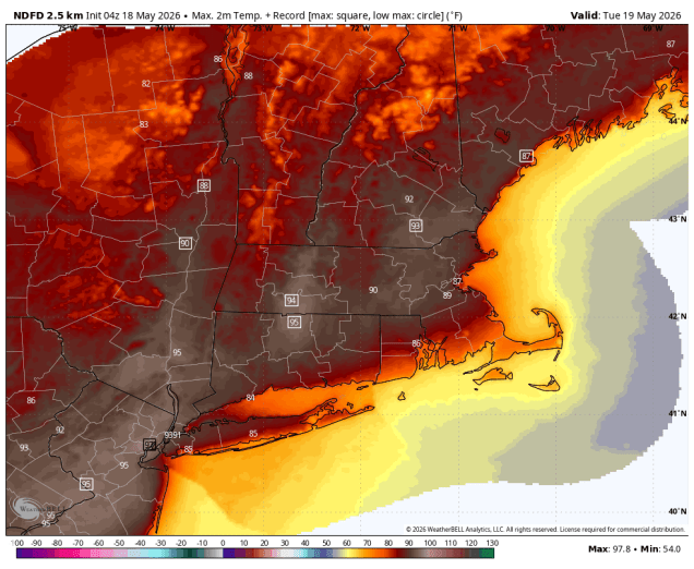
We’ve got an early taste of summer before we get to Memorial Day Weekend.
Some record highs are possible on Tuesday. Image provided by WeatherBell.
Before we get to the forecast, we wanted to point out that this is blog post #1000 since we started on this long, strange journey, and it is posted just two days shy of the 10th anniversary of the first blog post. Before that StormHQ was just a Facebook page and a Twitter account, but now it’s been 10 years or sarcasm, information, commentary and of course weather forecasts, and for those of you still reading, we thank you very much. Now, onto the forecast.
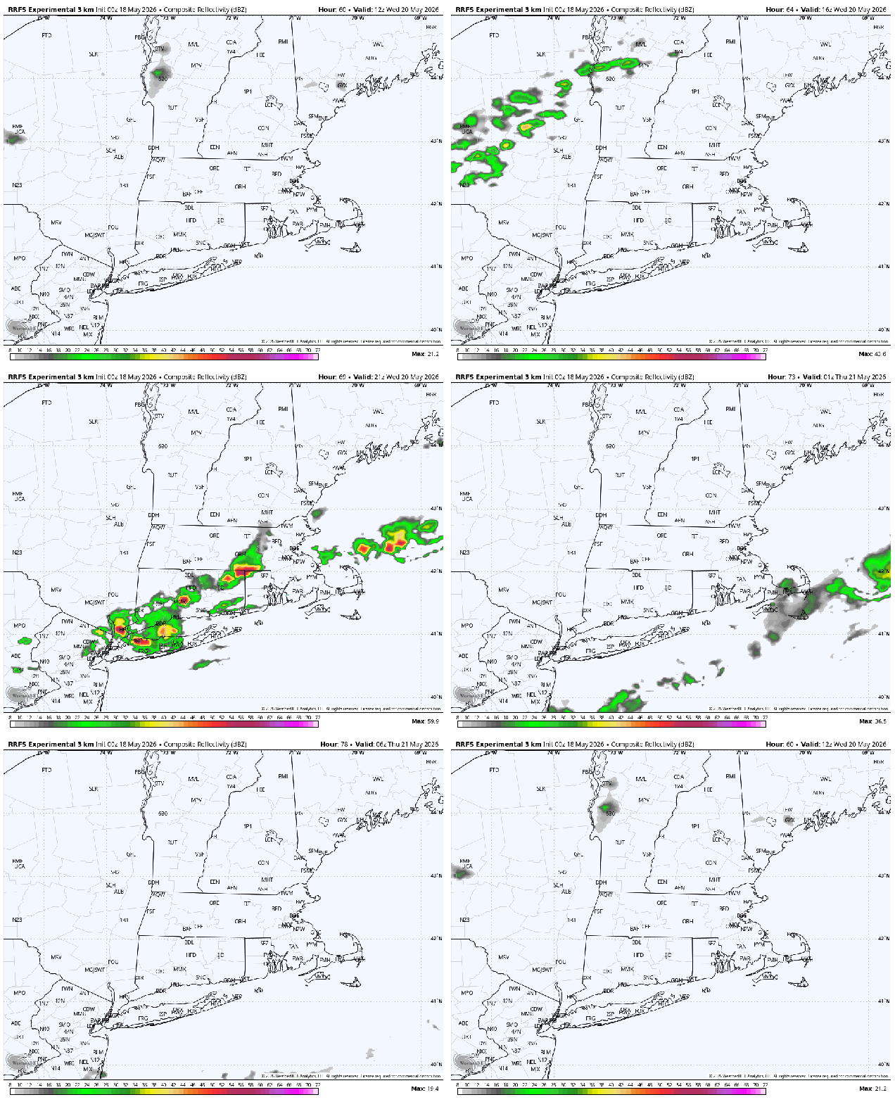
A backdoor cold front has settled south of the region, so temperatures are will be on the cooler side today despite plenty of sunshine. Of course, cool is relative, as temperatures will be close to where the should be in mid-to-late May, but most places will be 10-20 degrees cooler than they were on Sunday. That front will lift back northward tonight, allowing the warm to hot and increasingly humid weather to return on Tuesday, with temperatures away from the South Coast getting well into the 80s, with some spots topping 90 degrees. We could see a few showers and thunderstorms during the afternoon, but the bulk of the region should remain dry. Wednesday starts off with sunshine, but clouds will quickly move in as a cold front heads our way. It will be another very warm and humid day with temperatures well into the 80s away from the South Coast, with a few places possibly reaching 90 again. The front will trigger showers and thunderstorms during the afternoon and evening, some of which could be strong to severe. Some of the stronger storms may produce heavy downpours, gusty winds, and hail. High pressure builds in behind the front with cooler and drier conditions for Thursday and Friday.
A cold front may be accompanied by a line of thunderstorms Wednesday afternoon and evening. Loop provided by WeatherBell
As for Memorial Day Weekend, there is a considerable amount of uncertainty at this point. We’ll have high pressure to the north, keeping temperatures on the cooler side, which a series of waves ride along a frontal system south of the region. That’s about all the models agree on at this point. Whether there is one wave or two, when do they move through, how far north does the rain get, how cool will it stay with cloudcover and/or rainfall. None of these are questions we can answer with any certainty at this point. Right now, it looks like Saturday and possibly Sunday will be the cooler and wetter days, but this is far from certain, and doesn’t mean that Monday will be a great day either for the holiday. We should have a better idea by the time we get to our Weekend Outlook on Thursday, and will take a deeper dive into it at that point.
Will Saturday be wet? The models don’t agree. Images provided by Pivotal Weather.
Monday: Partly to mostly sunny. High 75-82 south and west of Boston, 67-74 north of Boston, possibly a little cooler across the North Shore and Hew Hampshire Seacoast.
Monday night: Clear to partly cloudy. Low 58-65, except 50-57 across the North Shore, Hew Hampshire Seacoast, and Cape Cod.
Tuesday: Sunshine and some afternoon clouds, breezy, chance for an afternoon shower or thunderstorm. High 87-94, except 79-86 across the South Coast and 71-78 across Cape Cod.
Tuesday night: Partly cloudy. Low 64-71, cooler across Cape Cod.
Wednesday: Morning sun then increasing clouds with late-day showers and thunderstorms, some could be strong, breezy. High 84-91, except 76-83 across the South Coast and 68-75 across Cape Cod.
Wednesday night: Showers and storms end in the evening, becoming partly cloudy. Low 48-55.
Thursday: Partly sunny, much cooler. High 63-70.
Thursday night: Partly cloudy. Low 42-49.
Friday: Partly sunny. High 61-68.
Saturday: Mostly cloudy with a chance of showers. High 59-66.
Sunday: Mostly cloudy with a chance of showers. High 61-68.
Memorial Day: Intervals of clouds and sun. High 64-71.
Once again, most of this week will be fair quiet weather-wise. The tropics, however, are not going to be quiet.
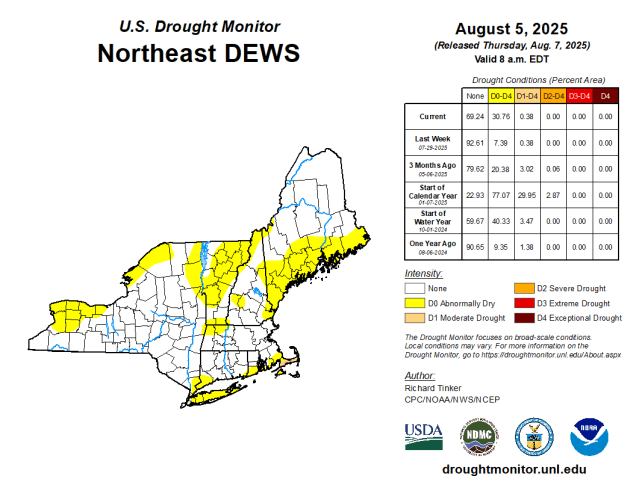
Drought conditions are beginning to re-emerge, especially in SE Massachusetts and Cape Cod. Image produce by the National Drought Mitigation Center.
High pressure remains in control for the first half of the week with warm and increasingly humid conditions. While the humidity levels will be on the rise, it won’t be oppressive, certainly not like it was earlier in the summer. Temperatures will likely be near or over 90 degrees for the next few days inland, but a seabreeze will keep coastal areas cooler each afternoon. We could see a shower or thunderstorm across inland areas Wednesday, but otherwise, it should remain dry. A cold front will move in on Thursday, likely producing some showers and thunderstorms, along with some cooler weather. Temperatures on Thursday will be dependent on the timing of the front and the associated thunderstorms. A later arriving front likely means another day of 90-degress temperatures inland, but and earlier-arriving front would prevent that. High pressure builds back in with drier and cooler conditions on Friday. As the high slides off to the east, warmer weather will return for the weekend.
Tuesday looks like the hottest day with temperatures well into the 90s away from the coast. Image provided by Weathermodels.com
Now we’ll talk about the tropics. As you may have seen from all the Facebook Forecasters out there, Major Hurricane Erin is going to wipe out the East Coast in about 10 days. Well, that’s what a few of the models have shown at times over the past several days, and since the models show it, that’s what’s going to happen, because the models are always spot on 10 or more days in advance, right? Now, we’ll give you some real data. There is a strong tropical wave that moved off the west coast of Africa a few days ago. It has been fighting off some dry air and is over water that isn’t quite warm enough to sustain a tropical system, but it has shown some signs of organization in the past day or so. In fact, by the time some of you read this the National Hurricane Center may have already declared the system Tropical Depression 5. It will pass close to or over the Cabo Verde Islands today and then head in a general westward direction, likely strengthening as it does. The strengthening should be slow and steady as the system spending the next 5 day or so over the open waters of the Atlantic, and it will probably get upgraded to Tropical Storm Erin over the next day or two. It could become a hurricane later this week or next weekend. At that point, it should be approaching the longitude roughly near the Lesser Antilles. Most (but not all) of the models show the system passing north of the Islands, but that does not mean they are safe yet. However, around that point is an important spot to watch what the storm is doing. Some models show it turning more toward the northwest or even north at that point and heading out to sea (though possibly threatening Bermuda), while other models show it continuing off toward the west-northwest or even west. This would increase the threat to the Bahamas (and possibly the Greater Antilles). Of course, this is all still a week away, at which point the average error in the models is several hundred miles, so this really is just pure speculation. We won’t even get into how strong it might be, as intensity forecasts in the models are notoriously poor. For now, we’ll just say that it’s something to keep an eye on, but don’t worry about yet. *IF* it were to become a threat to the East Coast (and that’s a very big IF), we’ll give you plenty of advance notice. We’re not here for hype or page clicks (like the Facebook Forecasters), we’re here to give you a true look at what’s going on. We’ll likely be writing special blogs about this system (and the rest of the tropics) at various times this week. For now, ignore the noise, and listen to a trusted source, not one that picks out the scariest looking forecast model for 10 days from now and insists that is exactly what is going to happen (because it almost certainly won’t).
There’s still a wide range in model solutions for where the tropical system will track over the next 7 days. Image provided by Tomer Burg.
Monday: Sunshine and a few clouds. High 88-95, a little cooler along the coast.
Monday night: Clear skies. Low 65-72.
Tuesday: Plenty of sunshine. High 90-97, cooler along the coast.
Tuesday night: Clear to partly cloudy. Low 65-72.
Wednesday: Sunshine gives way to increasing afternoon clouds, chance for a late-day shower or thunderstorm, humid. High 86-93, cooler along the coast.
Wednesday night: Partly to mostly cloudy. Low 67-74.
Thursday: Partly sunny, showers and thunderstorms possible in the afternoon. High 83-90, cooler across the South Coast and Cape Cod.
Thursday night: Becoming clear. Low 62-69.
Friday: Sunny, drier. High 78-85, coolest near the coast.
Saturday: More sunshine. High 81-88, a little cooler along the coast.
Sunday: Mostly sunny. High 86-93, cooler along the coast.
Remember how it rained nearly every weekend through the Spring? That won’t be the case this weekend.
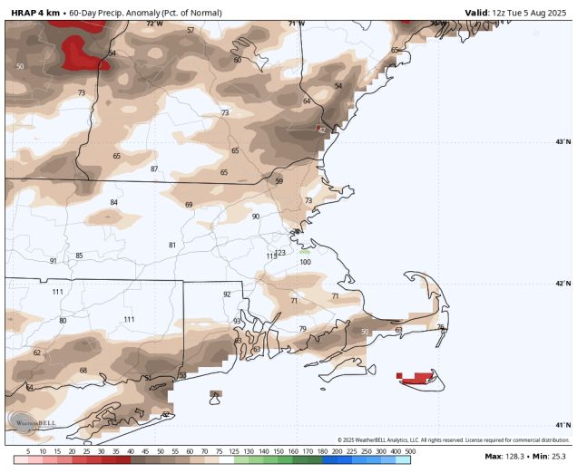
It’s been quite dry across much of the area since June 1. Image provided by WeatherBell.
High pressure will dominate our weather right through the weekend. The high, currently centered over southeastern Canada will slowly drop southward, settling off the East Coast this weekend. Not only will we stay dry through this time, but temperatures will trend upward, and by the end of the weekend, so will humidity levels. The smoke and haze that has plagued us for the past few days from Canadian wildfires will thin out and drift away, so we’ll have sunshine for most of the time as well (during the daylight hours).
Monday is looking like a hot and humid day across the region. Image provided by weathermodels.com
Wednesday night: Partly to mostly cloudy with some patchy fog in spots. Low 57-64.
Thursday: A cloudy start, gradually becoming partly to mostly sunny. High 75-82.
Thursday night: Clear skies. Low 54-61.
Friday: Mostly sunny. High 78-85, a little cooler along the coast.
Friday night: Clear skies. Low 55-62.
Saturday: Plenty of sunshine. High 79-86, a little cooler along the coast.
Saturday night: Clear skies. Low 58-65.
Sunday: Sunshine and a few afternoon clouds, a little more humid. High 85-92, a little cooler along the coast.
Sunday night: Clear to partly cloudy. Low 62-69.
Monday: Mostly sunny, humid. High 88-95, a little cooler along the coast.
Heat and humidity return for the first half of the week, but the latter half will tell a different story.
Heat Advisories are in effect for the first half of the week. Image provided by the National Weather Service office in Norton, MA.
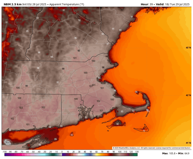
We start the week off with high pressure moving offshore, resulting in hot and humid conditions into Wednesday. Tuesday looks the be the hottest day of this stretch, with temperatures well into the 90s, and only a stray shower or thunderstorm providing minimal relief. Wednesday could also be quite hot, but we’ll have a cold front moving in, with clouds and a few showers and thunderstorms ahead of it during the afternoon. The front moves through and then stalls out near or just off the South Coast, which is where things get tricky.
It will feel like it is near or over 100 degrees Tuesday afternoon. Image provided by WeatherBell.
A wave of low pressure will ride along that front, bringing some rain and cooler air into the region. What’s uncertain is where the front stalls out, and the timing of the wave. For now, it looks like the bulk of the rain will be South of the Mass Pike, but that is highly uncertain. The rain could get all the way into southern New Hampshire, or it could be confined to the South Coast. This will be dependent om where the front actually is. How much rain will be dependent on how strong the wave is. Some models have light to moderate rain in spots, some show the potential for some hefty amounts. The other question is the timing. Some models show most of the rain Thursday and Thursday night, some have the heavier rain Thursday night into Friday, some even have it linger into Friday night. What you’ll see below is our best estimate on all these variables at this time, but it is obviously very low confidence. Behind the system high pressure builds in with cooler and drier weather for the weekend.
There’s a lot of uncertainty with the rainfall potential for the end of the week. Images provided by Pivotal Weather.
Monday: Patchy morning fog, otherwise mostly sunny, hot, and humid. High 85-92, cooler along the coast.
Monday night: Clear skies, a little patchy fog again. Low 65-72.
Tuesday: Sunshine and a few clouds, slight chance for an afternoon shower or thunderstorm. High 90-97, cooler across Cape Cod.
Tuesday night: Clear to partly cloudy. Low 66-73.
Wednesday: A mix of sun and clouds, chance for some late-day showers and thunderstorms. High 88-95, cooler across Cape Cod.
Wednesday night: Partly to mostly cloudy, showers and thunderstorms possible. Low 65-72.
Thursday: More clouds than sun with showers and thunderstorms likely. High 75-82.
Thursday night: Partly to mostly cloudy with more showers and thunderstorms. Low 58-65.
Friday: Showers and thunderstorms ending, becoming partly sunny. High 70-77.
Lots of changes coming up this weekend, but the humidity will probably hang around.
It will feel like it is near or over 100 degrees Friday afternoon. Image provided by WeatherBell.
High pressure settles offshore, keeping us on the warm and humid side. In fact, Friday will be downright hot with many places away from the South Coast getting into the 90s. When you factor the humidity it, it may feel like it is close to or a little over 100 in the afternoon. However, we’ll also see clouds moving in ahead of a cold front. That front will trigger some showers and thunderstorms during the afternoon and evening. We’re not expecting widespread severe weather, but some of the storms could produce gusty winds and heavy downpours. The front settles offshore before stalling out, with somewhat cooler and drier air moving in for Saturday. By somewhat, we mean temperatures in the 80s instead of 90s, and dewpoints in the upper 50s and lower 60s instead of upper 60s and lower 70s. So, it’ll be a typical summer day across the region. Sunday may not be as nice. A wave of low pressure will ride along the front and bring the humidity back in, along with the possibility some showers and thunderstorms, mostly during the afternoon and evening. However, some models keep the showers offshore, so we may end up with a decent day. High pressure returns for Monday with sunshine, warmer temperatures, and moderate humidity levels.
Will Sunday be wet or dry? It depends on which model you trust. Images provided by Pivotal Weather.
Thursday night: Clear skies. Low 66-73.
Friday: Some morning sun, then clouds move in with some showers and thunderstorms likely during the afternoon. High 88-95, cooler across the South Coast and Cape Cod.
Friday night: Showers and thunderstorms ending in the evening, becoming clear to partly cloudy after midnight. Low 63-70.
Saturday: A mix of sun and clouds. High 80-87, a little cooler near the coast.
Saturday night: Becoming partly to mostly cloudy. Low 60-67.
Sunday: More clouds than sunshine, showers and thunderstorms may develop in the afternoon. High 75-82.
Sunday night: Cloudy with any showers and thunderstorms ending during the evening, becoming partly cloudy late at night. Low 62-69.
Monday: Becoming mostly sunny. High 84-91, cooler across the South Coast and Cape Cod.
Humidity remains in place for several more days this week, but the heat will also make a comeback.
Dewpoints will get well into the 70s by midweek. Image provided by weathermodels.com
High pressure remains off to our southeast today, with a trough of low pressure moving toward the region. The result will be southwest winds bringing very warm and humid air into the region. As the trough gets nearer, we’ll see some showers and thunderstorms moving in late in the day and into the evening hours. While there could be a few strong storms, the timing will likely be a little too late in the day for any widespread severe weather. However, any storms that do form will likely be fairly slow-moving, so they could dump a lot of rain in localized areas, which could result in some flash flooding in spots. Now this won’t be like what we’ve see in Texas recently, and it probably won’t be as bad as we say south of Boston this past Thursday morning, but it’s something to keep in mind if you’ll be out and about this evening.
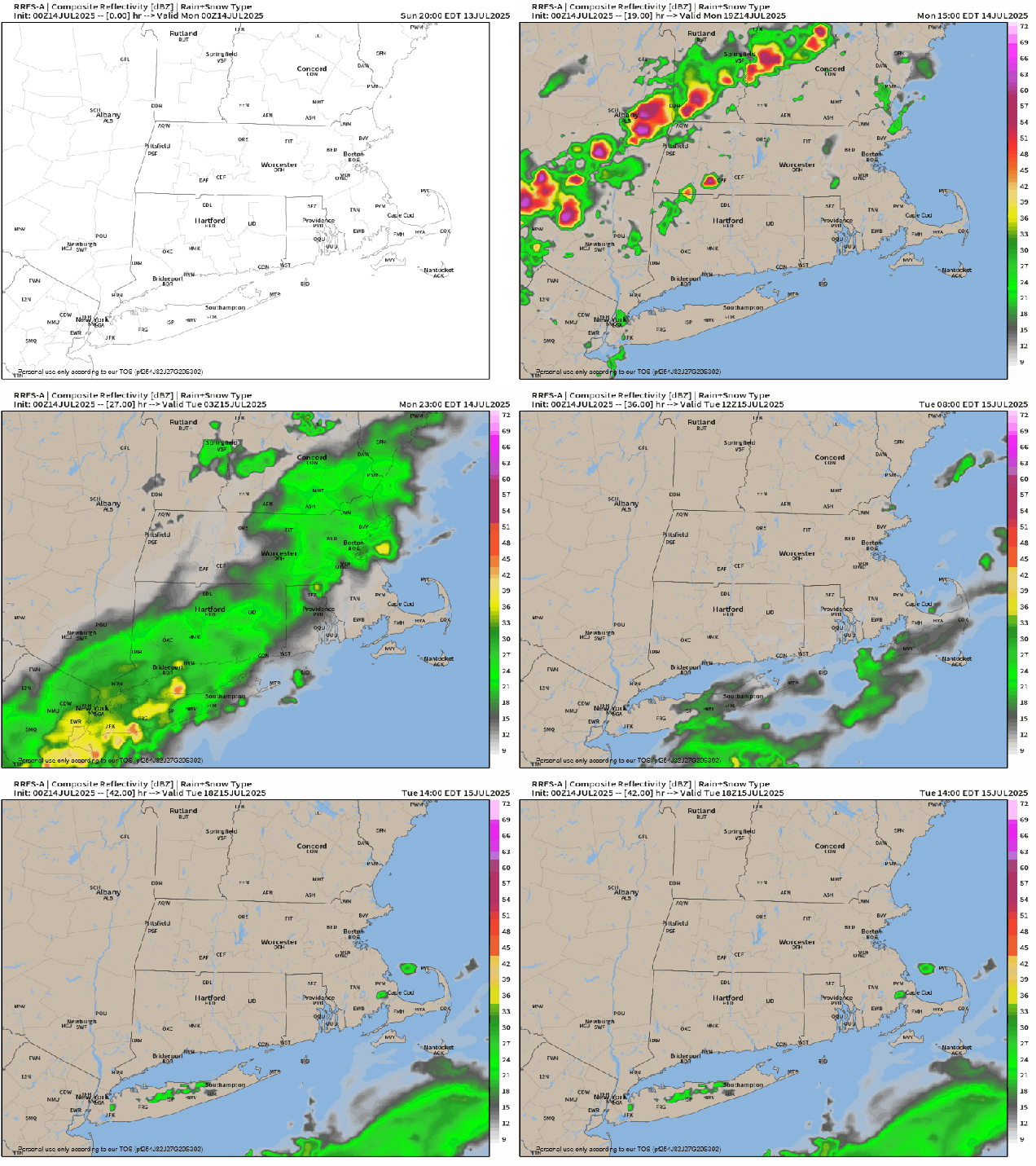
Thunderstorms may cross the region late this afternoon and evening. Loop provided by weathermodels.com
Some of the showers could linger into Tuesday morning across parts of eastern and southeastern Massachusetts until the trough moves offshore, but once it does, humidity levels won’t drop much, if at all, and we set the stage for some hot weather to return. Once the sun breaks out on Tuesday, temperatures should get well into the 80s, with dewpoints in the 60s, resulting in a heat index likely reaching the lower 90s in many spots in the afternoon. The heat and humidity really return for Wednesday and Thursday, with many locations getting near or above 90 degrees, but with dewpoints creeping up even higher, the heat index may approach or exceed 100 each afternoon. A couple of widely scattered showers and thunderstorms may provide a little relief on Wednesday, with coverage or showers and storms expanding a bit more on Thursday. Again, some of these storms could be slow-moving, so localized flash flooding is possible.
The heat index will get well into the 90s Wednesday afternoon. Image provided by WeatherBell.
Friday is the day with the biggest question marks at this point. A cold front will be heading towards the region, with very warm and very humid air remaining in place ahead of it. The question is – how warm? Some models give us enough sunshine to allow temperatures to get near or above 90 once again, others have enough cloudcover to keep us in the 80s. As the front moves in, showers and thunderstorms are likely. The timing of the front and the amount of sunshine we get will help determine whether we can expect any severe weather or not. High pressure builds in with cooler and drier weather for Saturday. Another system could start to move in by later Sunday, but it also could hold off until Sunday night or Monday. We’ll have a better idea of what to expect from that when we get to our Weekend Outlook, which will be published on Wednesday this week instead of Thursday.
Will Sunday be wet or stay dry? It’s too early to tell. Images provided by Pivotal Weather.
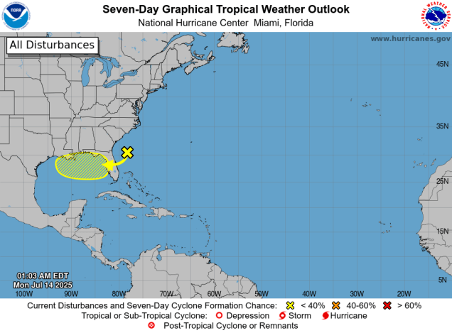
We’re also keeping an eye on the tropics. An area of disturbed weather currently off the Southeast coast is expected to drift towards northern Florida over the next few days, bringing some heavy rain to parts of the Sunshine State. After that, it should continue westward and into the northeastern Gulf. Some models show the potential for the system to develop as it moves westward across the northern Gulf, others don’t do much with it. Water temperatures are plenty warm, so that won’t be a factor. This is something we’ll be keeping an eye on over the next several days.
There is a chance a system could develop in the northern Gulf later this week. Image provided by the National Hurricane Center.
Monday: Some low clouds and fog early, then becoming partly sunny, humid, showers and thunderstorms possible late in the day. High 80-87, a little cooler across the South Coast and Cape Cod.
Monday night: Any lingering showers or storms end in the evening, remaining partly to mostly cloudy with another shower or two and some patchy fog possible. Low 66-73.
Tuesday: Morning clouds, maybe a shower or two across southeastern Massachusetts, then becoming partly to mostly sunny, still humid. High 83-90, a little cooler across the South Coast and Cape Cod.
Tuesday night: Partly cloudy. Low 65-72.
Wednesday: A mix of sun and clouds, very humid, slight chance for a pop-up shower or thunderstorm during the afternoon. High 86-93, cooler across the South Coast and Cape Cod.
Wednesday night: Partly to mostly cloudy and muggy with some patchy fog. Low 68-75.
Thursday: Partly sunny and quite humid, some afternoon and evening showers and thunderstorms possible, breezy in the afternoon. High 84-91, a little cooler across the South Coast and Cape Cod.
Thursday night: Partly cloudy, muggy. Low 69-76.
Friday: Partly sunny and humid with showers and thunderstorms developing in the afternoon, ending in the evening. High 86-93.
Saturday: A mix of sun and clouds, not as humid. High 78-85.
Sunday: Intervals of clouds and sun, chance for late-day showers and thunderstorms. High 79-86.
Heat and humidity remain in place to start the week, but they won’t last too long.
The heat index will be in the lower to middle 90s again this afternoon. Image provided by WeatherBell.
High pressure sits offshore today while a cold front begins to approach from the west. That’s a recipe for hot and humid conditions across our region today. We could see a few showers and thunderstorms pop up during the afternoon, but they should not be widespread. Tuesday is the transition day, though it will be very warm to hot and quite humid once again. Across parts of southeastern Massachusetts and Cape Cod there is the potential for some heavy downpours early in the day as what’s left of Tropical Storm Chantal moves past the area. Later, that cold front will move across the region, resulting in more widespread showers and thunderstorms, a few of which could be strong to severe across the interior.
A few showers and storms are possible today, but they are more likely late Tuesday into Tuesday evening. Loop provided by Weathermodels.com
The front settles south of the region, but likely remains close enough for plenty of clouds on Wednesday with cooler temperatures and possibly a few showers as well. A wave of low pressure riding along the front brings in more showers for Thursday. For Friday, a few lingering showers are possible, but some drier air will start to move in as high pressure starts to build in across southeastern Canada. Saturday should be mostly dry, but with an upper level low pressure area moving through we’ll see some clouds and possibly a shower or two in the afternoon. High pressure should move offshore for Sunday with dry and warmer weather expected.
A few models show the potential for heavy rain near the South Coast Thursday, but many show nothing more than scattered showers. Images provided by Pivotal Weather.
Monday: Partly sunny, breezy, quite humid, chance for a few showers or thunderstorms. High 85-92, a little cooler across the South Coast and Cape Cod.
Monday night: Partly to mostly cloudy with areas of fog, some rain possible across southeastern Massachusetts and Cape Cod after midnight. Low 67-74.
Tuesday: A mix of sun and clouds, humid, showers and thunderstorms likely in the afternoon, a few could be strong. High 85-92, cooler across Cape Cod.
Tuesday night: Mostly cloudy, showers and storms taper off fog redevelops. Low 64-71.
Wednesday: Partly to mostly cloudy, a shower or two is possible, cooler. High 75-82.
Wednesday night: Plenty of clouds, some showers possible after midnight, mainly near the South Coast. Low 61-68.
Thursday: Mostly cloudy with scattered showers. High 74-81.
Thursday night: Cloudy with more showers. Low 60-67.
Friday: Mostly cloudy, a few more showers, mainly in the morning, some sunny breaks possible in the afternoon. High 72-79.
Saturday: Becoming partly sunny, slight chance for a pop-up shower. High 75-82.
Sunday: Intervals of clouds and sunshine. High 77-84.