We’re going to keep this very brief today, but give you a look into Labor Day.
Warm and humid conditions are likely today ahead of a cold front. That front will produce showers and thunderstorms. some of which may be strong to severe. Drier air settles in behind the front for Tuesday as high pressure builds in. What’s left of Ida may bring in some heavy rain for Wednesday into Thursday. High pressure returns for Friday into Sunday with cooler and drier conditions, but we’ll start to warm up again for Labor Day with some showers and thunderstorms possible.
The models all show some heavy rain with what’s left of Ida, but don’t agree on how much. Images provided by Pivotal Weather.
Monday: Partly sunny with showers and thunderstorms developing in the afternoon. High 80-87.
Monday night: Showers and storms end in the evening, then becoming partly cloudy. Low 62-69.
Tuesday: More clouds than sun, not as humid. High 79-86.
Tuesday night: Partly cloudy. Low 60-67.
Wednesday: Cloudy with showers developing late in the day, possibly becoming a steady and heavy rain at night. High 72-79.
Thursday: Rain gradually ending, some clearing is possible late in the day. High 66-73.
Friday: Partly to mostly sunny. High 69-76.
Saturday: A mix of sun and clouds. High 69-76.
Sunday: Partly sunny. High 71-78.
Labor Day: Partly sunny with showers and thunderstorms possible. High 72-79.
We’ll return to our more customary detailed look at things with the Weekend Outlook on Thursday, once we’re back from vacation (no, we weren’t chasing Ida in Louisiana).
Henri isn’t done with us yet, but once it finally pulls away, hot and humid weather will return.
What’s left of Henri will slowly make its way eastward across the region today. It will be a warm and humid day, with some break of sunshine possible, especially early on. Showers and thunderstorms will redevelop, and some of them may produce heavy downpours. As was the case a few days ago when the remains of Fred moved through, a couple of spin-up tornadoes aren’t out of the question. If any of these do form, they’ll be short-lived and fairly weak, but can cause damage in their immediate vicinity. As for the rainfall, the heaviest rain will likely fall from western New England across southern New Hampshire, just to the north of the track of the low. This is consistent with what we normally see with tropical systems up in this neck of the woods, with most of the rainfall to the left of the track. That was certainly the case yesterday, with little rainfall across eastern Massachusetts after the initial band went through in the morning.
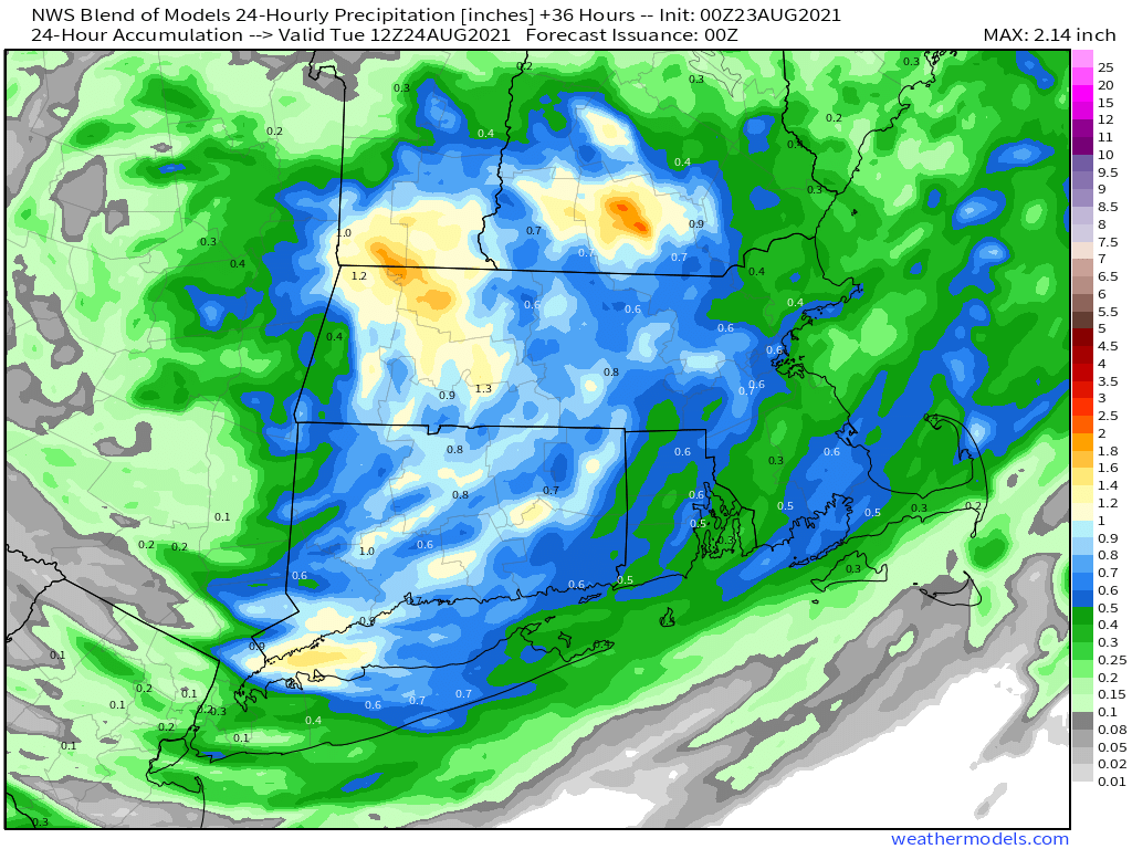
Some locally heavy rainfall is possible across the region today, especially from southern New Hampshire into western Massachusetts. Image provided by Weathermodels.com
Everything finally pulls away overnight, then high pressure builds in for Tuesday through Thursday with warm to hot and humid conditions. Temperatures will be well into the 80s each afternoon with some lower 90s possible. Dewpoints will also be in the upper 60s and 70s across the region, so it will feel quite oppressive. A cold front will bring an end to the heat and humidity late Thursday, but there is a chance that it may not come through until Friday, which would result in another warm to hot and humid day. High pressure builds in with cooler and drier conditions for Saturday. We may start to warm up again next Sunday as another warm front approaches the region.
Much more comfortable air should settle into the region next weekend. Image provided by WeatherBell.
Monday: More clouds than sunshine with some showers and thunderstorms likely, especially during the afternoon. High 77-84.
Monday night: Mostly cloudy with showers and storms ending, some clear may develop late at night. Low 65-72.
Tuesday: Becoming partly to mostly sunny and humid. High 81-88.
Tuesday night: Clear to partly cloudy. Low 65-72.
Wednesday: Sunshine and some afternoon clouds, humid. High 83-90.
Thursday: A mix of sun and clouds, humid, with showers and thunderstorms possible during the afternoon and evening. High 85-92.
Friday: Partly sunny, a few showers and thunderstorms are possible. High 79-86.
Saturday: Intervals of clouds and sun, much cooler. High 70-77.
We’ve got a nice start to the week with seasonably warm temperatures and low humidity, but changes are coming once again.
After the heat and humidity of last week, much more comfortable air settled in late Saturday, and it will remain in place Tuesday thanks to a large high pressure area. However, as that high slides offshore later on Tuesday southwest winds will start to send humidity levels rising again, but that’s just a taste of what is coming.
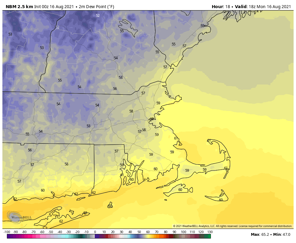
Dewpoints will be in the 50s and lower 60s this afternoon. Image provided by WeatherBell.
Much of the remainder of the week looks warm (but not hot) and quite humid, but also unsettled. High pressure will remain anchored offshore, pumping the humid air into the region. Although it will be warm, it won’t be hot, because we’ll actually have plenty of cloudcover at times, along with a daily chance for showers and thunderstorms. Eventually some of the moisture from Fred (more on the tropics down below) should get in here, enhancing the rainfall. We’re not quite going back to our record-breaking wet pattern from July, but some parts of the region could pick up a decent amount of rain during the latter half of the week. The day with the most uncertainty is Sunday, which could end up drier and cooler if a cold front drops southward across the region.
Some of the models show a decent amount of rain between now and Saturday. Images provided by Pivotal Weather.
As for the tropics, there are now three systems in the Atlantic that we’re watching. Tropical Storm Fred is expected to make landfall in the Florida Panhandle late tonight or early Tuesday as a strong tropical storm, though it wouldn’t be a surprise if it somehow became a hurricane before landfall. It should rapidly weaken once inland. Tropical Depression Grace is expected to remain weak as it passes close to or over Hispaniola and Cuba over the next few days, assuming it even survives the trip. If it does, it could start to strengthen as it gets into the Gulf of Mexico later this week. Finally, we have Tropical Depression Eight, which formed near Bermuda late Sunday night. It will bring some squally conditions to Bermuda over the next day or two, and should gradually strengthen, but right now, doesn’t look like it’ll impact any other land areas. We’ll have a much more detailed look at the tropics later today in another blog post.
There are three tropical systems to keep an eye on in the Atlantic. Image provided by the Canadian Hurricane Centre.
Monday: Sunshine and some high clouds. High 75-82.
Monday night: Partly cloudy. Low 57-64.
Tuesday: Partly sunny. High 78-85.
Tuesday night: Partly to mostly cloudy. Low 64-71.
Wednesday: Plenty of clouds with a few showers or thunderstorms possible. High 77-84.
Thursday: Mostly cloudy with scattered showers and thunderstorms. High 77-84.
Friday: Clouds and some sunny breaks with more showers and thunderstorms possible. High 76-83.
Saturday: Intervals of clouds and sunshine, with a few showers or thunderstorms around. High 78-85.
Sunday: Partly sunny, chance for more showers and thunderstorms. High 76-83.
Finally, we’ll leave you with this thought. In Montana, temperatures are likely going to top 100 across central and eastern parts of the state today, and again tomorrow. Then a strong cold front is going cross the region later Tuesday and Wednesday. Behind that front, temperatures will be 40-50 degrees cooler than the day before. Oh, but the temperature drop isn’t the only concern. Take Helena, MT for example. The GFS has a forecast high of 96 in Helena today. Tomorrow night, that same model is forecasting a low of 34, accompanied by 5″ of snow.
For the first time in a while, we’ve fairly typical summertime weather coming for a large chunk of the upcoming week.
We’ve got a frontal system south of the region today and a wave of low pressure will ride along it, bringing in some showers and cooler than normal temperatures. However, that front will lift northward as a warm front on Tuesday, allowing warm and humid air to move back in for Tuesday. That’s just the appetizer before the main course.
Temperatures will be several degrees below normal across the region today. Image provided by Weathermodels.com
For Wednesday through Friday, we’ll have a Bermuda high sitting offshore, pumping hot and humid weather into the area. Temperatures will get into the 90s across a large portion of the region, with heat indices possibly approaching 100 in many locations. It’ll be a great time to head to the beach, out to the pool, or to sit in the air conditioning. We will have some showers and thunderstorms popping up each afternoon, which will take the edge off the heat in some areas. Any storms that do form could produce some heavy downpours, but widespread severe weather isn’t likely at this time.
The heat index could approach 100 Wednesday and Thursday afternoon. Image provided by WeatherBell.
A cold front will move through on Saturday, bringing an end to the heat. Some showers and thunderstorms may accompany the front, but the timing is still in question. This will have implications for not only temperatures during the day, but whether there is a threat for severe weather or not. High pressure builds in behind the front on Sunday with cooler and drier conditions.
Finally, we’re going to take a look at the tropics, as the Atlantic is showing signs of waking up. There are two areas in the Atlantic that are being monitored right now. The first is a few hundred miles east of the Leeward Islands. This system could get better organized over the next few days and become a tropical depression. It will cross the Leeward Islands later today before heading towards Puerto Rico and the Virgin Islands. Whether it develops or not, a period of heavy rain and gusty winds is likely from the Lesser Antilles into Puerto Rico Monday into Tuesday. Another tropical wave is located a few hundred miles east of the first disturbance. This one is less organized at the moment, but could develop as it continues westward as well. We’ll keep an eye on both of these, and if anything develops, we’ll likely have a special blog post about it.
The Atlantic is starting to wake up. Image provided by the National Hurricane Center.
We’re getting into the time of year that we need to start paying attention to the tropics around here. While the storms well out in the Atlantic give us plenty of advance notice that they’re heading this way, it’s the ones like Bob that we really have to worry about in August and September. Bob formed as a tropical depression near the Bahamas on Friday August 16, 1991 and made landfall on the south coast of Rhode Island as a Category 2 Hurricane on Monday afternoon August 19. That’s not a lot of time to prepare for a hurricane.
Storms can form in the Bahamas at this time of year and give us little time to prepare for them. Image provided by the National Hurricane Center.
Monday: Patchy fog early, otherwise more clouds than sunshine, chance for a few showers, favoring the South Coast. High 74-81.
Monday night: Partly to mostly cloudy, some drizzle or fog is likely. Low 62-69.
Tuesday: Partly sunny, slight chance for a late-day shower or thunderstorm, mainly well north and west of Boston. High 78-85.
Tuesday night: Partly cloudy. Low 65-72.
Wednesday: A mix of sun and clouds, chance for a late-day shower or thunderstorm, humid. High 86-93.
Thursday: Partly sunny, breezy, and humid with a few showers and thunderstorms during the afternoon and evening. High 87-94.
Friday: Partly to mostly sunny, chance for a few showers and thunderstorms late in the day, humid. High 86-93.
Saturday: Intervals of clouds and sun with scattered showers and thunderstorms likely. High 80-87.
As we get into the first week of August, we’ll leave the wet pattern of July behind, though parts of the region could still see a decent amount of rain during the next 7 days.
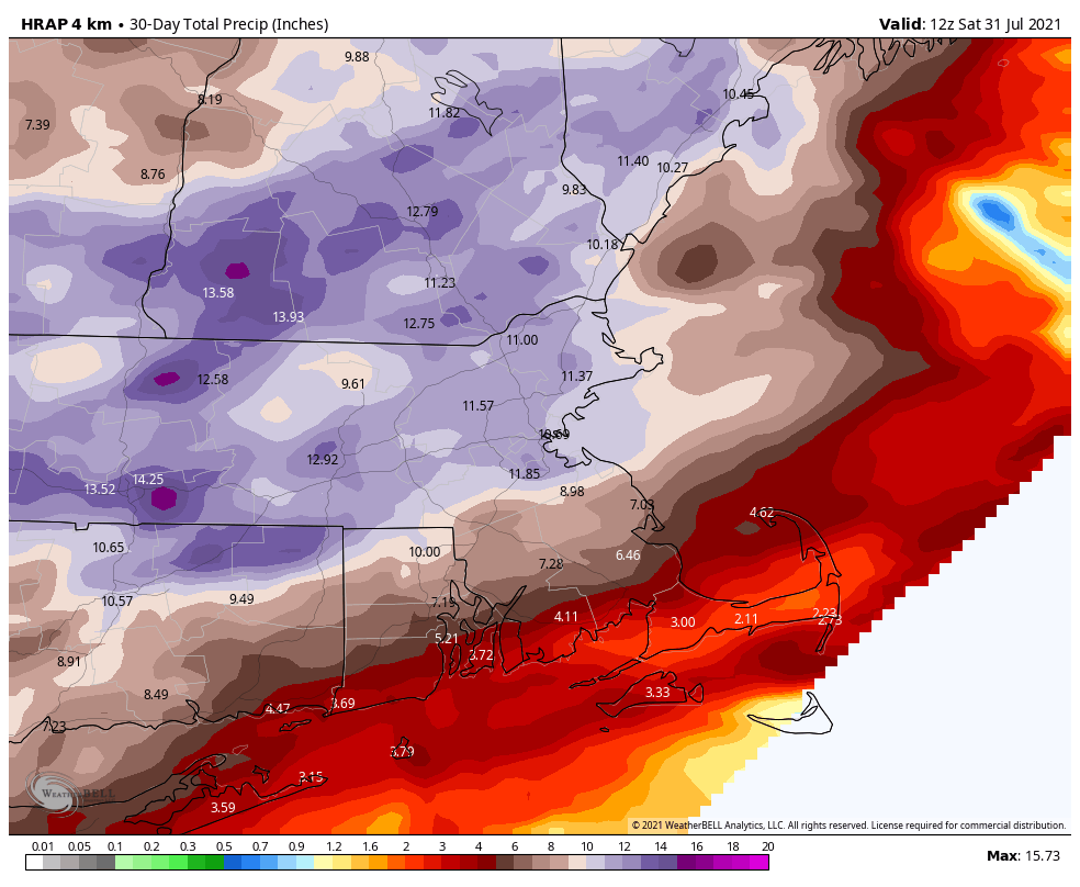
Much of the region received more than 10 inches of rain in July. Image provided by WeatherBell.
Low pressure pulls away from the region this morning, with any lingering showers coming to an end. However, an upper-level disturbance will move through this afternoon, possibly triggering another shower or two. High pressure then builds in for Tuesday with dry and seasonable conditions.
Wednesday is a little bit of a question mark for part of the area. High pressure will remain in control resulting in a dry day for most of us. However, the front that moved through this morning will stall out offshore, and a wave of low pressure will ride up along it on Wednesday. This may bring in some showers to parts of Cape Cod and possibly southeastern Massachusetts and southern Rhode Island. Some of the models show the potential for some heavy rain in these areas, but this will be dependent on how close the wave actually gets to us.
Most of the models don’t bring Wednesday’s rain beyond southeastern Mass. Images provided by Pivotal Weather.
Another system follows for late Thursday into early Friday, but again, any rain may be limited to southeastern Massachusetts and Cape Cod, depending on how close the system passes offshore. Another system may move through next weekend with more showers possible, but temperatures will start to warm up once again as a ridge of high pressure over the Atlantic starts to strengthen.
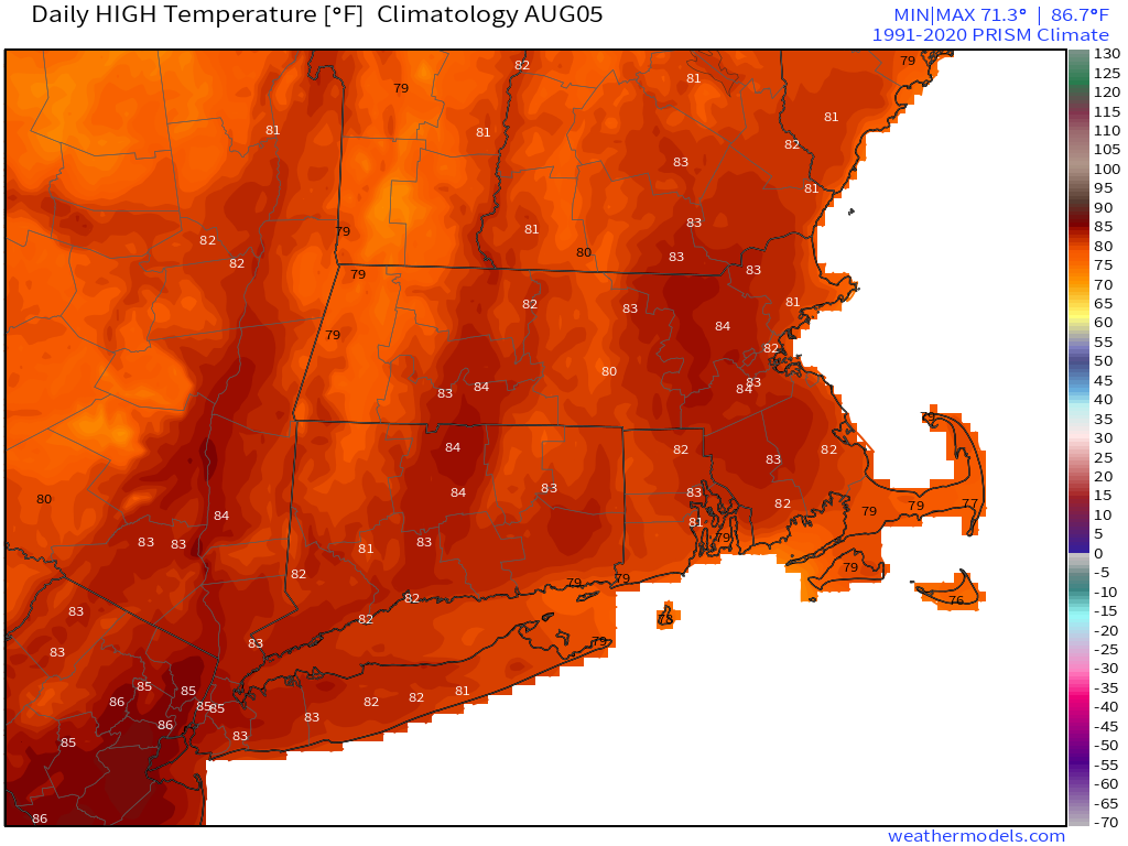
Average high temperatures in early August should be in the lower to middle 80s across the region. Image provided by Weathermodels.com
Monday: Showers end early, then becoming partly sunny with a slight chance for another shower during the afternoon. High 74-81.
Monday night: Clear skies. Low 55-62.
Tuesday: A mix of sun and clouds. High 74-81.
Tuesday night: Partly to mostly cloudy. Low 57-64.
Wednesday: Partly to mostly cloudy, showers possible across southeastern Massachusetts and Cape Cod. High 74-81, a cooler along the coast.
Thursday: Plenty of clouds with some sunny breaks, showers are possible late in the day and at night across southeastern Massachusetts and Cape Cod. High 73-80.
Friday: Partly to mostly sunny. High 77-84, cooler along the coast.
Saturday: Intervals of clouds and sun with a chance for showers. High 80-87.
Sunday: A mix of sun and clouds, a shower is possible. High 81-88.
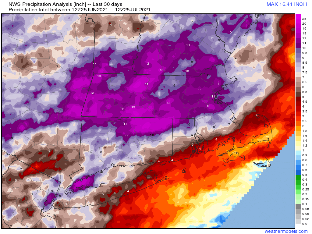
July has featured record or near-record rainfall across the region, but as it comes to a close, so does the very wet pattern we’ve been stuck in.
A large swath of the region has received over 10 inches of rain this month. Image provided by Weathermodels.com
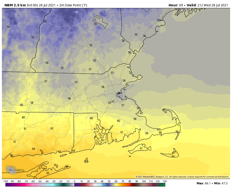
We start the week off with high pressure building in today, bringing us sunshine and warm temperatures, with a few places possibly getting to 90 this afternoon. Humidity levels will be fairly comfortable as drier air settles into the region. Our dry weather won’t last long as a cold front approaches on Tuesday, with some showers and thunderstorms accompanying it during the afternoon and evening. It’ll be quite warm ahead of the front again, with temperatures well into the 80s. Drier air settles back in on Wednesday along with cooler temperatures, but again, the dry air will be short-lived. Another frontal system approaches on Thursday with more showers and thunderstorms likely.
Dewpoints will only be in the 50s Wednesday afternoon. Image provided by WeatherBell.
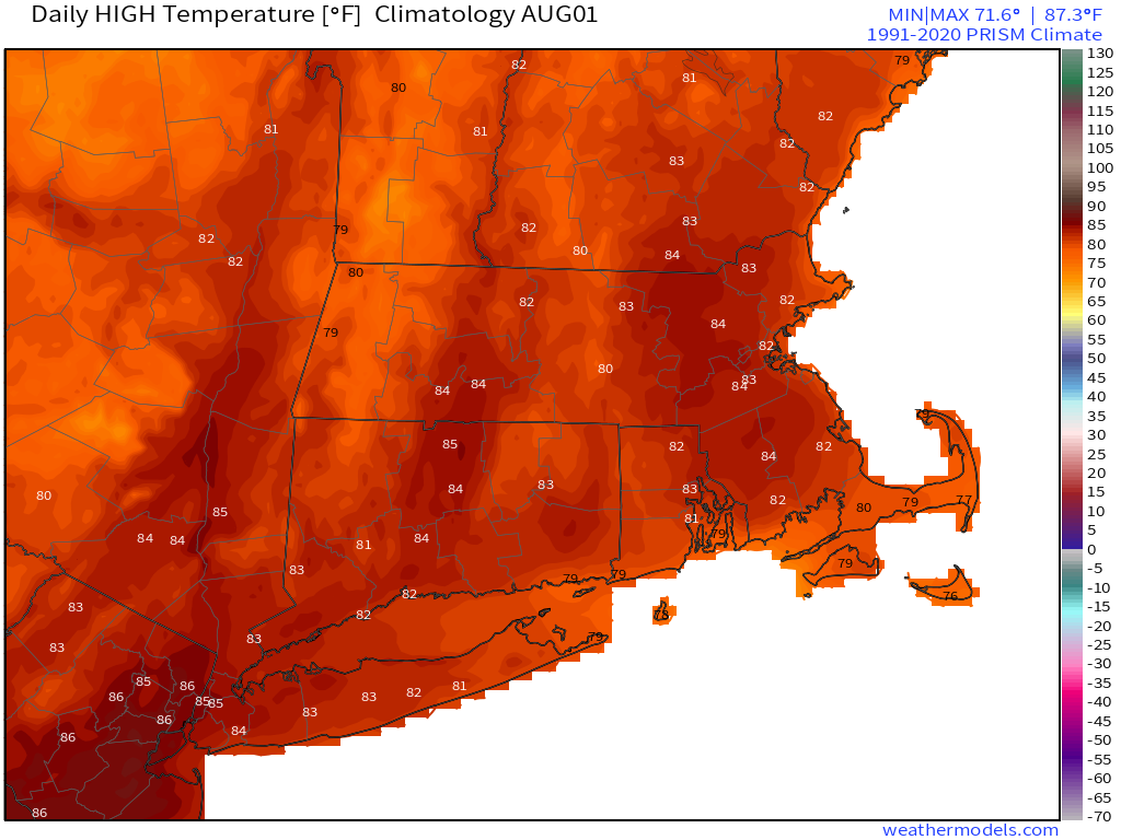
By Friday, we’ll have an upper-level trough settling into the Northeast, which means that we could see a few showers popping up during the afternoon. High pressure builds in on Saturday with cool and dry conditions. Yet another frontal system approaches on Sunday, with another round of showers and thunderstorms possible.
At the start of August, average high temperatures should be in the lower to middle 80s around here. Image provided by Weathermodels.com
Monday: Sunshine and some afternoon clouds. High 82-89.
Monday night: Clear skies. Low 61-68.
Tuesday: Increasing clouds, showers and thunderstorms likely late in the day. High 82-89.
Tuesday night: Showers and storms end in the evening, then becoming partly cloudy. Low 58-65.
Wednesday: A mix of sun and clouds, cooler. High 72-79.
Thursday: More clouds than sun with showers and thunderstorms possible late in the day and at night, breezy. High 71-78.
Friday: Partly sunny and breezy, slight chance for a shower. High 74-81.
Saturday: Partly to mostly sunny. High 71-78.
Sunday: A mix of sun and clouds, breezy, showers and thunderstorms possible late in the day. High 76-83.
Finally, we’ll leave you with this uplifting thought from the good folks at the National Weather Service office in Caribou, ME:
149 days till the winter solstice, but only 95 days till the average date of the first measurable snowfall, and 82 days to the first date of snow flurries (non measurable snow) in Caribou, Maine. #MEwx
We’ve got good news and bad news this week. The good news is that we will have a few dry days this week. The bad news is that there’s more rain on the way.
An upper-level disturbance will cross the region today, which means more clouds and more showers, though the day shouldn’t be a washout. Rainfall totals should be on the light side, which will be a welcome change from the weekend. The cloud cover will keep temperatures on the cool side during the daytime. High pressure then builds in for Tuesday with warmer and more humid conditions. It’s tempting to say that we’ll have a dry day, but it wouldn’t surprise us if a few showers and thunderstorms developed in the afternoon or evening, especially well north and west of Boston. By Wednesday, we’ll have a better chance for showers and storms as a cold front approaches the region. In fact, some of the storms that do develop could become strong, with gusty winds and heavy downpours possible (just what we need – more heavy rain!)
Temperatures could get close to 90 across the region on Tuesday. Image provided by Weathermodels.com
High pressure builds in behind the front on Thursday with cooler and drier conditions, but again, we can’t completely rule out an isolated shower or two during the afternoon. By Friday, another upper-level low pressure area moves in with more clouds and some showers possible, though the extent of the shower activity is still a question mark. Saturday looks to be drier with high pressure trying to build in, but it won’t last long. Sunday could be a bit more unsettled as another system could bring in more widespread showers and thunderstorms, but the timing of this system is in question, as the activity could hold off until Sunday night or Monday.
The models don’t agree on the timing for a storm system that may impact the region on Sunday. Images provided by Pivotal Weather.
Monday: Drizzle and fog early, otherwise plenty of clouds with a few showers possible. High 71-78.
Monday night: Clearing. Low 61-68.
Tuesday: Sunshine and some afternoon clouds, maybe a late-day shower or thunderstorm. High 81-88.
Tuesday night: Partly cloudy, chance for a shower or two. Low 63-70.
Wednesday: Intervals of clouds and sunshine with showers and thunderstorms likely during the afternoon and evening, some of which could be quite strong. High 76-83.
Thursday: Partly sunny, an isolated shower is possible. High 74-81.
Friday: A mix of sun and clouds with showers possible. High 72-79.
Saturday: Partly to mostly sunny. High 73-80.
Sunday: Mostly cloudy with showers and thunderstorms possible. High 72-79.
We’ve got showers and thunderstorms in the forecast for nearly every day this week, but aside from today, it may not actually be that wet in most spots.
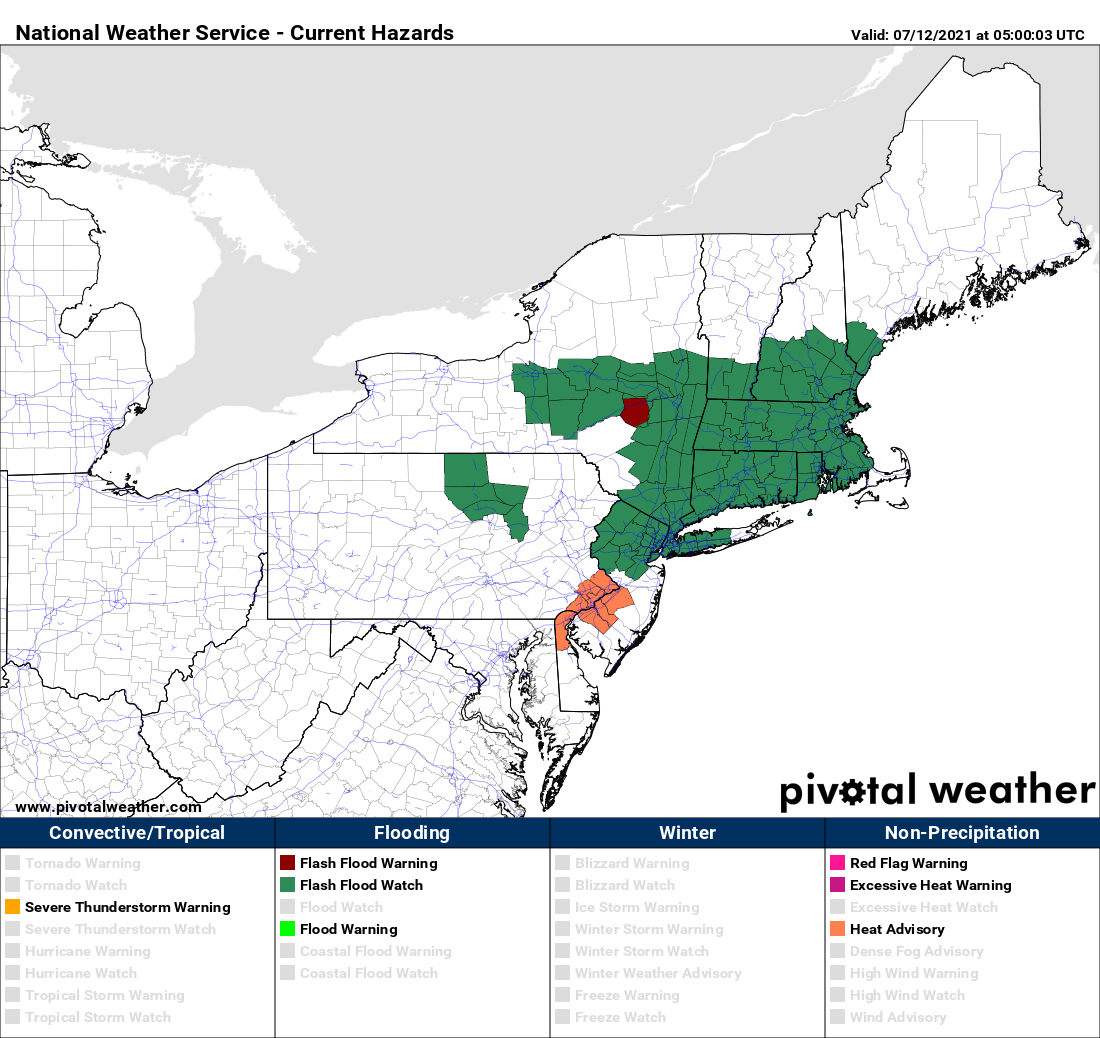
Flash Flood Watches are in effect for much of the region. Image provided by Pivotal Weather.
A warm front is going to take its time crossing the region today and Tuesday. A wave of low pressure riding along the front will bring in rain today, some of which may be heavy. Given the amount of rain we’ve had over the past 2 weeks, the ground is already saturated in many areas, so additional rain will lead to flooding problems. As a result, flash flood watches have been issued for much of the region. Tuesday looks to be drier, but still on the cool side, as the front will take its time lifting northward. A few showers can’t be ruled out.
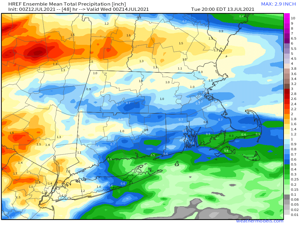
Some locally heavy rainfall is possibly today, especially north of the Mass Pike. Image provided by Weathermodels.com
The front finally lifts through on Wednesday, allowing warm to hot and humid weather to return, and it will remain in place into Saturday. With the hot and humid weather will come a daily chance for showers and thunderstorms. Those showers and storms will become more numerous on Sunday as a cold front moves in.
Saturday looks to be the hottest day across the region. Image provided by WeatherBell.
Monday: Plenty of clouds with periods of rain and showers, mainly during the morning. High 67-74.
Monday night: Mostly cloudy with a few showers possible. Low 58-65.
Tuesday: Clouds and a few sunny breaks, chance for a shower or two. High 68-75.
Tuesday night: Partly to mostly cloudy. Low 59-66.
Wednesday: More clouds than sun with scattered showers and thunderstorms possible. High 76-83.
Thursday: A mix of sun and clouds, chance for a late-day shower or thunderstorm. High 79-86.
Friday: Partly sunny, a shower or thunderstorm may pop up. High 82-89.
Saturday: A mix of sun and clouds, breezy, showers and thunderstorms possible late in the day and at night. High 82-89.
Sunday: Partly to mostly cloudy with scattered showers and thunderstorms. High 78-85.
After a chilly and wet weekend, heat and humidity are set to return to the region.
Our pesky upper-level low pressure area finally pulls away and high pressure builds in today, bringing some sunshine and warmer temperatures back into the region. A warm front will move through tonight, and it may produce a few showers and thunderstorms, but the more noticeable impact will be an increase in humidity once again. This sets up a hot and humid day on Tuesday. Many locations may top 90, and heat indices will be well into the 90s across the region. A weak boundary will move in during the afternoon though, and this may trigger showers and thunderstorms, some of which could become strong to severe. Any storms that do form could produce gusty winds, frequent lightning, and heavy downpours. If you’ve got outdoor plans for Tuesday afternoon and evening, keep an eye to the sky and on the radar, and be prepared to head indoors.
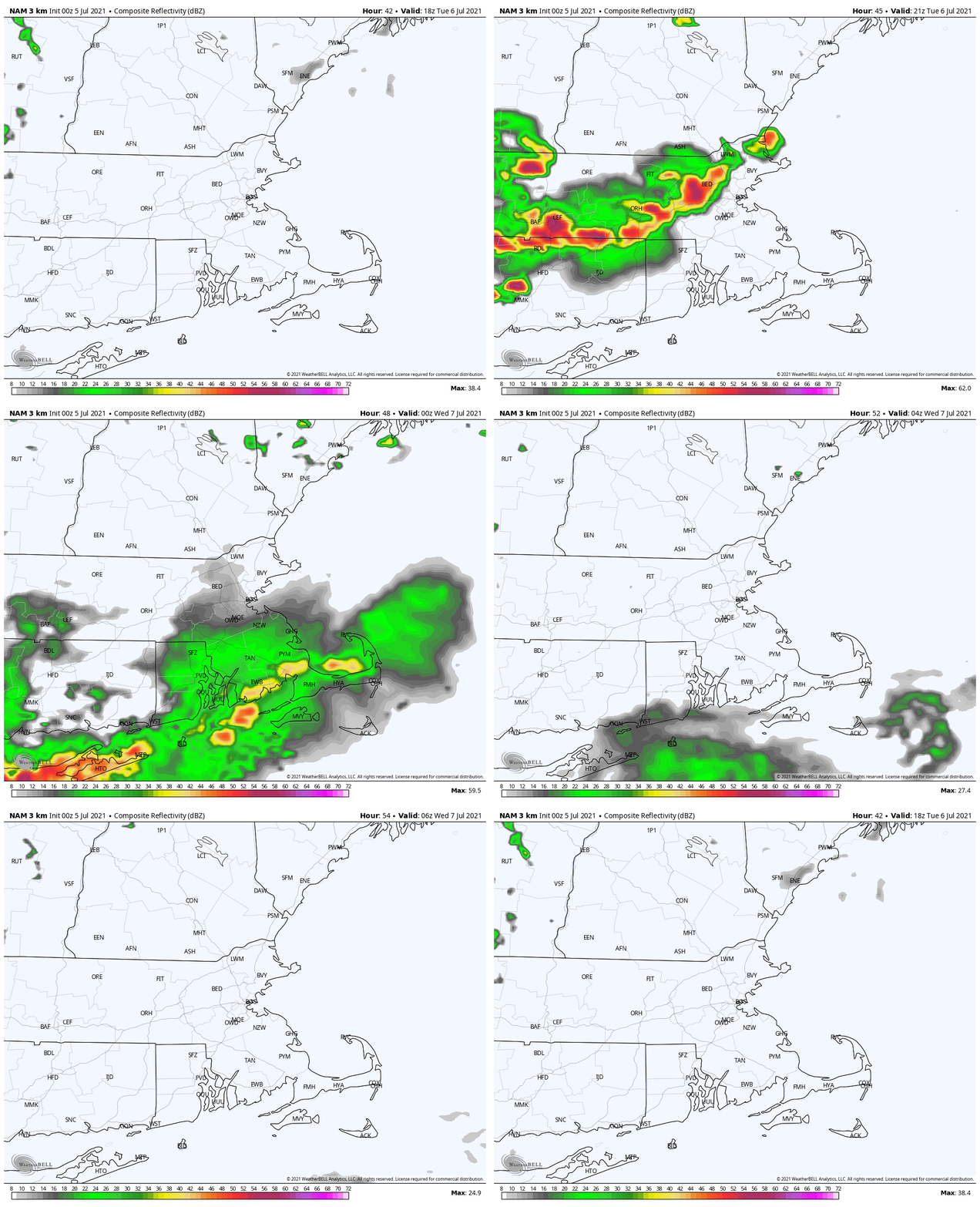
Strong to severe thunderstorms may cross the region Tuesday afternoon. Loop provided by WeatherBell.
Wednesday looks to be very warm and humid once again, but temperatures will depend on how much cloud cover there is. A cold front will be approaching from the north and west, and this will produce another round of showers and thunderstorms during the afternoon and evening. This is where forecast confidence drops significantly. That front will eventually stall out near or just south of the region. Where it stalls out will have a big impact on Thursday temperatures, with warm and humid air still in place to the south, but cooler air to the north. Complicating things is the fact that a wave of low pressure may ride along the front, bringing in some rain once again.
The models have a wide variety of ideas about Thursday’s temperatures. Images provided by Pivotal Weather.
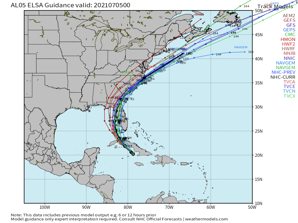
If Thursday wasn’t complicated enough, on Friday we may have to deal with Elsa or its remains. We’re not expecting Elsa to make a direct hit on New England. It should be heading out to sea well to the south. However, it may be close enough to interact with that frontal boundary, and send more rain into the region. It also may produce some gusty winds across the Cape and Islands, and some rough seas, especially along the South Coast.
Elsa or its remains should stay pass south of New England. Image provided by Weathermodels.com
We should dry out on Saturday with a warm day expected, but humidity will return on Sunday, along with the chance for more showers and thunderstorms as another frontal boundary approaches the region.
Monday: Becoming partly to mostly sunny. High 71-78.
Monday night: Partly cloudy, chance for a few showers or thunderstorms. Low 60-67.
Tuesday: Partly sunny, breezy at times, more humid, showers and thunderstorms are possible during the afternoon, some may be strong to severe. High 84-91, cooler along the South Coast.
Tuesday night: Any showers or storms end in the evening, otherwise partly cloudy. Low 65-72.
Wednesday: A mix of sun and clouds, humid, showers and thunderstorms possible during the afternoon and evening. High 84-91, cooler along the South Coast.
Thursday: Partly to mostly cloudy with a chance for rain or showers. High 76-83, possibly cooler across southern New Hampshire and northern Massachusetts.
Friday: Plenty of clouds, more rain or showers possible. High 77-84.
Saturday: Becoming partly sunny. High 77-84.
Sunday: Intervals of clouds and sunshine, showers and thunderstorms possible during the afternoon and evening. High 80-87.
If you like heat and humidity, then the first half of the week is perfect for you. If you don’t, well, the end of the week and the weekend might be better, but certainly not perfect.
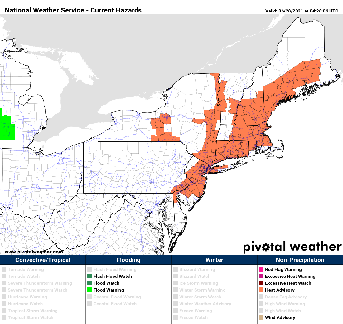
Heat Advisories are in effect for much of the Northeast today. Image provided by Pivotal Weather.
We start the week off with high pressure anchored off the Eastern Seaboard, pumping hot and humid air into the region. Most locations away from the South Coast should get well into the 90s today, tomorrow, and Wednesday. With the humidity factored in, it’s going to feel like it’s near or over 100 degrees. That’s why Heat Advisories have been issued for much of the area. At night, it’ll remain warm and muggy, with lows generally in the 70s. A few showers and thunderstorms may pop up Tuesday and again on Wednesday afternoon, providing a little late-day relief.
Tuesday looks like the hottest day, but we think the GFS might be overdoing things a little on Wednesday. Image provided by WeatherBell.
A cold front will move in late Wednesday or early Thursday, taking the edge off the heat, but with some more widespread showers and thunderstorms accompanying it. Beyond that, things get a little tricky. That front is expected to wash out near or just south of the region on Thursday. Waves of low pressure will ride along it, with showers and thunderstorms possible at times from Friday into the weekend, but this will also depend on how much southward progress the front makes before it washes out. If it’s far enough to the south, then the shower activity may stay a little farther south. No matter where it stalls, we’re looking at one or possibly two very cool days for the end of the week and start of the weekend. Temperatures should start to moderate again for the Fourth of July.
Temperatures on Friday could be 30-40 degrees cooler than Wednesday, if you believe the GFS. Image provided by Weathermodels.com
Monday: Partly sunny, hot, and humid. High 90-97, cooler along the South Coast.
Monday night: Clear to partly cloudy, just a slight chance for a shower or two. Low 70-77.
Tuesday: Sunshine and some afternoon clouds, hot, and humid., a few showers and thunderstorms are possible late in the day. High 91-98, cooler along the South Coast.
Tuesday night: Clear to partly cloudy, any showers or storms end during the evening. Low 69-76.
Wednesday: Partly to mostly sunny, breezy, hot, and humid, showers and thunderstorms are possible during the afternoon and evening. High 89-96 cooler along the South Coast.
Thursday: More clouds than sun with scattered showers and thunderstorms. High 81-88.
Friday: Plenty of clouds and much cooler with more showers possible, especially south of the Mass Pike. High 71-78.
Saturday: Partly to mostly cloudy, chance for showers and thunderstorms. High 68-75.
Fourth of July: More clouds than sun with more showers and thunderstorms possible. High 74-81.