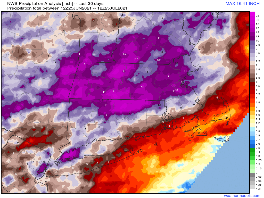
July has featured record or near-record rainfall across the region, but as it comes to a close, so does the very wet pattern we’ve been stuck in.
We start the week off with high pressure building in today, bringing us sunshine and warm temperatures, with a few places possibly getting to 90 this afternoon. Humidity levels will be fairly comfortable as drier air settles into the region. Our dry weather won’t last long as a cold front approaches on Tuesday, with some showers and thunderstorms accompanying it during the afternoon and evening. It’ll be quite warm ahead of the front again, with temperatures well into the 80s. Drier air settles back in on Wednesday along with cooler temperatures, but again, the dry air will be short-lived. Another frontal system approaches on Thursday with more showers and thunderstorms likely.
By Friday, we’ll have an upper-level trough settling into the Northeast, which means that we could see a few showers popping up during the afternoon. High pressure builds in on Saturday with cool and dry conditions. Yet another frontal system approaches on Sunday, with another round of showers and thunderstorms possible.
Monday: Sunshine and some afternoon clouds. High 82-89.
Monday night: Clear skies. Low 61-68.
Tuesday: Increasing clouds, showers and thunderstorms likely late in the day. High 82-89.
Tuesday night: Showers and storms end in the evening, then becoming partly cloudy. Low 58-65.
Wednesday: A mix of sun and clouds, cooler. High 72-79.
Thursday: More clouds than sun with showers and thunderstorms possible late in the day and at night, breezy. High 71-78.
Friday: Partly sunny and breezy, slight chance for a shower. High 74-81.
Saturday: Partly to mostly sunny. High 71-78.
Sunday: A mix of sun and clouds, breezy, showers and thunderstorms possible late in the day. High 76-83.
Finally, we’ll leave you with this uplifting thought from the good folks at the National Weather Service office in Caribou, ME:
