After some recent chilly weather we’re going to start to warm back up and it will remain dry, but not for the entire week.
We start the week off with high pressure in control providing us with sunshine and milder temperatures into Tuesday. A weak system will pass to our north Tuesday night, sending in some clouds and possibly a shower or two, but the bulk of the rain should stay well to our north. Drier weather returns for Wednesday and Thursday, but the end of the week is when the changes happen.
Temperatures could top 60 across much of the region on Tuesday. Image provided by WeatherBell.
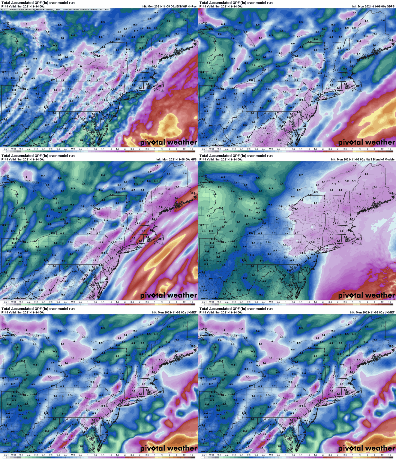
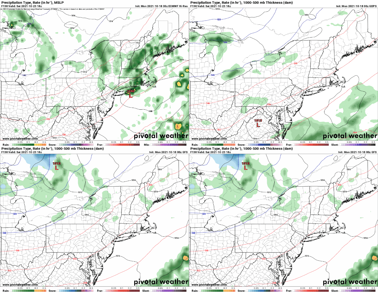
A low pressure system will move into the Great Lakes on Friday after bringing some snow to parts of the Dakotas and Minnesota. A frontal system will be located well ahead of that low, sending some showers out way for Friday. A secondary area of low pressure will develop along the front, bringing in another round of rain for Friday night into Saturday. and this batch could be heavy. Everything should push offshore by Saturday evening, with drier and cooler conditions settling in for next Sunday. A much cooler weather pattern may set up for next week, possibly hanging around for quite a while.
Parts of the region could see more than an inch of rain at the end of the week. Images provided by Pivotal Weather.
Monday: Some morning clouds, otherwise becoming mostly sunny. High 53-60.
Monday night: Clear skies. Low 35-42.
Tuesday: Plenty of sunshine. High 58-65.
Tuesday night: Becoming partly to mostly cloudy, slight chance for a shower late at night. Low 39-46.
Wednesday: Early clouds and possibly a shower, then becoming partly sunny and breezy. High 55-62.
Thursday: Intervals of clouds and sun. High 51-58.
Friday: Cloudy and breezy with showers likely, becoming a steady rain at night. High 57-64.
Saturday: Periods of rain and showers, ending in the afternoon. High 55-62.
Sunday: Sunshine and some afternoon clouds, breezy. High 48-55.
Much of the upcoming week is going to dry but it will get progressively cooler.
A cold front will cross the region with little fanfare today, but temperatures will remain on the mild side. Another weak front moves through on Tuesday with just a few showers accompanying it, but temperatures will turn a little cooler once again. Another weak disturbance moves through on Wednesday with little fanfare, but again, temperatures will turn a little cooler behind it as well. A weak system will pass by to the south Thursday into Friday, possibly close enough for a few showers south of Boston, but the flow around it will bring even cooler weather into the area. High pressure then builds in next weekend.
Temperatures will be below normal for much of the upcoming week. Loop provided by Weathermodels.com
Monday: Mostly sunny. High 54-61.
Monday night: Becoming partly to mostly cloudy. Low 34-41.
Tuesday: More clouds than sun, slight chance for a shower. High 50-57.
Tuesday night: Clearing. Patchy frost is possible. Low 32-39.
Wednesday: Sunshine and some afternoon clouds. High 47-54.
Thursday: Partly to mostly cloudy, chance for a shower or two south of Boston late in the day and at night. High 45-52.
Friday: Chance for an early shower south of Boston, then becoming partly sunny. High 46-53.
We can sum up much of the upcoming week in one word: Awful. Yeah, it’s gonna suck. Let’s get right to the ugly details.
Showers will taper off this morning as a warm front stalls out near or just south of the region and a wave of low pressure riding along the front departs. However, with the front hanging out nearby, we’ll still have plenty of clouds, some drizzle and fog, and maybe another shower or two. Depending on where the front stalls out, some milder air may move into the South Coast, but for most of us, it won’t be that mild. Of course, today’s shower activity is the opening act for what follows.
Mild air may try to move into the South Coast today depending on how far north and warm front gets. Image provided by Weathermodels.com
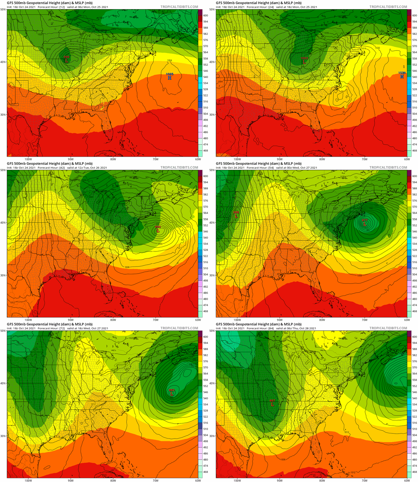
Our first coastal storm of the fall is on tap for Monday night into Wednesday, and possibly even early Thursday. A strong upper-level disturbance will move toward the East Coast from the Midwest while a second one moves out of the Gulf of Mexico. These two will meet up off the East Coast, resulting in an area of low pressure developing and rapidly strengthening south of New England. As an upper-level low pressure area also develops, it will capture the developing storm at the surface, which will prevent it from moving too much for about 24 hours. If it were late December or January, instead of late-October, this would likely be an impressive blizzard across the interior.
The GFS model shows the evolution of both the surface low pressure area and the upper-level low. Loop provided by Tropical Tidbits.
So what does all this mean for us? A lot. As in, a lot of rain and a lot of wind. Rain will redevelop Monday night, and continue into Wednesday, possibly heavy at times. Much of the region will likely receive 2-4 inches of rain, but many models are showing the potential for totals of 5-6 inches or more. As of the time of this writing, there were Flash Flood Watches in effect for southern Connecticut, but we expect them to be expanded into parts of Rhode Island and Massachusetts at least by Monday morning.
Rainfall totals on the models through Wednesday evening range from impressive to excessive. Images provided by Pivotal Weather.
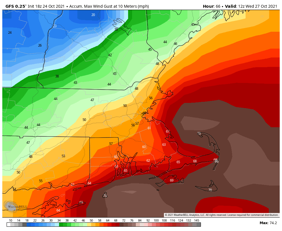
As for the wind, as the storm rapidly develops, the pressure gradient between it and the high pressure area to the north will result in increasing winds. As is usually the case, the strongest winds will be found along the coast, but even inland locations, especially across eastern Massachusetts and Rhode Island, will feel the winds. Northeast winds will be sustained at 25-35 mph, with gusts to 60 mph or higher expected. The strongest winds are likely from Tuesday morning into Wednesday afternoon, when a High Wind Watch is in effect. The combination of strong winds, heavy rain, and trees that still have most of their leaves will increase the threat for power outages, so charge up your electronics today just to be safe. As the leaves all come down, there are two other issues to worry about. First, they will clog up some of the storm drains, resulting in additional flooding, but they’ll also result in slippery roads, so keep this in mind if you’re out driving.
Wind gusts could top 60 mph Tuesday into early Wednesday, especially south of Boston. Image provided by WeatherBell.
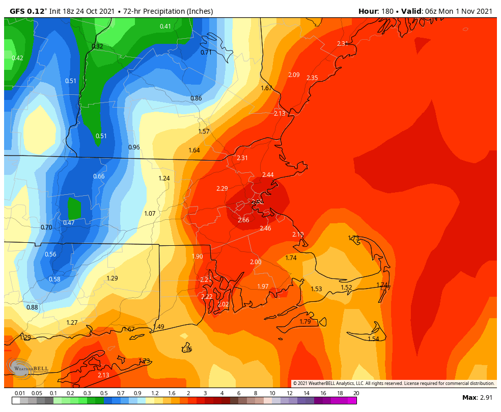
The storm system finally pulls away on Thursday, but winds may remain gusty, and a few lingering showers are also possible, especially across Cape Cod in the morning. High pressure builds in with some clearing and drier air later Thursday and Thursday night. Then things are nice for Friday and the weekend, right? Yeah, not so much. Another low pressure system will move out of the Midwest while an upper-level low pressure area also moves eastward. That means more rain developing at some point later Friday, and continuing off and on through the weekend. This storm shouldn’t be as potent as the one on Tuesday, so we probably won’t have as much wind or rain, but the weekend isn’t looking that great right now, and this includes trick-or-treating weather Sunday evening. Right now, the models have this storm a lot further north than the first storm, which would result in milder temperatures. There’s still a lot of uncertainty with this part of the forecast, so maybe it won’t be that bad (yeah, right). We should have a better idea what to expect when we get to our Weekend Outlook on Thursday.
Halloween weekend could be quite wet, but not as wet as the next few days. Image provided by WeatherBell.
Monday: Cloudy and breezy with showers tapering off in the morning, with periods of drizzle and possibly another shower or two in the afternoon. High 48-55 north and west of I-95, 55-62 south and east of I-95, except 62-79 south of Route 44.
Monday night: Breezy with Rain likely. Low 43-50 north and west of Boston, 50-57 south and east.
Tuesday: Very windy with rain, heavy at times. High 50-57 north and west of Boston, 57-64 south and east.
Tuesday night: Periods of rain and showers, very windy. Low 44-51.
Wednesday: Mostly cloudy and breezy with more showers likely. High 50-57.
Thursday: A lingering shower or two across Cape Cod early, some sunshine develops in the afternoon, especially north and west of Boston, still breezy near the coast. High 51-58.
Friday: Some early sun, then clouds return, rain develops at night, breezy. High 52-59.
Saturday: Periods of rain and showers. High 57-64.
Sunday: Cloudy with more rain and showers possible. High 57-64.
Cooler weather has finally arrived, and it will be here for part of the upcoming week.
A chilly night is expected across the region tonight. Image provided by WeatherBell.
High pressure continues to build into the region today with temperatures running a few degrees cooler than we had on Sunday. With an upper-level disturbance still moving through, we’ll see clouds develop, and a few pop-up showers are possible in the afternoon. High pressure remains in control on Tuesday with dry and seasonably cool conditions. By Wednesday, the high moves offshore, and a southwest flow will bring milder air back into the area. Thursday also looks warm, but clouds will be on the increase as a cold front approaches from the west. That front will move through Thursday night or early Friday with a few showers, but the bigger story is what happens behind the front. Friday’s temperatures will be determined by when the front moves through, but for now at least, it looks mild again, at least to start.
Thursday should be quite a mild day. Image provided by Weathermodels.com
Even cooler air settles into the region next weekend. Temperatures likely won’t get out of the 50s on Sunday, with many places likely dropping into the 30s at night. Before you complain too much, some of the models show the potential for lake-effect snow in parts of western and northern New York next weekend. We’ve also got to keep an eye on a low pressure system that may try and move up the coast on Saturday, but for now at least, it looks like it should stay offshore.
We’re keeping an eye on a potential system for Saturday. Images provided by Pivotal Weather.
Monday: A mix of sun and clouds, breezy, chance for a pop-up shower or two. High 54-61.
Monday night: Partly cloudy and quite cool. Low 38-45.
Tuesday: Sunshine and a few clouds, breezy again. High 56-63.
Tuesday night: Clear to partly cloudy. Low 44-51.
Wednesday: Partly sunny and milder. High 65-72.
Thursday: Sunshine gradually fades behind thickening clouds, showers may develop overnight. High 66-73.
Friday: Intervals of clouds and sunshine, chance for some showers early. High 63-70.
Saturday: Partly sunny, chance for a shower. High 54-61.
Sunday: A mix of sun and clouds, breezy. High 52-59.
All the signs are there that we’re well into fall – the leaves are changing colors, baseball’s playoffs are in full swing, football is well into the season, hockey starts up this week, basketball next week, pumpkin flavored everything has invaded everywhere, but someone forgot to give Mother Nature the memo, as we’ve got some warm weather on the way for much of the week.
Normal high temperatures for mid-October are in the lower to middle 60s. Image provided by Weathermodels.com
We start the week off with high pressure to the north and low pressure well south of New England. The low may produce a few showers near the South Coast this morning, but high pressure should eventually win out, with some sunshine developing during the afternoon. Even more sunshine and milder temperatures are expected on Tuesday as the high continues to build in. A weak system moves through on Wednesday with little fanfare except for some clouds and just a slight chance for a shower. High pressure returns for Thursday and Friday with dry and warm conditions.
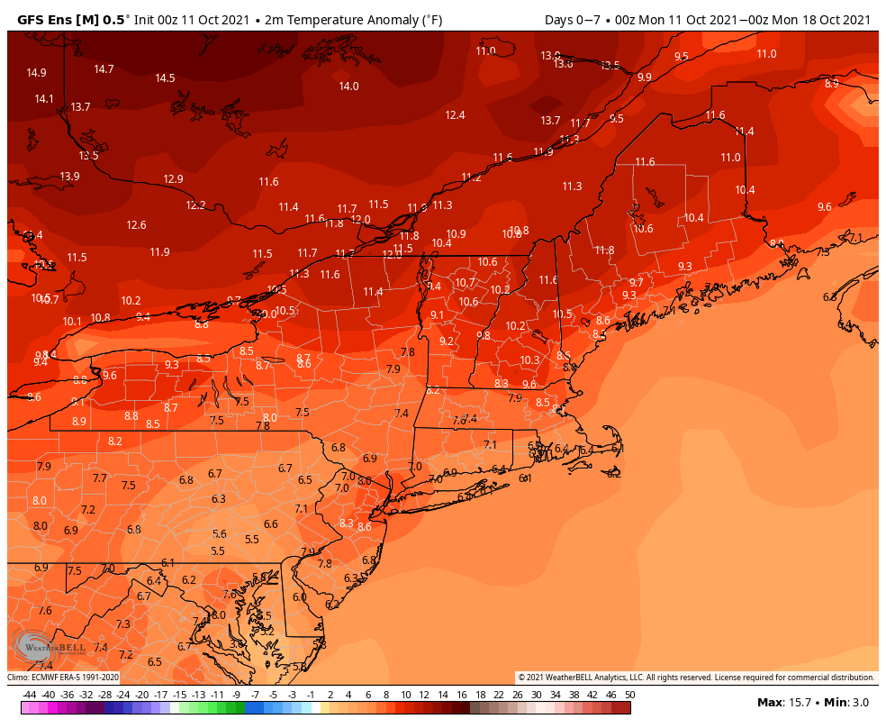
Temperatures will average 6-10 degrees above normal across the region this week. Image provided by WeatherBell.
Next weekend is where things get a little uncertain. A cold front will be approaching the region, and it’s timing is still a bit of a question mark. Saturday looks quite mild at this point, but as the front draws nearer, some showers and possibly thunderstorms are likely ahead of it. Much of the day should remain dry, with showers holding off until nightfall, but this is far from certain. The front likely moves through at night, with much cooler air settling in on Sunday. However, if the front doesn’t move through until sometime Sunday, as at least one model shows, then Sunday could start off quite warm before temperatures drop during the afternoon. We should have better clarification of the timing of the front for our Weekend Outlook on Thursday.
The timing of next weekend’s system is still in question. Images provided by Pivotal Weather.
Monday: A few showers near the South Coast early, otherwise plenty of clouds with some sunny breaks. High 64-71.
Monday night: Becoming partly cloudy. Low 49-56.
Tuesday: Partly sunny. High 68-75.
Tuesday night: Clear to partly cloudy. Low 50-57.
Wednesday: Partly sunny, slight chance for a shower. High 69-76.
Thursday: Partly sunny. High 69-76.
Friday: Becoming partly to mostly cloudy. High 69-76.
Saturday: A mix of sun and clouds, showers and possibly some thunderstorms likely at night, breezy. High 68-75.
Sunday: Showers end early, then becoming partly to mostly sunny, breezy, and cooler. High 61-68.
A wet start to the week, then we dry out. Wet weather may return for the end of the week.
A frontal system is stalled out across the region, and waves of low pressure will ride along it, bringing in rain, some of it heavy, Monday and Monday night, with showers tapering off on Tuesday. High pressure builds in for Wednesday through Friday, with dry and gradually milder weather. Next weekend is a bit uncertain, as high pressure will remain to the north while low pressure tries to move up from the south. We’ll see which feature wins out.
Most of the models agree on a general 1-2 inches of rain by the end of the day Tuesday, with some showing heavier amounts. Images provided by Pivotal Weather.
Monday: Cloudy with periods of rain and showers, some of which may be heavy. High 56-63.
Monday night: Cloudy with more rain and showers. Low 51-58.
Tuesday: Cloudy with a few showers. High 58-65.
Tuesday night: Becoming partly cloudy. Low 48-55.
Wednesday: Partly sunny and milder. High 63-70.
Thursday: Mostly sunny. High 68-75.
Friday: Partly to mostly sunny. High 66-73.
Saturday: More clouds than sun, cooler. High 61-68.
Sunday: Mostly cloudy with a chance for showers. High 63-70.
Editorial note: Thursday’s Weekend Outlook is normally published during the mid-to-late afternoon. This week, it will likely not be published until sometime Thursday night, so you’ll probably be able to read it Friday morning.
Baseball’s regular season is in the home stretch, football is well underway, hockey is starting up, and pumpkin everything is showing up everywhere. It’s definitely fall now. Mother Nature is going to get in on the act this week too. Goodbye shorts, hello light jackets or sweatshirts.
It’s been a warm September, but changes are coming as we near the end of the month. Image provided by the Northeast Regional Climate Center.
The week starts off on a warm note with high pressure still in control, but changes are coming. A cold front dropping southward will produce some showers tonight and Tuesday, with a rumble of thunder possible as well. High pressure builds in behind the front on Wednesday with cooler and drier conditions. A wave of low pressure will ride along the front to our south Wednesday night and Thursday, with another period of showers likely. Friday looks like a typical fall day to start October. An upper-level low pressure are will be moving across the region, bringing with it some clouds and possibly a few showers. High pressure should return for the weekend with dry and cool conditions.
High temperatures may struggle to reach 60 on Thursday. Image provided by WeatherBell.
Monday: Partly sunny. High 70-77.
Monday night: Mostly cloudy with a chance for a shower. Low 57-64.
Tuesday: Plenty of clouds with showers likely, possibly a rumble of thunder. High 68-75.
Tuesday night: Partly to mostly cloudy, any lingering showers end in the evening. Low 46-53.
Wednesday: A mix of sun and clouds. High 61-68.
Thursday: Mostly cloudy with some showers possible. High 57-64.
Friday: Early sun, then clouds return, slight chance for an afternoon shower. High 60-67.
That line from the Rush song “Time Stand Still” is talking about the next couple of days. Summer officially ends with the autumnal equinox at 3:20pm on Wednesday.
We start the week off with high pressure in control, providing us with sunshine and seasonably mild temperatures. As the high moves offshore on Wednesday, southerly winds will bring warmer and more humid air into the region. There may be enough moisture around to trigger a shower or two across the interior, but for the most part, the day will remain dry.
Tuesday morning could be a little chilly across the interior. Image provided by WeatherBell.
The end of the week is where things get tricky. A slow-moving frontal system will head this way, but the models don’t agree on the timing of the system. One model has the system bring us a rainy day on Thursday, with the showers ending early Friday. A couple of others have just a few showers on Thursday, with the bulk of the rain moving in on Friday and lingering into part of Saturday as the front really slows down. Given the trends recently, we’re going to lean toward the slower timing for now. This will impact Sunday’s forecast as well, as another system will be following, and if the first system takes longer to move out, then then second system will take longer to move in. We should have some more clarity on this for our Weekend Outlook on Thursday.
The models don’t agree on the timing, but they all show a pretty decent amount of rainfall for the end of the week. Images provided by Pivotal Weather.
Monday: Sunshine and a few afternoon clouds. High 68-75.
Monday night: Clear to partly cloudy. Low 48-55.
Tuesday: A mix of sun and clouds. High 67-74.
Tuesday night: Partly to mostly cloudy. Low 55-62.
Wednesday: Partly sunny, chance for a few showers, mainly across the interior. High 71-78.
Thursday: Intervals of clouds and sun, a few showers are possible, mainly across the interior again. High 72-79.
Friday: Mostly cloudy and breezy with showers likely, possibly some steady rain at night. High 70-77.
Saturday: Showers end by early afternoon, some sunny breaks may develop in the afternoon, especially across the interior. High 68-75.
A return to a wet pattern appears to be heading our way for a chunk of the upcoming week.
The week is actually going to start off with a line of showers and thunderstorms crossing the region this morning. Depending on when you read this, they may already be offshore. As the line moves through, they’ll produce some gusty winds, lightning, and downpours, especially north of the Mass Pike. Once they finally move through, high pressure will build in, with a rather nice day expected today. Unfortunately, today is the best it will be for a while. Winds will shift into the east on Tuesday, bringing in some clouds, but also cooler temperatures. A warm front will move through at night, with some showers accompanying it.
The line of showers and thunderstorms should weaken as it moves through this morning. Loop provided by Weathermodels.com
The middle to latter portion of the week looks the most unsettled, but also has the most uncertainty associated with it. Wednesday looks like a warm and humid day, but we’ll have a cold front approaching, which will likely produce some showers and thunderstorms. Depending on the timing of the front, which is still a big question, some of those storms could become strong to severe. Behind the front, cooler weather will settle in on Thursday, but with the front stalled out nearby, and a southerly flow aloft, we’ll still have plenty of moisture around, so more showers are likely.
Wednesday is looking quite warm, especially for mid-September. Image provided by WeatherBell.
This brings us to Friday, which is the day with the most uncertainty at this point. We’ll continue to have tropical moisture flowing northward into the region, so more rainfall is likely. The question is, will it just be a steady stream of moisture, or will it organize into a system? Some of the models do try to develop it into an organized low pressure area, which could become a tropical depression or even a tropical storm. As of their early morning update, the National Hurricane Center gave the system a 50% chance of developing into a tropical depression over the next 5 days. (We’ll have a more detailed post on the tropics this afternoon, where we’ll take a look at this system, Tropical Storm Nicholas, which will bring heavy rain to Texas, and two other systems we’re watching in the Atlantic.) Further complicating things is the potential for the remains of Nicholas to get infused into the system, resulting in even more rainfall. Either way, it looks like Friday will be a cool, wet day, with the potential (for now) for heavy rainfall. Moisture may hang around on Saturday with plenty of clouds and possibly some more showers. Sunday may see some clearing, but that’s a low-confidence forecast right now.
As you’d expect in mid-September, the Atlantic is fairly active right now. Image provided by the National Hurricane Center.
Monday: Showers or thunderstorms early this morning, becoming partly to mostly sunny. High 73-80.
Monday night: Clear to partly cloudy. Low 54-61.
Tuesday: Some early sun, then clouds filter back in. High 68-75, coolest along the coast.
Tuesday night: Becoming mostly cloudy with showers developing. Low 60-67.
Wednesday: Mostly cloudy, chance for showers and thunderstorms, especially late in the day and at night. High 79-86.
Thursday: Cloudy with occasional showers. High 70-77.
Friday: Cloudy and cool with a chance of rain. High 69-76.
Saturday: More clouds than sun, chance for some more showers. High 73-80.
The first full week of September will turn out to be rather nice for the most part.
We’re starting things off this Labor Day morning with some clouds and lingering showers, but skies should clear out this afternoon as a cold front pushes offshore. As an upper-level disturbance rotates through, we could see a stray shower or thunderstorm pop up in the afternoon, mainly north and west of Boston. Clear skies, light winds, and low humidity will result in radiational cooling tonight, which means it could be rather cool in some spots when you wake up Tuesday morning. High pressure builds in for Tuesday, resulting in a rather fine and dandy day with seasonably mild temperatures.
Normal high temperatures for early September are generally in the middle 70s. Image provided by Weathermodels.com
Humidity returns on Wednesday as a warm front moves through, but right now, it looks like most of the shower activity will hold off until after dark. Showers are likely at night, with a rumble of thunder possible as well. The showers end on Thursday as a cold front moves through the region. The end of the week and the weekend look dry with high pressure building back in. Another front may start to approach late Sunday with more clouds, but again, it looks like any shower activity should hold off until nightfall.
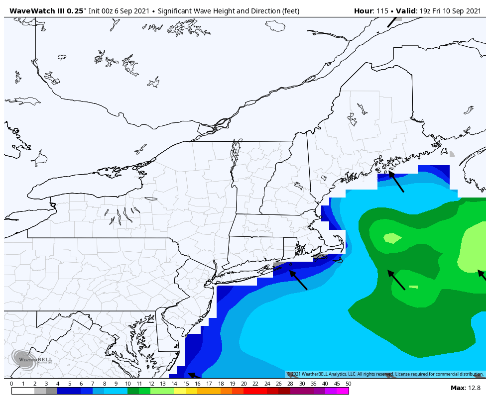
Hurricane Larry should be passing well to our east late this week, but it will generate large swells that will impact the beaches and coastal waters late in the week and into the weekend. This will increase the threat of rip currents. Keep this in mind if you’re planning to head to the beach or out on a boat late this week.
Hurricane Larry will send large waves toward the shoreline late this week. Image provided by WeatherBell.
Monday: Any lingering showers end in the morning, then becoming partly to mostly sunny with a slight chance for an afternoon shower or thunderstorm. High 74-81.
Monday night: Clear skies. Low 53-60.
Tuesday: Sunshine and a few clouds. High 71-78.
Tuesday night: Clear skies. Low 55-62.
Wednesday: Sunshine fades behind increasing clouds, breezy, showers develop at night. High 77-84.
Thursday: Mostly cloudy with some showers likely, ending during the afternoon. High 72-79.