Unlike the last storm, which we admittedly underestimated, this storm is likely not going to live up to expectations for parts of the region, mainly north and west of Boston.
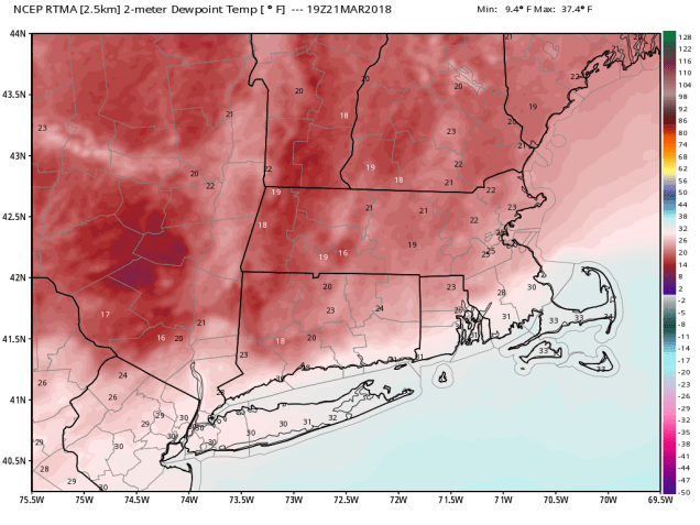
As the storm starts to move in this afternoon and evening, there is a lot of dry air in place. Dewpoints are only in the upper teens and 20s across much of the region. So, as the moisture from the storm moves in, it’s moistening up the atmosphere slowly, but anything that falls from the clouds is evaporating before hitting the ground.
Very dry air remains in place across the region this afternoon. Image provided by WeatherBell.
Eventually, the moisture will overcome this drier air, but the storm is also tracking a little farther to the south than we were thinking yesterday. As a result, snowfall totals will be considerably lower north and west of Boston than our previous forecast. Of course, this also means that there could be a bit more snow than we were thinking south of Boston, especially across Cape Cod, though some rain could still mix in there, which would limit amounts a bit.. This scenario was first hinted at by the ECMWF model 2 days ago, and most meteorologists thought of it as an outlier, since most of the other model guidance was painting a snowier scenario. We tended to discount it as well, but in the back of our minds, we kept hearing a phrase that a noted meteorologist has repeated over and over to us “Ignore the Euro at your own peril.”
Hour-by-hour forecast for the storm based on the HRRR model from 2pm Wednesday through 8am Thursday. Image provided by Weathermodels.com
So, with that in mind, we are revising our forecast to be closer to what the European model is showing (but not exactly):
Southeastern Massachusetts/Cape Cod: 5-9″ (possibly less on the Outer Cape if rain mixes in)
I-95 Corridor (Boston/Providence): 4-7″
MetroWest: 3-5″
Merrimack Valley/NH Seacoast: 2-4″
Southern NH (Nashua/Manchester): 1-3″
This will still be a fairly wet snow south of Boston, so keep that in mind when you go out to shovel it tonight or Thursday. Once the sun comes up, thanks to the higher sun angle, any additional accumulations are not expected on paved or treated surfaces. Everything should wind down and end completely by early Thursday afternoon.
Snowfall forecast from the ECMWF model through Thursday evening. Image provided by Weathermodels.com
As this storm moves into Atlantic Canada, and upper-level low will settle into the Northeast for Friday and Saturday, keeping us cloudy and cool. An impulse riding around the system may bring some light snow and snow showers in on Saturday, but accumulations will likely be on the light side, if we get much at all.
“Once more unto the breach, dear friends, once more.”
At 12:15 EDT this afternoon, the sun was directly over the Equator, marking the Vernal Equinox, or as it is more commonly known, the start of Astronomical Spring. Here in New England, astronomical seasons don’t have really have much influence on the weather, at least the start and end of those seasons. Take this week for example. Tomorrow is the first full day of spring, but we’re expecting another snowstorm. Yup, that’d be the fourth one this month.
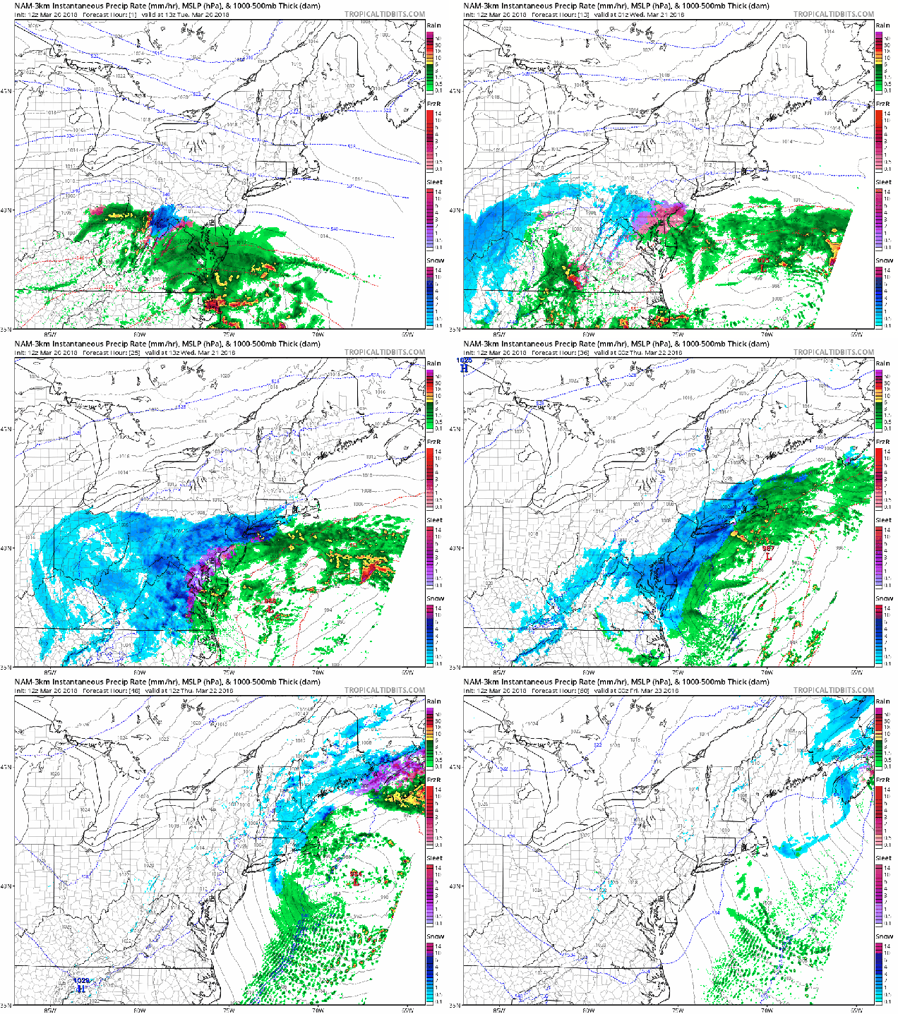
There’s actually a storm passing well south of New England today, so in a sense, we were spared a bit. It’s producing some rain and snow across the Mid-Atlantic states and sending a veil of high clouds across New England, dimming the sunshine this afternoon. Another storm will quickly follow on Wednesday, thickening up the cloud cover. Let’s start out by saying that this storm will not be as bad as the ones we’ve had earlier this month. We’re not expecting blizzard conditions. Oh, we’ll still have a decent amount of snow, strong winds, and some coastal flooding issues, but not at the magnitude of the earlier storms.
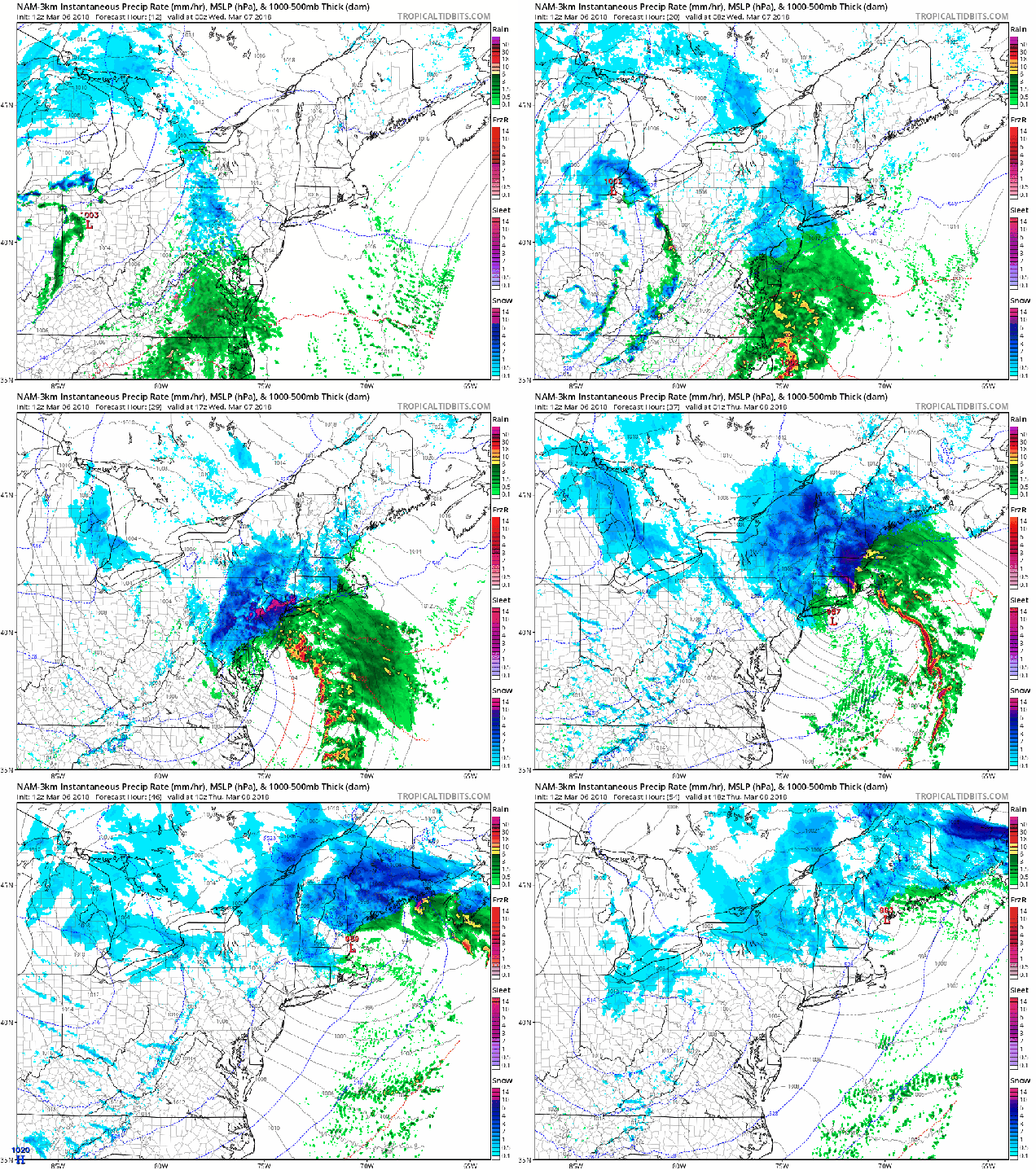
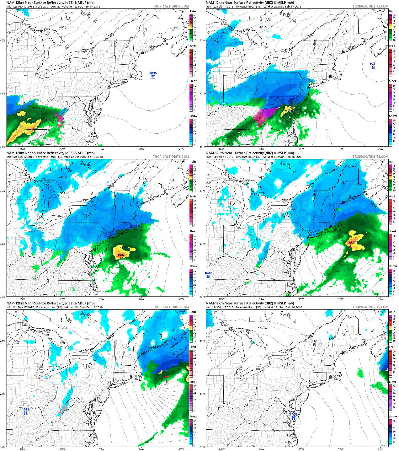
Forecast for the storm’s progression based on the High-Resolution version of the NAM model. Loop provided by Tropical Tidbits.
We’ll start with the winds and coastal flooding. Tides are astronomically high again this week, so the biggest concern will be at high tide at northeast and north facing beaches, especially the high tides early Wednesday and Thursday morning, as well as Wednesday afternoon. A coastal flood watch is in effect for the early Thursday morning high tide across Plymouth County as well as the Cape and Islands. As for the winds, sustained winds of 20-30 mph are expected, especially along the coast, with gusts of 40-50 mph, perhaps as high as 60 mph across the Cape and Islands, Southeastern Massachusetts, and parts of Rhode Island. Combine that with heavy, wet snow (more on that in a moment), and yes, power outages become a concern once again.
Wind gusts for 11pm Wednesday predicted by the High-Resolution NAM model Image provided by WeatherBell.
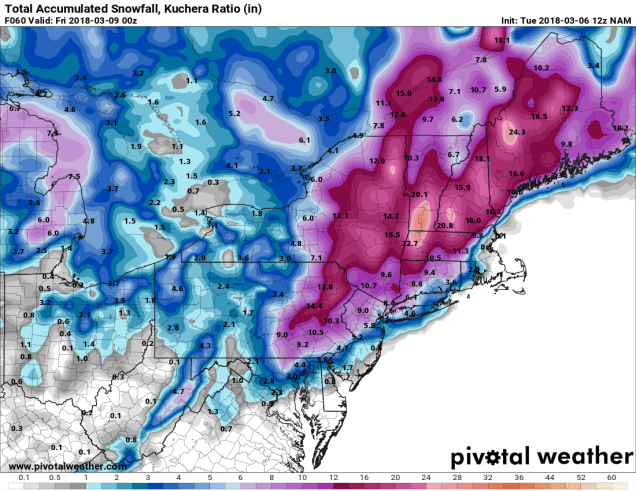
Now, for the part that most of you care about – snowfall. The snow should develop during the afternoon hours on Wednesday. While it’ll be snowing during the afternoon rush hour, it shouldn’t cause too many problems (the people on the roads, however, probably will). With the higher sun angle at this time of year (equivalent to mid-September), and only light snow expected during the daylight hours on Wednesday, accumulations will be fairly light, especially on paved surfaces. Once the sun sets, steadier snow will move in, with the bulk of the accumulating snow expected Wednesday evening into Thursday morning. While the accumulating snow will be all done Thursday morning, light snow and snow showers may linger into the afternoon. We also will likely be dealing with a rain/snow line. A change to rain seems likely across Cape Cod for a while Wednesday evening, with that changeover likely penetrating into parts of southeastern Massachusetts. The question is – how far? Right now, we don’t expect it to get past Route 44, if it even gets that far.
That brings us to the amounts. With temperatures close to freezing, this is going to be a heavy, wet snow, so keep that in mind when you go out to shovel or fire up the snowblower. Here’s what we’re thinking:
Cape Cod: 1-3″, highest totals on the Upper Cape
South Coast: 3-5″
South and East of I-95: 4-7″
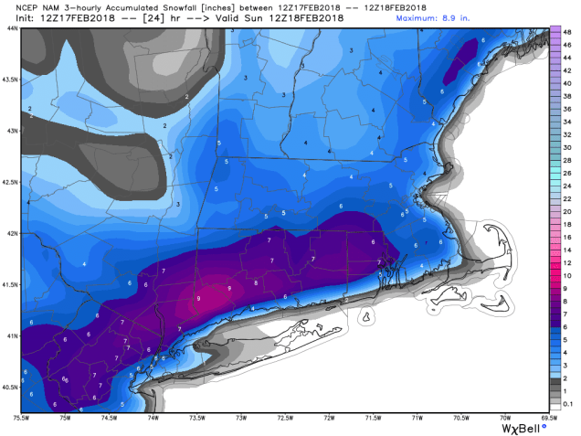
Metro Boston/MetroWest/Merrimack Valley/North Shore: 5-9″
Southern NH (Nashua/Manchester)/NH Seacoast: 4-7″
The snowfall forecast from the High-Resolution NAM model is closest to our thinking right now. Image provided by Pivotal Weather.
Once this system pulls away, an upper-level low pressure area will slowly move across the Northeast, which may give us some additional snow showers on Friday and Saturday, but we’re not expecting much accumulation (if any), with those. Beyond that – right now, the models aren’t showing any big storms over the next 2 weeks, but that is always subject to change. Remember, just a couple of days ago, most of the TV talking heads told you that this storm was going to stay offshore and we didn’t have to worry about it. As for when we can expect some actual “Spring” weather – well, the pattern looks to remain chilly right into at least early April.
So, remember just 24 hours ago when we said that we weren’t buying all of the ridiculous numbers being floated out there because we expected the models to shift the storm a bit eastward? Yeah, the opposite happened.
Hey, we’re the first ones to admit when we are wr….wro…..wro….when our forecast starts going off the track. We wait until we’re fairly sure we’ve got a good forecast before we publish, because we want you to have the best info available. Well, in this case, that didn’t work out. Luckily, we still haven’t gotten into the storm, so we have time to fix things.
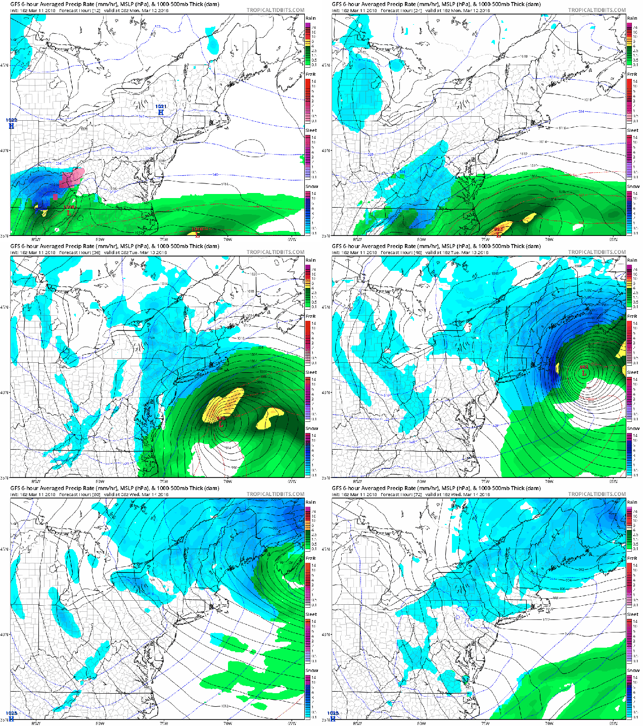
Forecast for the storm based on the GFS model. Loop provided by the College of DuPage.
The basics that we outlined last night still hold true. Low pressure will move up the East Coast and rapidly intensify, passing south and east of Cape Cod later Tuesday. Strong winds are likely, especially along the coast. Sustained winds of 20-30 mph with gusts to 50 mph inland and possibly 70 mph along the coast. We may have understated the coastal flood threat a bit, but still, any coastal flooding will be minor in nature and confined to right around high tide.
Even the timing is still close to what we were thinking last night. Precipitation should develop near or just after midnight, and quickly get heavy. Blizzard conditions are likely, mainly along the coastline, from daybreak through early afternoon. Snowfall should start to lighten up after midday, but likely doesn’t completely end until late evening or even close to midnight Tuesday night.
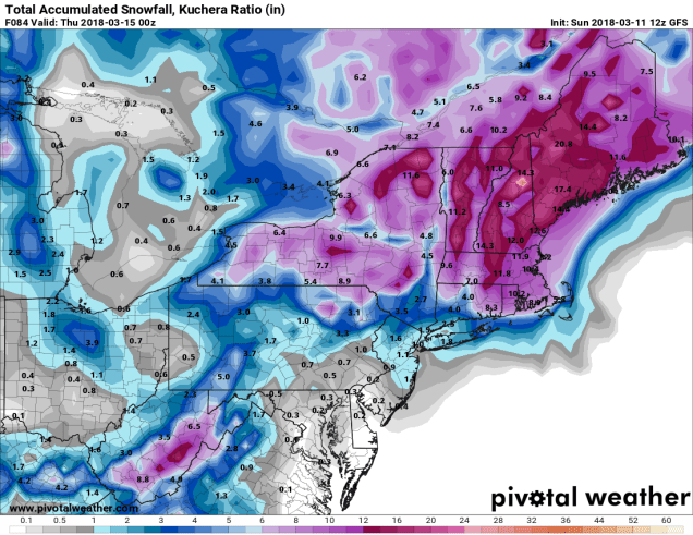
That brings us to the snowfall amounts. There are still some models that are showing amounts that border on ridiculous. As you should know by know, our forecasts, while filled with sarcasm and satire, try to be level-headed, not ridiculous. How much can you expect?
Outside of I-495: 6-12″
Merrimack Valley/Southern NH/NH Seacoast: 8-14″
Most of the remainder of Eastern Massachusetts and Rhode Island: 12-18″
The “jackpot” is likely to be across portions of Plymouth County and onto Cape Cod, where some totals of 18 to perhaps 24″ are possible. The big question here is whether any rain mixes in. This is especially possibly across the Outer Cape and Nantucket. If there is any rain, that will knock accumulations down.
The GFS model is still the closest to our current thinking for snowfall amounts. Image provided by Pivotal Weather.
Once the storm moves out, an upper-level low pressure area may trigger additional snow showers on Wednesday and again Thursday (and possibly Friday too). Oh, and since you’re all sick of snowstorms by now, depending on which model you believe, we could have as many as 3 more between now and the end of March. We’ll worry about each of those as they become a threat (or don’t).
Another week, another nor’easter. Once again, the hype train has left the station and is heading down the track at top speed. Without further delay, let’s get right to it.
Low pressure moving across the Tennessee Valley Sunday night will redevelop off the South Carolina coastline early Monday, then head up the East Coast. The storm will pass south and east of Cape Cod while rapidly intensifying. As is usually the case, this will bring strong winds and snow to the region. Obviously, the strength of the winds and the amount of snow will be dependent on how close the storm passes to New England, among other things. As you probably heard on Sunday, the vast majority of media outlets, as well as all of the Facebook Forecasters, and even the National Weather Service, are calling for very heavy snowfall from this storm. The reason for this is that many of the models are forecasting these amounts. Well, as a noted colleague has said in the past – “If the models were as good as everyone thinks, there would be no need for meteorologists”. Oh, we still think there will be some heavy snow, and we’re expecting plowable amounts, but let’s pump the brakes on the talk of “1-2 feet” or “12-18 inches”, or our personal favorite cop-out “10-14 inches+” (adding the plus so that if anything higher than that falls you can claim that your forecast was accurate).
GFS forecast for the progression of the storm on Tuesday. Loop provided by Tropical Tidbits.
Before the storm arrives, Monday will be a generally cloudy day, with temperatures right around where they should be in mid-March. Winds will start to pick up in the evening, and for most of the day on Tuesday, we’re looking at northeast winds of 20-30 mph, with gusts to 40-50 mph inland, and 60-70 mph at the coast. Yes, this may take down some additional trees, but coastal flooding will not be a problem this time, as tides are significantly lower than they were a week ago.
As for the snow, it should develop around midnight, give or take an hour or two, and quickly become steady and heavy. Heavy snow will continue into the morning, then lighten up a bit in the afternoon, winding down in the evening. If you can work from home on Tuesday, we’d recommend it. Travel will be extremely difficult in the morning, as snow could be falling at the rate of an inch an hour or more, and it will be accompanied by strong winds, creating blizzard conditions at times.
Official definition of a blizzard. Note, snowfall accumulations do not factor into this. Image provided by WCVB-Boston.
As for how much, well, as we mentioned above, we’re not going with the big amounts that many others are. Why? Well, for one, a portion of that snow is going to fall during the daytime. At this time of year, the sun angle is strong enough (equivalent to the end of September), then unless it’s falling heavily, it will have trouble accumulating. Now, it will be falling heavily in the morning, but probably not as heavily in the afternoon. So, you can slice a little off of those model snow maps right there. Another reason is that we expect the models to shift a little more with the track slightly farther offshore. That has been the trend during the day today, and if that continues, it will result in lighter amounts. Yes, unlike the Facebook Forecasters who just take the what the models say exactly and call it a forecast, we use experience and education to figure out where the models are likely in error, and adjust accordingly. As for amounts, that likely means a general 8-12 inches across most of the region, with isolated heavier totals, especially across southeastern Massachusetts and the Cape. Across the Outer Cape and Nantucket, there is the possibility of some rain mixing in, which would keep accumulations lower.
The snowfall forecast from the Sunday late-afternoon run of the GFS is closest to our thinking for the next storm. Image provided by Pivotal Weather.
Once the system pulls away, an upper-level low will move into the region on Wednesday, keeping plenty of clouds in place, with some additional snow showers possible. The upper-level low may linger into Thursday, with only a little more sunshine, and a slightly lower chance for snow showers. High pressure finally starts to build in for Friday and Saturday. By Sunday, the next system approaches the region. Right now, this system looks warmer, with rain, but given the way this month has gone, does anyone wanna bet that it stays that way? Anyone? Anyone? Bueller? Bueller?
Monday: Any early sunshine disappears behind increasing clouds. High 37-44.
Monday night: Becoming windy with snow developing, becoming heavy at times. Low 26-33.
Tuesday: Windy with snow, heavy at times in the morning, tapering off late in the day. High 29-36.
Tuesday night: Snow ending in the evening, remaining mostly cloudy with winds gradually diminishing. Low 24-31.
Wednesday: Partly to mostly cloudy and breezy with more snow showers developing. High 32-39.
Thursday: More clouds than sunshine, breezy, chance for a few snow showers. High 34-41.
Friday: A mix of sun and clouds, still breezy, slight chance for another snow shower. High 33-40.
Saturday: Partly to mostly sunny. High 37-44.
Sunday: Becoming cloudy with a chance of rain or snow showers. High 41-48.
You’re heard the phrase a million times: “March comes in like a lion and goes out like a lamb.” Well, the first half of that statement certainly was accurate this year, as much of the Northeast took a beating from last Friday’s storm. While many places are still trying to recover, we’ve got another one on our doorstep, and this one is promising to be more white than wet for much of the region.
Forecast for the storm based on the High-Resolution NAM model. While not exactly what we’re thinking, this model is probably closest to our thoughts on how the system will play out. Loop provided by Tropical Tidbits.
The low pressure system that brought blizzard conditions to the Northern Plains and Upper Midwest over the past 36-48 hours will cross the Ohio Valley this afternoon and evening. By tonight, a secondary area of low pressure will develop off the North Carolina coast, and rapidly strengthen as it heads up the East Coast. It will likely pass very close to, possibly right over Cape Cod late Wednesday night, then move into the Gulf of Maine on Thursday. The exact track of the system will play a gigantic role in determining how far inland the rain/snow line penetrates. Some models keep the storm south and east of Nantucket, which could keep the rain/snow line confined to southeastern Massachusetts. Some models bring the storm across southeastern Massachusetts, with the rain/snow line getting as far inland as Springfield, MA and Manchester, NH. These are the two extremes, and much like Goldilocks and the Three Bears, we’re looking for something more in the middle.
There are a few different aspects of this storm that we need to worry about, depending on where you are located – strong winds, heavy rain, and heavy snow. We’ll start with the winds.
Peak wind gusts as predicted by the High Resolution NAM model for 8pm Thursday evening. Wind gusts in excess of 40 mph are possible across most of the region, with gusts of 50-60 mph along the coast. Image provided by Weathermodels.com
Many parts of the region, especially along the coast and in southeastern Massachusetts and Rhode Island are already sensitive to hearing a forecast for strong winds, after last Friday’s system took down so many trees and knocked out power to hundreds of thousands of residents. Thankfully, winds won’t be as strong with this storm, but they’ll still be capable of causing damage, especially to trees already weakened by the last storm. Winds will pick up during the day on Wednesday, likely peaking Wednesday night into early Thursday. Sustained winds of 25-40 mph, with gusts to 60 mph are expected,especially along the coast. Luckily, tides are not as high as they were a few days ago, so coastal flooding isn’t as much of a concern, though some splashover is certainly possible around the time of high tide. As the storm passes by early Thursday, winds will shift into the northwest and start to ease. However, this storm will likely move into Atlantic Canada and not move much for a few days, so we may still be dealing with gusty winds (just not as strong), right through Friday.
Rainfall forecast from the High Resolution NAM model through Thursday afternoon. Image provided by WeatherBell.
Next up is heavy rain. As we mentioned earlier, the rain/snow line is still a big question. However, in areas that stay all rain or mostly rain, such as Cape Cod, parts of southeastern Massachusetts and Rhode Island, rainfall will be heavy. Many places could see more than an inch of rain, possibly even 2 inches in spots. These are areas that saw 2 to as much as 5 inches of rain from the last storm. The ground is still saturated in parts of the region, and most of the rivers and streams remain fairly high. If you add another 1 to perhaps 2 inches of rain in a short period of time, you’re looking at more flooding in some areas.
Now, to the part that most of you want to know about – heavy snow. As the last paragraph and the map above show, this system will contain plenty of moisture. Away from the coast, temperatures will be near or just below freezing. That means that moisture will fall in the form of heavy, wet snow. The general rule of thumb is that 1 inch of rain equals about 10 inches of snow, but that is dependent on temperature. That’s why when temperatures are in the teens you get a fluffier snow where 1 inch of rain could mean 20 inches of snow. In cases like this, where temperatures will be close to freezing, that ratio could be closer to 8-to-1 (or even lower). Still, even at 8-to-1, you only need an inch and a half of rain to get a foot of snow. Complicating things is the rain/snow line. Places that see rain mix in will get significantly less snow than nearby areas that have no rain at all. Our best estimate right now is that the rain/snow line gets as far inland as Interstate 95, possibly a few miles farther. As the system passes by on its way into the Gulf of Maine on Thursday, that rain/snow line will crash southeastward towards the coast, changing everyone back over to snow before everything winds down Thursday afternoon. So, what does that mean for amounts?
Cape Cod/Southeastern Massachusetts: Less than 1″
I-95 corridor: 2-6″ (highly dependent on the rain/snow line)
MetroWest/NH Seacoast: 6-12″ (lightest amounts south & east where some rain could mix in)
Merrimack Valley/Southern NH: 8-14″, isolated heavier totals.
The snowfall forecast from the NAM is probably closest to our thinking right now. Image provided by Pivotal Weather.
Finally, there’s the timing of this system. Snow will develop across the region around midday Wednesday, give or take an hour or two. Due to the higher sun angle at this time of year, it will have trouble accumulating on pavement at first, though grassy areas could see some accumulation. The snow will quickly change to rain across southeastern Mass, southern Rhode Island, and Cape Cod. The rain/snow line will continue moving northwestward, likely reaching the I-95 corridor near the evening rush hour. At the same time, the steadier and heavier precipitation will arrive. During Wednesday evening and night, snowfall may accumulate at the rate of an inch or more per hour. If you don’t have to be out Wednesday night north and west of Boston, then don’t. Driving conditions will likely be rather poor. The rain/snow line will crash to the coast early Thursday morning, with the steadiest precipitation winding down towards daybreak. Occasional snow showers may continue off and on through the afternoon, but most of the accumulating snow should be done in the morning. Expect a lot of school cancellations on Thursday, especially north and west of Boston.
If you’re wondering if this is winter’s last gasp – don’t count on it. Some of the models show the potential for another system early next week, but it’s still several days away, and there’s plenty of disagreement among the models as to the evolution of that system. We’ll worry about that, if we need to, this weekend.
You’ve heard the news talking about it all week, and we mentioned it in our Weekly Outlook. A storm is coming on Friday, and it’s going to be a big one.
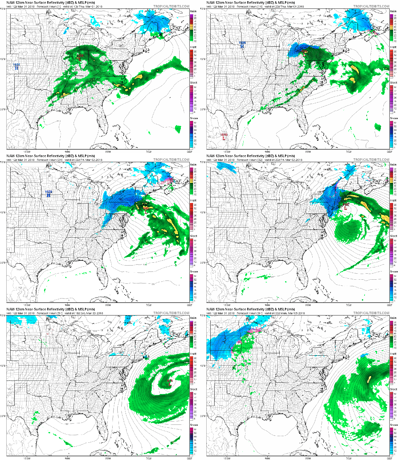
Forecast for the storm based on the NAM model. Loop provided by Tropical Tidbits.
The biggest impacts from this storm will be felt along the coastline. We’ve already got astronomical high tides due to the full moon we had this week. As in the storm churning up the Atlantic and strong winds (more on that in a moment), and you’ve got a recipe for major coastal flooding. Parts of the coastline, especially east-facing shorelines, could see flooding worse than they saw with the storm in early January. Coastal flooding was already observed during the Thursday afternoon high tide without any impacts from the storm. What do you think is going to happen when you have onshore winds of 30-50 mph and 20-40 foot seas? Yeah, nothing good.
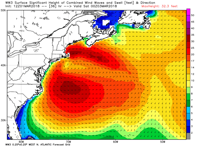
The Wave Watch Model shows a long eastern fetch and 20-30 foot seas slamming into New England Friday evening. Things won’t improve much over the weekend. Image provided by WeatherBell.
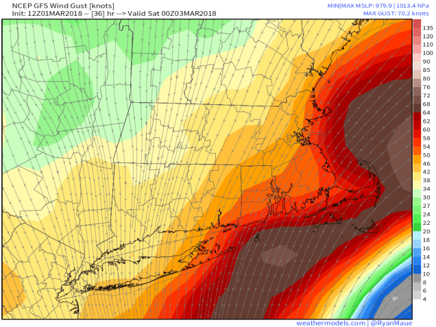
As we mentioned above, strong winds will impact most of the region starting late Thursday night and especially on Friday as the storm begins to intensify in the waters south of New England. High Wind Warnings are already in effect for much of the region. Sustained winds of 25-45 mph with gusts of 60-70 mph are likely, especially near the coastline. Some gusts in excess of hurricane force are possible, especially across Cape Cod. With winds this strong, power outages are likely, so make sure you are prepared for that possibility. Winds may start to diminish a little on Saturday, but as the storm heads southward and grows even larger, it will continue to produce gusty winds across the region right through the weekend.
GFS forecast for wind gusts across the region Friday evening. The red color is 50 knots (58 mph). The brown is hurricane force 64 knots/74 mph). Image provided by Weathermodels.com
In addition to the damaging winds and coastal flooding, heavy rain is also expected across the region. Rain will move in after midnight tonight, and continue for much of the day on Friday, heavy at times. The storm is drawing moisture northward from the Gulf of Mexico and the tropics, and as it moves into the relatively cooler air in place here, it will wring it out across the region. We’re looking at rainfall totals of 1 to 3 inches across the region, with some heavier amounts possible, especially across southeastern Massachusetts and Rhode Island. We’ve already had a wet start to the year, and the ground is close to saturated, so this will likely result in flooding in many areas. Rivers are also running fairly high, especially for this time of year, so river flooding will also become a concern.
GFS forecast for rainfall through Sunday morning. Image provided by Weathermodels.com
Now we get to the tricky part of the forecast, where the greatest uncertainty lies – snowfall. There’s not a lot of cold air in place when the storm moves in, and we don’t have a big high pressure area to the north to help keep any cold air around. However, there is some cold air aloft, and as the system gets cranked up, it may try to tap into that cold air. As we get into some of the heavier bands of precipitation, it may drag some of that cold air down, changing the rain to snow in some areas. This isn’t the type of thing we can predict well in advance, so trying to pinpoint now is futile. However, don’t be surprised if some places change over to snow for a while during the day on Friday. Of course, some of the higher elevations, especially in the Worcester Hills, Monadnocks, and Berkshire, should have enough elevation to have quite a bit of snowfall from this system. It will be the heavy, wet snow that nobody likes either. You know, the type that weights down tries and power lines, making it even easier for them to snap when you get wind gusts of 50 mph or more. The other thing we’re concerned about with snowfall is what happens on the backside of the system. As the storm starts to pull away late Friday, colder air will settle in behind the system. The questions are: 1. How quickly does that cold air move in? and 2. How much precipitation is still around? Right now, we wouldn’t be surprised to see some locations pick up a quick 1-3 inches, possibly even more. There’s also a chance that the colder air moves in too late, and many places see little to no snow at all. The worst-case scenario, and we’re not completely ruling it out yet, is that places change over to snow in a burst of heavy precipitation during the afternoon (like we mentioned above), and never change back. If that were to happen (and the place where that would be possible would be mainly north and west of Boston), then very heavy snowfall amounts would become more likely. For the record, we’re not expecting this, but we are a little wary that it’s at least possible.
Snowfall forecast through Sunday evening from the NAM model. Image provided by Pivotal Weather.
By Monday, high pressure builds in, and everything calms down. We may have another storm to deal with towards the middle of next week, but we’ll worry about that one after we get through this one.
The last few days have been fairly mild around here, and even milder air is coming in for the first half of the upcoming week. So naturally, we’re talking about a snowstorm for tonight.
Low pressure is over the Tennessee Valley at midday, and will quickly move towards the Mid-Atlantic coastline this evening, passing south of New England as it intensifies tonight. Even though the sun is shining now, clouds will quickly move in this afternoon, with snow developing late this evening, around 9pm or so, give or take an hour. Snow will continue overnight, with the possibility for some briefly moderate to heavy snow. Since most of you will be sleeping, this shouldn’t cause too many problems. A change to rain seems likely across parts of Cape Cod and the Islands, possibly even into extreme southeastern Massachusetts.
Forecast for the progression of the storm based on the NAM model. Loops provided by Tropical Tidbits.
Everything winds down near or a little after daybreak. For most of us, a general 3 to 5 inches of snow is expected, with a few spots possibly seeing 6 or 7 inches. Across Cape Cod, where a change to rain is likely, amounts of 1 to 3 inches seem more plausible at this time.
The NAM model is probably closest to our thinking for snowfall totals with this storm. Image provided by WeatherBell.
The snow won’t last too long though. The sun will return Sunday afternoon, with temperatures getting up into the 40s. That will help to quickly melt a lot of what fell overnight. Temperatures will drop back below freezing Sunday night, so things may ice up once again. Use caution if you’re heading out for anything. Even warmer weather is heading in for the start of the week. A warm front will move through on Monday, with some showers preceding the front late in the day. Once the front moves through, unseasonably warm conditions are expected for Tuesday and especially Wednesday. On Tuesday, high temperatures should get into the upper 50s and 60s away from the South Coast. On Wednesday, we could challenge some record highs, with some places possibly making a run at 70 degrees. A cold front will move through late in the day on Wednesday, bringing an end to the warm weather, so enjoy the early taste of Spring while it’s here.
Yes, temperatures could reach or exceed 70 in parts of the region on Wednesday. Image provided by Weathermodels.com
While some of you saw a few snowflakes this morning, there’s a lot more on the way tomorrow, and it’s going to make a mess of your afternoon commute.
GFS forecast for the progression of Wednesday’s storm system. Loop provided by Pivotal Weather.
Low pressure will move out of the Tennessee Valley tonight, and head towards Southern New England. With high pressure over Atlantic Canada, we’ll have some cold air in place to start the day before the clouds quickly fill in by daybreak. When the precipitation moves in around midday, it should start as snow for most of us. However, it’s not going to stay that way.
Warmer air will move in off the Atlantic, quickly changing the snow over to rain across Cape Cod, with little to no accumulation. The changeover will also take place by early to mid-afternoon across southeastern Massachusetts. In these locations, mainly south and east of Interstate 95, accumulations of 1-3 inches are expected before it goes to rain. Farther to the north and west, things get a little more complicated.
Temperatures may not get above freezing north and west of Boston on Wednesday, meaning freezing rain could be a threat for some areas. Image provided by Weathermodels.com
That warmer air may not penetrate much farther inland than I-95 at the surface, but aloft, it probably will. When you’ve got below-freezing air at the surface and above-freezing air aloft, you get freezing rain (or sleet) – something we’ve already dealt with several times this winter. While many of the models are trying to send temperatures into the middle to upper 30s, we’re not buying it. The models almost always try to move warm air in too quickly, so we’re ignoring them. We do expect a change to freezing rain from the I-95 corridor up into the Merrimack Valley during the afternoon and evening, which will limit snowfall accumulations a bit, but also drop a layer of ice on top of everything, potentially making even more of a mess of the afternoon rush hour. For these areas, we’re expecting snowfall totals of 2-4 inches closer to I-95, and 3-6 inches up into the Merrimack Valley, as well as over towards the Seacoast of New Hampshire.
Farther inland, across interior southern New Hampshire, there are fewer questions, but everything isn’t set in stone just yet. Some freezing rain is possible, especially along the MA/NH border (including places like Salem, Nashua, and Manchester), but we’re not completely convinced that it will happen. This is something that really can’t be determined until the storm is ongoing and we see how far northward that warm air penetrates. For now, we’re allowing for this possibility, and conservatively forecasting 4-8 inches of snow. If there is no changeover, and the precipitation stays all snow, then amounts could be a bit higher, with totals of 6-10 inches becoming more common. Once you get north of Manchester, from Concord up into the Lakes Region, snowfall totals of 8-12 inches should be the norm.
While we don’t agree with how it arrives at these numbers, the snowfall totals from the NAM are closest to what we are thinking. Image provided by WeatherBell.
The snow will come down heavy at times during the afternoon across the region, tapering off during the evening. It looks like places that change to freezing rain or rain should go back over to snow at night before everything finally winds down and ends around midnight, give or take an hour. We’re not expecting much additional accumulation once it changes back to snow, but some places could pick up a half an inch to an inch.
Temperatures will stay below freezing all day Thursday, so make sure you get the driveway cleared quickly, or you’ll need some skates to get to your car or mailbox. Image provided by Weathermodels.com
Colder air will settle in behind the storm for Thursday and Friday, so anything that you haven’t cleaned up will freeze solid Thursday morning. Another weak system may bring in some light snow Friday and Friday night, but as of right now, we’re not expecting much accumulation from that system.
So, as you may have heard from the relentless media hype over the past few days, we’ve got a storm headed our way on Thursday. While this will be an extraordinary storm for places like Florida, Georgia, and the Carolinas, up here, we’ve seen a lot worse.
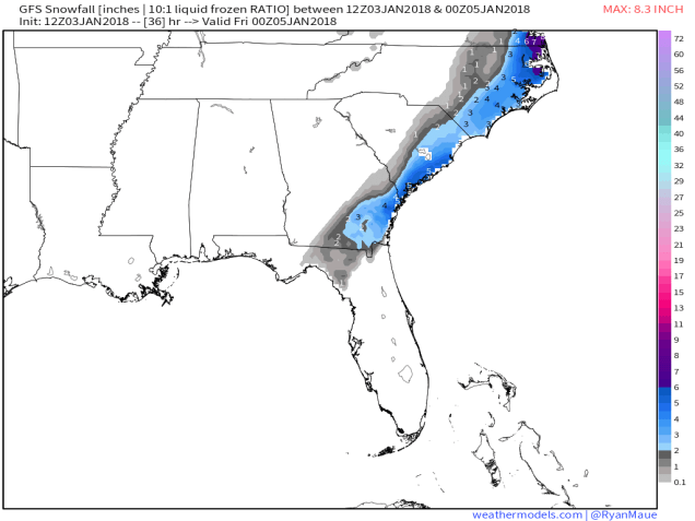
Snowfall accumulations of 2-5 inches from northern Florida into eastern North Carolina? That doesn’t happen too often. Image provided by Weathermodels.com
Snow and sleet have been falling today across portions of northern Florida, Georgia, and South Carolina. Several inches are expected to fall today, especially along the coastline. Given how rarely this happens in some of these locations, it will probably bring the region to a halt, while those of us in the North point and laugh. Don’t worry, our time is coming tomorrow.
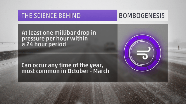
The storm that is producing the snow down South will move up the East Coast later today and Thursday, rapidly intensifying as it does so. You may have heard the terms “bombogenesis” or “weather bomb” used as part of the media hype in the last few days to describe this storm. These are terms that have been around for quite some time. Bombogenesis happens when the lowest pressure of a storm drops more than 24 millibar in a 24 hour period. This happens several times a year with storms off the East Coast. It is nothing out of the ordinary. The reason this storm is getting the attention, aside from the Southern snow, is that the pressures are much lower than a typical winter storm. This will be a strong storm system, but again, we’ve had powerful storms off the East Coast plenty of times before.
Definition of “bombogenesis”. It’s a fairly common occurrence. Image provided by Weather.com
As the storm gets cranked up off the East Coast, it will generate strong winds,, especially along the coast. While we’re looking at wind gusts to 40-50 mph, possibly even higher, things could be a lot worse. We don’t have a large high pressure system to our north (more on that in a minute). If we had a high to our north, increasing the pressure gradient between the storm and the high, winds would be even stronger. The tighter the gradient, the stronger the winds. This is why we can have strong winds with weaker systems, if there is a large high in place to the north.
Along with the winds, coastal residents also have to worry about coastal flooding. Since we’re just past the full moon, tides remain astronomically high. Add in strong onshore winds, and residents along north to northeast facing beaches could experience some coastal flooding around the midday/early afternoon high tide on Thursday. By the time we get to the high tide Thursday night, winds will have shifted into the west or northwest, thus limiting the flooding potential.
Back to the high pressure, or lack thereof, to our north. High pressure has been sitting to our north or northwest all week, which is why we’ve been frigid since before New Year’s. That high has shifted offshore now, allowing somewhat milder air to settle in today. Normally, to get heavy snow, we need that high pressure area to stay to our north or northwest, to lock the cold air into place. With that not the case this time, we’re going to have to deal with a rain/snow line. That seems hard to believe given how cold the past week has been, but it is the case. Water temperatures are still in the lower 40s off our coast, so a strong onshore wind will warm up the lowest layers of the atmosphere enough for a change to rain. This seems like across Cape Cod, but the question becomes, how far inland does that rain/snow line penetrate? The models have varying ideas on this, but a portion of southeastern Massachusetts may see a changeover.
Winter Storm Warning are in effect for virtually the entire East Coast, with Blizzard Warnings (in red) for parts of coastal New England. Image provided by NOAA.
So, we’ve talked about strong winds, coastal flooding, and a rain/snow line. Now, for the only part that most of you are interested in – snow. First, we’ll talk about the timing. Snow should develop from south to north across the region between about 3 and 6am. So, by the time most of you wake up, it will likely be snowing. The snow will end between 7 and 10pm for most of us. The worst of the storm will be between about 9am and 4pm. Snow will be moderate to heavy at times, which combined with strong winds, will create whiteout or blizzard conditions, especially along the coast. If you don’t have to be out tomorrow morning/afternoon, we’d recommend staying where you area. Blizzard warnings have been posted for parts of eastern and southeastern Massachusetts, the NH Seacoast, as well as coastal and Downeast Maine. Remember, the amount of snowfall has absolutely nothing to do with blizzard conditions. You can have a blizzard with no snow falling at all. By definition, you have a blizzard when visibility is 1/4 mile or less due to falling or blowing snow and you have sustained winds or gusts to 35 mph or more for 3 consecutive hours or more.
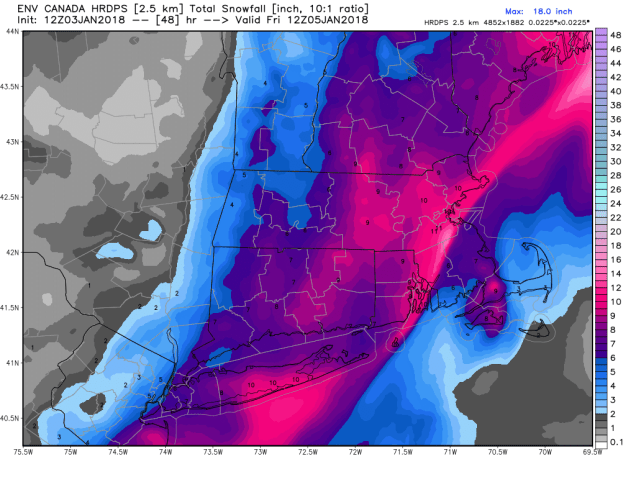
So, how much snow are we looking at? There isn’t really one model that we completely agree with, so we’re going with a blend of the ideas. Because the storm will be moving along fairly quickly, we’re not looking at any blockbuster amounts. The trickiest part is where the rain/snow line sets up. Right now, we’re thinking somewhere close to the Cape Cod Canal. As for amounts, here’s the breakdown:
Outer Cape Cod/Islands: 3-5″
Upper Cape Cod: 4-8″
Southeastern Massachusetts (south and east of I95): 8-14″
Northern RI/Interior Eastern Massachusetts/North Shore: 6-12″
Central Massachusetts/Merrimack Valley/Southern NH/Seacoast: 5-9″
The biggest wild card is Southeastern Massachusetts, especially the closer to Cape Cod you get. The farther the rain/snow line moves inland, the less accumulations will be. This is the area of biggest “bust potential”.
The Canadian HRDPS model is probably closest to our thinking, but not exactly the same. Image provided by WeatherBell.
Once the storm moves by, we’ll slowly clear out on Friday, but gusty northwest to west winds will usher another arctic blast into the region. Saturday may be even colder than any of the days we’ve had over the past week. Especially with fresh snowcover, temperatures will plunge again, with the worst of it on Saturday, when high temperatures likely stay in the single digits. Sub-zero lows are likely across much of the region Saturday morning and especially Sunday morning.
We’ve all heard the opening line of the song more times than we can remember:
“I’m dreaming of a white Christmas, just like the ones I used to know”
Well, this year, it won’t be a dream for a large portion of the region, it’ll be reality. Across southeastern parts of New England, mainly south and east of I-95, – sorry, it’ll be a green Christmas for you, with mostly rain from the system.
Christmas Eve will actually be a fairly nice December day by New England standards. We’ll start the day with some sunshine, but clouds will move in during the afternoon as low pressure moves into the eastern Great Lakes. High temperatures will reach the upper 30s to lower 40s, which is right around normal for late December.
The NAM model shows the progression of the system with the secondary area of low pressure developing off the New Jersey coast and crossing the Outer Cape. Loop provided by Pivotal Weather.
As we head into Sunday night, right around the time Santa is making his rounds, snow will break out across the region, with rain across southeastern Massachusetts and parts of Rhode Island. At the same time, a secondary area of low pressure will start to take shape off the Mid-Atlantic coastline. This low will start to head northeastward, likely passing very close to, or perhaps right over, the Outer Cape, on Christmas morning. As a result of this track, the rain/snow line will likely penetrate as far inland as a Boston-Providence line. Obviously, any variation in track will impact how far inland that warmer air penetrates, which will impact the snowfall forecast. The snow will come down at a steady pace for much of Christmas morning, tapering off and ending by midday as the storm moves into the Gulf of Maine, where it will really get cranked up (more on that in a moment).
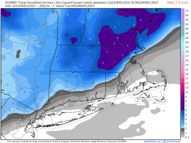
So, how much are we looking at?
If you live south and east of a line that runs from Boston to Providence (roughly Interstate 95), probably just a brief dusting at the tail end of the storm as colder air comes back in as the precipitation is ending.
If you live just west of I-95, from Northern Rhode Island into the Boston area and Metro West, 1-3 inches.
Anywhere outside of there, especially the I-495 belt from Central Massachusetts into the Merrimack Valley, North Shore, Southern New Hampshire, and the New Hampshire Seacoast, 3-6 inches, with some isolated spots picking up as much as 8 inches.
The ECMWF is closest to our thinking for snowfall with the Christmas storm system. Image provided by Weather.us
As the system moves into the Gulf of Maine Monday night into Tuesday, gusty winds are likely behind it, ushering much colder air into the region. Low temperatures Tuesday morning will drop into the middle teens to lower 20s, but wind chills will be in the single numbers and even below zero in spots Tuesday morning. This is also bad news for places that had mainly rain during the day, as it will ice everything up in the evening, creating some slippery travel. This bitterly cold air looks to remain in place for much of the week as a large area of high pressure builds in. We’ll get into more detail in our Weekly Outlook Monday morning, but this high pressure area is good news, as it may help to deflect a potential storm later in the week off to our south (much to the chagrin of the Facebook Forecasters who were already trumpeting about a potential snowstorm a week in advance because some of the models showed it).















 Storm HQ