Back in our Weekly Outlook on Monday, we warned you that even though Meteorological Winter ends on February 28, that March can still be a wintry month. Well, today is March 1, and we’re looking at two snowstorms in the first four days of the month.
You can see that this is a fairly fast-moving storm. In by daybreak Saturday, out before dinnertime. Loop provided by Tropical Tidbits.
Technically, there’s actually 3 storms, as the first one is passing south of the region this morning. It brought in some clouds, and a few stray flakes across southeastern Massachusetts, but otherwise, had little impact on us. The first storm we need to pay attention to is moving across the central Appalachians this afternoon. It will move off the Mid-Atlantic coast tonight, then pass south of New England on Saturday. A few days ago, it looked like this storm would pass harmlessly to our south while a a system to the north brought in some snow or rain later on Saturday. Well, this storm became the more dominant of the two, and will pass closer to us than originally thought.
Snow will develop Saturday morning, maybe before daybreak south of Boston. It may even start as some sleet or rain across Cape Cod before changing to snow It will snow steadily during the morning hours, and then taper off and end during the afternoon, possibly lingering along the coast until evening. Despite the hype from some of the media, this will not be a big storm. Oh sure, it’ll be disruptive to your Saturday morning/afternoon plans, but it’s not a major storm.
So, the big question – how much?
Central NH/Southern ME (Concord/Portland) – Less than 1″ Southern NH/Seacoast/Cape Cod (Manchester/Nashua/Portsmouth) – 1-2″ Merrimack Valley – 2-4″ Metro Boston/MetroWest/Southeastern MA/ Rhode Island – 3-6″
Would be we shocked if a few spots, especially south of Boston, pick up 7 or 8 inches? Nope, not at all. This won’t be the fluffy snow we had a few days ago, so it won’t pile up as quickly.
We’ve stuck with the high-resolution NAM for most of the winter and it’s served us well, so we’re going to do it again. Image provided by Weathermodels.com
OK, so the snow ends Saturday afternoon/evening, and we’re all set, right? Nope – the next storm, follows fairly quickly for Sunday night and Monday. This one looks a little strong, and will pass a little closer. This will allow for the rain/snow line to penetrate a little farther into southeastern Massachusetts. However, with it being a stronger storm, it will have more moisture to work with, and that means more snow. There’s still many details that need to be worked out, and some things will depend on what the first storm does, so we’re not going to go into too much detail yet. We’ll have another blog post Sunday morning focused on that storm. But, there are several models showing the potential for up to, or even more than a foot of snow in spots from that storm.
The NAM model indicates that we could get a pretty good wallop early Monday. We’ll see if things stay that way over the next day or two. Image provided by Pivotal Weather.
After that storm goes by, it looks cold and dry for a few days. But let’s take it one storm at a time for now. Look for an update from us Sunday morning.
While you’re enjoying a sunny Sunday, we’ve got some snow on the way tonight into Monday. It won’t be a lot, but it’ll probably make your morning drive to work into a large headache, especially south of Boston.
Low pressure will move out of the Ohio and Tennessee Valleys today and head east-northeastward, passing south of New England Monday morning. For once this season, we have enough cold air in place and a favorable storm track that we’ll be talking about all snow with this system, except possibly across parts of Cape Cod and the Islands. Since this is a fairly weak storm, we’re not talking about a lot of snow to begin with, and with it passing well to the south, the amounts will taper off quickly, the farther north you go.
The high resolution NAM model has a pretty good handle on how this storm will go, on our opinion. Loop provided by Tropical Tidbits.
The snow will develop late this evening from west to east, roughly in the 10pm-midnight time frame. It will continue through the overnight hours, and may even be briefly moderate to heavy south of Boston. While the steadiest snow looks to end during the morning hours on Monday, occasional light snow and snow showers will continue off an on during the afternoon, especially along the coastline. Everything should be done by evening.
So, how much are we looking at? Southern NH/Southern ME: 1″ or less Merrimack Valley: 1-2″ North Shore/Metro West: 1-3″ I-95 Corridor (Boston/Providence): 2-4″ Southeastern Mass/Southern RI: 3-6″, possibly a little more across Cape Cod
We’ve stuck with the high-resolution NAM for much of the winter, and it’s done pretty good, so we see no reason to go against it now. Image provided by WeatherBell.
Another storm may bring in more snow towards Wednesday, but we’ll have more details on that in our Weekly Outlook early Monday.
In our forecast yesterday, we told you that some of the biggest questions were the track of the storm system and related to that, how far north the change to sleet/freezing rain would take place. Well, we’ve got some more clarity on that now.
Some of you are already seeing some snow falling this afternoon, but this is not related to the storm. Some ocean-effect snow has pushed into Cape Cod and Plymouth County, and will continue to push inland this afternoon. This will be light, with less than an inch in most spots. The steadier snow will move in late this afternoon and evening from the west, reaching southern NH and the Merrimack Valley first, then the rest of Eastern Massachusetts and Rhode Island. It’s after midnight where the changes start to take place.
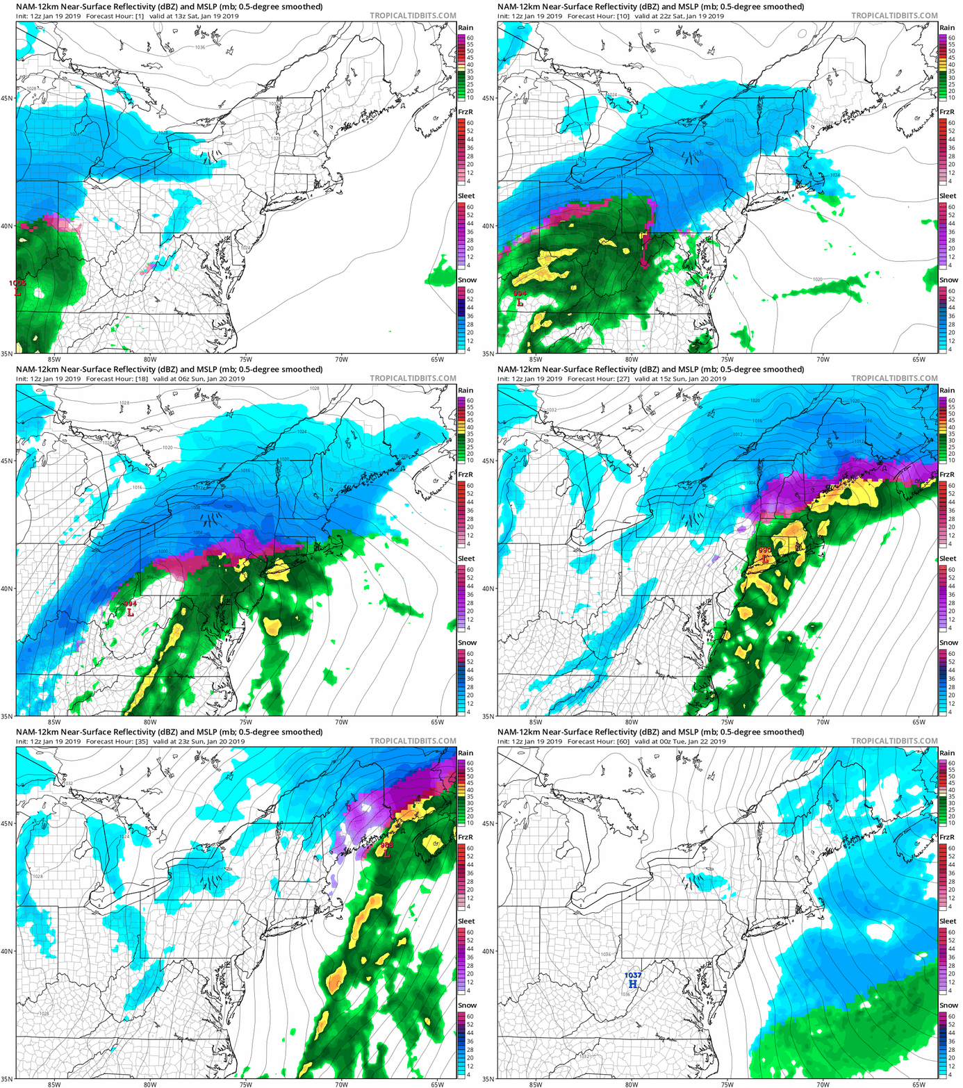
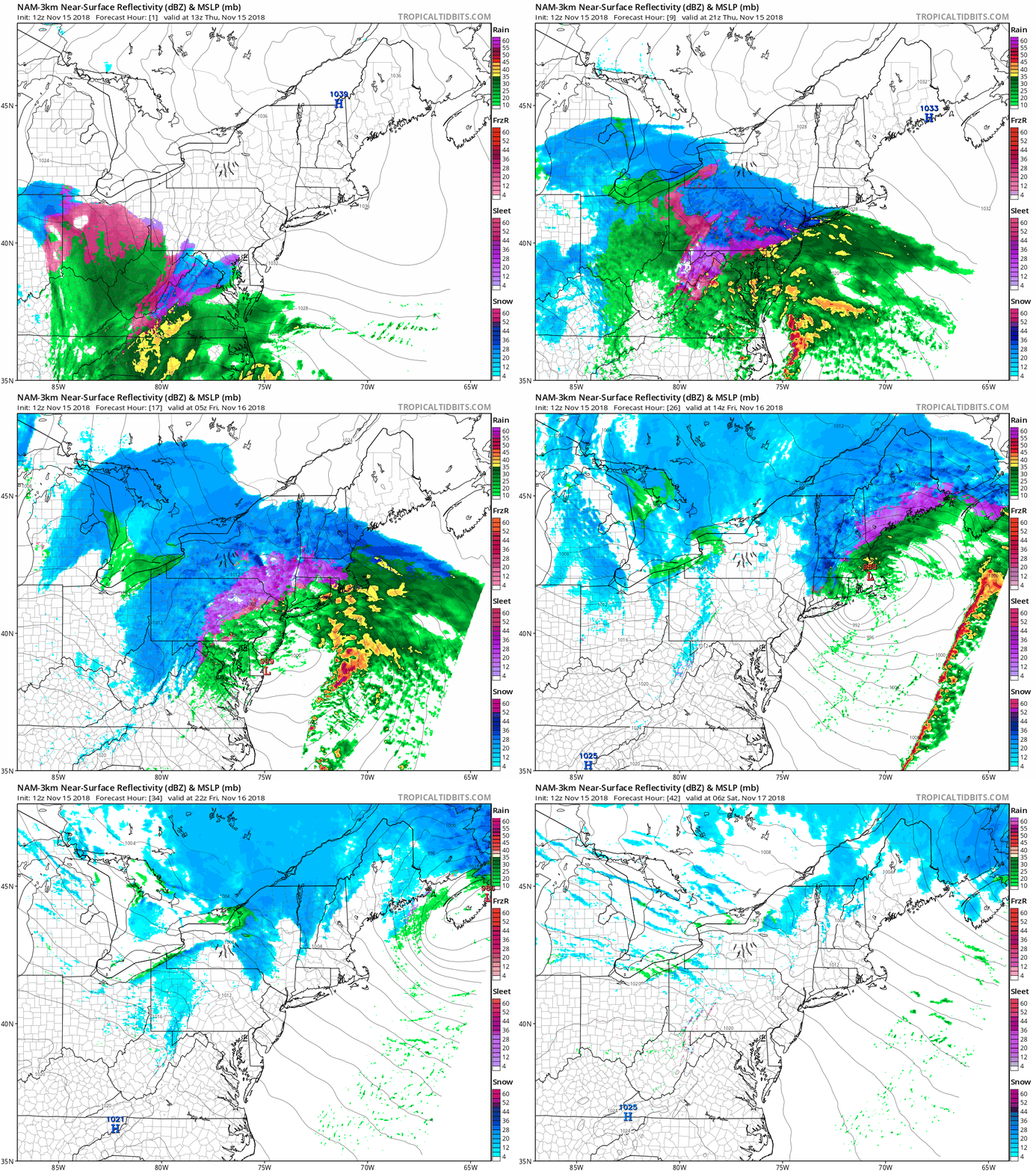
The NAM model shows the progression of the storm with the changeover to sleet. freezing rain, and plain rain gradually spreading northward early Sunday. Loop provided by Tropical Tidbits.
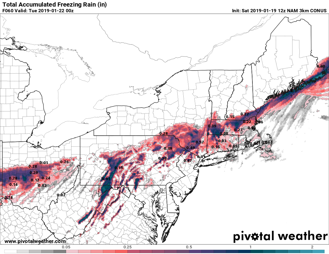
The storm system looks like it will track a bit farther north, passing very close to Boston on Sunday. This will not only allow milder air to move into most of southeastern Massachusetts, but the milder air aloft will also move much farther north than we had anticipated yesterday. Snow will fall heavy at times overnight, especially north of the Mass Pike, but as the warmer air starts to move in, we’ll see a change to sleet and eventually freezing rain move into the South Coast towards Midnight. A change to plain rain is likely before daybreak across southern Rhode Island and southeastern Massachusetts, as temperatures may break into the 40s Sunday morning. Some of the rain could be heavy, which may wash away most of the snow that does fall. Farther north, snow will gradually change to sleet and freezing rain north and west of Boston towards daybreak, with the changeover likely getting into southern NH as well. This will significantly cut down on snow amounts, but could make travel quite hazardous if there’s enough freezing rain.
The NAM model is forecasting up to 1/4 inch of freezing rain in parts of southern NH and the Merrimack Valley. Image provided by Pivotal Weather.
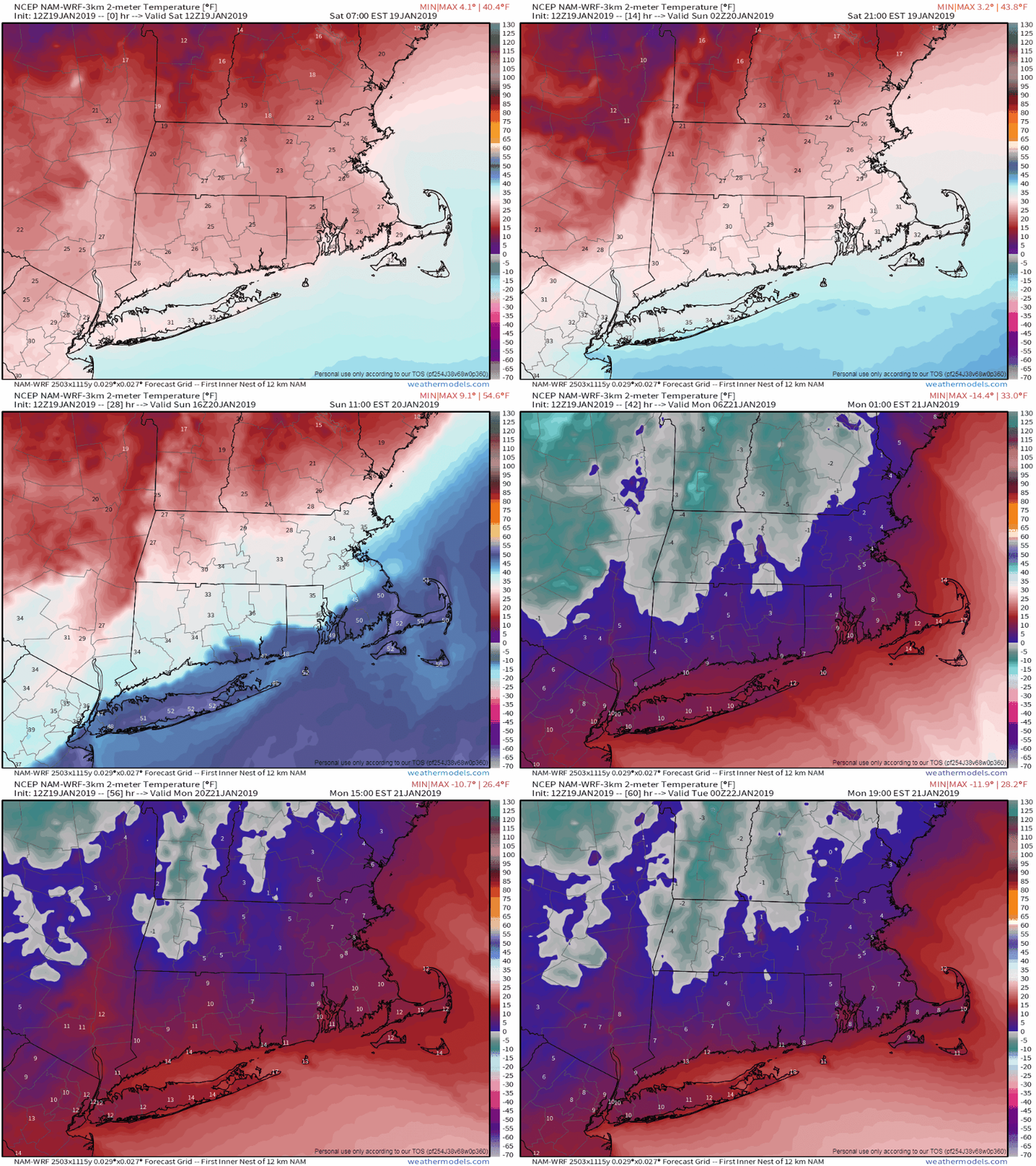
By midday, the storm passes by and moves offshore, with winds shifting into the north. This will bring much colder air back in, and rather quickly. Temperatures may get close to or a little above freezing during the morning from southern NH into the Merrimack Valley and the northern and western suburbs of Boston, but by afternoon they’ll quickly drop into the 20s during the afternoon and teens by evening. That will result in a flash freeze, and any untreated surfaces will quickly freeze up, resulting in very hazardous travel. It will also mean that anything you haven’t cleaned off of your car, driveway, sidewalk, etc. will quickly turn into cement. The bitterly cold air will continue to flow in, and temperatures on Monday may struggle to reach the lower teens, with wind chills below zero thanks to gusty northwest winds. These gusty winds may also produce some ocean effect snow across parts of Cape Cod, especially the Outer Cape.
The High Resolution NAM model shows the rollercaster that our temperatures will be on over the next couple of days. Loop provided by Weathermodels.com
So, how much snow are we expecting now? Here’s our current thinking:
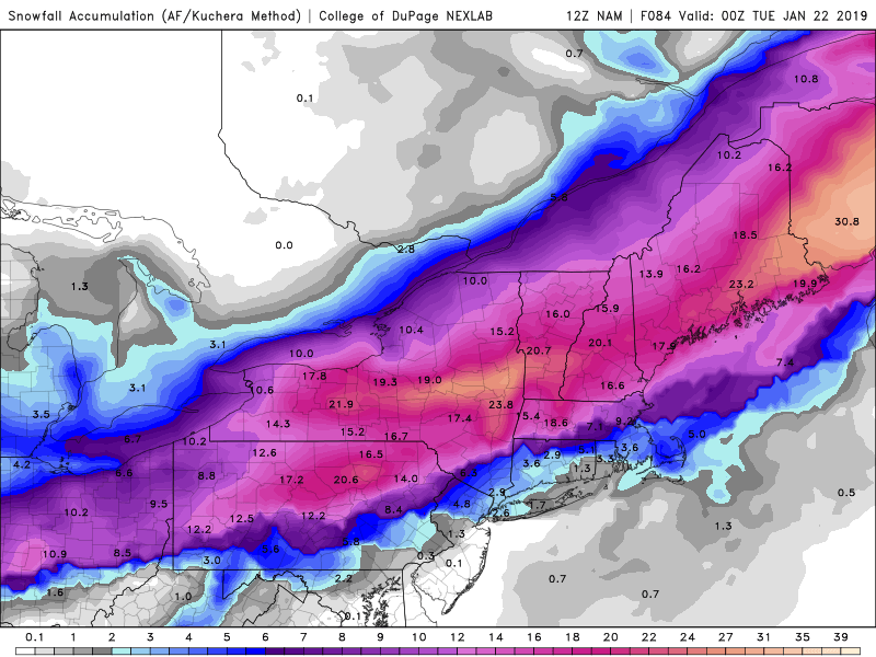
Cape Cod/South Coast: 1-3 inches Southeastern Massachusetts/I-95 corridor: 2-4 inches MetroWest/North Shore: 3-5 inches Merrimack Valley/NH Seacoast: 3-6 inches Southern NH: 4-7 inches Central NH/Southern Maine: 8-14 inches, with higher amounts the farther north you go.
While there isn’t any one model that matches our current thoughts on accumulations, the High Resolution NAM model is closest to our current thinking. Image provided by the College of DuPage.
Temperatures will slowly start to moderate on Tuesday, then another system may move in on Wednesday, but this one, believe it or not, may be mostly rain. We’ll see how that evolves over the next few days.
We haven’t had a decent-sized snowstorm around here since late November. Well, that is about to end, much to the dismay of most of you. We’ve got several different concerns with this system, so we’ll try and touch on all of them.
Winter Storm Watches and Warnings are in effect for most of the Northeast with a Coastal Flood Watch for parts of the Massachusetts coastline. Image provided by Pivotal Weather.
We’ll start with what’s going on now. High pressure is building into Quebec, and this will bring cold air into the region. Tonight will be chilly, with lows in the teens, maybe even some single numbers. Meanwhile, low pressure is moving out of the Southern Plains. This low will move towards the Appalachians on Saturday, then off the Mid-Atlantic coastline Saturday night. This brings us to forecast problem number 1. Where does the low track from there? This is a critical point, as it will help determine what type of precipitation falls across the area. Some models keep the storm offshore, south of the Cape and Islands, while others bring it right across southeastern New England. We’re thinking it tracks pretty close to the Islands, but stays just to the south. By Sunday, it moves into the Gulf of Maine, and takes all of the precipitation away.
As for the timing of that precipitation, there’s not much disagreement among the models. Snow should move in during the evening hours (7-9pm) from west to east, and end during the afternoon (3-5pm) on Sunday, except across Cape Cod and parts of southeastern Massachusetts, where it may linger into Sunday night. The heaviest precipitation will likely fall between about 11pm Saturday and 8am Sunday, so if you don’t have to be out then, we’d recommend that you stay where you are.
The High-Resolution NAM model shows the progression of the precipitation across the region. Blue is snow, orange is sleet, purple is freezing rain, and green/yellow is rain. Loop provided by Weathermodels.com
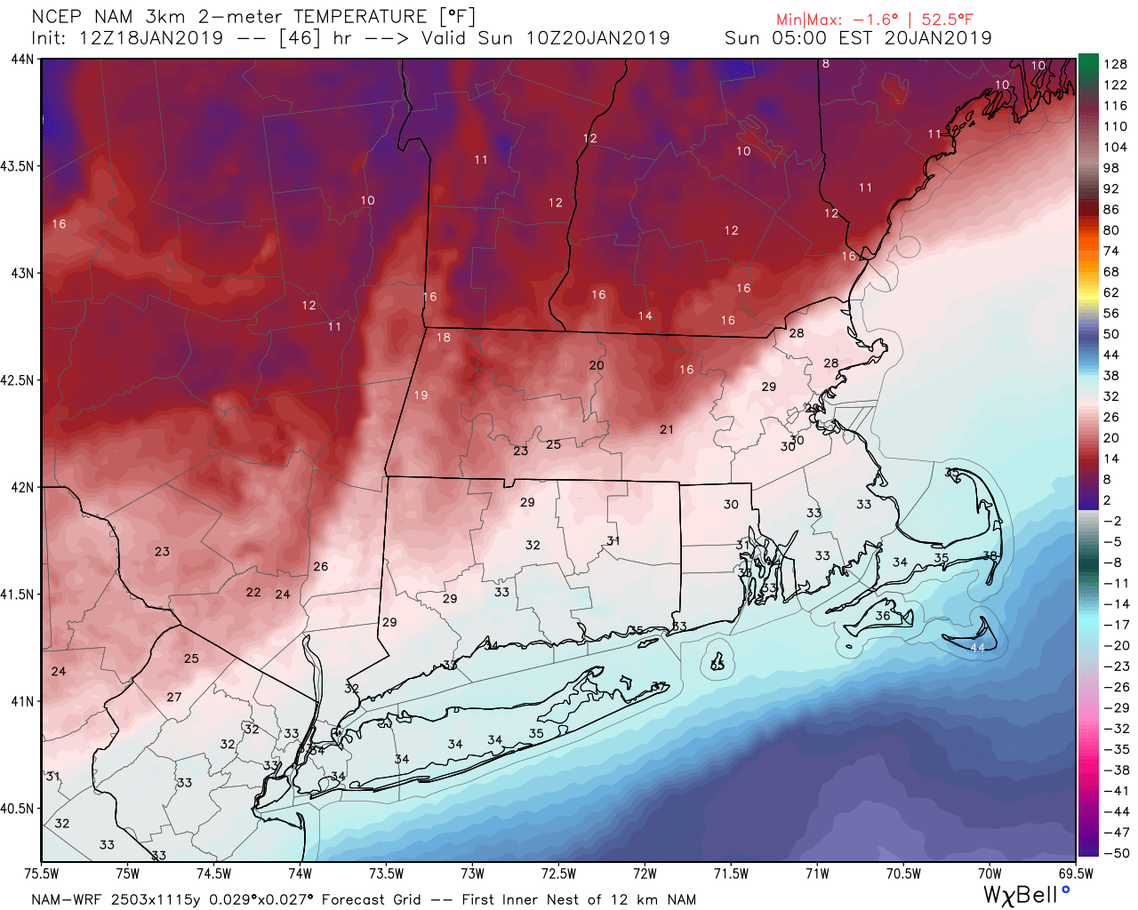
What type of precipitation is going to fall? Well, that is a BIG question, that is still in doubt for a large portion of the region. It should start as snow for everyone. It will likely change to rain across Cape Cod and the South Coast, and parts of southeastern Massachusetts. In between? That’s where things get really complicated. As we usually see during storms, we’re going to have a “coastal front” set up. Basically, the milder air from the ocean will push inland a bit. If you are south and east of this coastal front, temperatures will be near or just above freezing. If you are on the other side of the front, temperatures will be in the teens. Eventually, this front will collapse to the coast on Sunday, bringing the cold air in everywhere (more on that later). But the surface is only part of the equation. Warmer air will also move in aloft. How far inland it moves is something that that models disagree on right now. With warm air aloft and cold air at the surface, the precipitation will change to sleet or freezing rain, depending on how thick the layer of warm air is above the surface. Obviously, this will have a significant impact on snowfall amounts. Everything should go back to all snow Sunday afternoon as the coastal front collapses toward the coastline.
The high-resolution NAM model shows a well-defined coastal front setting up in the Merrimack Valley and the I-495 belt Sunday morning. Image provided by WeatherBell.
We’ve got more concerns than just what falls from the sky though. The full moon is Sunday night, which means that tides will be astronomically high. That is usually enough for some minor coastal flooding in a few spots. However, when you add in east to northeast winds of 15-25 mph and gusts to 40-50 mph (or more), then you get coastal flooding in a much wider area, possibly even some moderate flooding in the more vulnerable locations. This is mainly a concern for the high tide that occurs Sunday morning. The winds will also be a concern inland, as it will create blowing and drifting snow, making driving even more hazardous.
We mentioned earlier that the coastal front would collapse to the coastline during the afternoon, bringing cold air back in everywhere. As that cold air comes rushing in, we expect everything to quickly freeze up Sunday afternoon and evening. This will create black ice on the roads, but more importantly, any snow still on your driveway, cars, roads, etc, will quickly turn into cement. You’ll want to get outside and quickly clear everything off, because the longer you wait, the more difficult it will become. Temperatures will continue to drop Sunday night, and as high pressure builds in, skies will clear out, which may allow for viewing of the total lunar eclipse Sunday night. On Monday, temperatures won’t rise that much, with many places likely staying in the single numbers or lower teens. It will still be breezy, so wind chills may stay below zero all day long. Temperatures will start to moderate on Tuesday, but longer-range indications are that we are in a colder (and stormier) pattern now, so winter has finally arrived.
This is the forecast high temperatures for Monday based on the GFS model. It’s going to be cold. Image provided by Weathermodels.com
OK, finally, the part you’ve all been wondering – how much are we getting? As we’ve said, the amount of sleet and freezing rain will have a significant impact on snow accumulations, so we’re going to keep our ranges somewhat wide for now, and if need be, we’ll put out an update on Saturday.
Cape Cod: 2-4″ Southeastern Massachusetts/Southern Rhode Island: 3-6″ I-95 corridor (including Boston and Providence): 4-8″ MetroWest/North Shore: 6-12″ Merrimack Valley/NH Seacoast: 8-14″ Southern NH/Southern ME (Nashua/Manchester/Portland): 10-16″ Central NH (Concord): 12-18″
The NAM model is probably closest to our thinking right now, though some of these numbers may be a bit higher than our thoughts. Image provided by the College of DuPage.
If time allows, and/or there is a significant change in the forecast, we’ll update this on Saturday.
The hype train is already leaving the station – that’s right, there’s a “chance” for some snow next weekend. Since we haven’t had much snow yet this winter (haven’t heard many complaints about that), much of the media is going nuts, salivating at the prospect of a week of trying to outdo each other in the stupidity department. You’ll find none of that here, so let’s just get to the forecast.
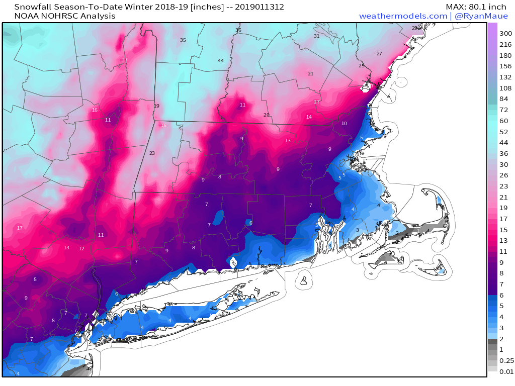
We really haven’t that much snowfall so far this winter. Will that change? We’ll see. Image provided by Weathermodels.com
We will start the week off with a little bit of snow for some of you, mainly along the coast and south of Boston. Northeast winds blowing over the still relatively mild Atlantic will produce a little ocean-effect snow across Cape Cod and parts of Plymouth County. We’re not talking about much more than a dusting, though a few localized spots could see an inch or even two. Otherwise, high pressure keeps us dry and seasonably cold right through Thursday.
On Friday, low pressure will approach from the west. We’ll see some light snow or rain with this system, with the best chance for any snow mainly north of the Mass Pike. Obviously, this will depend on exact track of the system, but temperatures won’t be that cold, the system won’t be that strong, and it’ll be moving along fairly quickly. So, not that big of a deal. High pressure builds in late Friday into Saturday while another storm system moves into the Southeast. This brings us to Sunday.
A little bit of snow is expected on Friday, mainly north and west of Boston. Image provided by Pivotal Weather.
Many of the forecast models are showing the potential for this system to head up the East Coast Saturday night into Sunday while high pressure moves into Quebec. This is the setup for a classic Nor’easter, and most of the models are showing this. They mainly show that Sunday will feature heavy snow, strong winds, and likely some coastal flooding due to the astronomical high tides. Some of the models are showing snowfall amounts in feet, not inches. Of course, many in the media have seen this, and are gleefully hyping it up already, while throwing in words like “possible” as an afterthought, after showing maps with model snowfall amounts, meaning that nobody hears the word “possible”. Here’s the thing, this is still 6-7 days away, and as we’ve mentioned more than a few times, the models have been absolutely horrible beyond about 2-3 days. So, why would we suddenly take a 7-day forecast and believe it now? Remember, the storm that hit Washington, DC yesterday was forecast by the models a week ago to bury New England instead. In short, yes, there is a “chance” for a storm next weekend, but we’re not buying what the models are selling just yet. If they are still forecasting this as we get towards Thursday or Friday, then maybe we’ll jump on board and have a blog post about it. Until then? Nope, not gonna do it.
One thing we are certain about for next Sunday is that the Patriots season will continue, with a trip to the Super Bowl on the line against the Kansas City Chiefs. Right now, it looks like we’ll have clear skies for the game which kicks off at 6:40pm EST on Sunday, with a game-time temperature around 10 degrees. Obviously, this is subject to change for the reasons we outlined above in reference to the models. As for the game itself, the Patriots will make a 3rd straight trip to the Super Bowl after they knock off the Chefs Chiefs by a score of 34-31.
Monday: Morning flurries along the coast south of Boston, otherwise becoming partly to mostly sunny. High 27-34.
Monday night: Clear to partly cloudy. Low 15-22.
Tuesday: Sunshine and a few clouds. High 30-37.
Tuesday night: Clear to partly cloudy. Low 18-25.
Wednesday: Partly sunny. High 34-41.
Thursday: Sunshine gives way to increasing clouds. High 23-30.
Friday: Cloudy with a chance for snow north of the Mass Pike, rain or snow south of the Pike. High 33-40.
Saturday: Some early sun, otherwise partly to mostly cloudy. High 24-31.
Sunday: Cloudy and windy with a chance of snow. Highs ranging from the teens north and west of Boston, to the lower 30s across southeastern Massachusetts.
Remember last week when we hinted that First Night could be really cold? Well, it seems as though we were wr….wro….wro….we were a little off.
It is NOT going to be a fun First Night in the Dakotas. Image provided by Weathermodels.com
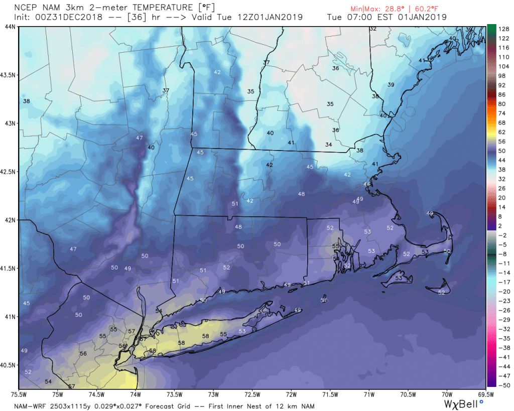
First Night is actually going to be bitterly cold, if you’re planning on spending it in Fargo, where wind chills will be 25 to 35 degrees below zero when the clock strikes midnight. Around here? It’ll be a tad milder. Low pressure will move from the Great Lakes into northern New England later today and tonight. Precipitation will move in this evening, and it will likely still be cold enough for some snow, sleet, or freezing rain from the Merrimack Valley northward, at least at the start. Elsewhere, just some rain is expected. Milder air will move in aloft, and eventually at the surface too, changing the precipitation to rain everywhere overnight. That warm air may take its time moving in, especially from the Merrimack Valley into southern New Hampshire, but New Years Morning will likely be quite mild across much of the area. Don’t get used to it, as a cold front moves through during the morning, with windy and colder conditions likely for the afternoon.
The NAM model shows cold air stubbornly hanging around in southern NH and the Merrimack Valley Tuesday morning, while everywhere else turns milder. Image provided by WeatherBell.
Tuesday afternoon is also when the Winter Classic takes places, featuring two of the absolute best sweaters in the NHL (and two of our favorite teams here at StormHQ) – the Boston Bruins and the Chicago Blackhawks. We’ll refrain from comment about the fact that it’s taking place at the home of the Angry Leprechauns – Notre Lame, er, Dame, or that outdoor hockey games are much better on TV than in person (trust us, we’ve experienced it), but for the game itself, it should be cloudy with temperatures in the middle 30s, which is pretty much perfect for outdoor hockey.
We’re not fans of outdoor hockey games, but we are fans of the Bruins and the Blackhawks. The weather will cooperate, so let’s hope for a great game (and a Bruins victory). Image provided by the National Hockey League.
As we head deeper into 2019, things get quieter (and colder) around here for a few days. High pressure builds in, and we’ll have generally dry and cool conditions for much of the remainder of the week, as we remain in a split jet-stream pattern. Basically, we’ve got a northern stream keeping some storms across southern Canada and to our north, and a southern stream keeping the warmer, juicier storms to our south. This will be the case on Friday when it looks like a southern stream storm will come along and give us some rain, while the northern stream remains locked up in Canada. If you don’t like snowstorms, then you want this pattern to continue. Why? Because if the streams cross, to quote Dr. Egon Spengler, “It would be bad.” That’s usually how we end up with some of our bigger snowstorms in the winter. As the storm moves by, colder air will work in behind it, with the rain possibly changing over to snow before ending on Saturday. High pressure then returns for next Sunday.
New Years Eve: Becoming mostly cloudy. High 37-44.
Monday Night: Cloudy and becoming breezy with rain developing, starting as some snow or a wintry mix from the Merrimack Valley into southern New Hampshire. Rain ends towards daybreak. Low 32-39 during the evening, then temperatures will hold steady or slowly rise overnight.
New Years Day: A lingering shower early, then becoming partly to mostly sunny, windy, and colder. High 49-56 in the morning then temperatures quickly drop through the 40s during the afternoon.
Tuesday night: Clear to partly cloudy. Low 18-25.
Wednesday: Mostly sunny. High 27-34.
Thursday: Partly sunny, slight chance for a snow or rain shower. High 35-42.
Friday: Cloudy with rain developing in the afternoon, continuing at night. High 38-45.
Saturday: Cloudy and breezy with rain, possibly mixing with or changing to snow before ending late in the day. High 34-41.
Sunday: A mix of sun and clouds, breezy. High 36-43.
You’ve been dreading this day for months. Snow is in the forecast. Winter has arrived, and there’s not much you can do about it.
Snow will develop this evening, but change to rain across most of the region by daybreak. Loop provided by Tropical Tidbits.
High pressure is moving out of the region at midday after providing us with a chilly morning. Low pressure is starting to move northward from the Carolinas, and the clouds have already streamed in ahead of it. With that cold air still in place, as the moisture from the storm moves in, we’ll have snow developing late this afternoon and this evening across the area. Right along the coast, the precipitation may start off as rain, as water temperatures are still relatively warm.
As winds become easterly across the region, that warmer air will gradually push farther inland both at the surface and aloft. As a result, we’ll see the snow change to sleet, freezing rain, and eventually rain from south to north overnight. How quickly that warmer air moves in, especially aloft, will determine how much snow falls. More sleet and freezing rain would cut down on snow amounts, but also created some more hazardous driving conditions overnight, especially north and west of Boston.
By morning, we should be all rain for much of the region, though from central New Hampshire northward, it will still be fairly wintry. The rain may be heavy at times through the morning, which will probably wash away most of the snow that falls this evening. So, you probably won’t need the shovels or the snow brushes when you head out to work or school in the morning. Everything winds down around midday, then gusty northwest winds behind the storm help clear things out late in the day.
So, how much can we expect? Here’s our current thinking:
MA/RI coast/Cape Cod: Less than 1″
Interior E Mass/RI: 1-2″
Merrimack Valley/NH Seacoast: 2-4″
Interior Southern NH (Manchester/Concord): 2-5″
Central NH: 4-7″
The NAM model is closest to our thinking for the current storm, perhaps a little too high with snowfall across eastern Massachusetts. Image provided by Pivotal Weather.
Another weak system will come through late Sunday night into Monday morning. This will produce some snow or rain showers, but won’t be a big deal at all. Winter’s here, so you’d better get used to it.
For the third year in a row, the “M” storm in the Atlantic is prepared to wreak havoc on a populated area, but Michael isn’t the only headline maker in the weather at the moment.
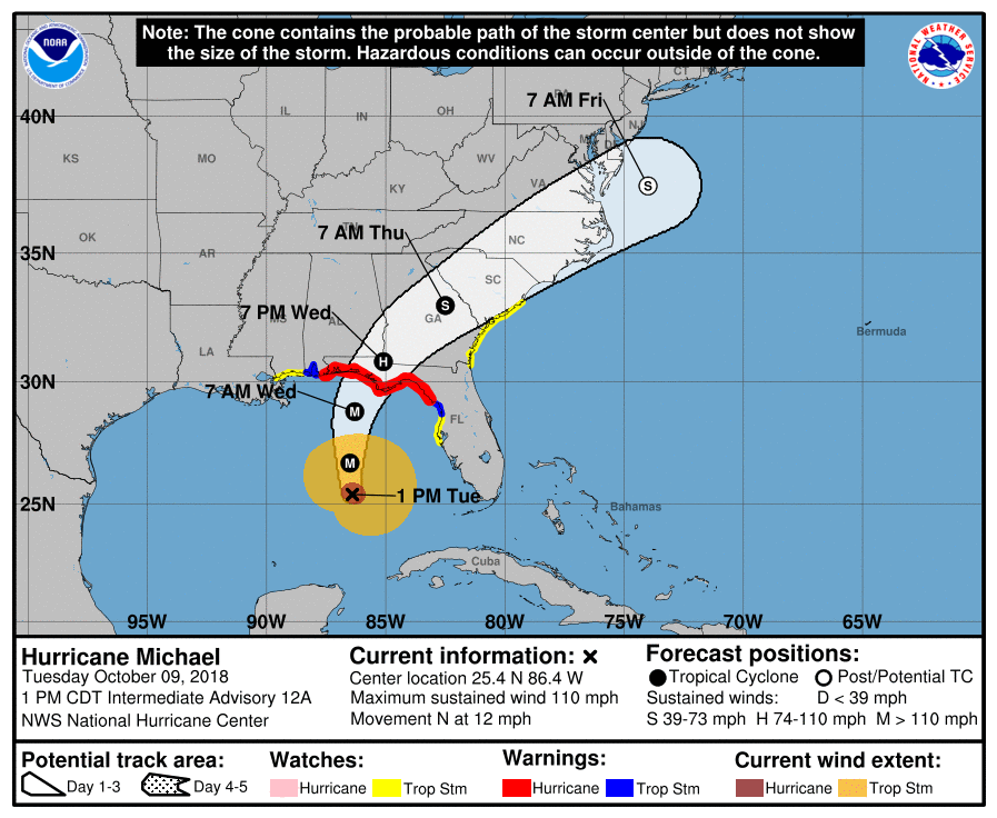
Hurricane Michael isn’t the only storm in the news, but it is the biggest threat at the moment. As of early Tuesday afternoon, Michael was centered about 335 miles south of Panama City, Florida, moving toward the north at 12 mph. Maximum sustained winds are near 110 mph, making Michael a Category 2 Hurricane. Additional strengthening is expected over the next 12-18 hours as the storm moves over the warm waters of the eastern Gulf of Mexico. Hurricane and Storm Surge Warnings are in effect for the Florida Panhandle and the Big Bend area of Florida, with Tropical Storm Warnings and Watches surrounding the Hurricane Warnings. Tropical Storm Watches are also in effect for the Atlantic coast from northeastern Florida into South Carolina.
Michael is going to pack quite a wallop when it slams into the Florida Panhandle Wednesday afternoon. Image provided by the National Hurricane Center.
Michael is expected to make landfall in the Florida Panhandle Wednesday afternoon, likely as a Category 3 storm. Strong winds, torrential rainfall, storm surge, and some tornadoes are all possible with this storm. Unlike Florence, which hung around the Carolinas for days and dumped incredible amounts of rainfall on the region, Michael is expected to keep moving at a steady pace, emerging off the Mid-Atlantic coast by Friday morning. Rainfall totals of 5-10 inches are still expected in parts of the region, which will produce flooding in some areas, especially in Carolinas, where many areas are still recovering from Florence. Right along the coast, a storm surge of 6-12 feet is possible, especially in the Big Bend area of Florida. Fortunately, this area is not heavily populated, but for the residents that do live in this area, storm surge flooding is a significant threat.
Once it moves back into the Atlantic early Friday, it should pass well south of our area. The northern edge of the rainfall from the system could reach the South Coast, but the bulk of the heavy rain should remain well to the south.
This is the 3rd year in a row that the “M” storm is expected to result in significant damage to a populated area. In 2014, Category 5 Hurricane Matthew left a path of death and destruction across parts of Haiti, Cuba, the Bahamas, and eventually parts of the southeastern United States. Last year, Category 5 Hurricane Maria devastated the northeastern Caribbean, including Puerto Rico and the US Virgin Islands. While Michael is not expected to become a Category 5 storm, it is still expected to result in significant damage to parts of Florida and the Southeast.
Tropical Storm Leslie has been around for near 2 weeks and still looks rather healthy. Loop provided by NOAA.
Meanwhile, in the eastern Atlantic, Tropical Storm Leslie refuses to go away. As of midday Tuesday, Leslie was centered a little more than 1000 miles west-southwest of the Azores, moving toward the south-southeast at 13 mph. Maximum sustained winds are near 65 mph. The forecast for Leslie calls for a turn more toward the east over the next few days while it strengthens back into a hurricane. Leslie is expected to remain over open waters for the next few days, and could become an extratropical storm this weekend while continuing on a general easterly track.
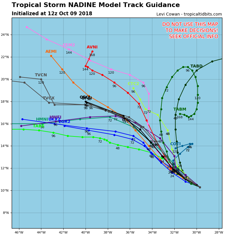
Nadine is a fish storm. Nothing to worry about here. Image provided by Tropical Tidbits.
To the south, Tropical Storm Nadine as formed nearly 500 miles southwest of the Cabo Verde Islands. Nadine has maximum sustained winds near 40 mph, and is moving toward the west-northwest at 9 mph. Nadine is expected to remain fairly weak over open waters for the next several days while turning more toward the northwest. As it moves over colder water late this week and this weekend, it should weaken and eventually dissipate.
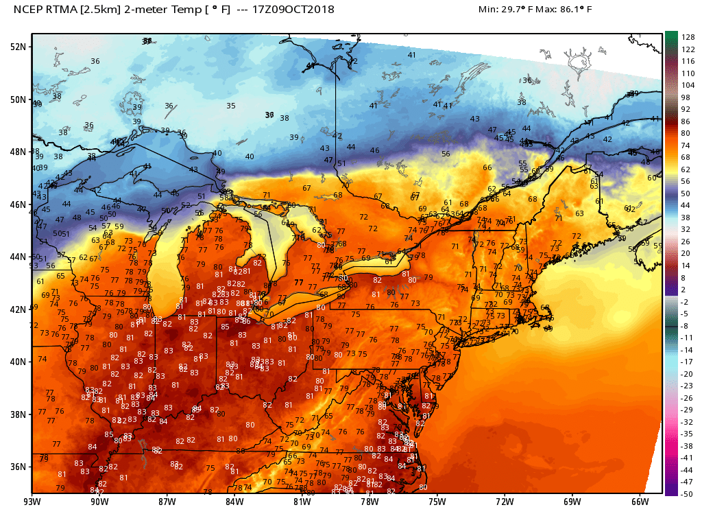
What month is it again? 70s and 80s early in the afternoon on October 9th? Image provided by WeatherBell.
Back in the United States, unseasonably warm conditions remain in place across much of the eastern half of the nation. Temperatures are in the 70s and 80s across much of the region, which is 15 to 25 degrees above normal. A strong frontal system is located in the Plains states this afternoon, separating the warm air in the East, from much cooler weather behind it in the Plains and the Rockies. Right along this front, which hasn’t moved much for the past 24 hours, severe weather and heavy rainfall are common this afternoon.
That’s snow in Colorado, and heavy rain along with severe weather from Texas into the Central Plains this afternoon. Loop provided by WeatherTAP.
Several tornadoes have been reported already today, including a few in the Oklahoma City area, and more are expected later today and tonight. Heavy rainfall is also expected from Texas into the Central Plains and parts of the Upper Midwest. Rainfall totals of 1-3 inches and locally heavier may produce flash flooding in some areas. Flash flood watches are in effect for much of the region.
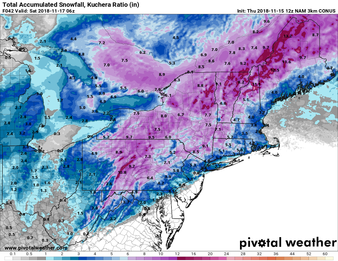
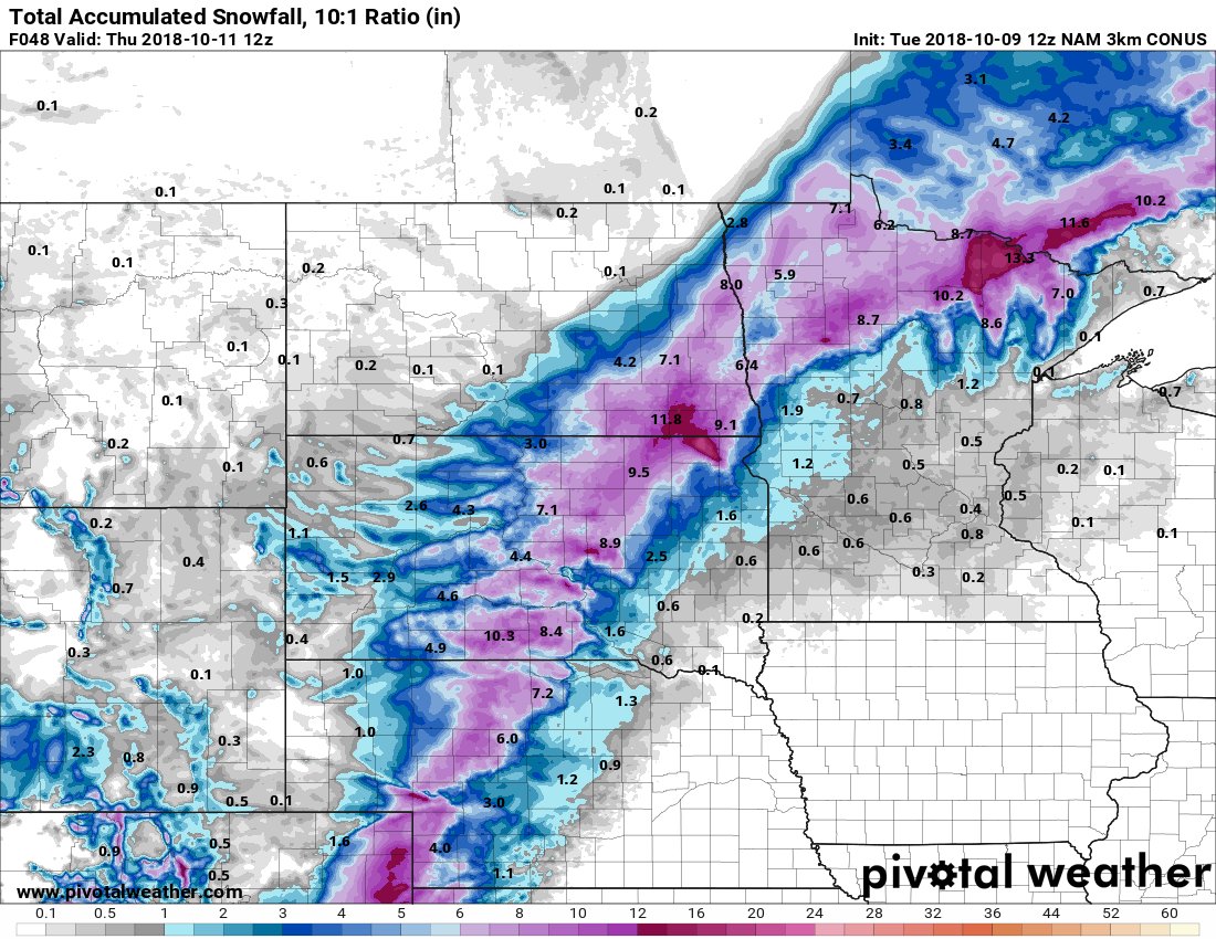
Several inches of snow is expected form the Plains into the Upper Midwest over the next few days. Image provided by Pivotal Weather.
On the other side of the front, where much cooler weather is in place, rain is expected to change over to snow as low pressure rides along the front and into the Midwest. Winter weather advisories have already been posted for parts of the region. Snow is already falling in parts of Colorado this afternoon, and several inches may fall over the next 36-48 hours from western portions of Kansas and Nebraska into the Dakotas and northern Minnesota.
Some heavy rain is possible across our area on Thursday as a strong cold front approaches the region. Image provided by WeatherBell.
As the system moves eastward, it will spread some heavy rain and thunderstorms into our area on Thursday. We’re not expecting any severe weather, but some heavy downpours are possible, especially from western Massachusetts into southern New Hampshire. Some localized flooding may result. Once this front pushes offshore, much cooler weather will settle in for the Friday and the weekend.
You know that dry weather we’ve had for much of the Spring and Summer? How about those warm days with low humidity? Well, both will be a distant memory by this time next week.
A weather pattern that is both typical and atypical of summer at the same time is going to settle into the nation over the next several days. The typical part is that we’ll have a ridge of high pressure off the East Coast, and another one in the Southwest. The ridge off the East Coast will result in heat and humidity up and down the coastline for the next several days. The ridge in the Southwest will bring very hot conditions to the Southwest and especially the Southern Plains, where record highs are expected over the next several days. The Atypical part is across the Midwest. Normally, in between the two ridges of high pressure you’d have a trough of low pressure, but in this case, we actually have a closed upper-level low pressure system. While these are common in the fall, winter, and spring, they usually don’t occur much in the summer. This will bring cooler than normal conditions into the Midwest for the next few days.
What is this, April? The upper-level pattern features ridges of high pressure in the Southwest and off the East Coast, and an upper-level low pressure system in the Great Lakes. Image provided by Pivotal Weather.
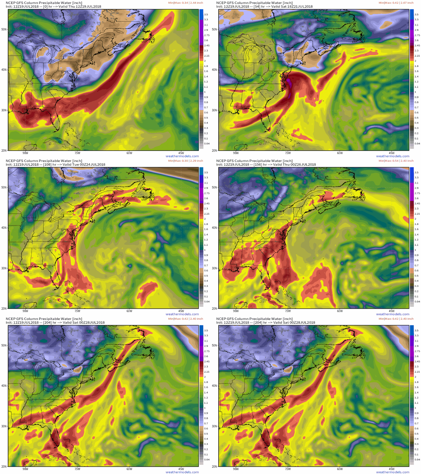
With high pressure anchored off the East Coast, a warm and humid pattern will set up for much of next week (and possibly longer). Notice that we said “warm”, and not “hot”. While temperatures will still be a little above normal this weekend into much of next week, highs will only be in the 80s to lower 90s for most of the Eastern US. While the temperatures won’t be that bad, humidity levels will. With high pressure anchored off the East Coast, a southerly flow will help moisture stream northward from the tropics right up the East Coast this weekend and into much of next week. Dewpoints will be in the upper 60s and 70s across the region, so even though temperatures may not be hot, it will feel oppressive across much of the region.
Moisture will stream northward from the tropics into much of the East Coast over the next several days. Loop provided by WeatherModels.com
With a warm and humid airmass in place for much of the week, it won’t take much for showers and thunderstorms to develop each day. With plenty of available moisture, some of these storms will end up producing very heavy rainfall. While the map above is a forecast that shows widespread coverage of heavy rain, in many cases, the storms will be very localized. Some locations could get hit by slow-moving thunderstorms over and over, while other spots a few miles away get little to no rainfall. Across the Mid-Atlantic States, where heavy rain led to flooding during the Spring, similar conditions are possible again for the next week. Across the Northeast, things are a little different.
That’s a lot of rain from the Carolinas northward over the next week or so. Image provided by College of DuPage.
Here in New England, and in New York too, much of the Spring and early summer has been very dry. Localized thunderstorms have brought heavy rain to a few spots, especially earlier this week, but overall, rainfall has been well below normal across the area. Some relief will come this weekend. A weak low pressure system will move across the region late Saturday into Sunday as an upper-level low pressure system moves into the Midwest. The surface low will bring heavy rain and some gusty winds to parts of Southern New England and southeastern New York. The heaviest rain is expected late Saturday night into early Sunday morning, so neither day should be a complete washout. Once that system moves by, a warm and humid airmass will settle in, with a daily chance for showers and thunderstorms this week. Again, some places could get drenched, and some might get missed completely. Some could see off-and-on showers and storms for 6 hours, some could get a shower that lasts 6 minutes. Basically, it’ll be like living in Florida for a week, without having to worry about looking outside and finding an alligator in your swimming pool.
It’s been very dry across New England and New York for a few months now, with drought conditions developing. Image provided by the National Drought Monitor.
Think warm and humid conditions with a daily chance of thunderstorms isn’t fun? It could be worse. Normally, it’s hot across Texas and the Southwest during the summer. This week though, the ridge of high pressure that is currently setting up across the Southern Plains and Southwest will bring in temperatures that are well above normal. In fact, record highs are expected for the next several days across much of Texas, as temperatures soar past 100 across much of the state, with some locations possibly exceeding 110 degrees. Unlike when the models were forecasting those temperatures here a few weeks ago, this time it’s going to happen. The heat won’t be confined to the Lone Star State either, with triple-digit highs also expected from parts of the Lower Mississippi Valley into the Southern Plains as well as parts of Colorado and New Mexico. There won’t be much, if any, relief at night either, as low temperatures will stay in the 70s, with many locations, especially urban areas like the Dallas-Fort Worth Metroplex likely not dropping below 80 degrees for low temperatures.
Friday looks to be the hottest day across the Southern Plains and Texas, with many record highs expected to be broken. Image provided by WeatherModels.com
As we head into next week, the heat will ease a bit across Texas and the Southern Plains, but the core of the intense heat will shift westward into the Desert Southwest. High temperatures will top 110 degrees across much of the area for the first half of next week, with the usual hot spots such as Lake Havasu City, Arizona; Laughlin, Nevada; and Death Valley, California likely exceed 120 degrees during some of the afternoons. Highs will also top 100 across much of interior California once again. Anyone wanna place a bet as to whether Death Valley reaches 125? Better yet, will they have a night where the temperature doesn’t drop below 100 (it’s happened before)?
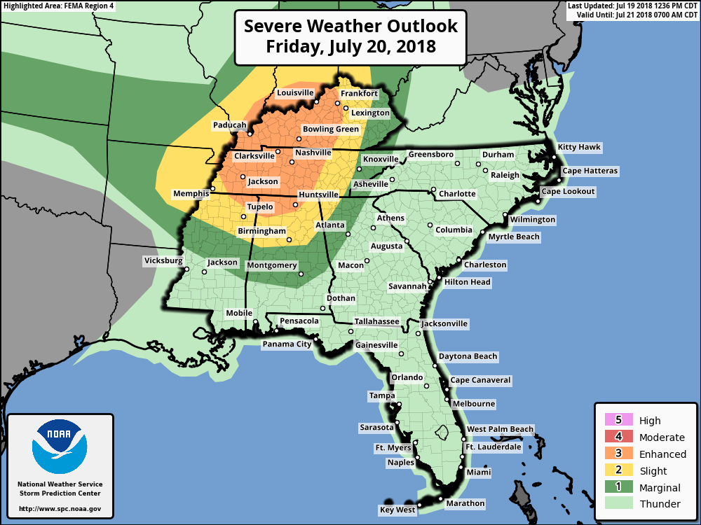
A severe weather outbreak is possible on Friday across the Ohio and Tennessee Valleys. Image provided by the Storm Prediction Center.
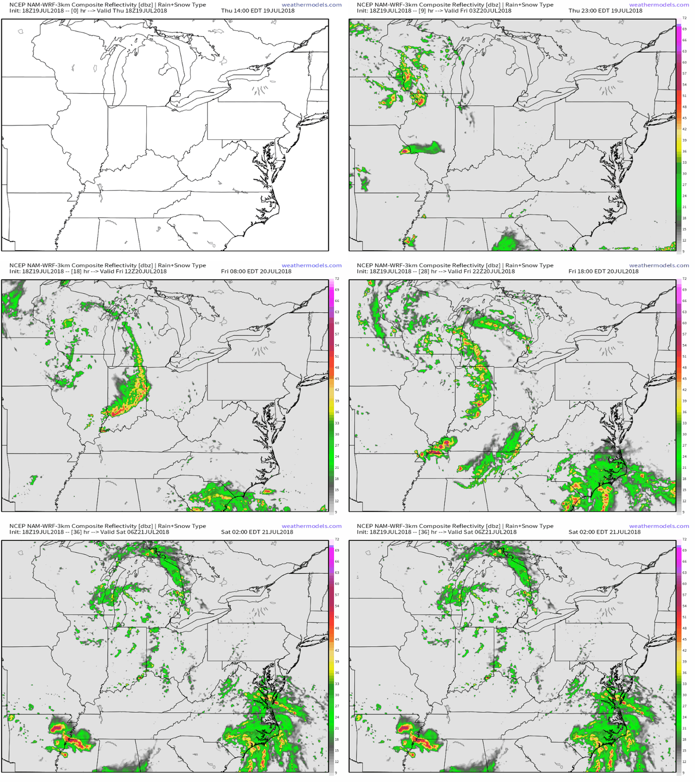
Meanwhile, an upper-level low pressure area will settle into the Midwest. With the clash in airmasses along a cold front, showers and thunderstorms will develop. Some of these storms will become strong to severe on Friday, especially across the Ohio and Tennessee Valleys. The main threats with any storms that develop will be strong winds, large hail, and torrential rainfall that could trigger flash flooding. Some tornadoes are also possible. The storms may start during the morning closer to the Great Lakes, with the afternoon and evening seeing the most widespread activity across the region. While activity should weaken at night, the threat of severe weather will continue across southern and eastern parts of the region.
Strong to severe thunderstorms are expected across the Midwest on Friday. Loop provided by WeatherModels.com
As these storms crossed the Midwest today, they produced wind gusts to 90 mph and more than 30 tornadoes across Iowa. The town of Marhsalltown was devastated by a tornado earlier today. How bad was it? We’ll end this post with the Storm Report from the National Weather Service Office in Des Moines with the description of what happened in Marshalltown:
REPORTS OF CATASTROPHIC DAMAGE, INCLUDING
VEHICLES MISSING, VEHICLES OVERTURNED, TOPS
OF BUILDINGS GONE, TREES DOWN, POWER LINES,
GAS LINES, ETC...
We’ve reached Patriots Day weekend, which is usually one of the truest signs that winter is over and Spring has finally started in New England. This year that will not be the case. In fact, this year, Patriots Day weekend is going to be absolutely miserable.
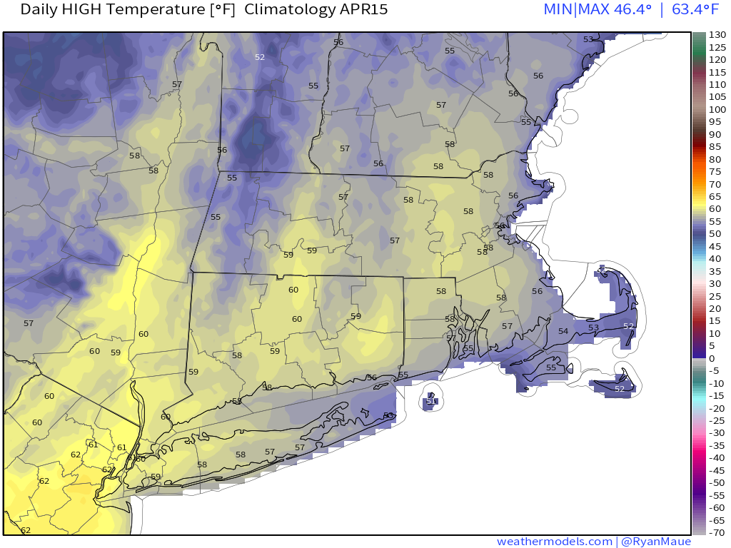
In mid-April, high temperatures should normally be in the middle to upper 50s around here. Image provided by Weathermodels.com
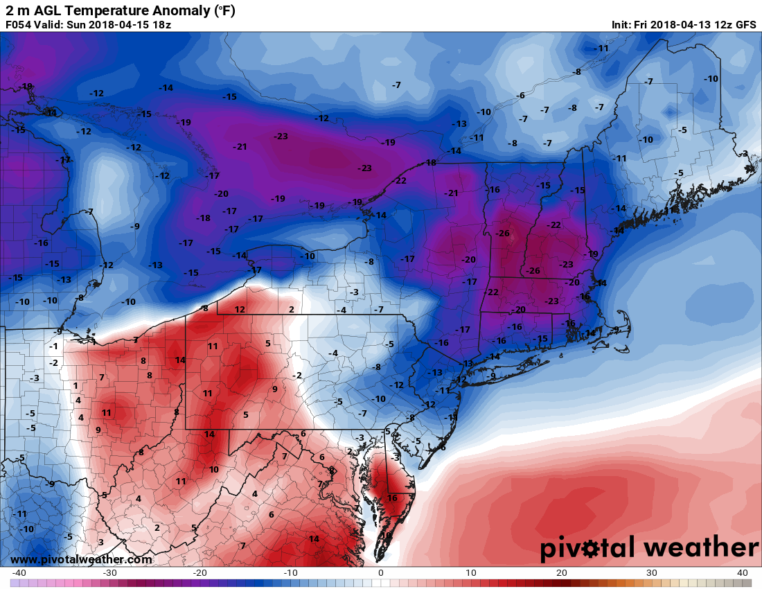
Don’t let today’s warmth fool you. Even though temperatures are in the 60s and even lower 70s away from the South Coast, big changes are coming, and not for the better. A backdoor cold front will drop down across the region late tonight and early Saturday, bringing much colder air back into the region. Temperatures are going to go slowly down through the 40s all day on Saturday and gusty northeast to east winds are going to make it feel even colder. By Saturday evening, temperatures will drop into the 30s, and they’ll likely stay there through most of Sunday. They may start to drift back up Sunday night and Monday, but it will still be on the chilly side. That’s the least of our problems.
Temperatures on Sunday will be 15 to 25 degrees (or more) below normal. Image provided by Pivotal Weather.
A large storm system is going to bring severe weather to the Mississippi Valley and Gulf Coast today and tomorrow, while producing blizzard conditions in the Plains and Upper Midwest, with a significant ice storm expected in parts of the Great Lakes. That storm is going to slowly make progress eastward over the next few days, with the moisture from it likely arriving late Saturday. As we mentioned earlier, temperatures are going to be dropping into the 30s late on Saturday. If you combine that with incoming moisture, you get a giant mess.
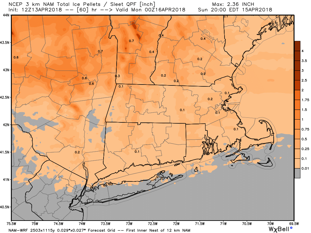
Rain will develop late Saturday afternoon or evening across the region, but as temperatures continue to drop, some sleet will likely mix in, with freezing rain also a possibility, especially north and west of Boston where temperatures could even fall into the upper 20s Saturday night. Sleet and freezing rain will continue across much of the region for a good chunk of the day on Sunday, as temperatures will only rebound into the middle 30s at best for most of the area. The reason we’re expecting sleet (and freezing rain) and not snow, is that the colder air will all be at the lower levels of the atmosphere. It will actually be warmer aloft. We wouldn’t be surprised if the summit of Mount Washington is one of the warmest places in New England Sunday afternoon.
This storm may drop quite a bit of sleet on the region Saturday night into Sunday. Image provided by WeatherBell.
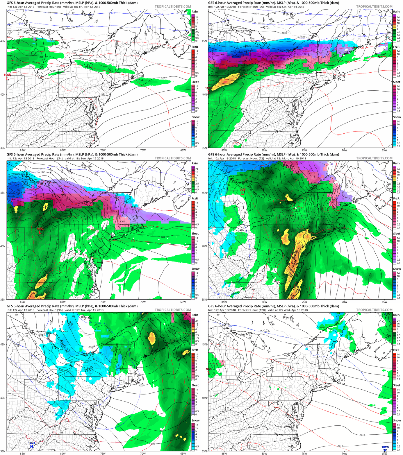
Somewhat milder air will start to filter in Sunday night as low pressure moves into the eastern Great Lakes. This will change everything back over to a cold rain. For once, a cold rain is actually good news, because it means we don’t have to worry about the sleet any more. However, this is bad news as we head into Marathon Monday. As that low heads off to the north and west of the region, it will bring a cold front towards the Northeast. As warmer air surges northward ahead of the front, it will help bring some heavy rain into the area. That warmer air will mainly be aloft, but some of it could reach the surface during the afternoon. In the morning though, when the race starts, and the Red Sox are scheduled to play, we’ll likely have periods of heavy rain, with temperatures only in the upper 30s to middle 40s. Not exactly baseball or running weather. Temperatures could get into the 50s or even low 60s in the afternoon, especially south of Boston, but we’ll still have the heavy rain to deal with. The cold front moves through late in the day, and drier air starts to filter in on Tuesday. Even then, a few showers are still possible as an upper-level low pressure system moves across the Northeast.
The GFS forecast is not pretty for the next few days. Stay inside, watch some playoff hockey, and remember that warmer weather is coming eventually. Loop provided by Tropical Tidbits.
So, is this it for winter? We’d like to say yes, but at this point, we can’t make that statement definitively. Longer-range models show below normal temperatures continuing into much of May. While it’s awfully tough to get wintry weather around here at this time of year, it’s not impossible. We have had heavy snow events in late April (1987), and early May (1977). As some of you may remember, in 2013, up to 3 feet of snow fell in parts of Northern New England and Upstate New York during Memorial Day weekend. So, we’d wait until at least mid-May before taking the flip-flops and shorts out of where ever you stored them for the winter.















 Storm HQ