“Once more unto the breach, dear friends, once more.”
At 12:15 EDT this afternoon, the sun was directly over the Equator, marking the Vernal Equinox, or as it is more commonly known, the start of Astronomical Spring. Here in New England, astronomical seasons don’t have really have much influence on the weather, at least the start and end of those seasons. Take this week for example. Tomorrow is the first full day of spring, but we’re expecting another snowstorm. Yup, that’d be the fourth one this month.
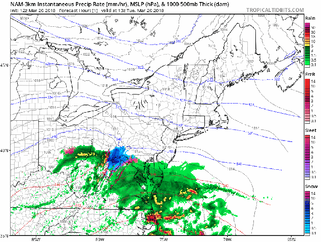
There’s actually a storm passing well south of New England today, so in a sense, we were spared a bit. It’s producing some rain and snow across the Mid-Atlantic states and sending a veil of high clouds across New England, dimming the sunshine this afternoon. Another storm will quickly follow on Wednesday, thickening up the cloud cover. Let’s start out by saying that this storm will not be as bad as the ones we’ve had earlier this month. We’re not expecting blizzard conditions. Oh, we’ll still have a decent amount of snow, strong winds, and some coastal flooding issues, but not at the magnitude of the earlier storms.
We’ll start with the winds and coastal flooding. Tides are astronomically high again this week, so the biggest concern will be at high tide at northeast and north facing beaches, especially the high tides early Wednesday and Thursday morning, as well as Wednesday afternoon. A coastal flood watch is in effect for the early Thursday morning high tide across Plymouth County as well as the Cape and Islands. As for the winds, sustained winds of 20-30 mph are expected, especially along the coast, with gusts of 40-50 mph, perhaps as high as 60 mph across the Cape and Islands, Southeastern Massachusetts, and parts of Rhode Island. Combine that with heavy, wet snow (more on that in a moment), and yes, power outages become a concern once again.

Now, for the part that most of you care about – snowfall. The snow should develop during the afternoon hours on Wednesday. While it’ll be snowing during the afternoon rush hour, it shouldn’t cause too many problems (the people on the roads, however, probably will). With the higher sun angle at this time of year (equivalent to mid-September), and only light snow expected during the daylight hours on Wednesday, accumulations will be fairly light, especially on paved surfaces. Once the sun sets, steadier snow will move in, with the bulk of the accumulating snow expected Wednesday evening into Thursday morning. While the accumulating snow will be all done Thursday morning, light snow and snow showers may linger into the afternoon. We also will likely be dealing with a rain/snow line. A change to rain seems likely across Cape Cod for a while Wednesday evening, with that changeover likely penetrating into parts of southeastern Massachusetts. The question is – how far? Right now, we don’t expect it to get past Route 44, if it even gets that far.
That brings us to the amounts. With temperatures close to freezing, this is going to be a heavy, wet snow, so keep that in mind when you go out to shovel or fire up the snowblower. Here’s what we’re thinking:
Cape Cod: 1-3″, highest totals on the Upper Cape
South Coast: 3-5″
South and East of I-95: 4-7″
Metro Boston/MetroWest/Merrimack Valley/North Shore: 5-9″
Southern NH (Nashua/Manchester)/NH Seacoast: 4-7″

Once this system pulls away, an upper-level low pressure area will slowly move across the Northeast, which may give us some additional snow showers on Friday and Saturday, but we’re not expecting much accumulation (if any), with those. Beyond that – right now, the models aren’t showing any big storms over the next 2 weeks, but that is always subject to change. Remember, just a couple of days ago, most of the TV talking heads told you that this storm was going to stay offshore and we didn’t have to worry about it. As for when we can expect some actual “Spring” weather – well, the pattern looks to remain chilly right into at least early April.
