Weekly Outlook: July 13-19, 2020

Much of this week will feature typical summer-time weather in New England, with warm to hot temperatures, humidity levels ranging from somewhat comfortable to not very comfortable, and some pop-up showers and thunderstorms.
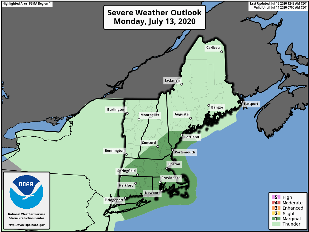
There is a marginal risk for a few severe thunderstorms this afternoon and evening. Image provided by the Storm Prediction Center.

The week starts off with the most active weather day as a cold front starts to approach the region. A few showers are likely this morning as an upper-level disturbance swings through, but we should see some sunshine develop by midday. How much sunshine we get will help determine how much the atmosphere will destabilize again in the afternoon. As the front moves in from the west, showers and thunderstorms will develop. Many of these storms will produce heavy downpours, and some could redevelop over the same locations, resulting in some flash flooding. Depending on how much sun we see in the late morning and early afternoon, we could be looking at some severe storms, with strong winds and hail as well. There is even a slight chance for a tornado to form. How quickly the front moves will also help determine how long we’ll be dealing with the storms, and what areas have the best chance to have them. Right now, it looks like most of the storms will be during the 1pm-8pm time frame.

The HRRR model depicts a possible scenario for thunderstorm development today. Loop provided by Weathermodels.com

The front moves offshore tonight, and cooler and drier air starts to settle in. However, an upper-level low pressure area will be moving in at the same time. As this upper-level low moves right across New England on Tuesday, it will help produce another round of showers and thunderstorms during the afternoon. Most of these shouldn’t be strong, but with a pool of cold air aloft, we could see some small hail in a few of them.
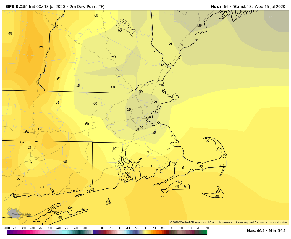
Dewpoints could drop into the upper 50s to lower 60s by Wednesday afternoon. Image provided by WeatherBell.

The upper-level low moves offshore for Wednesday, and we’ll be under the influence high pressure for Wednesday and Thursday, with sunshine, seasonably warm temperatures (tempered by a seabreeze along the coast), and moderate humidity levels. Warmer and more humid air moves in for Friday and the weekend. A series of weak upper-level disturbances will also move across the region, creating a daily chance for showers and thunderstorms.

Heat and humidity return to the region next weekend. Image provided by Pivotal Weather.

Monday: A few showers early, then becoming partly sunny. Showers and thunderstorms are likely during the afternoon and evening. Some of them may produce heavy downpours. High 82-89.

Monday night: Showers and thunderstorms end during the evening, then skies clear out. Low 62-69.

Tuesday: A sunny start, then clouds develop with a few showers and thunderstorms likely during the afternoon. High 76-83.

Tuesday night: Clear to partly cloudy. Low 59-66.

Wednesday: Sunshine and a few clouds. High 72-79, coolest along the coast.

Thursday: Some patchy morning fog, then becoming partly to mostly sunny. High 74-81, coolest along the coast.

Friday: Intervals of clouds and sunshine with some showers and thunderstorms possible, especially during the morning, a little more humid. High 77-84.

Saturday: Partly sunny, chance for a shower or thunderstorm. High 83-90, cooler along the coast.

Sunday: A mix of sun and clouds, a shower or thunderstorm is possible. High 86-93.

Another Short-Lived Tropical Storm Develops

The 2020 Hurricane Season has had two themes so far: 1. Tropical Storms that aren’t really tropical. 2. Storms that fall into the “Blink and you’ll miss it” category. We’ve got another one out there, and this is squarely in category #2.

Fay looks like a typical tropical system impacting the Northeast, with the bulk of the clouds and precipitation north and west of the center. Loop provided by NOAA.

A disturbance that moved from the Gulf of Mexico and into the Southeast last week moved off the South Carolina coast on Wednesday. After sitting over the warm waters of the Gulf Stream, thunderstorm activity began to increase, and a new center of circulation developed Thursday afternoon. Air Force Reserve Hurricane Hunters investigating the system determined that it had a closed circulation (barely), and the system was designated as Tropical Storm Fay.

Forecast track for Tropical Storm Fay. Image provided by the National Hurricane Center.

Fay is the 6th named storm of the season (Whether all 6 deserved to be named is highly debatable), and is the earliest we’ve ever had an “F” storm in the Atlantic. The previous record was held by Tropical Storm Franklin during the 2005 season, which developed on July 22. Despite the record start in terms of named storms, most of the storms have been short-lived and of little impact. Meteorologists use a metric called ACE (Accumulated Cyclone Energy) to determine the severity of a hurricane season. It takes into account how strong storms are, how long they remain strong, and how long they last. Despite having 6 named storms so far, the Atlantic has an ACE of 7.4 this season. While this is more than double the normal through July 10 of 3.1, it is exactly the same as the Western Pacific Ocean, where only 2 storms have formed so far this year.

Tropical Cyclone Activity is below normal across the Northern Hemispehere thus far, despite the “active” Atlantic. Image provided by Colorado State University.

While there are still a few minor details that need to be determined, Fay’s future is fairly clear. With a ridge of high pressure in the western Atlantic, and a trough of low pressure moving into the Great Lakes, Fay should head northward for the next 24 hours, hugging the Mid-Atlantic coastline. The official forecast from the Hurricane Center has Fay make landfall near Atlantic City later today, but a slight jog to the east will keep the center offshore longer, with landfall farther to the north. A Tropical Storm Warning is in effect from Fenwick Island, Delaware to Watch Hill, Rhode Island, including Long Island Sound. This includes southern Delaware Bay as well all of Long Island and southern Connecticut, and also New York City.

Most of the rainbands assoc

Fay currently has maximum sustained winds near 60 mph (Edit: Yeah, right), and little additional strengthening is expected before landfall. The storm is moving northward at 12 mph, and should pick up a little speed today. This track will keep most of the strongest winds offshore, but right along the coast winds will remain brisk. Sustained winds near 40 mph were reported along the Delaware coast earlier this morning.

Fay will help put a dent in the developing drought across the Northeast. Image provided by the National Drought Mitigation Center.

Fay’s biggest threat will be heavy rainfall that could lead to flash flooding, especially from the Mid-Atlantic states into eastern New York and western New England. Much of this region has been dry for a few months, and drought conditions are beginning to develop. Some of this rainfall will help alleviate that, but too much rainfall too quickly will just run off and not help much at all. By the time Fay pulls away early Saturday, rainfall totals of 2-5 inches are expected from the Delmarva Peninsula into western New England and eastern New York, mainly along and just west of the expected track of Fay. Some isolated totals in excess of 6 inches are possible. Amounts will taper off the farther east or west you head away from this area.

The heaviest rain is expected from the Mid-Atlantic states into the Hudson Valley. Image provided by Weathermodels.com

Once Fay dissipates, there don’t appear to be any other areas that may develop in the next week or two. It’s still early in the season, and easterly waves will begin rolling off of western Africa soon, with the climatological peak of hurricane season still more than a month away.

Weekend Outlook: July 10-13, 2020

Despite the gloom and doom you may have heard or read about elsewhere, this weekend is not going to be a washout.

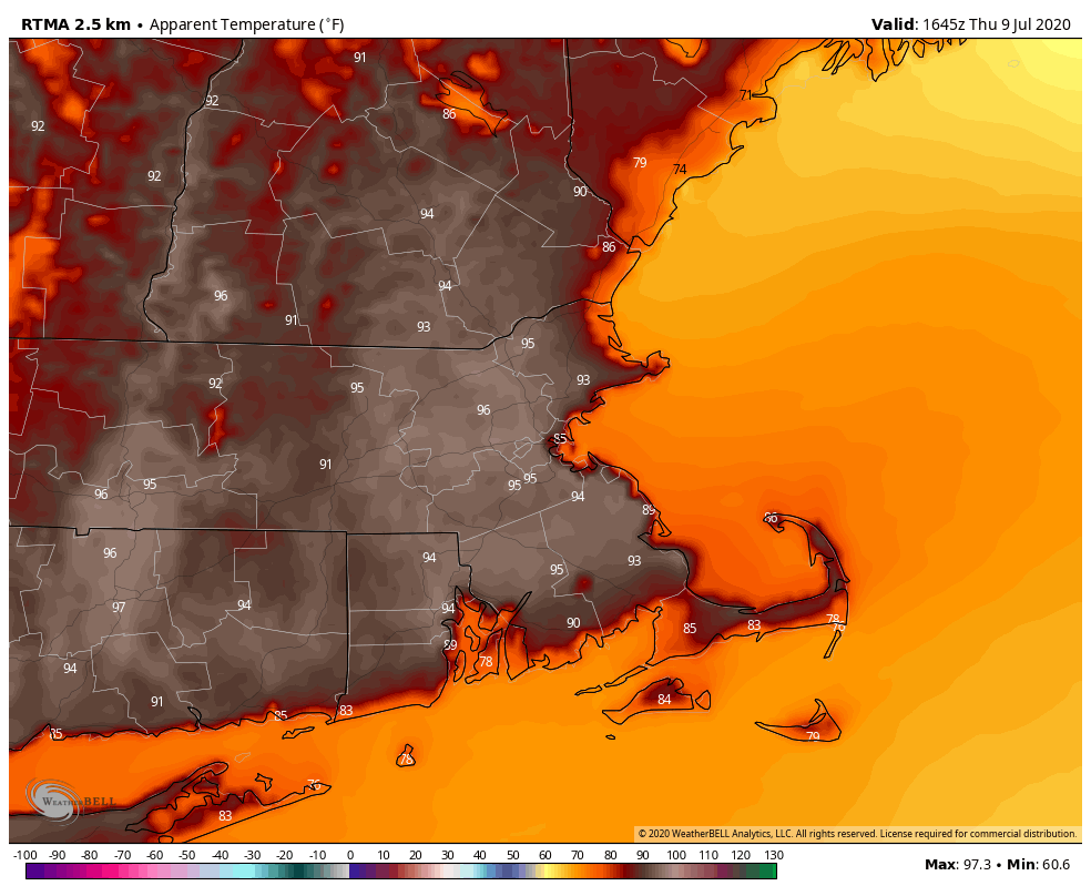
The heat index is already in the mid-90s across much of the region early this afternoon. Image provided by WeatherBell.

High pressure remains in control for the rest of your Thursday afternoon, with warm to hot and humid conditions. A pop-up shower or thunderstorm is possible, but if any do form, they’ll be few and far between, and most of us will remain dry. Another warm and muggy night is expected tonight before we turn our attention to Friday.

Ensemble forecasts keep the track of the system close to the coast, and well to our west. Image provided by the University at Albany.

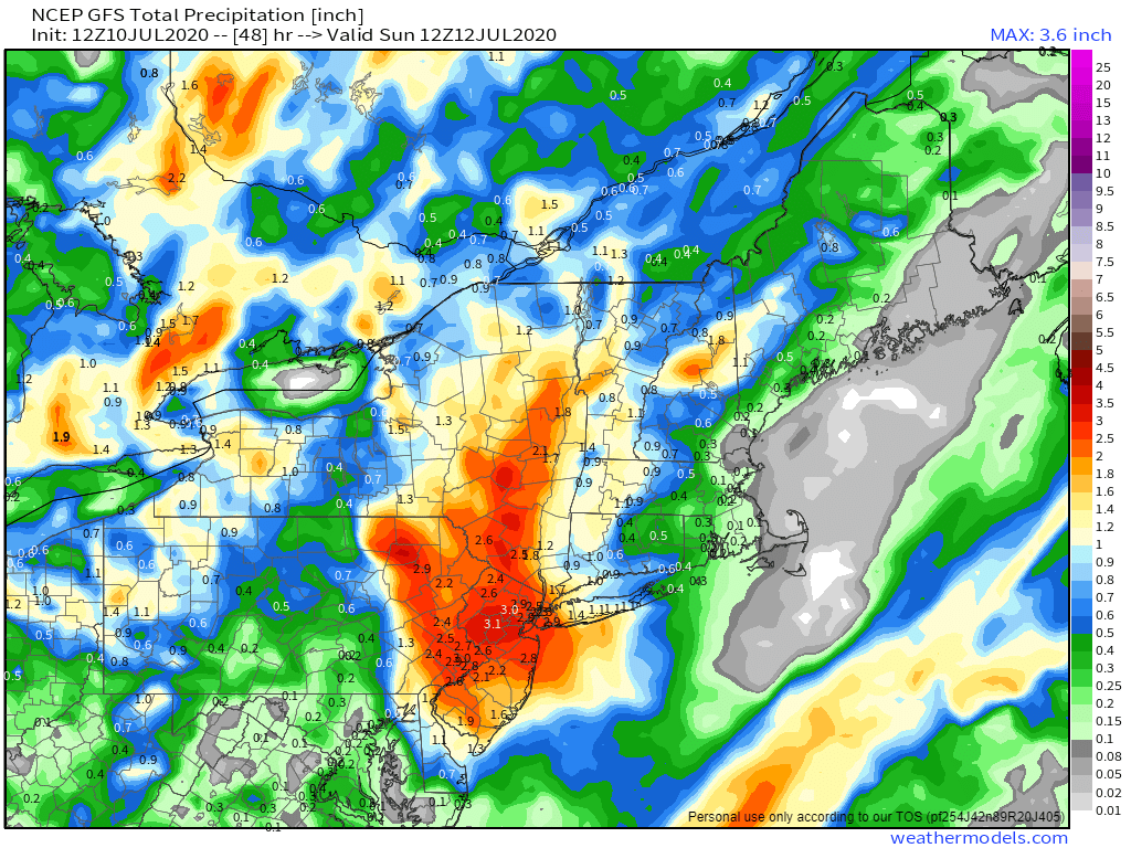
An area of low pressure is trying to develop off the North Carolina coastline this afternoon. Whether this system develops or not, it will head northward over the next 24-48 hours. This will send a surge of tropical moisture northward, resulting in some heavy rain and thunderstorms. Obviously where the heavy rain ends up being focused will be dependent on the eventual development and track of the system, but right now, it looks like the heaviest rain should stay well to our west. Sure, we’ll have some heavy showers and thunderstorms, mainly from late Friday afternoon into early Saturday morning, but this should not be a big deal. Some of the thunderstorms could be quite strong, with gusty winds, downpours, and an isolated tornado is possible, but aside from the slim chance for a tornado, we’ve been dealing with similar conditions for the past couple of weeks on a regular basis.

The heaviest rain should stay well to our west with this system. Image provided by Weathermodels.com

The showers should end Saturday morning, with partial sunshine developing for the afternoon. However, a warm and humid airmass will remain in place, so we could pop a few showers and thunderstorms again during the afternoon hours. Beyond that, it’ll be more of the same. We’ll have an upper-level trough of low pressure moving into the Northeast, which will help to trigger some afternoon showers and thunderstorms both Sunday and Monday afternoons, but otherwise, it’ll just be partly to mostly sunny, very warm, and humid.

We usually don’t forecast more than a week out, and this outlook is focusing mainly on this weekend, but we think it’s worth mentioning that some of the long-range guidance is showing the potential for a significant heat wave late next week into the following week. While the core of the heat will likely be focused on the Midwest and parts of the Plains states, it could still get hot around here as well. We’ll have a better look at this in our Weekly Outlook that will be issued early Monday morning.

There is a moderate risk for excessive heat in our area next weekend into the following week. Image provided by the Climate Prediction Center.

Thursday night: Clear to partly cloudy. Low 65-72.

Friday: Becoming cloudy with showers and thunderstorms developing in the afternoon. High 81-88.

Friday night: Cloudy with showers and thunderstorms likely, some of them may produce heavy rain. Low 65-72.

Saturday: Showers end early, then becoming partly sunny, but another round of showers and thunderstorms is possible in the afternoon. High 79-86.

Saturday night: Clear to partly cloudy. Low 66-73.

Sunday: Sunshine and some afternoon clouds, chance for a few late-day showers or thunderstorms. High 82-89.

Sunday night: Clear to partly cloudy. Low 64-71.

Monday: A mix of sun and clouds with a few afternoon showers and thunderstorms possible. High 82-89.

Weekly Outlook: July 6-12, 2020

We’ve got some typical summertime weather coming up for most of the week, with heat, humidity, and thunderstorms all expected.

The week starts off with high pressure building in from the north, which will bring in sunshine, lower humidity, and slightly cooler temperatures, especially along the coast. By Tuesday, however, that high will move off to the south, allowing more humid air into the region, along the the chance for a few showers and thunderstorms.

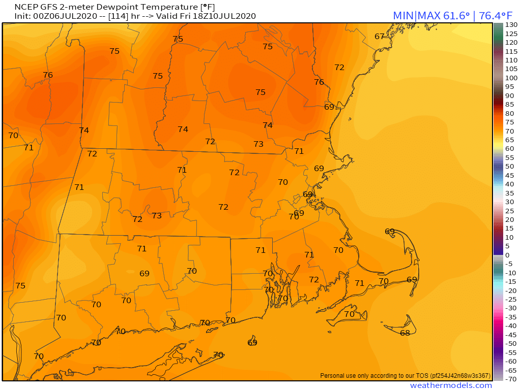
You’ll start to hear the “Triple-H” talk for Wednesday through Friday, but it may not quite qualify. It’ll be quite warm to hot, with temperatures will into the 80s and lower 90s in many locations. It’ll also be quite humid, as dewpoints will get well into the 60s, and possibly even lower 70s. Will it be hazy? Probably not. Even without the haze, it’ll still be quite comfortable for a lot of people.

Dewpoints could be in the 70s across the region by Friday afternoon. Image provided by Weathermodels.com

The end of the week and into the weekend is a bit of a question mark right now. Low pressure currently over the Southeast will move off the Carolina coastline by midweek, and then head northeastward up the coastline. The National Hurricane Center has already given it a 40% chance of development before the end of the week. Given their recent track record, we’re assuming that assuming it moves off the coast, as long as it’s spinning and has a thunderstorm nearby, it’ll be called Tropical Depression Six, or maybe they’ll go right to Tropical Storm Fay. Either way, it may very well have some impact here by Friday or Saturday. The most likely impact is for some heavy rainfall. We’ll already have a very soupy airmass in place, and adding tropical air to that will help wring out even more moisture. While this will help put a dent in the developing drought for some areas, it may also lead to flooding in others. We could also see some impacts from wind, depending on the development of the system, and rough surf along the coast. Unsettled weather may hang around through the weekend, as the system may be slow to depart.

Low pressure over the Southeast could become a tropical system and track up the coast later this week. Image provided by the National Center for Atmospheric Research,

Monday: Partly to mostly sunny. High 77-84, cooler along the coast.

Monday night: Partly cloudy. Low 57-64.

Tuesday: A mix of sun and clouds, just a slight chance for an afternoon shower or thunderstorm. High 76-83.

Tuesday night: Partly cloudy. Low 61-68.

Wednesday: Partly sunny with showers and thunderstorms likely in the afternoon. High 81-88.

Thursday: Sunshine and a few afternoon clouds, a shower or thunderstorm may pop up. High 86-93.

Friday: Early sun, then clouds move in, some showers and thunderstorms develop, possibly become a steady rain late in the day and at night. High 84-91.

Saturday: Rain ends early, then becoming partly sunny, a few showers and thunderstorms are possible in the afternoon and evening. High 80-87.

Sunday: Intervals of clouds and sun, more showers and thunderstorms are possible. High 82-89.

Weekend Outlook: July 3-6, 2020

We’ve passed the midpoint of the year, and arrived at the Fourth of July weekend, so everything will be great for a barbecue, right? For the most part.

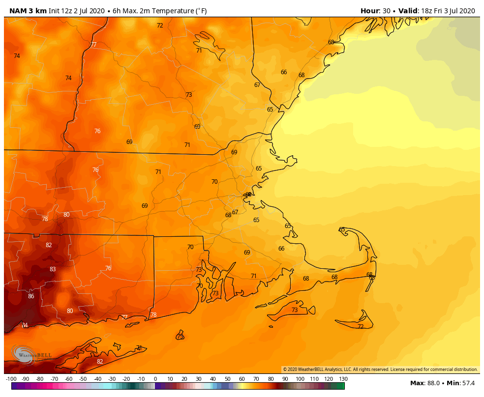
High pressure remains in control for the rest of the day, though a few showers and thunderstorms are possible, mainly well north and west of Boston trough the evening. Friday will be a different story. We’ve got a backdoor cold front dropping down (what month is this?) and it will bring in plenty of clouds, some showers, and maybe even a thunderstorm. We’ll likely reach our highs for the day during the morning, with steady or falling temperatures in the afternoon.

Temperatures on Friday will not be typical for early July. Image provided by Weathermodels.com

High pressure drops southward on Saturday, resulting in more sunshine for the Fourth of July. However, with easterly winds, it will be on the cool side, especially if you’re closer to the coast. Temperatures will be 5-10 degrees below normal, with most places staying in the 70s, but a few coastal locations may stay in the 60s.

The high slides offshore Saturday night, allowing milder air to move back in, but another cold front will be approaching on Sunday. This front will probably produce a few showers and thunderstorms, but the day likely won’t be a washout. Another disturbance may bring in some additional showers on Monday.

The thunderstorms over the last week helped a little, but we still need more rain to help alleviate the developing drought. Image provided by the National Drought Mitigation Center

Thursday night: Partly cloudy, slight chance for an evening shower. Low 63-70.

Friday: Becoming mostly cloudy with some showers and possibly a thunderstorm. High 70-77 in the morning, temperatures drop a bit in the afternoon.

Friday night: Mostly cloudy with areas of fog. Low 57-64.

Independence Day: Becoming partly to mostly sunny. High 73-80, coolest along the coast.

Saturday night: Clear to partly cloudy, some fog may redevelop, especially across southeastern Massachusetts. Low 58-65.

Sunday: A mix of sun and clouds, chance for some afternoon showers or thunderstorms. High 80-87, cooler along the coast.

Sunday night: Partly cloudy. Low 60-67.

Monday: Intervals of clouds and sunshine with showers and thunderstorms possible. High 80-87.

Weekly Outlook: June 29 – July 5, 2020

This is going one of those weeks where the weather app on your phone just won’t cut it. Most of those apps will give you a little icon for the day, and for this week, we wouldn’t be surprised if there was a little thunderstorm icon in there for every day. Yes, there will be a chance of thunderstorms for almost every day this week. However, the vast majority of the time will be dry, and none of the days should be a washout.

Satellite loop showing the explosive development of Sunday’s storms from midday through sunset. Loop provided by the College of DuPage.

After widespread strong to severe thunderstorms on Sunday, things should be a bit more quiet today. We’ve got an upper-level low pressure settling into the northeast, so we’ll see clouds popping up, and some showers and thunderstorms will likely develop this afternoon. This will be nothing like yesterday however. Sure, a few of the storms may produce a quick downpour or even some small hail due to some cold air aloft, but they’ll be hit and miss storms, with more areas getting nothing than areas that get storms. Most of the activity should diminish with the setting sun.

Much of the region received beneficial rain on Sunday. From northern Rhode Island into Metro Boston, rainfall totals of 1-4″ and heavier were common. Image provided by NOAA.

That upper-level low will remain nearby for Tuesday and Wednesday, so we’ll have similar conditions both days with showers and thunderstorms popping up each afternoon, produce a few downpours and maybe a little hail, but nothing widespread is expected. Temperatures will be on the cooler side, possibly even a little below normal for the end of June/beginning of July, with highs only in the 70s for most of us, with some coastal locations possible staying in the 60s thanks to a wind off the water.

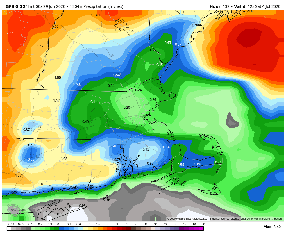
Despite the chances for rain every day, we’re not actually expecting a lot of rain this week. Image provided by Weathermodels.com

The upper-level low finally starts to move out on Thursday, but it still may produce a few showers and thunderstorms. After it moves out, a ridge of high pressure starts to build in…..to the Midwest. That means another upper-level trough of low pressure starts to build in for Friday and the weekend. So, we’ll be a bit warmer, but, you guessed it, we’ll have a daily chance for some pop-up showers and thunderstorms. Wash. Rinse. Repeat. Things may start to dry out a bit more on Sunday.

Average high temperatures for the start of July are in the upper 70s to lower 80s. Image provided by Weathermodels.com

Monday: Some patchy fog to start the day, otherwise more clouds than sunshine, chance for some showers and thunderstorms. High 73-80, a little cooler along the coast.

Monday night: Showers taper off in the evening, then partly to mostly cloudy with some fog redeveloping. Low 59-66.

Tuesday: Intervals of clouds and sunshine, chance for a few showers and thunderstorms. High 69-76, a little cooler along the coast.

Tuesday night: Partly to mostly cloudy, again some patchy fog is possible. Low 60-67.

Wednesday: A mix of sun and clouds with some afternoon showers and thunderstorms possible. High 72-79.

Thursday: A sunny start, then clouds pop up, just a slight chance for a shower or thunderstorm. High 80-87, a little cooler along the coast.

Friday: Morning sunshine then afternoon clouds, a shower or thunderstorm may pop up. High 77-84.

Independence Day: Partly sunny with an afternoon shower or thunderstorm possible. High 75-82.

Sunday: Sunshine and a few clouds. High 78-85.

Weekend Outlook: June 26-29, 2020

The forecast for this weekend is rather simple, yet complicated at the same time.

While fair-weather cumulus are popping across interior areas, high clouds are streaming across southeastern New England this afternoon. Loop provided by the College of DuPage.

We’ve got a nice afternoon in progress with sunshine, warm temperatures, and lower humidity, but as is usually the case, that won’t last too long. A weak disturbance moves through tonight, with a few showers, possibly a thunderstorm, focused mainly south of the Mass Pike. High pressure then slides offshore on Friday, with southwest winds, bringing more humidity back to the region. It won’t be as humid as Wednesday was, but it’ll be more noticeable than today.

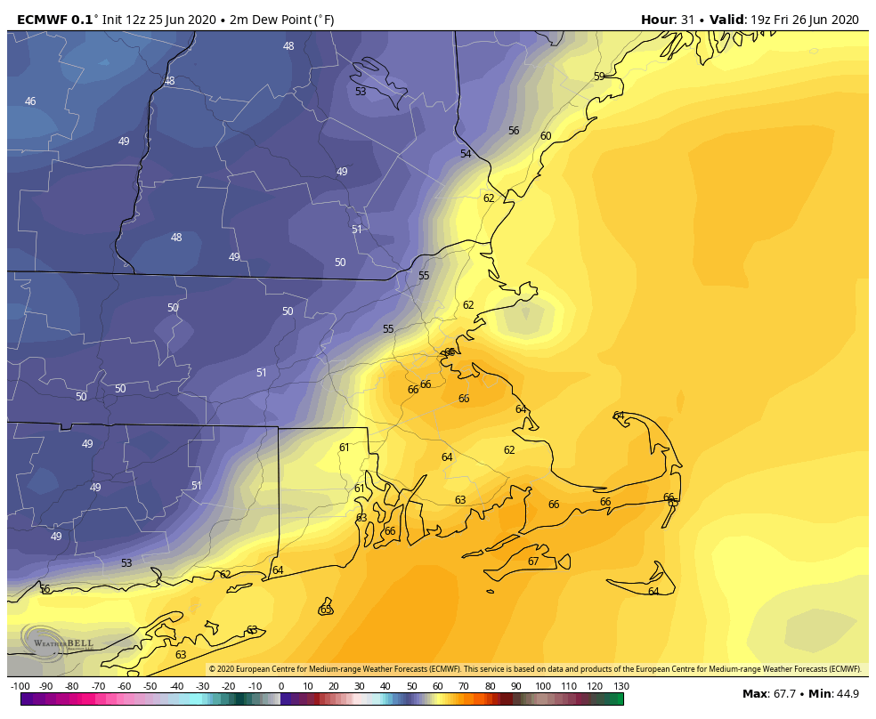
Dewpoints will get back into the 60s across parts of the region on Friday. Image provided by WeatherBell.

By late Friday, a low pressure area will move across Ontario and into southern Quebec. A warm front ahead of the low will move across the area Saturday morning, resulting in another warm and humid day, but with a bit more in the way of cloudcover. As the low continues to move eastward, it will drag a cold front across the region late Saturday night and into Sunday. This front will produce some showers and thunderstorms late Saturday afternoon and into Saturday night. This is where things get complicated.

Conditions will be favorable for some strong to possibly severe thunderstorms if everything falls together properly. If we get enough sunshine, conditions could become unstable enough for strong to severe storms to form. Some of the storms could produce strong winds and heavy downpours. However, if there’s more in the way of cloudcover, and temperatures are a bit cooler, then we’d just be looking at showers and a few thunderstorms late Saturday and Saturday night.

Some strong to severe thunderstorms are possible late Saturday, but the highest risk for severe weather is to our west and southwest. Image provided by Pivotal Weather.

Showers may linger into Sunday as the front moves offshore. As has been the case for a while now, there will be a few spots that pick up some heavy rain in downpours, but most of us will see just a little or even no rainfall. This will provide little to no relief from the drought conditions that are developing across the region. High pressure starts to build in later on Sunday with clearing likely at night, and then Monday should feature seasonably warm temperatures and low humidity, but with an upper-level low pressure area moving through, a few pop-up showers are possible.

The drought is starting to get a little worse across the region. Image provided by the National Drought Mitigation Center.

Thursday night: Partly to mostly cloudy with a few showers or thunderstorms possible across Rhode Island and southeastern Massachusetts, clear to partly cloudy elsewhere. Low 60-67.

Friday: Sunshine and some afternoon clouds. High 80-87.

Friday night: Clear to partly cloudy. Low 59-66.

Saturday: Intervals of clouds and sunshine, some showers and thunderstorms are expected during the afternoon and evening. High 78-85.

Saturday night: Partly to mostly cloudy, showers and storms gradually taper off. Low 62-69.

Sunday: More clouds than sun, some additional showers are possible. High 83-90.

Sunday night: Clear to partly cloudy. Low 61-68.

Monday: A mix of sun and clouds, slight chance for a shower or thunderstorm. High 80-87.

A New “Tropical” System in the Atlantic

The National Hurricane Center is tracking another system in the Atlantic, but the only threat it presents is to the Hurricane Center’s credibility.

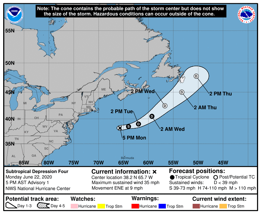
Official forecast track for “Subtropical Depression Four”. Image provided by the National Hurricane Center.

Late Monday afternoon, the National Hurricane Center started issuing advisories on “Subtropical Depression Four”, which was centered a little more than 300 miles southeast of Nantucket. Their forecast calls for it to strengthen into a Tropical Storm tonight, at which time it would be given the name “Dolly.” The system should head eastward then northeastward, staying over open waters before it weakens and then, according to the forecast, becomes “extratropical”. Here’s the problem. It’s extratropical now, and has been the entire time.

Satellite loop from Monday afternoon showing “Subtropical Depression Four” south of Nova Scotia. Loop provided by NOAA.

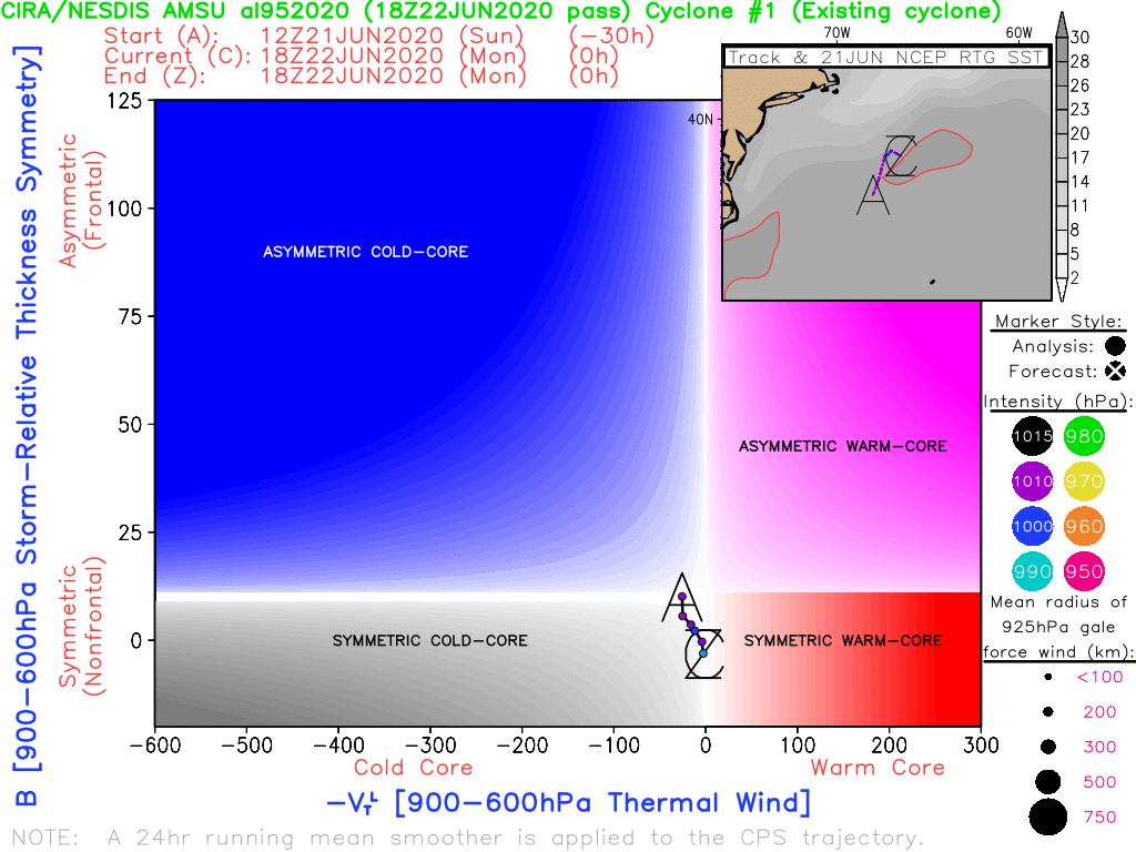
To be considered a tropical or even subtropical system, it needs to be “warm core.” What that means, is that temperatures are warmest at the center of the storm, and cooler as you head away from the center. In some stronger hurricanes, like Dorian from last year, temperatures can be as much as 20 degrees warmer in the eye compared to just outside the eye.

Analyzed data from satellite photos shows that “Subtropical Depression Four” is a cold-core system. Image provided by Florida State University.

Tropical systems also need warm water to feed them and help them strengthen. The threshold is generally accepted as 27C (80F) as the minimum needed for a tropical system to maintain itself and/or strengthen. This system is over the northern edge of the Gulf Stream, which is fairly mild, but water temperatures in the region are 25-26C, and quickly drop to 22-24C just to the east of the system’s current location. That’s not warm enough to sustain a “tropical” system.

Current Sea Surface Temperature analysis of the North Atlantic Ocean. Image provided by Tropical Tidbits.

Lastly, and this partially refers back to the first point we made about the system being cold-core, the storm itself is centered under an upper-level low pressure system. Tropical systems usually need an upper-level high pressure system over them, to help vent the rising air near the center. The stronger the high aloft, the more a tropical system will strengthen. A storm sitting under an upper-level low is the same as most of the storms that we see impacting us all through the year – extratropical. As you can see in the analysis below, there is a trough of low pressure extending southward from the system. It’s not quite a cold front, but close enough. Extratropical systems have fronts and/or troughs extending from them, tropical systems don’t.

Surface analysis of the Western Atlantic Ocean from Monday afternoon. Image provided by the Ocean Prediction Center.

Assuming this gets named Dolly, it will be our fourth named “tropical” system this year. However, only one, Cristobal, was ever truly tropical. Cristobal was a tropical storm when it moved into southern Mexico. When it moved back over the Gulf and headed towards Louisiana, it was already extratropical, even though the Hurricane Center didn’t declare it extratropical until it got into Iowa.

It’s been a running joke among meteorologists for years that if a system is over water and has a thunderstorm nearby, it’ll get a name from the “National Thunderstorm Center.” This storm is just further proof of that. With many forecasts for an active hurricane season, every system is going to get named to pad the stats and help verify that forecast. We’ve had colleagues joke that by the time this season is over, we’ll have gone through the entire name list and the Greek Alphabet. We not only agree with that sentiment, we even made a prediction elsewhere that “Tropical Storm Lambda” will produce 70 mph winds on Nantucket in late December while bringing 6-12 inches of snow to southern New England. As long as there’s a thunderstorm in the warm sector, it’ll get a name.

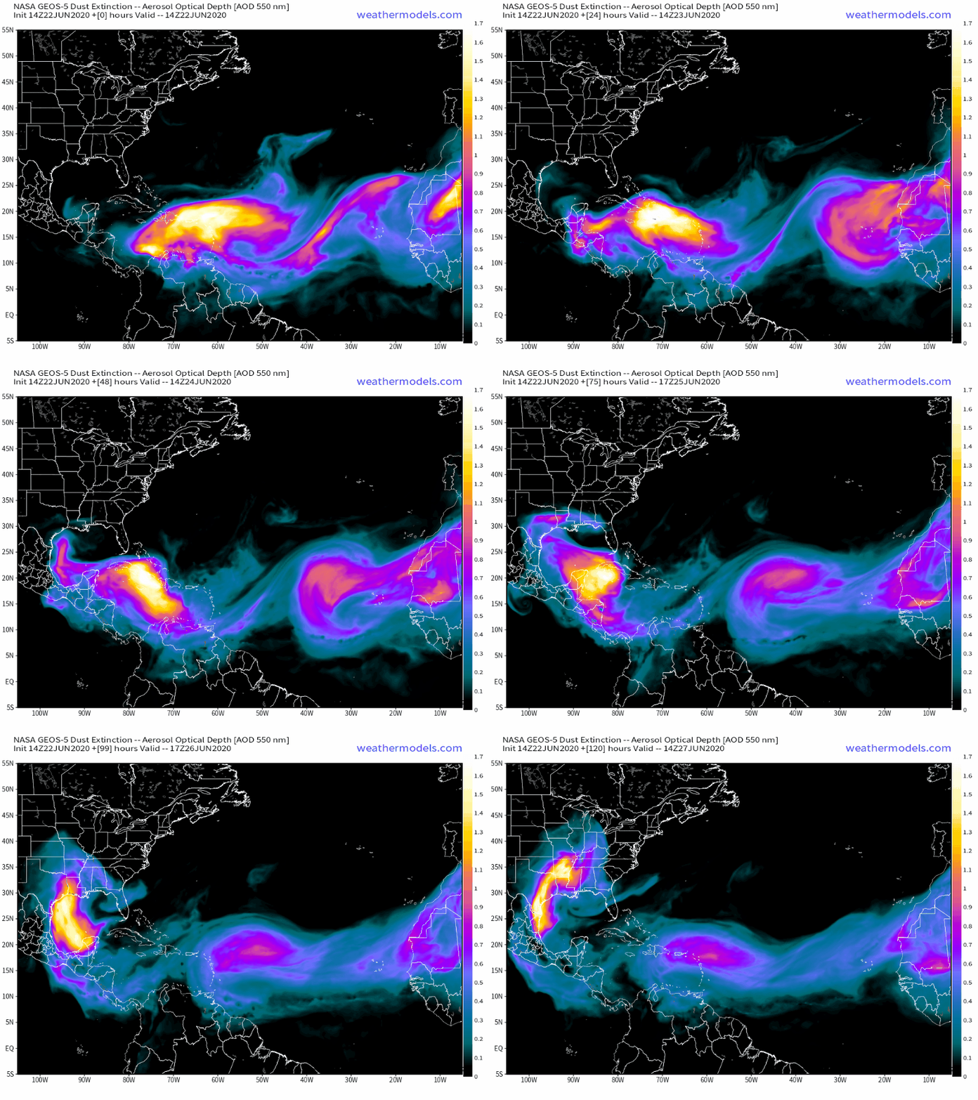
Plumes of Saharan Dust will continue to cross the Atlantic over the next several days. Loop provided by Weathermodels.com

As far as actual tropical systems, none are forthcoming in the Atlantic for at least a week or two, thanks to several plumes of Saharan dust moving off the coast of Africa and across the Atlantic over the next several days. The dust is accompanied by very dry air, which suppresses thunderstorm activity.

Weekly Outlook: June 22-28, 2020

No matter how you define summer, it is now officially here in the Northern Hemisphere, and we’ll feel it all week long.

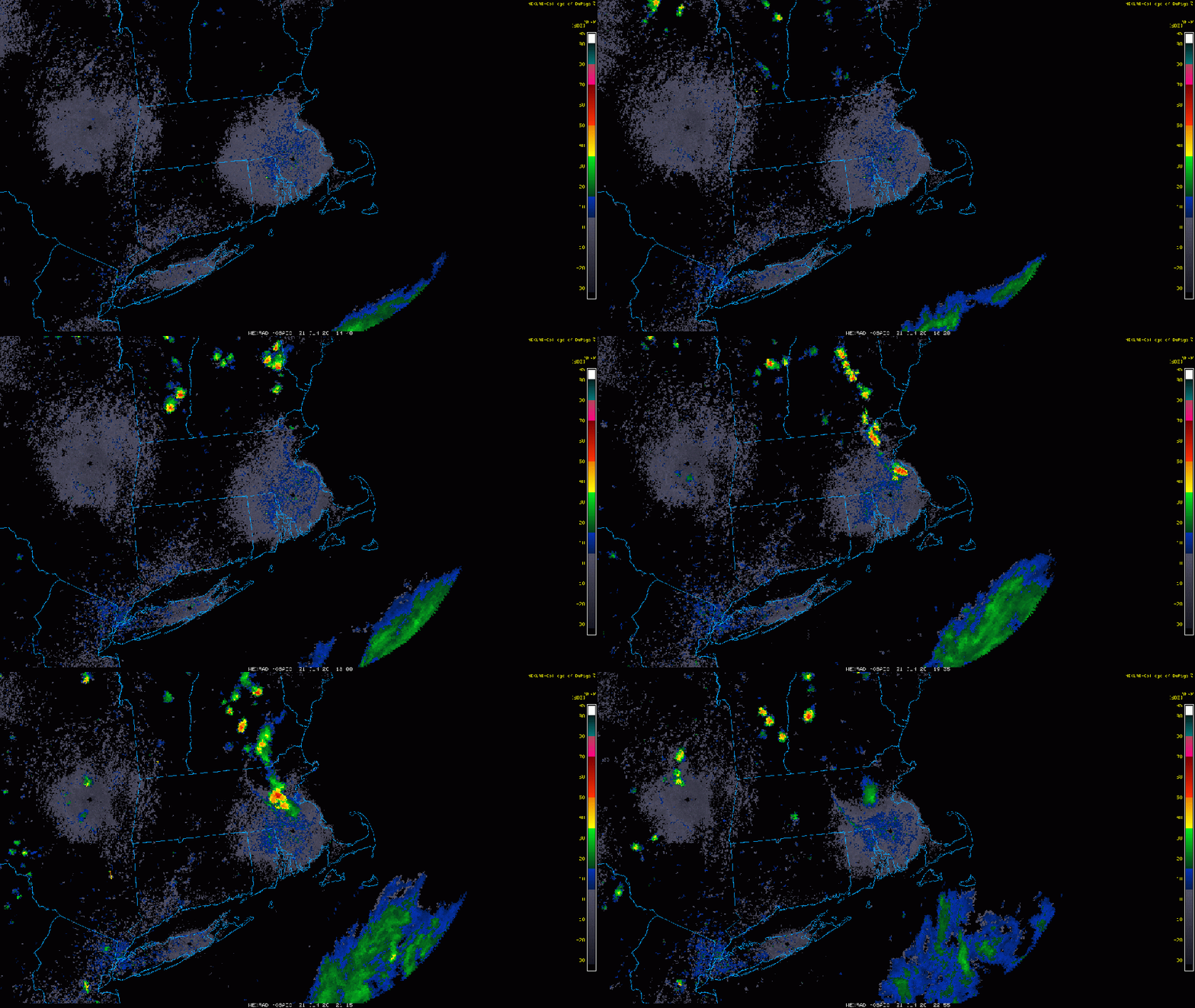
The past few days have all featured the same general pattern. A muggy start to the day with low clouds and fog across southern Rhode Island and southeastern Massachusetts, then sunshine, some fair-weather cumulus clouds, warm to hot temperatures, moderate to somewhat high humidity, a few pop-up showers and thunderstorms during the afternoon, diminishing by evening, then low clouds and fog return to the South Coast. Wash. Rinse. Repeat. Well, that general pattern will continue today and Tuesday with one added wrinkle – a seabreeze along the coast. That actually started on Sunday, which helped to produce the heavy thunderstorms across eastern Massachusetts. It will likely be the case today, and probably Tuesday as well.

Locally heavy showers and thunderstorms developed on Sunday. Loop provided by the College of DuPage.

By Wednesday, we start to get some changes. A cold front will be approaching from the west as low pressure passes north of the region. We’ll still have morning low clouds and fog, and it’ll still be warm to hot and fairly humid, but the cold front will help produce a little more in the way of thunderstorm activity Wednesday afternoon and evening. The timing of the front will have a hand in determining how strong the thunderstorms get, but right now, it does not look like a widespread severe event.

Some of Wednesday’s storms could be locally heavy, but a widespread heavy rain event is not likely. Image provided by WeatherBell.

The front moves through at some point Wednesday night early Thursday, then high pressure builds in with some drier weather for Thursday into Friday. Temperatures will still be quite warm, but with lower humidity, it will feel a bit more comfortable. The weekend is a bit of a question mark at this point. Another system will likely pass north of the region, with some showers and thunderstorms possible, but there is plenty of disagreement among the models in regards to the timing of the system. Either way, it doesn’t look like much to worry about, with neither day being a washout.

Dewpoints will drop into the 50s across much of the region Thursday afternoon. Image provided by Weathermodels.com

Monday: Low clouds and fog to start the day across the South Coast, and also from the North Shore to the New Hampshire Seacoast, then skies become partly to mostly sunny, a few showers and thunderstorms are possible during the afternoon, mainly well inland. High 85-92 inland, 77-84 along the coast.

Monday night: Clear to partly cloudy, low clouds and fog return to the South Coast. Low 61-68.

Tuesday: A mix of sun and clouds, chance for a few showers and thunderstorms during the afternoon. High 85-92, cooler right along the coast.

Tuesday night: Clear to partly cloudy, low clouds and fog return to the South Coast once again. Low 63-70.

Wednesday: Intervals of clouds and sunshine with scattered showers and thunderstorms likely during the afternoon and evening, tapering off before midnight. High 83-90, cooler along the South Coast.

Thursday: Partly to mostly sunny and less humid. High 82-89.

Friday: Sunshine and a few clouds. High 81-88.

Saturday: Intervals of clouds and sun with a chance for showers and thunderstorms. High 78-85.

Sunday: Partly sunny, chance for some showers and thunderstorms. High 80-87.

Weekend Outlook: June 19-22, 2020

Astronomical Summer officially begins at 5:43pm on Saturday, but summer weather will be here all weekend.

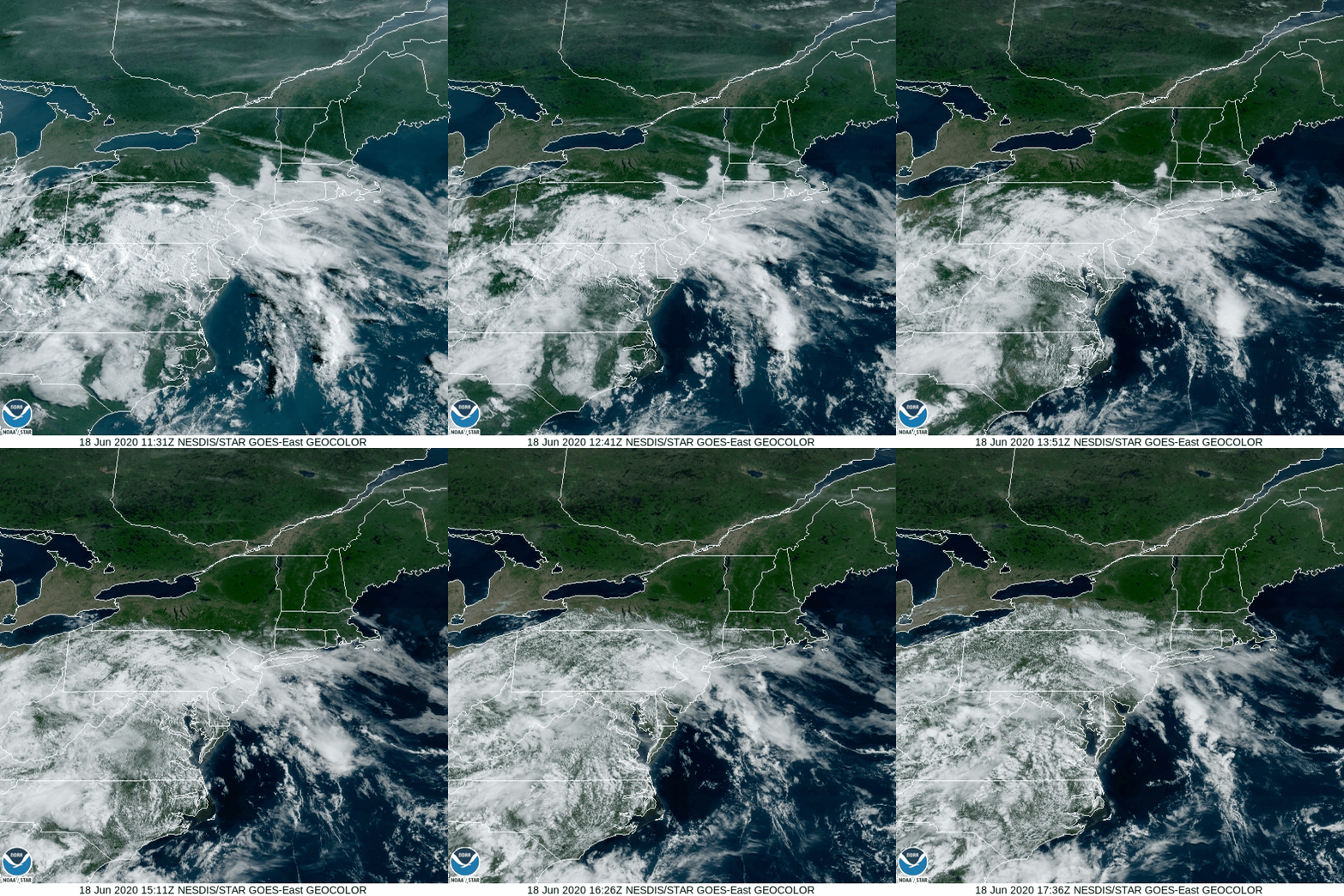
This morning’s satellite loop shows low clouds and fog burning off before high clouds move into the South Coast. Northern New England remains clear. Loop provided by NOAA.

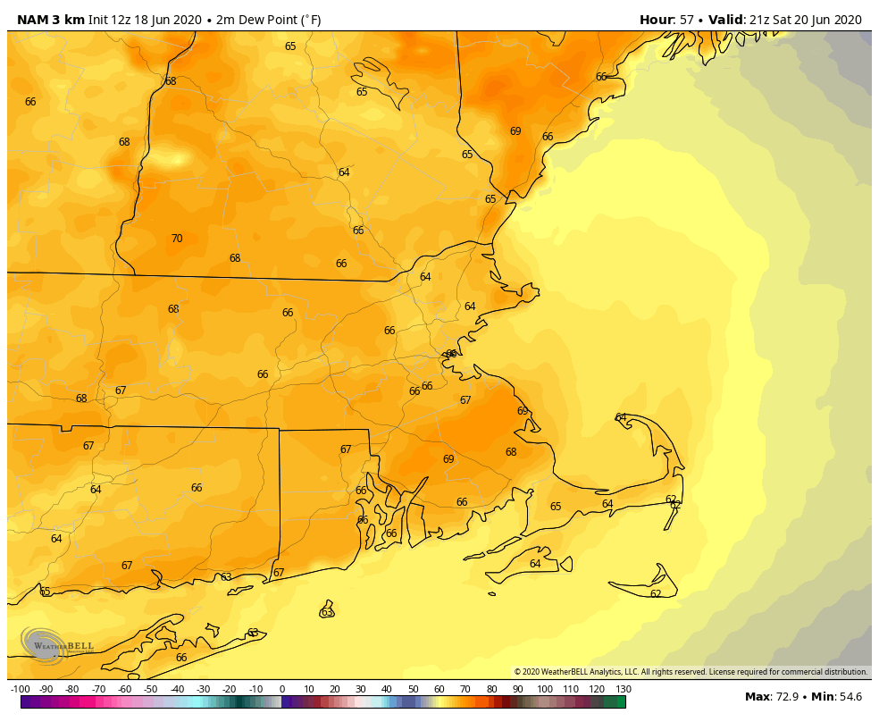
We’ll be brief today, because it’s really a very simple forecast. High pressure slides offshore, providing us with warm to hot and humid conditions for the next several days. Friday and Saturday look to be the hottest days, with temperatures topping 90 in some areas, especially from the Merrimack Valley into southern New Hampshire. Sunday and Monday will be a couple of degrees cooler, as we’ll have a bit more cloudcover, thanks to an upper-level low pressure area moving through. It may produce a few showers and thunderstorms, especially on Monday, but neither day should be a washout.

Dewpoints will be well into the 60s across the region for the next few days. Image provided by WeatherBell.

If you’re thinking of heading to the beach, bring the sunscreen. The UV Index will be in the very high range for the next few days, which means you’ll start to burn in just 15-20 minutes. High tides will be around midday for beaches on the east coast, while south coast beaches will have high tides in the morning, with a low tide around midday. Water temperatures are generally in the 60s right now. For those of you thinking about heading out on a boat, you’ll have southwest to south winds at 5-15 knots for the next few days, seas generally 1-3 feet, and aside from some patchy fog in the mornings, good visibility each day.

Thursday night: Clear to partly cloudy. Some low clouds and fog are possible along the south coast. Low 61-68.

Friday: Sunshine and a few clouds. High 86-93, cooler along the South Coast.

Friday night: Clear to partly cloudy. Low 61-68.

Saturday: Mostly sunny with a few afternoon fair-weather clouds, just a slight chance for an afternoon shower or thunderstorm, mainly across southern New Hampshire. High 87-94, cooler along the South Coast.

Saturday night: Clear to partly cloudy. Low 62-69.

Sunday: A mix of sun and clouds, a shower or thunderstorm is possible, but most of the shower activity should stay north and west of the area. High 84-91, cooler along the South Coast.

Sunday night: Partly cloudy. Low 61-68.

Monday: Partly sunny, some showers and thunderstorms are possible in the afternoon. High 83-90, cooler along the South Coast.