Tropical Storm Isaias is near the Carolina coastline this afternoon, but struggling to maintain its intensity.
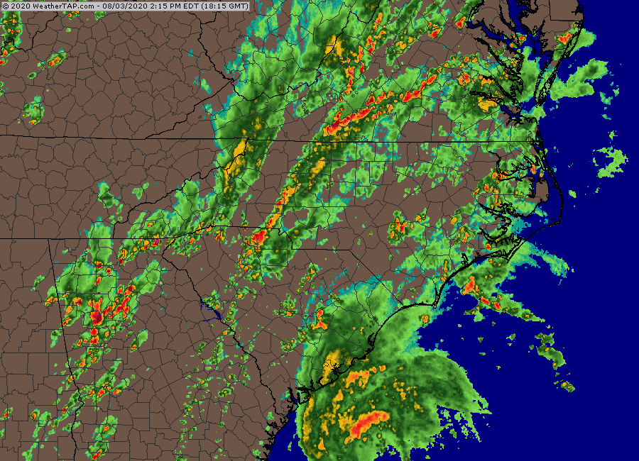
As of 2pm Monday, Tropical Storm Isaias was centered about 115 miles south of Charleston, South Carolina, moving toward the north at 13 mph, though radar and data from Air Force reconnaissance aircraft appear to show a motion more toward the north-northeast. The National Hurricane Center says maximum sustained winds are near 70 mph, but again, data from reconnaissance aircraft show the system to be weaker than that.
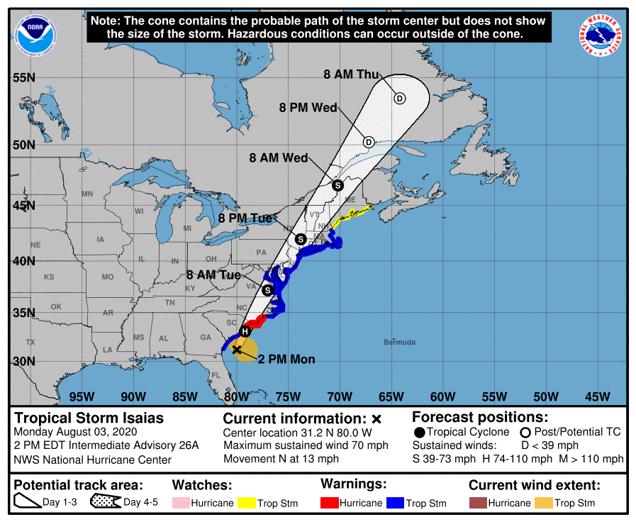
A Hurricane Warning is in effect from South Santee River, South Carolina to Surf City, North Carolina. A Storm Surge Warning is in effect from Edisto Beach, South Carolina to Cape Fear, North Carolina, and also from Oregon Inlet, North Carolina to the Virginia/North Carolina border, including Pamlico and Albemarle Sounds. Between Cape Fear and Oregon Inlet, a Storm Surge Watch is in effect. A Tropical Storm Warning is in effect south of South Santee River to Altamaha Sound, Georgia, and north of Surf City, all the way to the Mouth of the Merrimack River in Massachusetts, , including Chespeake Bay, the Tidal Potomac, River, Delaware Bay, and Long Island Sound. North of the Merrimack River, a Tropical Storm Watch is in effect to Eastport, Maine.
Isaias should continue heading north-northeastward, making landfall near the South Carolina/North Carolina border this evening. Although the official forecast calls for the storm to strengthen back into a hurricane before landfall, this appears unlikely at this point. There really isn’t much difference between a strong tropical storm and a weak hurricane anyway, so it’s a moot point. Once inland, it should continue on a north-northeast track, moving up the coastline, steered by an upper-level trough moving in from the west. Normally, tropical storms weaken rapidly as they move over land and away from warm water, which is their main source of energy. However, Isaias will be making the transition into an extratropical storm, so it may not weaken that rapidly.

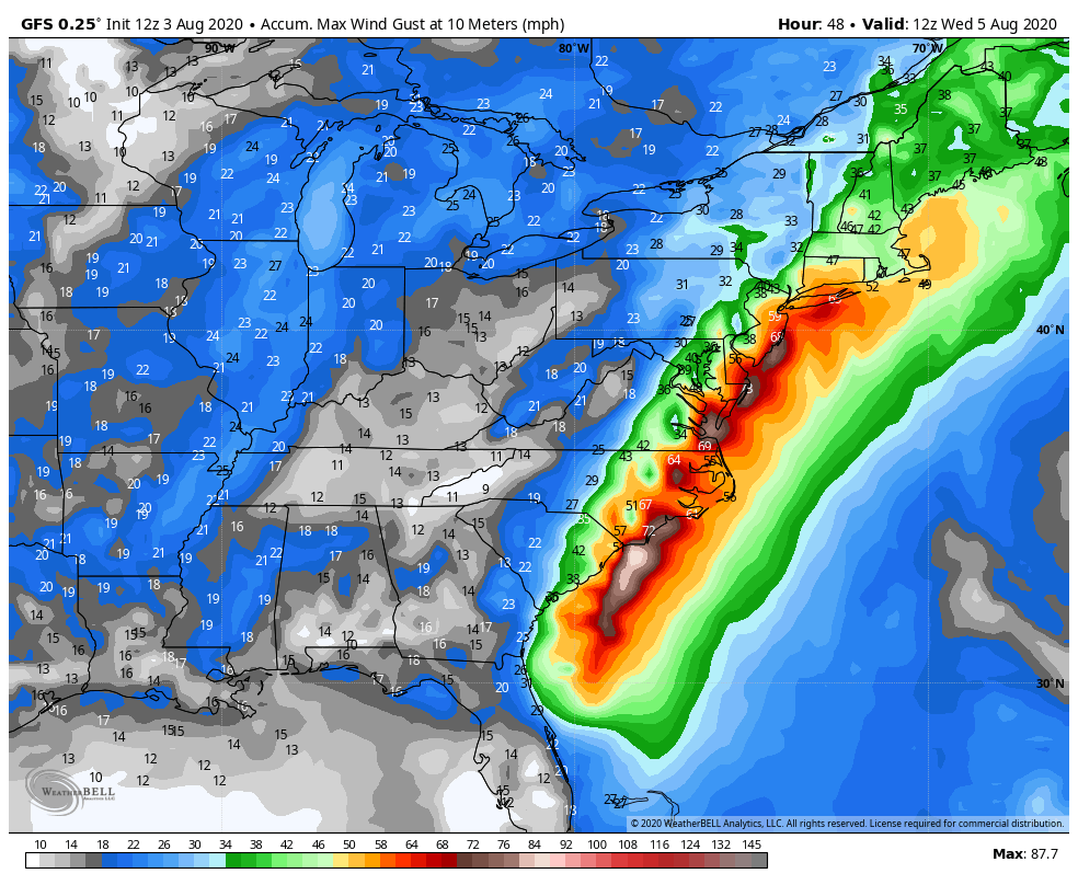
Storm surge will be a threat along the Carolina coast, near and east of where the center makes landfall. A surge of up to 5 feet above normal tide levels could result in some coastal flooding. Strong winds will also be a threat, mainly east of the storm’s center. Wind gusts of 40-50 mph have been reported just off the South Carolina coastline this afternoon. As it moves northward, some strong winds will be likely across eastern North Carolina as the storm moves inland, and possibly across eastern New England late Tuesday as the system moves across the Northeast.
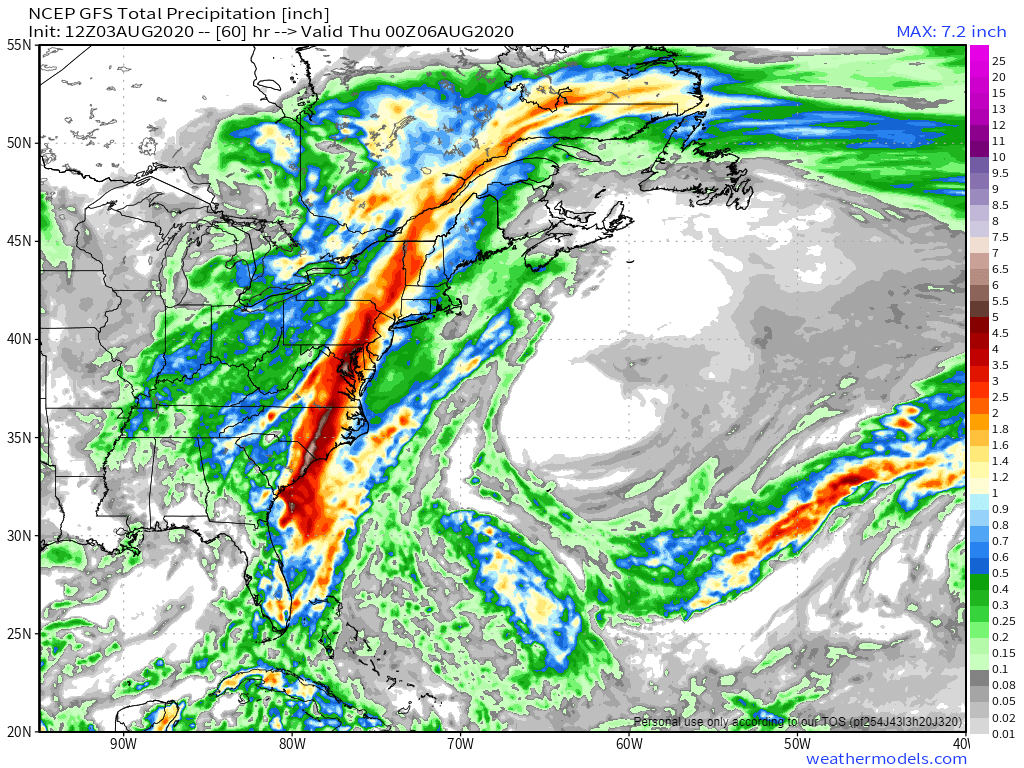
By far, the biggest threat with Isaias is heavy rainfall and the resulting flooding. The heaviest rain is likely along and west of the storm’s track. Rainfall totals of 3-6 inches and locally heavier are likely from the Carolinas into eastern Canada, which will produce flooding in many areas. The storm’s relatively quick motion will preclude even heavier totals. East of the storm’s track, rainfall will be much lighter, with many places likely seeing less than 1 inch, which won’t help with the drought developing across eastern New England.
Elsewhere, we’re keeping an eye on a tropical wave located a few hundred miles south of Bermuda. Conditions could become favorable for it to develop into a tropical depression in a few days. Model forecasts show it heading northwestward for the next few days, staying over open water. By mid-week, most forecasts show it stalling out about midway between Bermuda and the Bahamas. It does not look like a threat to any land areas at this time.
