Between the Atlantic and the Central Pacific Ocean we have three named storms, and all of them will threaten land areas this weekend.

We’ll start again with Tropical Storm Hanna, since it is the most immediate threat to land. As of 8pm EDT, the system was centered about 190 miles east-of Corpus Christi, Texas, moving toward the west at 10 mph. Maximum sustained winds were near 50 mph and additional strengthening is likely. Hanna could become a hurricane before making landfall in south Texas on Saturday. A Hurricane Warning is in effect for the Texas coast from Baffin Bay to Mesquite Bay, and a Storm Surge Warning is in effect from Baffin Bay to Sargent. A Tropical Storm Warning is also in effect from Baffin Bay southward to the mouth of the Rio Grande, and from Mesquite Bay northward to San Luis Pass.
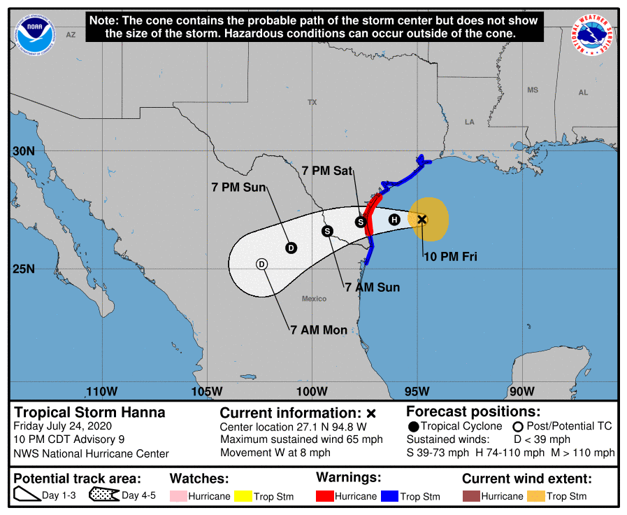
A storm surge of 2-4 feet is likely near and to the north of landfall. and strong winds are also likely near the coast and a short distance inland near landfall, but heavy rain and inland freshwater flooding remains the biggest threat with this system. Slow-moving tropical systems have produced significant rainfall in Texas many times before, and while we’re not expecting 50+ inches like Hurricane Harvey produced a few years ago, widespread totals of 6-12 inches with isolated amounts of up to 20 inches are possible through early next week. To the north, rainfall of 2-6 inches will likely cause flooding from Austin and San Antonio over to Houston.

While Hanna is the immediate threat to the US, out in the Atlantic, Tropical Storm Gonzalo is a threat to the southern Windward Islands. As of 8pm EDT, Gonzalo was centered about 340 miles east of the southern Windward Islands, moving toward the west at 18 mph. Maximum sustained winds have decreased to near 45 mph. Drier air has taken a toll on the system, and will continue to do so. A Tropical Storm Warning remains in effect for St. Vincent and the Grenadines, Tobago, and Grenada.

Gonzalo’s future remains very uncertain. The official forecast calls for Gonzalo to restrengthen a little over the next 24 hours, then weaken and dissipate after moving into the eastern Caribbean. However, at this point, it is just as like that it weakens and opens up into a wave before it crosses the islands on Saturday. No matter what it does, it will bring some squally weather to parts of the southern Windward Islands on Saturday. We’ll also need to keep an eye on what the remnants of the system do as they move across the Caribbean. Conditions in the western Caribbean could be a bit more favorable early next week and the water is plenty warm, so regeneration is not out of the question.

In the Central Pacific Ocean, Hurricane Douglas is starting to slowly weaken after peaking as a Category 4 Hurricane on Thursday. As of 8pm EDT, Douglas was centered about 725 miles east-southeast of Hilo, Hawaii, moving toward the west-northwest at 18 mph. Maximum sustained winds have decreased to 115 mph, making Douglas a Category 3 storm on the Saffir-Simpson scale. Some additional weakening is expected on Saturday as Douglas moves over cooler waters. A Hurricane Watch has been posted for Hawaii County and Maui County, including Maui, Lanai, Molokai, and Kahoolawe.
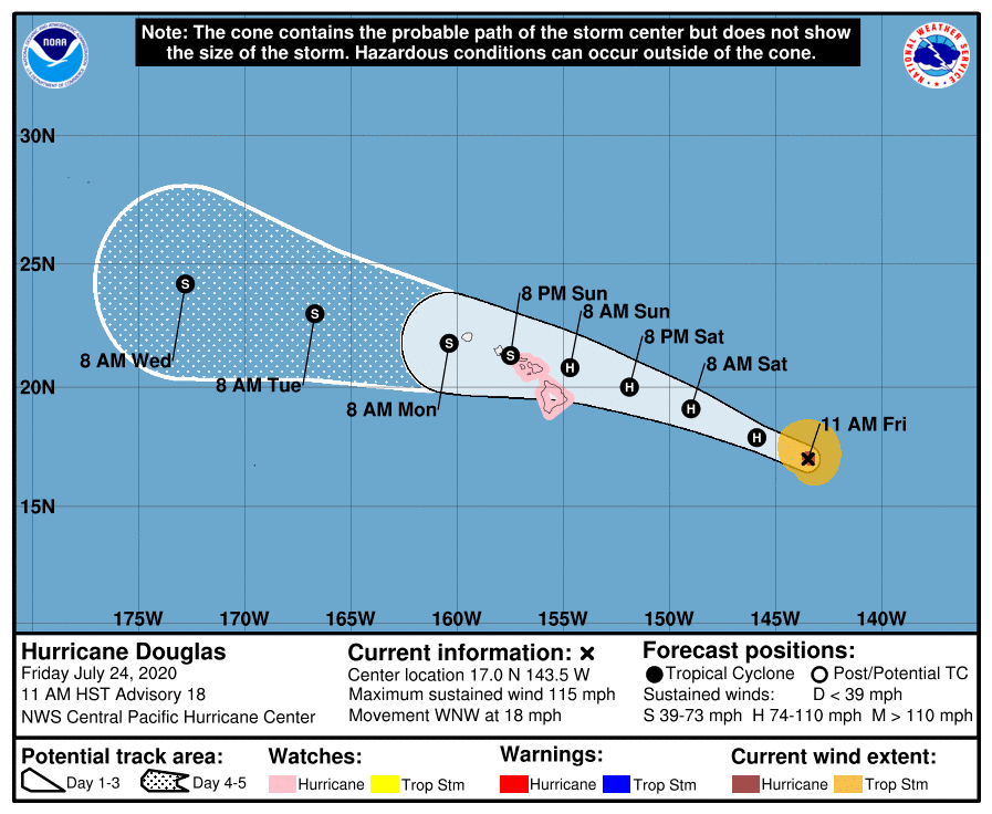
The forecast track for Douglas has shifted northward a bit over the past 24 hours, but still indicates the potential for Douglas to impact Hawaii as a weakening hurricane on Sunday, though some models keep the center north of the island chain completely. Rough surf, gusty winds, and heavy rainfall are likely across the islands starting late Saturday and continuing into Monday. Rainfall totals of 6-12 inches and locally up to 20 inches may cause flooding in some areas.
Finally, we’re keeping our eyes on a tropical wave in the eastern Atlantic Ocean. The wave isn’t that organized right now, but as it crosses the Atlantic, conditions could become more favorable for development. In fact, many models do show this developing into a tropical cyclone towards mid-week, and possibly becoming a threat to the eastern Caribbean by late next week. Model forecasts 5-7 days out aren’t terribly reliable, but there are some that show the system becoming a threat in about 10-12 days to anywhere from Central America to the Gulf to the East Coast, to Bermuda, to a system that passes harmlessly out to sea. In other words, it’s WAY to early to speculate about a system that hasn’t even formed yet. Yes, it’s something to watch, but that’s about it right now.
