Five Storms in the Atlantic

With the formation of Tropical Storm Vicky this morning, we now have a record-tying five storms in the Atlantic, and there may be another one coming soon.

The Atlantic remains active with 5 named storms this morning. Loop provided by NOAA.

The most immediate threat to the US is Tropical Storm Sally. Sally continues to slowly strengthen in the Gulf of Mexico. As of late Monday morning, Sally was centered about 185 miles southeast of Biloxi, Mississippi, moving toward the west-northwest at 6 mph. Maximum sustained winds were near 65 mph.

Forecast track for Tropical Storm Sally. Image provided by the National Hurricane Center.

Sally is expected to track northwestward across the northern Gulf of Mexico while strengthening later today into Tuesday. It will likely become a hurricane by tonight. Current forecasts call for landfall in either southeastern Louisiana or southern Mississippi on Tuesday. Hurricane and Storm Surge Warnings are in effect for much of the region. The location of landfall will have a significant impact on what conditions occur in some locations, namely storm surge. The highest storm surge is usually found near and to the right of where the center makes landfall. A landfall in southeastern Louisiana brings that storm surge to parts of the Louisiana coast and into Mississippi and Alabama. A track a bit farther east spares Louisiana from significant surge, but increases the threat to Mississippi, Alabama, and parts of the Florida Panhandle.
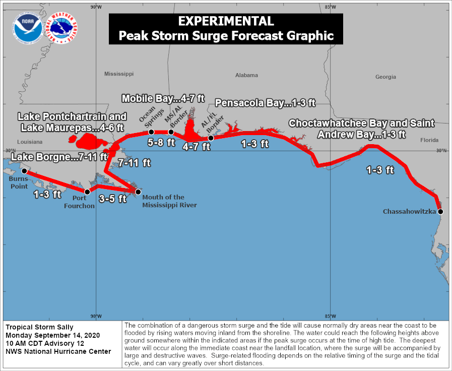
Significant storm surge is likely near and to the east of where the eye makes landfall.

While storm surge and strong winds are significant threats, rainfall will be the most significant issue residents of the Gulf Coast need to prepare for. Sally will be a slow-mover, and could even stall out near or just after landfall. We’ve seen plenty of slow-moving tropical systems dump torrential rainfall on places in recent years, and this system will likely do the same. Rainfall totals of 15-25 inches and possibly heavier will create widespread significant flooding. The heavy rain will also spread well inland, with flooding possible into parts of the Tennessee Valley later this week.

Torrential rainfall is likely along the Gulf Coast. Image provided by WeatherBell.

While Tropical Storm Sally is a threat to land, Hurricane Paulette impacted land earlier this morning, when it moved directly across the island of Bermuda. Paulette was centered about 65 miles north of Bermuda late this morning, moving toward the north at 14 mph. It has maximum sustained winds near 100 mph, and some additional strengthening is likely over the day or so as it turns more toward the northeast. Paulette is expected to head out into the open Atlantic over the next several days, presenting no additional threat to land.

Radar loop showing Hurricane Paulette approaching Bermuda Sunday night and early Monday. Loop provided by Brian McNoldy, Univ. of Miami, Rosenstiel School

In the central Atlantic, Tropical Depression Rene remains weak late this morning. It is centered about 1100 miles northeast of the Lesser Antilles, and maximum sustained winds have decreased to near 30 mph. Rene is expected to dissipate over open water in the next day or two.

Heading further eastward, we have Tropical Storm Teddy. As of late this morning, Teddy was centered about halfway between the Lesser Antilles and the Cabo Verde Islands. Maximum sustained winds were at 40 mph, and additional strengthening is likely. Teddy could become a hurricane by late Tuesday or Wednesday, and could strengthen into a rather potent storm by later this week. A turn toward the northwest should keep Teddy over open water, though residents of Bermuda should keep an eye on this storm, as it could present a threat to the island by late this weekend or early next week.
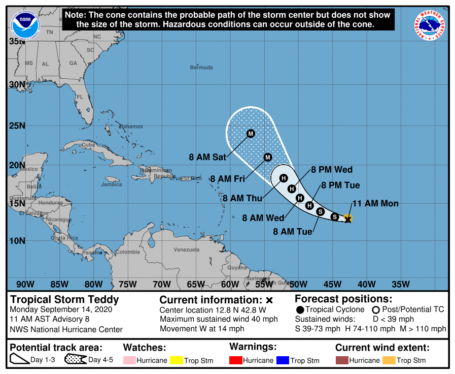
Forecast track for Tropical Storm Teddy. Image provided by the National Hurricane Center.

Even farther to the east, Tropical Storm Vicky developed this morning. As of late morning, Vicky was centered about 350 miles west-northwest of the Cabo Verde Islands, moving toward the northwest at 6 mph. Maximum sustained winds were near 45 mph. Vicky is expected to turn more toward the west over the next day or two while slowly weakening. It will likely dissipate over open water later this week.

Forecast track for Tropical Storm Vicky. Image provided by the National Hurricane Center.

With the formation of Vicky, we now have 5 named storms in the Atlantic. This ties the record for the most named storms at once, originally set between September 11-14, 1971. During September 11-12, 1971, there was also a short-lived tropical depression in the Atlantic, so we had 6 active tropical cyclones, a record that still has not been broken.

As if five storms wasn’t enough. Another tropical wave moved off the coast of West Africa today. Conditions may be favorable for some development over the next few days as it heads westward into the Atlantic.

Weekly Outlook: September 14-20, 2020

When will it rain? The simple answer is not anytime soon. Little to no significant rain is expected for a while.

The week starts off with high pressure building into the region today. We’ll have a relative warm day, but northwest winds will start to usher cooler air into the region by late afternoon and evening. With the high moving across the region for Monday night and Tuesday, temperatures should be much cooler. The high then slides offshore, so we’ll start to warm back up again for Wednesday and Thursday.

Tuesday morning could be quite chilly, especially well north and west of Boston. Image provided by WeatherBell.

A cold front will approach the region late Thursday into Friday, producing a few showers. The wild card with this front is the remnants of Sally. If they get pulled far enough north, they could enhance the rainfall with the cold front, especially along the South Coast. However, the models don’t agree on how far north they will get. Given how the spring and summer have gone, we’re going to lean on the dry side again. High pressure then builds in for next weekend with cool and dry conditions.

Very little rainfall is expected over the next 10 days across the region. Image provided by Weathermodels.com

Two things to also take note of for the next few days. With Hurricane Paulette in the Atlantic, we’ll have some rough conditions at the beaches, especially along the south coast, for a few days. High Surf Advisories are currently in effect through Tuesday evening. Also, with the fires out west, some of the smoke will make its way here, creating some hazy conditions at times, and some brilliant sunrises and sunsets.

Monday: Becoming mostly sunny and breezy. High 71-78.

Monday night: Clear and cool. Low 41-48, a little warmer in the urban areas.

Tuesday: Sunshine and a few clouds. High 62-69.

Tuesday night: Clear skies. Low 45-52.

Wednesday: Mostly sunny, breezy, and milder. High 72-79.

Thursday: A mix of sun and clouds, chance for a few showers at night. High 75-82.

Friday: Chance for an early shower, then becoming partly to mostly sunny. High 62-69.

Saturday: Mostly sunny. High 59-66.

Sunday: Partly sunny. High 59-66.

The Peak of Hurricane Season is Here

On average, the peak of hurricane season in the Atlantic is the middle of September. Right on cue, the 2020 season has seen a significant uptick to activity, with three active systems, a fourth likely to form in the next day or so, and possibly a fifth one a few days from now.

Tropical activity is picking up across the Atlantic. Loop provided by NOAA.

The most immediate threat to the US is Tropical Storm Sally. Tropical Depression 19 formed Friday evening just off the coast of southeastern Florida. The center of the system moved inland last night just south of Miami, producing wind gusts of up to 50 mph and heavy rain across south Florida. Early Saturday afternoon, the depression had strengthened into Tropical Storm Sally, and was centered about 35 miles south-southeast of Naples, Florida, moving toward the west at 7 mph. Maximum sustained winds were near 40 mph.

Tropical Storm Sally will head towards the northern Gulf Coast over the next few days. Image provided by Weathermodels.com

Sally is expected to track northwestward across the Gulf while strengthening over the weekend. It could become a hurricane by Monday. Current forecasts call for landfall in either southeastern Louisiana or southern Mississippi by early Tuesday. While storm surge and strong winds will obviously be a threat, rainfall will be the most significant issue residents of the Gulf Coast will need to prepare for. Sally will be a slow-mover, and could even stall out near or just after landfall. We’ve seen plenty of slow-moving tropical systems dump torrential rainfall on places in recent years, and this system will likely do the same. Rainfall totals of 10-20 inches and possibly heavier will create widespread significant flooding.

Torrential rainfall will produce flooding across parts of the Gulf Coast early next week. Image provided by WeatherBell.

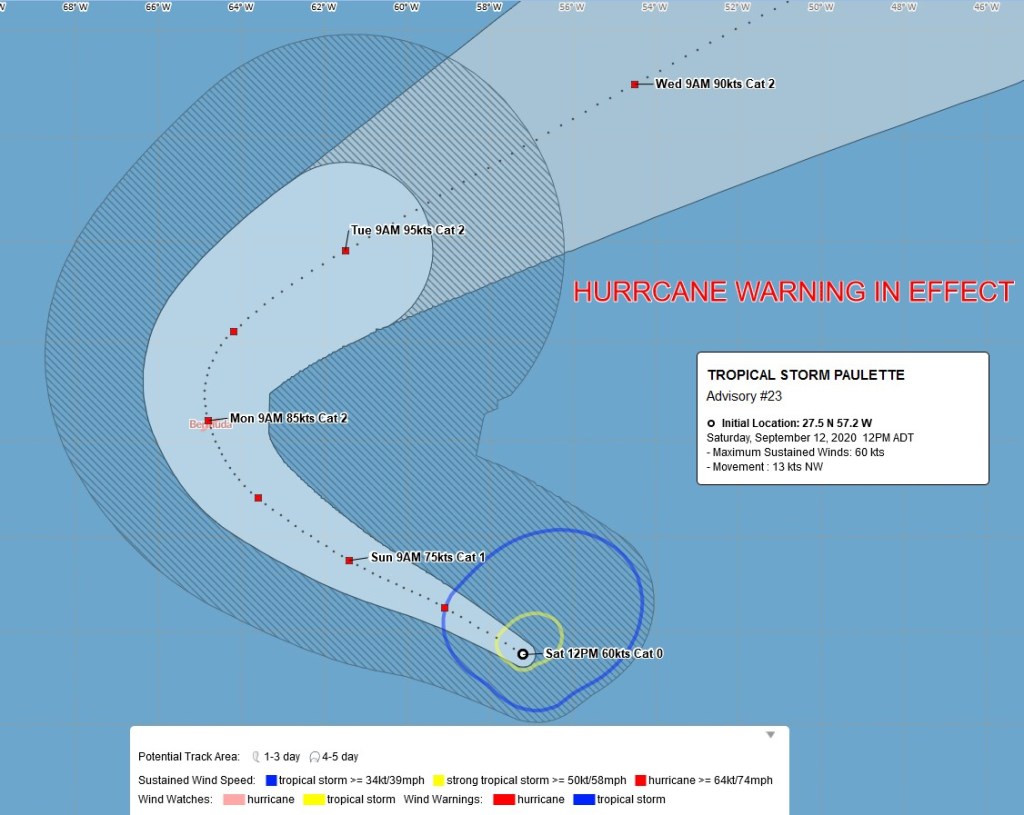
Tropical Storm Sally isn’t the only storm that is threatening land at this time. Tropical Storm Paulette is centered about 510 miles southeast of Bermuda this afternoon, moving toward the northwest at 15 mph. It has maximum sustained winds near 70 mph, and it will likely become a hurricane later today or tonight. Additional strengthening is likely over the next couple of days as the storm continues northwestward before turning more toward the north. Unfortunately, that northerly turn will happen right around the time that Paulette reaches Bermuda’s longitude. A hurricane warning has been issued for Bermuda. Current forecasts call for the storm to pass very close to or right over the island late Sunday night and early Monday as a Category 2 hurricane. Paulette will also bring large waves to parts of the East Coast over the next several days, increasing the threat for rip currents at the beaches.

Forecast track for Tropical Storm Paulette. Image provided by the Bermuda Weather Service.

Bermuda is no stranger to tropical cyclones, as they are impacted by one per year on average. Last year, Hurricane Humberto produced wind gusts in excess of 120 mph on the island when the center passed just to the northwest. The last hurricane to make landfall in Bermuda was Hurricane Nicole in 2016. The only other storms to move directly across Bermuda in the 30 years before Nicole were Hurricane Fabian in 2003 and Hurricane Emily in 1987. One element of hurricanes that Bermuda doesn’t have to worry about is storm surge. Because the island is essentially a peak in the middle of the ocean, the water doesn’t have time to build up approaching the coast. The reef surrounding the island also helps to disperse some of the water before it reaches land. Humberto was a Category 3 storm that passed just northwest of the island last year, but only produced a storm surge of 2-3 feet. A similar storm impacting the US could produce a storm surge of 10-15 feet on average.

Forecast track for Tropical Depression Rene. Image provided by the National Hurricane Center.

In the eastern Atlantic, Tropical Depression Rene is slowly weakening this afternoon. It is centered about 1250 miles east of the Lesser Antilles, and maximum sustained winds have decreased to near 35 mph. Rene is expected to remain weak while meandering around in the central Atlantic for the next few days. Conditions won’t be that favorable, and it will likely dissipate over open water by early next week.

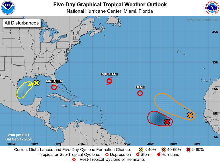
In addition to the 3 active systems, there are several other areas being watched for development this afternoon. Image provided by the National Hurricane Center.

Even farther to the east, there are two other systems that are being monitored at this time. The first system is several hundred miles southwest of the Cabo Verde Islands this afternoon. This system will likely become a tropical depression in the next 12-24 hours. It should continue across the Atlantic with some gradual strengthening likely over the next several days. It will not impact any land areas for at least another 5 or 6 days, if at all. Some of the models show the potential for this to become a significant storm, so we’ll keep an eye on it.

Forecast models show the potential for 2 more systems to develop in the eastern Atlantic. Image provided by the University at Albany.

Another area of disturbed weather is crossing the Cabo Verde Islands this afternoon. It will bring squally conditions to the islands today and tonight. There is some potential for this system to develop over the next few days as well. Once it moves past the islands, it will likely not be a threat to any land areas.

Weekend Outlook: September 11-14, 2020

At the risk of sounding like a broken record – we need rain, quite a bit of it in fact. We’ll get a little this weekend, but not much.

We’re getting some rain today and tonight as a cold front moves in from the northwest and a stream of tropical moisture moves up from the south. While some of this rain may be heavy, the bulk of the heavy rain won’t impact much of the region. The rain should end tonight from northwest to southeast as the cold front pushes through and then offshore.

The longer we go without significant rain, the worse the drought gets. Image provided by the National Drought Mitigation Center.

Behind the front high pressure builds in on Friday with much cooler and less humid conditions. This is the same airmass the produced record lows across the nation’s mid-section over the past few days, but obviously, it will be modified significantly by the time it arrives here. Still, highs will only be in the upper 60s and 70s on Friday and Saturday, with nighttime lows dropping into the 40s in some spots.

Normal low temperatures for the middle of September are in the lower to middle 50s. Image provided by Weathermodels.com

By Sunday, we’ll start to warm up again as another cold front approaches from the west. This front will produce some showers and maybe a rumble of thunder, but the day won’t be a washout, as most of the shower activity should hold off until late in the day or at night. Some of the models are hinting at the possibility of some heavy rain with this front, but we’re not buying that at the moment. Of course, many of us will be on our couches Sunday afternoon watching the start of the NFL season. For the Patriots game, kickoff conditions should feature mostly cloudy skies, temperatures in the lower to middle 70s, and southerly winds at 5-10 mph with gusts to 20 mph. Any rain should hold off until after the game.

The Cam Newton Era will begin under mostly cloudy skies on Sunday.

Any showers will comes to an end Monday morning as the front moves through, then skies will clear out once again. Gusty northwest winds will usher cooler air back in, but most of the day should remain fairly mild.

At least one model thinks parts of the region may receive no rain at all Sunday night or Monday. Image provided by WeatherBell.

Thursday night: Periods of rain and showers gradually ending. Low 58-65.

Friday: Skies gradually become partly to mostly sunny. High 67-74.

Friday night: Clear to partly cloudy. Low 47-54, a little warmer in some of the urban areas.

Saturday: Mostly sunny, though some clouds may start to move in late in the day. High 65-72.

Saturday night: Becoming partly to mostly cloudy. Low 48-55, a little warmer in some of the urban areas.

Sunday: Mostly cloudy, showers develop late in the day. High 70-77.

Sunday night: Cloudy with a chance of showers, possibly a rumble of thunder. Low 60-67.

Monday: Showers end early, then skies gradually clear out, breezy. High 72-79.

Record Heat and Cold, Snowstorms, Droughts, and Tropical Storms – What’s Next?

September is when we start to transition from Summer to Winter, but this September is starting off with a bang.

Intense heat has been common across much of the West for the past few days. Temperatures well over 100 degrees were widespread during Labor Day Weekend, especially across California, with numerous records set. One location, Richmond, on the eastern side of San Francisco Bay, reached 107 degrees Monday afternoon, tying their all-time record, originally set on September 15, 1971. Several other locations set monthly records for September as well. The worst of the heat has passed, but it will remain hot on Tuesday, with highs likely topping 100 across much of interior California and the Desert Southwest, possibly setting a few more records. Temperatures should gradually cool down a little more as we get toward the middle and latter portion of the week.

Another hot day is likely across interior California on Tuesday. Image provided by WeatherBell.

Heat was also common across the Plains and Rocky Mountains over the weekend, but big changes are developing thanks to a strong cold front. Denver set a record high of 97 on Sunday, then reached 93 on Monday. On Tuesday, that 93 will get reversed, with a daytime high closer to 39 (The high for the calendar day will be the 46-degree reading at midnight). On top of that, accumulating snow is likely. Even by Denver standards, this is quite early in the year for snow. Their all-time record for earliest snow is September 3, 1961, but on average Denver doesn’t see its first flakes until October 18. This won’t be the 1st time that Denver hit 90 one day and then had measurable snow the next. On September 12, 1993, Denver recorded a high of 92 degrees, and on September 13, they had 5.4″ of snow.

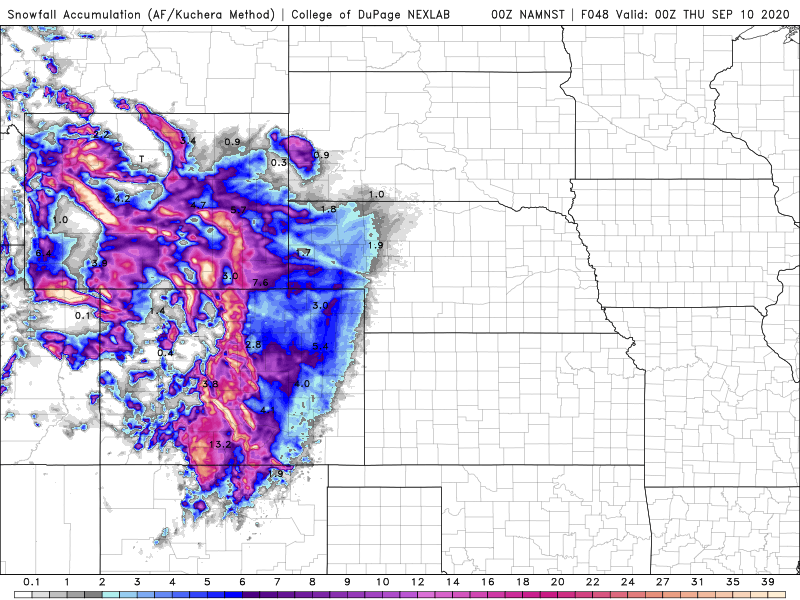
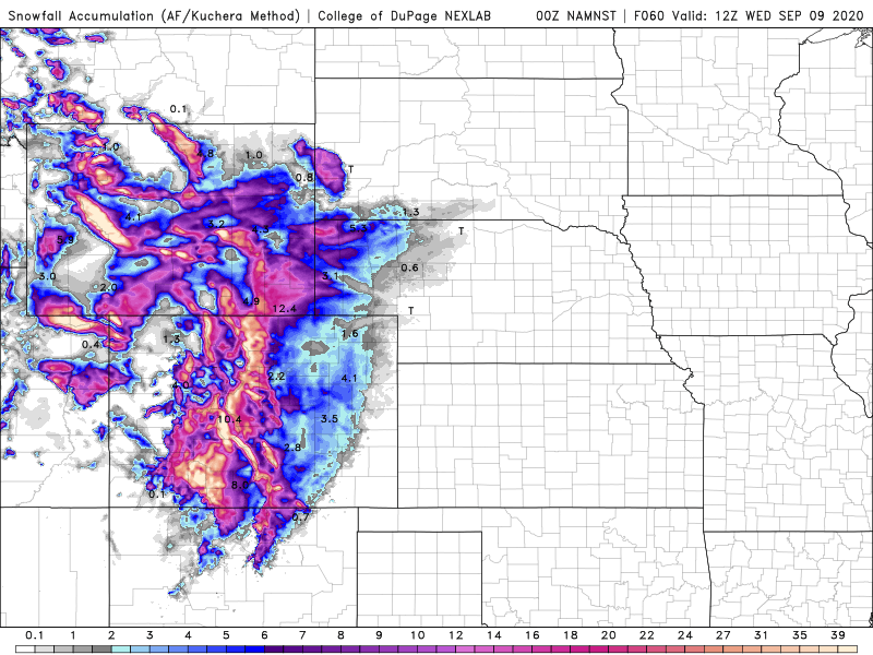
While a few inches of snow are likely in Denver and onto the adjacent High Plains of eastern Colorado and western Nebraska, heavier snow is likely across the mountains on Colorado and Wyoming. Across the higher elevations, snowfall totals in excess of a foot are likely. While the snow will likely last a while in the mountains, at the “lower” elevations on the Plains, it will disappear quickly. High temperatures in Denver will be back into the 60s by Friday, and near 80 by the end of the weekend.

Heavy snow is likely in the higher elevations of the Rockies. Image provided by the College of DuPage.

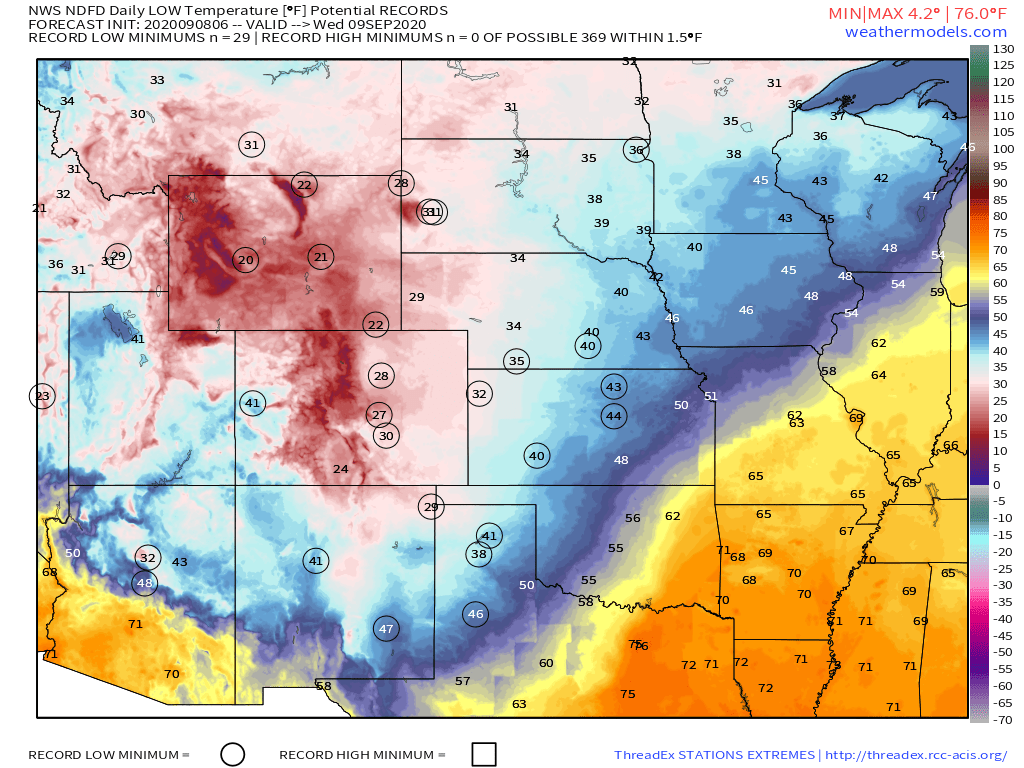
While the snow will get a lot of the headlines, the cold air behind the front will be making headlines of its own. The first frost and freeze of the season is likely across parts of the Dakotas, Montana, and northern Minnesota Tuesday and/or Wednesday morning, with lows in the upper 20s and 30s. The cold air will continue to push southward across the Great Plains during the day on Tuesday, with numerous record lows expected Wednesday morning as far south as the Texas Panhandle. The cold air will eventually spread eastward, but will be modified significantly before it reaches the Eastern United States.

Record lows are likely across the Plains and the Rockies Wednesday morning. Image provided by Weathermodels.com

While plenty of (frozen) precipitation is expected across the Rockies, the lack of precipitation is causing problems across the Northeast, specifically New England. Aside from a few showers with a cold front on Thursday, generally dry weather is expected across much of New England this week, and things don’t look that promising for much of next week either. This shouldn’t be a surprise, as precipitation has been generally below to well below normal across the region since the Spring. In some areas, the amount of rain has only been around 50-60% of normal since April 1. Drought conditions have developed across nearly all of New England, and for a good portion of the region, it is now considered a severe drought. What the region needs is a series of systems that can produce moderate rainfall to help alleviate the drought (too much at once won’t help that much), but prospects for that aren’t promising at this time. In fact, rainfall looks to remain below normal for much of the remainder of September.

Drought conditions are worsening across New England. Image provided by the National Drought Mitigation Center.

Meanwhile, as we approach the climatological peak of hurricane season, the Atlantic is once again getting more active. Tropical Storms Paulette and Rene both developed on Monday in the central and eastern Atlantic respectively. Paulette is expected to remain a tropical storm for the next several days while remaining over open water. It is not expected to be a threat to land. Meanwhile, Tropical Storm Rene moved into the Cabo Verde Islands Monday night and early Tuesday, producing heavy rain and gusty winds. It will likely strengthen over the next couple of days, possibly becoming a hurricane later this week. Once it pulls away from the Cabo Verde Islands, it is also expected to remain over open water for much of this week, presenting no additional threat to land.

Satellite loop showing Tropical Storms Paulette and Rene in the central and eastern Atlantic. Loop provided by Tropical Tidbits.

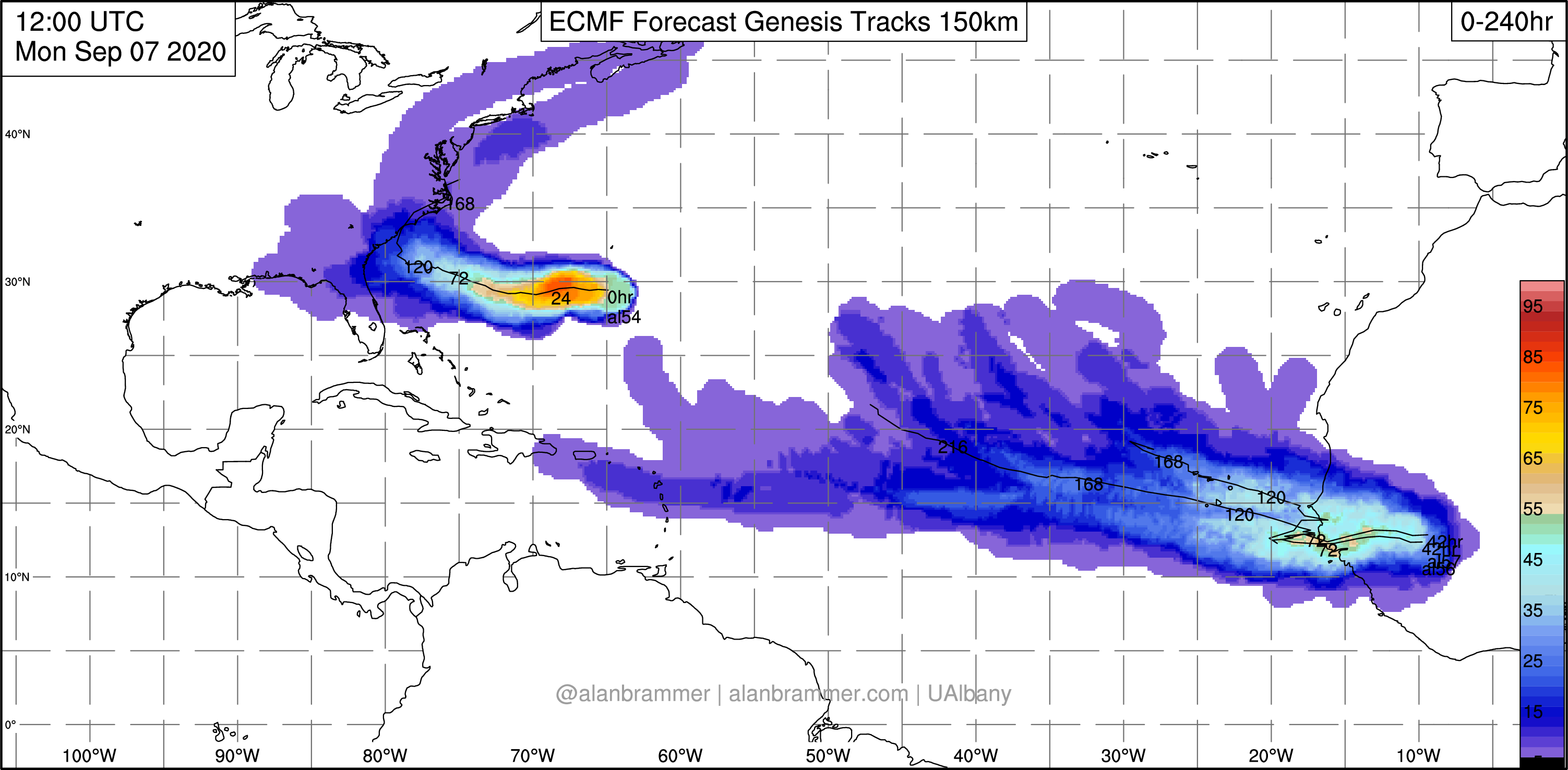
Those systems aren’t the only ones in the Atlantic that are being watched. An area of low pressure a couple of hundred miles west-southwest of Bermuda is expected to drift westward or northwestward over the next day or two. Some development of the system is possible. It may bring some rainfall into parts of the Carolinas and Southeast later this week. The other area that is being watched isn’t immediately apparent right now, as it is still over western Africa. A tropical wave is expected to emerge from the west coast of Africa later this week. Forecast models show the potential for this wave to develop rather quickly once it moves into the Atlantic. It could threaten the Cabo Verde Islands over the weekend.

The peak of hurricane season is during the middle to latter half of September. Given how active this season has been so far, there will likely be more systems developing. There are only 4 names left on this list for this season – Sally, Teddy, Vicky, and Wilfred. Once the list is exhausted, the Greek alphabet is used. This has only happened once before – in 2005. During that season, there were 28 named storms of which 15 became hurricanes.

Weekly Outlook: September 7-13, 2020

The late great Dick Albert loved to used abbreviations on his forecasts maps, and we’re going to invoke one of his more common ones for this week’s forecast – MOTS (More Of The Same).

Stop us if you heard this before – we’ll start the week with high pressure in control, providing us with ideal cookout weather for Labor Day – sunshine, warm temperatures, and moderate humidity. As the high slides off to the east, temperatures and humidity levels will creep up a bit for Tuesday and Wednesday.

On average, high temperatures should be in the middle 70s for the middle of September. Image provided by Weathermodels.com

We’ll have a cold front move across the region on Thursday, bringing us some showers and thunderstorms, but right now they don’t look that heavy, so the drought we’re in will likely continue to worsen. High pressure builds in behind that front with cooler and drier conditions for Friday and Saturday. Sunday doesn’t look as good, with clouds and some showers possible, but given the recent performance by the models beyond a few days, we’re skeptical as to how wet it will be. We should have a better idea by the time we get to our Weekend Outlook on Thursday.

While we may see some rain on Thursday and possibly Sunday, we’re not expecting a lot. Image provided by WeatherBell.

Monday: Sunshine and plenty of it. High 75-82.

Monday night: Clear to partly cloudy. Low 57-64.

Tuesday: Partly to mostly sunny. High 80-87.

Tuesday night: Partly cloudy. Low 59-66.

Wednesday: A mix of sun and clouds. High 80-87.

Thursday: More clouds than sun with some showers or thunderstorms possible. High 79-86.

Friday: Becoming partly to mostly sunny and much cooler. High 68-75.

Saturday: A mix of sun and clouds. High 67-74.

Sunday: Mostly cloudy with a chance of showers. High 71-78.

On a separate note, while our weather has been, and will continue to be fairly quiet, there is some wild weather going on in other parts of the nation. Much of California and the Southwest has been baking in some extreme heat over the weekend. San Francisco set a record high when it reached 100 downtown yesterday and 102 at the airport. The normal high for the day is only 74. Even wilder weather will invade the Rockies and the Plains in the coming days. Denver reached 97 yesterday, tying their record for the day. They should reach 90 again on Monday ahead of a strong cold front. Behind that front, they could receive 6 or more inches of snow on Tuesday. Denver’s record for earliest snow on record is September 3, 1961. On average, they don’t see snow until October 18. In the higher elevations of the Rockies, snowfall totals 1-2 feet or more are possible.

A significant snowstorm is likely in the Rockies tonight and Tuesday. Image provided by the College of DuPage.

We also have a new tropical depression in the Atlantic. Tropical Depression 17 developed last evening. It will likely become Tropical Storm Paulette today, but will remain over open water for the next several days, presenting no threat to land. Another wave in the eastern Atlantic could become a tropical depression or storm in the next day or two as well. The climatological peak of hurricane season is still about 10-14 days away, so the uptick in activity is not a surprise at all.
Labor Day Weekend Outlook: September 4-7, 2020

Labor Day Weekend is the “traditional” end to summer, and this one will be a lot like most of the summer has been – dry.

Yes, we’ll say it again – we really need some rain. Image provided by the National Drought Mitigation Center.

This forecast will be fairly brief, because there’s not a lot to talk about. A cold front moves through tonight, bringing an end to the showers we’ll have this afternoon and evening. High pressure then builds in for Friday and the weekend. Friday will remain quite warm, but noticeably less humid. We’ll cool off a bit for Saturday, but then we’ll start to warm up again for Sunday and Monday, with humidity levels starting to creep up once again.

High temperatures should be well into the 80s across the region on Friday. Image provided by WeatherBell.

Thursday night: Any lingering showers come to an end, the skies start to clear out late at night. Low 63-70.

Friday: Becoming mostly sunny. High 80-87.

Friday night: Clear to partly cloudy. Low 52-59.

Saturday: Sunshine and a few clouds. High 70-77.

Saturday night: Clear to partly cloudy. Low 52-59.

Sunday: A mix of sun and clouds. High 74-81.

Sunday night: Clear to partly cloudy. Low 55-62.

Labor Day: Partly to mostly sunny. High 76-83.

Weekly Outlook: August 31-September 7, 2020

As we close the book on Meteorological Summer and welcome in Meteorological Autumn, we’ll have some summer-like weather for at least part of the week.

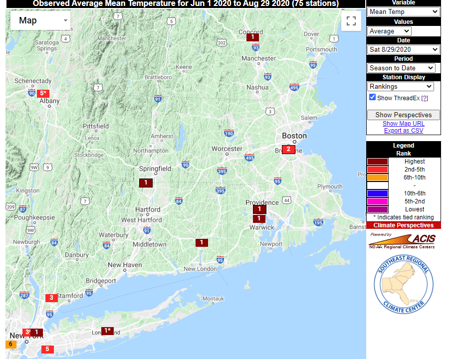
Despite a lack of extreme heat, this will still go down as one of the warmest summers on record across the region. Image provided by the Southeast Regional Climate Center.

We start the week off with high pressure in control, providing us with a dry but cool Monday. It won’t be nearly as breezy as Sunday was as the high moves right across the region. Tuesday and Wednesday will both feature some clouds, with a chance for a few showers as a pair of upper-level disturbances move through, but we’re not expecting widespread rainfall. At the same time, low pressure will pass well south of New England. Since it will almost certainly contain at least 1 thunderstorm, and the system itself will probably be rotating, the National Hurricane Center will probably name it. We shouldn’t have anything to worry about here, though it may result in some increasing wave action along the South Coast towards midweek.

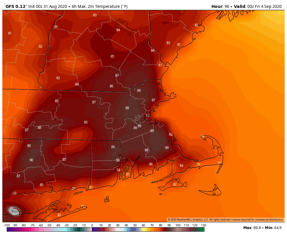
By Thursday, things start to change. We’ll turn warmer and more humid thanks to a southwest flow ahead of a cold front. Some places could make a run at 90, which is actually fairly normal for early September. With the warm and humid air comes a better chance for showers and thunderstorms. The cold front itself moves through early Friday, with drier air settling in behind it, though it will likely remain warm.

Temperatures could approach 90 across parts of the area on Thursday. Image provided by WeatherBell.

High pressure returns on Saturday with cooler and dry conditions to kick off Labor Day Weekend. As the high slides offshore we’ll start to warm up again on Sunday. As for Labor Day itself, it looks like another cold front will approach, with some showers and thunderstorms possible, but we’ll fine-tine that outlook later this week.

Monday: Sunshine and some afternoon high clouds. High 69-76.

Monday night: Clear to partly cloudy. Low 51-58.

Tuesday: A mix of sun and clouds, slight chance for a few afternoon showers. High 70-77.

Tuesday night: Partly cloudy. Low 57-64.

Wednesday: Intervals of clouds and sun, some showers may develop during the afternoon. High 72-79.

Thursday: Partly sunny, showers and thunderstorms develop during the afternoon, ending overnight. High 80-87.

Friday: A mix of sun and clouds. High 81-88.

Saturday: Plenty of sunshine. High 71-78.

Sunday: Mostly sunny. High 73-80.

Monday: Becoming cloudy with showers and thunderstorms possible during the afternoon and evening. High 74-81.

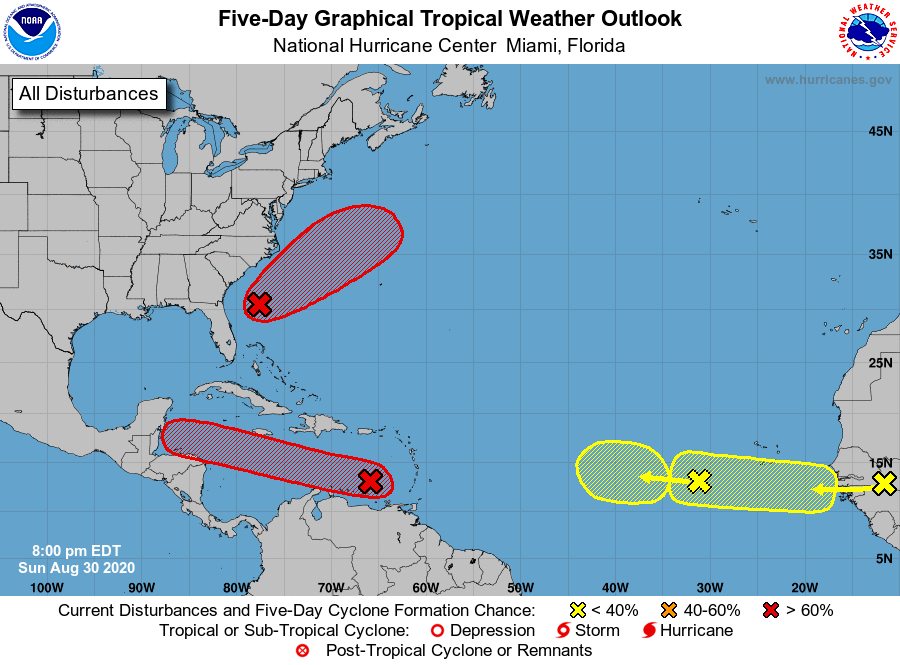
The Atlantic is showing signs of waking up once again. Image provided by the National Hurricane Center.

One final thought on this final day of Meteorological Summer. The weather patterns across the US are starting to change as we head into a new season. Much cooler air will invade the Rockies and the Plains States later this week and likely linger into next week. Some light snow is possible in parts of Idaho, Montana, and Wyoming, mainly at elevations above 9000 feet. Meanwhile, there are several areas in the tropics being monitored as you can see in the graphic above. In addition to the system that will pass well south of us, another system in the Caribbean could become a tropical depression and may bring some heavy rain to central America later this week. The parade of tropical waves continues to come off the African coast, and any of those could develop as they cross the Atlantic, though nothing appears imminent. So, even though we’re about the begin autumn, there are elements of both summer and winter showing up across our portion of the world.

Weekend Outlook: August 28-31, 2020

We’ve reached the final days of not only August, but meteorological summer, and some of them may not feel like summer.

A warm front will get hung up to our south today, keeping most of the severe weather well south and west of us. In fact, it’ll stay far enough south that high pressure will build in for Friday. This will bring us some sunshine and milder temperatures. However, this dry weather will be short-lived.

Another system will approach on Saturday, bringing some showers and possibly some thunderstorms into the region. We may be dealing with a situation similar to today where a warm front struggles to move into the region, which could keep some areas on the cool side. This front looks to have at least a little more push than today’s as the parent low will likely move across Northern New England, but we’ll have to see keep an eye on it.

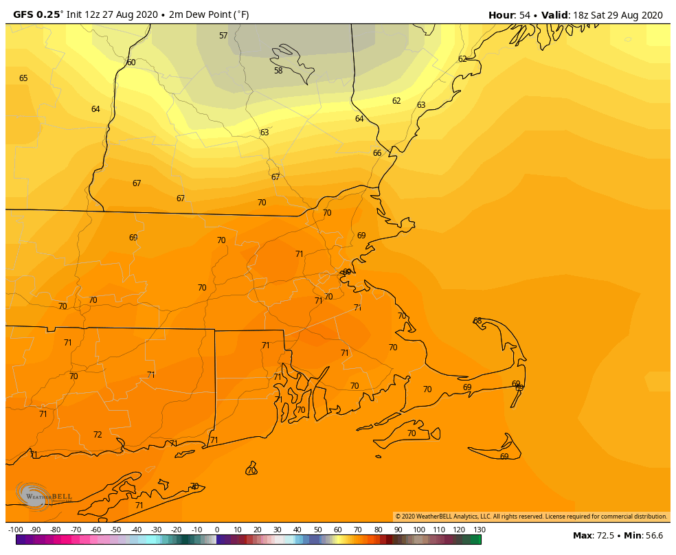
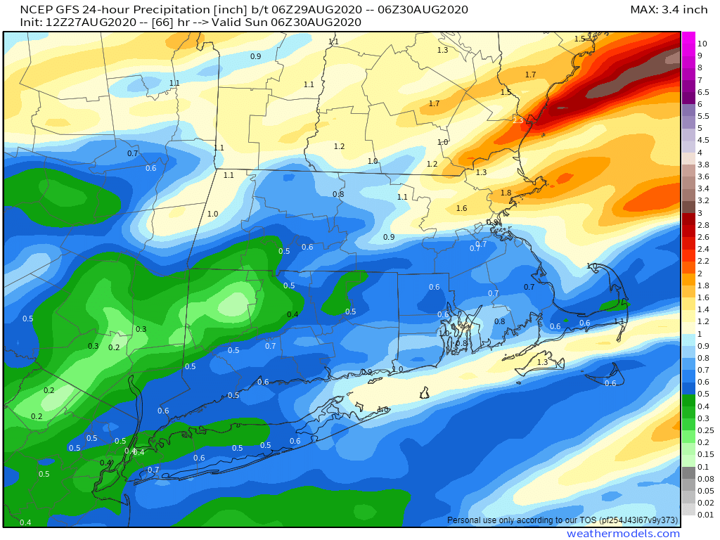
Complicating things even more will be the remnants of Laura moving off the Mid-Atlantic coastline and passing south and east of New England. Laura won’t be tropical any more, but as the system moves back out over water, it may start to strengthen a little bit as an extratropical system. If it is far enough north, some of the moisture from it could stream northward as a cold front moves across the region. This could enhance the rainfall, making for a very wet time late Saturday and Saturday evening, especially along the South Coast.

Saturday’s system could bring some much-needed rainfall to the region. Image provided by Weathermodels.com

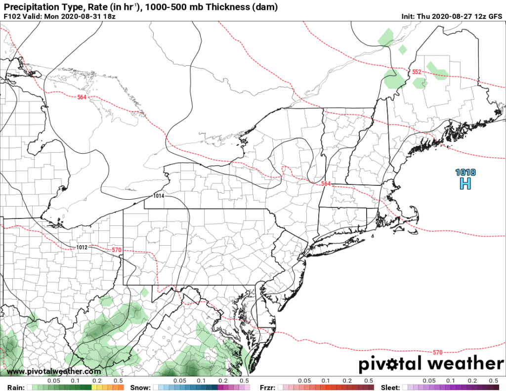
Once the cold front moves offshore Saturday night, high pressure will build back in for Sunday and Monday. This will bring a return to sunshine and seasonably mild conditions for the final days of August.

High pressure brings in dry and seasonably mild air for Sunday and Monday. Image provided by Pivotal Weather.

Thursday night: A few showers or thunderstorms along the south coast during the evening, otherwise becoming clear to partly cloudy. Low 55-62, possibly a little cooler across southern NH and the NH Seacoast.

Friday: Partly sunny. High 77-84.

Friday night: Clouds return with showers developing after midnight. Low 60-67.

Saturday: Cloudy with periods of showers and thunderstorms. High 75-82.

Saturday night: Showers and thunderstorms end in the evening, then skies clear out towards daybreak. Low 59-66.

Sunday: Partly to mostly sunny. High 72-79.

Sunday night: Clear skies. Low 50-57.

Monday: Sunshine and a few clouds. High 70-77, coolest along the coast.

Laura Bears Down on the Gulf Coast

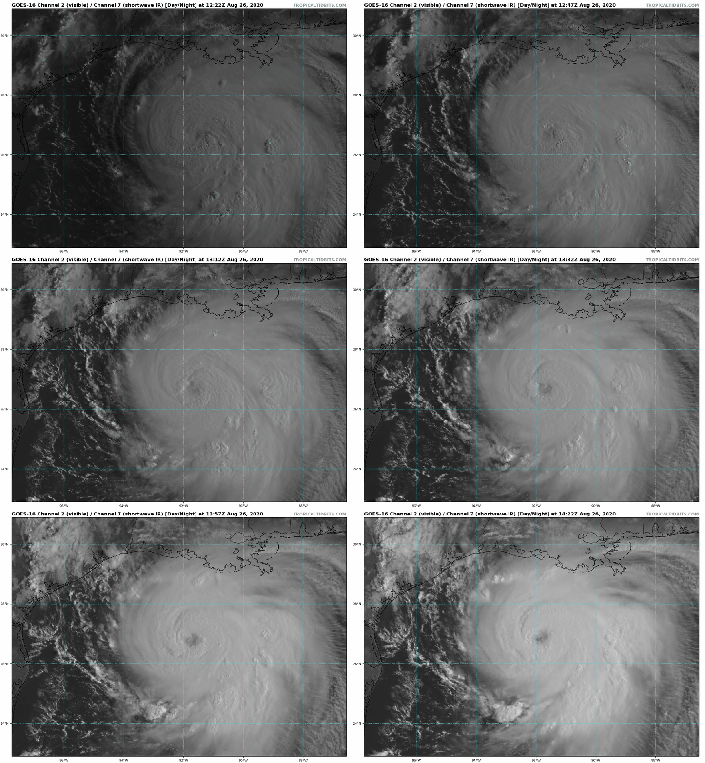
Hurricane Laura is now a Category 3 hurricane with its sights set on the Gulf Coast.

Hurricane Laura has the appearance of a classic hurricane on satellite this morning. Loop provided by Tropical Tidbits.

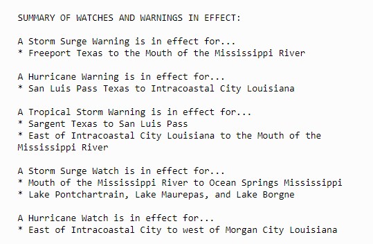
As of 11am EDT, Hurricane Laura was centered about 225 miles south-southeast of Lake Charles, Louisiana, moving toward the northwest at 16 mph. Maximum sustained winds have increased to near 125 mph, making Laura a Category 3 Hurricane. A buoy in the central Gulf of Mexico reported sustained winds of 76 mph and a gust to 107mph as the center of Laura passed nearby this morning. Hurricane and Storm Surge Warnings are in effect for portions of the Texas and Louisiana coastline, with Tropical Storm Warnings, Hurricane Watches, and Storm Surge Watches for areas adjacent to the warning areas.

Numerous watches and warnings are in effect associated with Laura. Image provided by the National Hurricane Center.

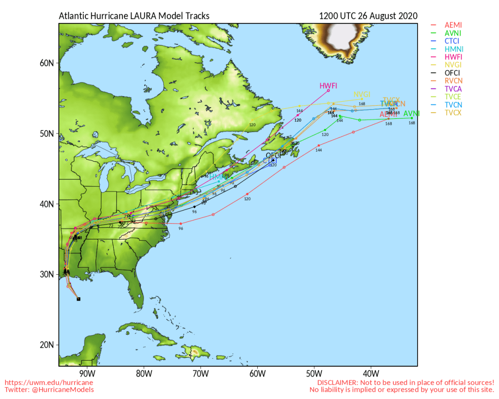
The forecast for Laura is rather simple at this point. It will continue heading northwest towards a trough of low pressure moving across the nation’s mid-section. Landfall is expected tonight very close to the Texas/Louisiana border. The only question is, how strong will Laura get? Many forecast models bring Laura up to Category 4 intensity before landfall, which would mean sustained winds of 131-155 mph. However, intensity forecasts are notoriously poor. One thing that could limit intensity would be an eyewall replacement cycle. In stronger hurricanes, you’ll get a second eyewall that forms outside the center. That eyewall will eventually start to contract towards the eye, replacing the current eyewall. When this occurs, storms tend to weaken a bit. These are very hard to predict in advance.

Model forecasts for the track of Hurricane Laura. Image provided by the University of Wisconsin.

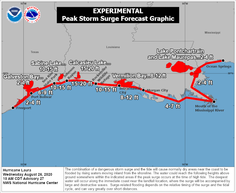
Laura presents many threats to the Gulf Coast. A storm surge of up to 15-20 feet will inundate coastal areas near and just to the east of where the center makes landfall. This will result in flooding across many of the bayous of southern Louisiana. Strong winds will obviously be a major hazard as well, mainly east of the center. The strong winds will likely penetrate well inland, as the storm will be powerful, though it should start to weaken fairly rapidly once inland.

Storm surge will be a significant threat along the Gulf Coast. Image provided by the National Hurricane Center.

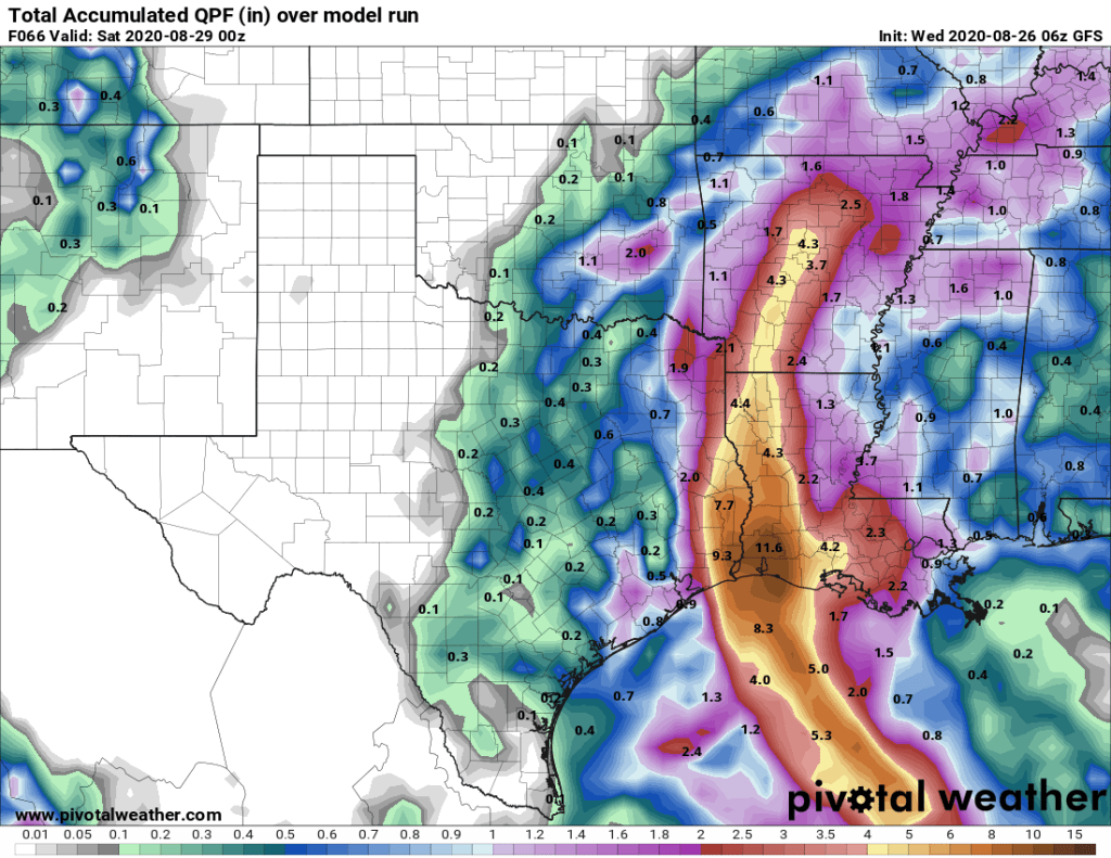
By far, the biggest threat, as it is with most tropical systems, is heavy rain and the freshwater flooding it will produce. Rainfall totals of 10-15 inches and locally heavier are likely across extreme southeast Texas and western Louisiana. Since Laura is moving fairly quickly and not expected to stall out, we shouldn’t see a repeat of the 30-60 inches that Harvey produced in the same area 3 years ago this week.

Laura will produce very heavy rainfall through Friday evening. Image provided by Pivotal Weather.

Farther inland, rainfall totals of 3-6 inches are expected up into Arkansas. As the storm gets caught up in the jet stream and becomes extratropical, it will bring heavy rain to parts of the Ohio Valley and Mid-Atlantic states Friday into Saturday. Once it moves off the coast, it may strengthen a little, and could enhance some of the rain expected across New England and Atlantic Canada this weekend associated with a cold front.

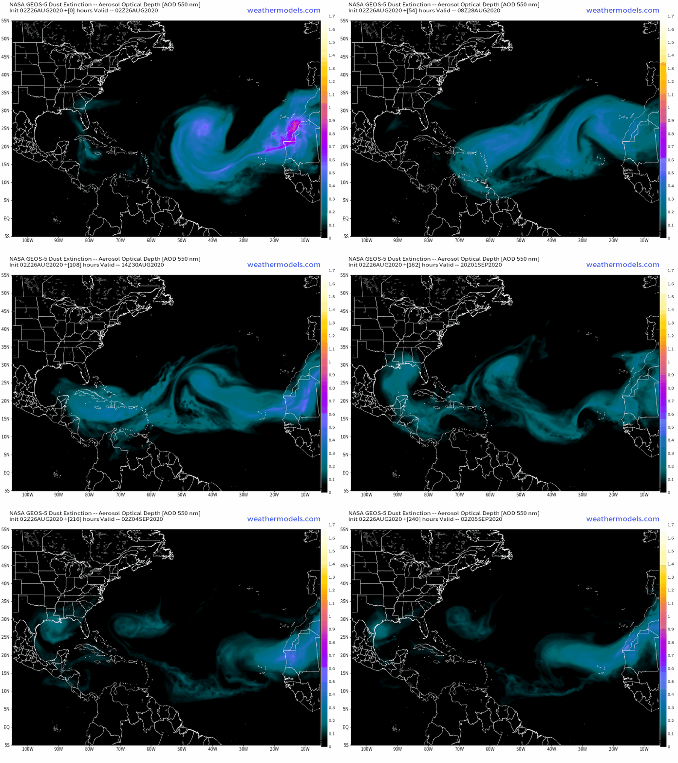
Once Laura moves inland, the Atlantic should remain quiet for the next week or so. Plumes of Saharan Dust continue to move off the west coast of Africa and traverse the Atlantic and Caribbean. The very dry air associated with these plumes inhibits thunderstorm development, which means they also prevent tropical systems from developing.

Plumes of Saharan Dust will make their way across the Atlantic over the next several days. Loop provided by Weathermodels.com

Laura isn’t the only active storm in the tropics right now. This morning two separate tropical depressions have developed in the Eastern Pacific, off the southwestern coast of Mexico. Both are expected to become tropical storms in the next 24-36 hours, but remain relatively weak. Tropical Depression 13-E may bring some heavy rain and gusty winds to southern portions of Baja California late this week, but Tropical Depression 14-E should not impact any land areas.

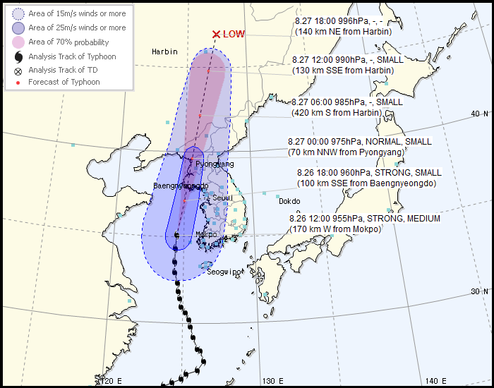
Typhoon Bavi is expected to make landfall in North Korea this evening. Image provided by the Korean Meteorological Administration.

In the Western Pacific, Typhoon Bavi has maximum sustained winds near 110 mph as it moves into the Yellow Sea. The current forecast calls for the storm to make landfall in western North Korea this evening, then rapidly weaken as it moves inland into extreme northeastern China. As with Laura, strong winds and storm surge will have significant impacts on the region, but rainfall totals of 4-8 inches and locally heavier will result in flooding in many areas.