We’ve reached the last full week of meteorological summer, but at least one day this week will likely feel more like fall.
Beneficial rain fell over the weekend, especially along and just south of the Mass Pike. Image provided by NOAA.
We start the week off with another very warm to hot and humid day today. With warm and humid conditions in place, we’ll see showers and thunderstorms develop, mainly during the afternoon hours. While not as potent as yesterday, some storms may produce heavy downpours, gusty winds, and possibly some hail. Most of the activity should diminish after sunset, but a warm and muggy night is likely.
Tuesday will be a different story. A strong cold front will be approaching the region. It will likely produce showers and thunderstorms, mainly during the afternoon and evening, and many of those storms could become strong to severe. Heavy downpours, strong winds, and hail are all threats with the stronger storms.
There is a slight risk of severe weather across most of the Northeast on Tuesday. Image provided by Pivotal Weather.
Behind that front, high pressure builds in for Wednesday with an early taste of fall for the region. High temperatures will only be in the 70s, with some spots even staying in the upper 60s. Dewpoints will also drop into the 40s and possibly the upper 30s. We could even see some low temperatures drop into the upper 40s Wednesday night. The cool air will be short-lived, as we’ll start to warm back up for Friday. While the warmer air may try to move back in on Thursday, an approaching low pressure system bring bring in clouds and showers, keeping temperatures on the cool side.
Dewpoints in the upper 30s and 40s? We haven’t seen that for a few months, Image provided by WeatherBell.
The weekend is a bit of a question mark at this point. We’ll need to keep an eye on the remains of Laura and possibly Marco. Once they move inland, they’ll rapidly weaken, but the moisture will eventually head this way. Right now it looks like we may see that rain come through late Friday into Saturday, but obviously, it’s dependent on what the storms actually do. High pressure looks to build in for Sunday with cooler and drier weather once again.
Monday: Some patchy fog early, otherwise a mix of sun and clouds with a chance for some afternoon showers and thunderstorms. High 84-91.
Monday night: Any showers end during the evening, then becoming clear to partly cloudy. Low 64-71.
Tuesday: Partly sunny and breezy with showers and thunderstorms likely during the afternoon. High 84-91.
Tuesday night: Showers and storms end in the evening then becoming mostly clear. Low 55-62.
Wednesday: Plenty of sunshine, breezy, and cooler. High 70-77.
Thursday: Intervals of clouds and sun, showers are possible late in the day and into the evening. High 71-78.
Friday: More clouds than sun with periods of rain and showers during the afternoon and at night. High 77-84.
Saturday: Plenty of clouds with some rain and showers possible. High 75-82.
This will not be a good week to take a vacation down along the Gulf Coast, especially from Louisiana into Texas, and COVID has nothing to do with it.
Tropical Storms Marco (left) and Laura (right) are both heading toward the Gulf Coast. Loop provided by Tropical Tidbits.
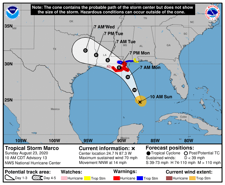
Tropical Storm Marco is the more immediate threat. As of 11am EDT Sunday, Marco was centered about 325 miles south-southeast of the mouth of the Mississippi River, moving toward the north-northwest at 14 mph. Maximum sustained winds were near 70 mph. Tropical Storm and Hurricane Watches and Warnings as well as Storm Surge Watches and Warnings are in effect for portions of the northern Gulf Coast.
Marco’s forecast is a bit complicated. The warm waters of the Gulf provide ample fuel for Marco to strengthen, and it could become a hurricane later today. However, as it heads northward, southwesterly shear will increase, which will help weaken the storm. Although hurricane warnings are in effect, Marco could weaken to a tropical storm before making landfall, likely along the Louisiana coast Monday afternoon or evening. Since there is little difference between a strong tropical storm and a weak hurricane, this has little impact on what will actually occur across the region.
Forecast track for Tropical Storm Marco. Image provided by the National Hurricane Center.
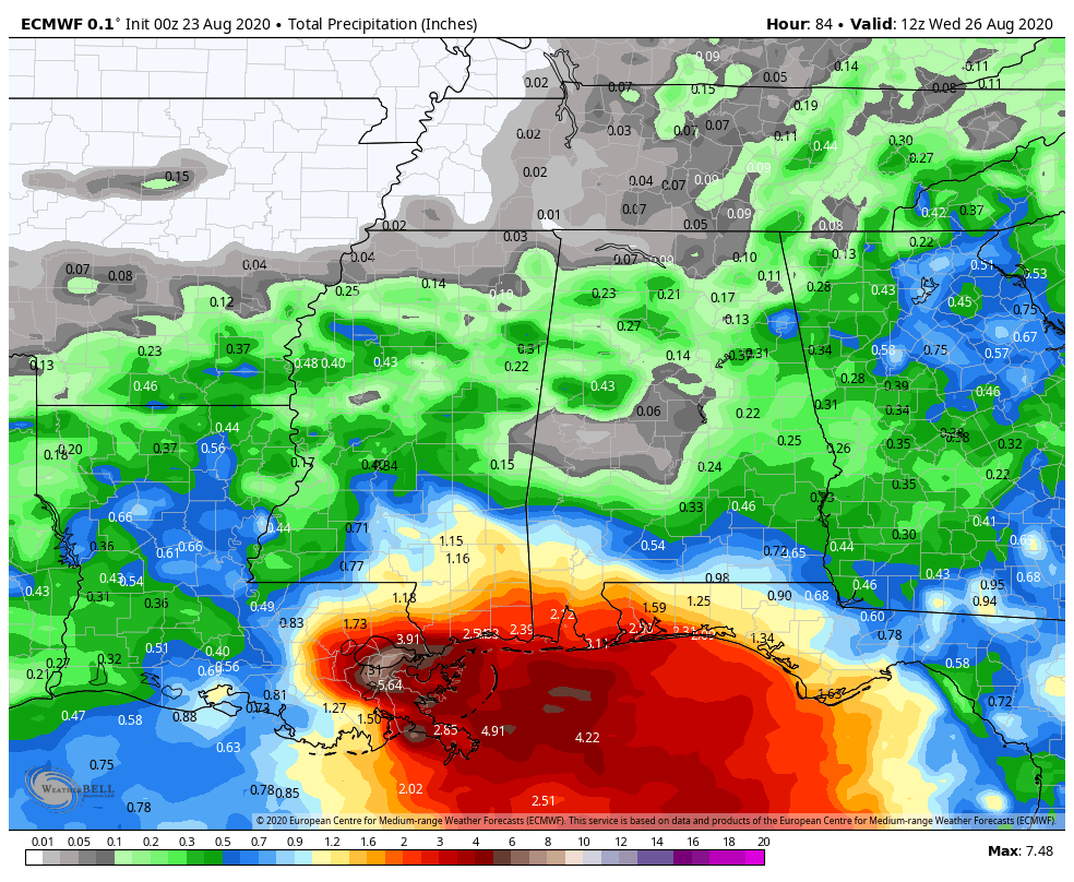
Marco will produce strong winds, mainly along the coast, and a storm surge of up to 6 feet will result in flooding along the coast and in the low-lying bayous of southern Louisiana. However, Marco’s biggest threat will be flooding from heavy rainfall. Rainfall totals of 3-6 inches and locally heavier will result in flooding in many areas. This is exacerbated in New Orleans, where much of the city itself is below sea-level and even heavy thunderstorms can produce flooding. We’re not expecting Katrina-level flooding, and the levees shouldn’t be tested too much by this storm, but widespread flooding is likely.
ECMWF model forecast for rainfall through Wednesday morning. Image provided by WeatherBell.
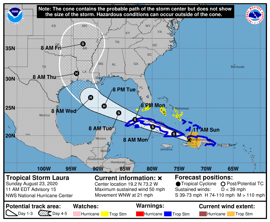
Marco is the initial threat, but Tropical Storm Laura is the more significant threat to the Gulf Coast. As of 11am EDT Sunday, Laura was centered about 95 miles southeast of the eastern tip of Cuba, moving toward the west-northwest at 21 mph. Maximum sustained winds were near 50 mph. Tropical Storm Warnings are in effect for parts of the Dominican Republic, Haiti, Cuba and the Southeastern Bahamas, with Tropical Storm Watches in effect for the Central Bahamas and the Florida Keys.
In the near-term, Laura is expected to traverse the entire length of Cuba for the next day or so, producing heavy rain and gusty winds. Heavy rains will diminish across the Dominican Republic and Haiti today as Laura pulls away. With the center interacting with land, little strengthening is anticipated for the next 24-36 hours, and some weakening is possible. Once we get to late Monday, things become a bit more complicated.
Forecast track for Tropical Storm Laura. Image provided by the National Hurricane Center.
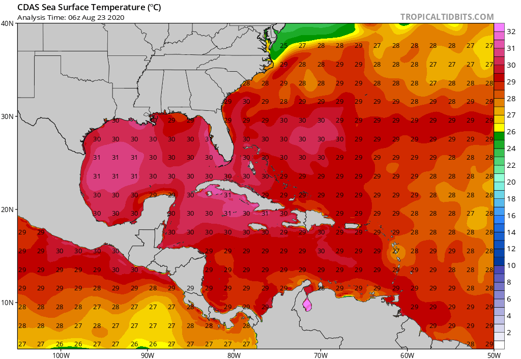
Laura is expected to move into the southeastern Gulf of Mexico Monday evening as a tropical storm. Once it does, it will find an environment that is favorable for strengthening. Water temperatures are well into the 80s, providing plenty of fuel for the system. (Tropical systems need water warmer than 80F/26C to survive and/or strengthen) A ridge of high pressure will also be building in aloft, resulting in very little wind shear. This is also an area that climatologically favors rapid intensification of tropical systems. Several models show the potential for Laura to quickly become a hurricane and possibly a major hurricane as it moves across the Gulf of Mexico on Tuesday. It should be noted that intensity forecasts for tropical systems, especially from forecast models, have been known to be rather poor.
The track forecast for Laura is also a bit uncertain. The ridge of high pressure building in will help steer Laura more towards the west-northwest. How strong that ridge actually is will help determine how far west Laura moves. While the models were nearly unanimous just 24 hours ago that Laura was heading towards the Central Gulf Coast, they have shifted westward, putting parts of Texas and western Louisiana in the crosshairs. Additional shifts are likely over the next day or two as the models adjust to what is actually going on in the atmosphere. For now, residents of the Gulf Coast from Central Texas to Alabama should keep a close eye on Laura’s progress.
There are no other systems in the Atlantic that are being monitored right now, but we are approaching the peak of Hurricane Season, so that will likely change soon. There are two systems in the Eastern Pacific that may become tropical depressions in the next day or two, and Typhoon Bavi will be a threat to Korea over the next 24-48 hours in the Western Pacific.
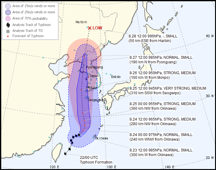
Forecast track for Typhoon Bavi. Image provided by the Korean Meteorological Admininstration.
As of 11am EDT, Typhoon Bavi was centered about 600 miles south-southwest of the southwestern South Korea, moving toward the northeast at 9 mph. Maximum sustained winds were near 80 mph. Bavi is expected to turn more toward the north over the next 12-24 hours, with some additional strengthening expected. The current forecast calls for Bavi to move into the Yellow Sea, and pass just west of South Korea, before making landfall in extreme northwestern North Korea, then it will move into extreme northeastern China where it will rapidly weaken. Strong winds and storm surge flooding are likely across the Korean Peninsula over the next few days, with heavy rain likely causing flooding along the Peninsula as well as in northeastern China. Parts of this region have received heavy rain recently, and some flooding has already occurred, so this will exacerbate it in some areas.
The hype machine is getting cranked up again because we have two tropical systems in or near the Caribbean at the moment.
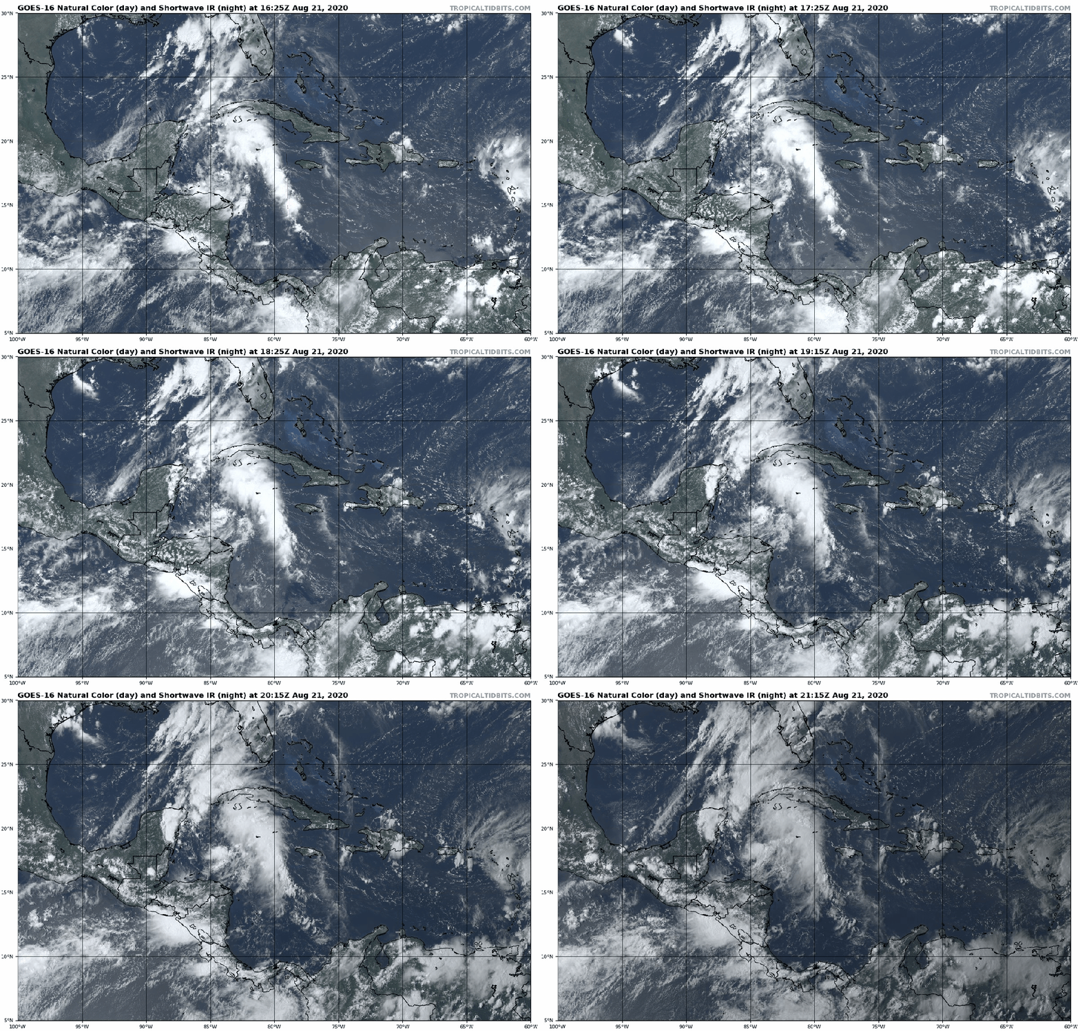
Tropical Depression 14 is located in the Western Caribbean while Tropical Storm Laura is moving into the Leeward Islands. Loop provided by Tropical Tidbits.
The media is already in a frenzy because some forecast models show both systems becoming hurricanes and moving into the Gulf of Mexico early next week. While this is certainly a possibility, it is far from a lock. As is usually the case, we’ll separate fact from fiction for you.
We’ll start with Tropical Storm Laura, as it is the “stronger” of the two systems at the moment, though you wouldn’t know it from looking at satellite pictures. As of 5pm EDT, Laura was centered about 40 miles east of Antigua with maximum sustained winds near 40 mph, and was moving toward the west at 17 mph. Tropical Storm Warnings are in effect for much of the northeastern Caribbean and Hispaniola, with a Tropical Storm Watch in effect for the southeastern Bahamas and the Turks and Caicos Islands. Laura does not have much thunderstorm activity associated with it, and the 40 mph estimate for winds may be very generous. Antigua has not reported winds higher than 10 mph all day long, though winds have gusted as high as 25 mph on Sint-Maarten.
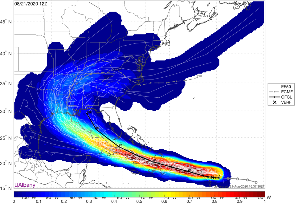
Track forecasts for Tropical Storm Laura based on the ECMWF Ensemble. Image provided by the University at Albany.
The forecast for Laura is both simple and complicated at the same time. With a large ridge of high pressure over the Atlantic, Laura will continue west-northwestward for the next few days. That’s the simple part. Exactly where the center tracks has huge implications on its intensity. A track near or over Puerto Rico and then near or over Hispaniola and/or Cuba will mean the system remains very weak, if it even survives. However, if the center stays over water, especially if it remains far enough away from land, then it may have a chance to strengthen. The official forecast from the National Hurricane Center calls for it to become a hurricane late Monday or early Tuesday while moving into the southeastern Gulf of Mexico. While this is certainly possible, we’ve got a long way to go before determining how likely this scenario is.
In the short term, we can expect some heavy rain and gusty winds across the northeastern Caribbean and into Puerto Rico and Hispaniola over the next couple of days. Rainfall totals of 3-6 inches and locally heavier will lead to flooding and mudslides.
Heavy rain will produce flooding and mudslides from Puerto Rico into Hispaniola this weekend. Image provided by WeatherBell.
Meanwhile, in the western Caribbean we have Tropical Depression 14. As of 5pm, it was centered about 255 miles southeast of Cozumel, Mexico with maximum sustained winds near 35 mph, and was moving toward the northwest at 13 mph. A Tropical Storm Warning and Hurricane Watch are in effect for the Yucatan Peninsula of Mexico from Punta Herrero to Cancun. The Tropical Storm Warning actually extends along the north coast of the Yucatan to Dzilam.
The depression appeared to have 2 low-level centers this morning based on reconnaissance information, but they have now consolidated into one center. Despite that, the system has been slow to strengthen, despite seemingly favorable conditions with warm waters and low wind shear. The forecast from the National Hurricane Center calls for some strengthening before the storm makes landfall in the northeastern Yucatan Saturday night. Assuming it becomes a Tropical Storm, it will be named Marco.
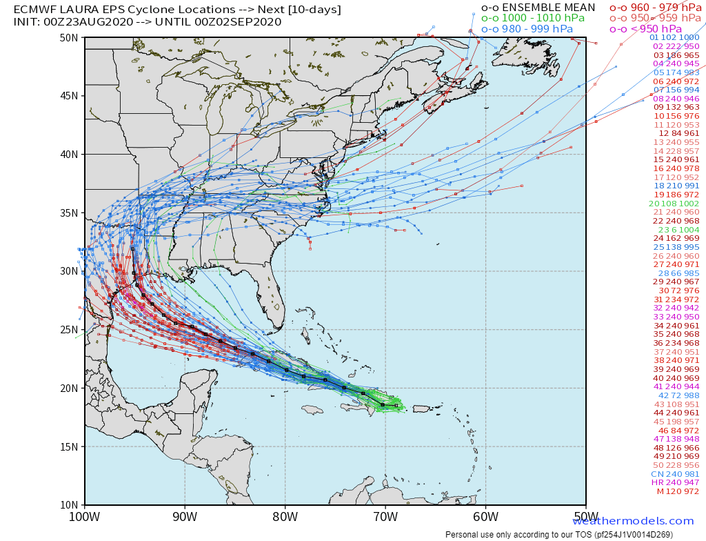
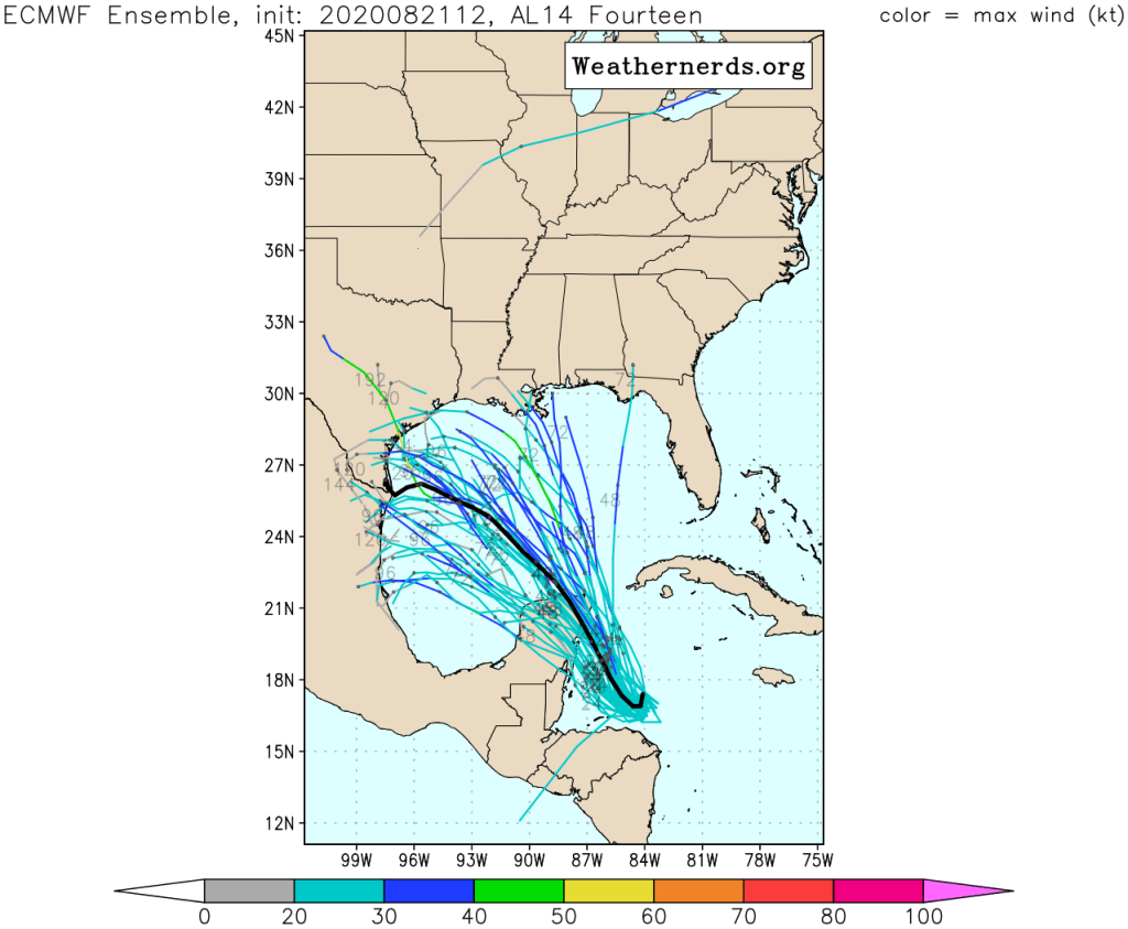
ECMWF Ensemble forecasts for the track of Tropical Depression 14. Image provided by Weathernerds.org
Once it emerges into the Gulf of Mexico, the questions increase. Will it continue northwestward or bend more toward the west-northwest? This will be determined by how strong the ridge over the Atlantic is. Some models show it building westward into the Gulf, which would send TD 14 (and also TS Laura) on a more west-northwestward track. How strong will TD 14 get? There’s plenty of warm water over the Gulf, but wind shear is forecast to increase, which will limit the strengthening of the system.
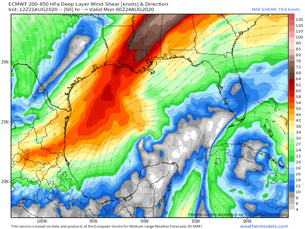
The ECMWF model shows up to 50 knots of southwesterly shear in the western Gulf of Mexico Sunday night. That is not conducive for a strengthening tropical system. Image provided by Weathermodels.com
So, despite the media hype of “2 hurricanes in the Gulf at the same time” for early next week, the odds seem to be just as good that we may not have any hurricanes in the Gulf. There could be 2 tropical storms, or maybe 1 hurricane, or maybe only 1 storm. At this point, it is just to early to make that call. The other ridiculous statement we’ve heard is that the storms could collide. This just doesn’t happen. If two storms get close to each other, we get what is called the Fujiwhara Effect. Essentially, they start to rotate around each other. Alternately, if they get close to each other and one is considerably stronger than the other, the circulation around it could create enough wind shear to essentially destroy the weaker of the two storms.
Finally, another tropical wave is approaching the Cabo Verde Islands. It has some potential for development, and will be watched as it crosses the Atlantic over the next several days.
We need some rain, and there’s some in the forecast, but we need a lot more.
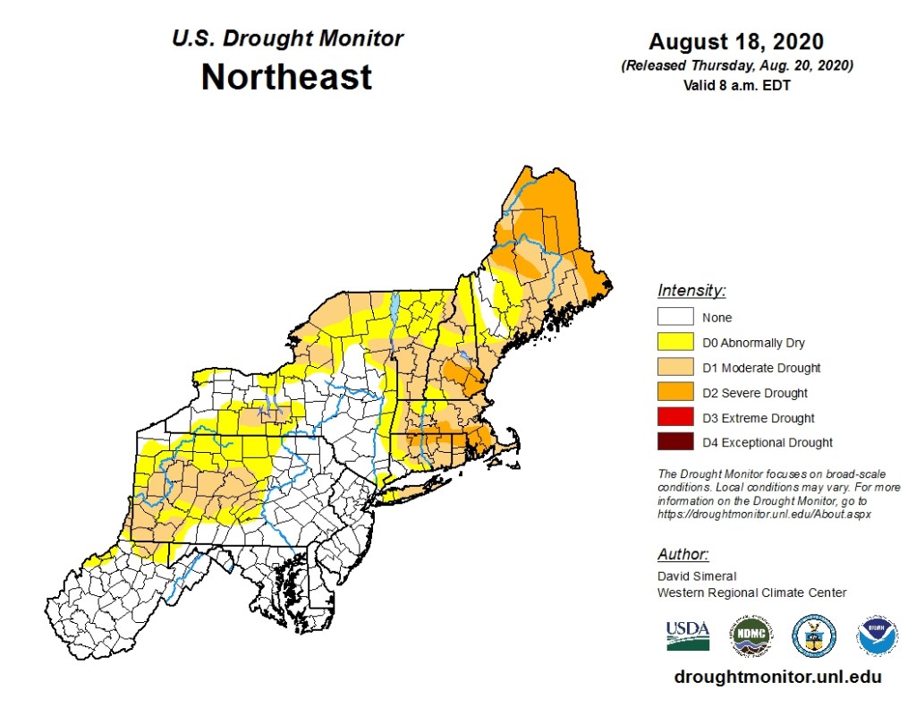
We’ve had a little rain, but we need a lot more, as the drought is getting worse. Image provided by the National Drought Mitigation Center.
With high pressure sliding offshore, a warming trend is expected for Friday into Saturday, along with an increase in humidity levels. We’ll remain sunny on Friday, but may see a few more clouds on Saturday. A shower or thunderstorm may pop up here or there on Saturday, but they’ll be few and far between.
By Sunday, things start to change. An upper-level disturbance will head toward the region, bringing us more clouds, along with some showers and thunderstorms. A few of them may produce gusty winds and downpours, but this does not look like a widespread severe outbreak. It also doesn’t look like the widespread rain that we need, but every little bit helps. A cold front then moves through on Monday, with more showers and thunderstorms possible.
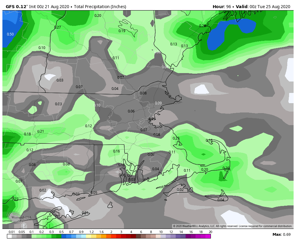
We’re not expecting a lot of rain between now and Monday evening. Image provided by WeatherBell.
Thursday night: Clear skies. Low 55-62.
Friday: Sunshine and a few afternoon clouds. High 83-90.
Friday night: Clear to partly cloudy. Low 61-68.
Saturday: A mix of sun and clouds, slight chance for an afternoon shower or thunderstorm. High 81-88.
Saturday night: Partly cloudy. Low 61-68.
Sunday: Partly sunny, showers and thunderstorms possible in the afternoon. High 83-90.
Sunday night: Partly cloudy. Low 65-72.
Monday: A mix of sun and clouds, afternoon showers and thunderstorms possible. High 83-90.
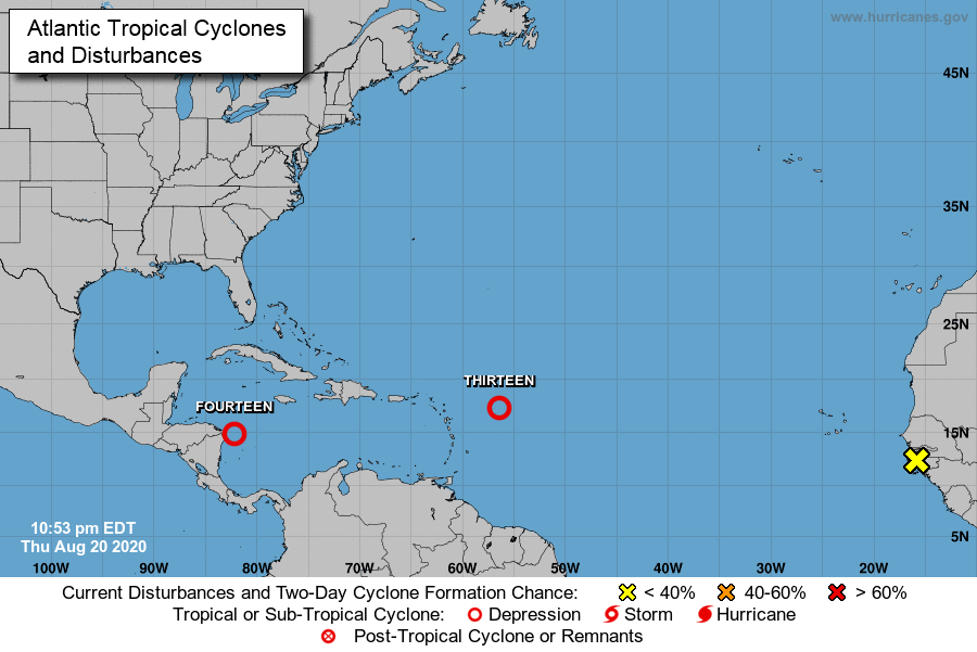
There are two tropical depressions in the Atlantic at the moment. Image provided by the National Hurricane Center.
In the tropics, Tropical Depression 14 is moving into the western Caribbean and Tropical Depression 13 is approaching the Leeward Islands. The former will be a threat to parts of Central America and the Yucatan Peninsula this weekend, and the latter to the Leeward Islands as well as Puerto Rico and the Virgin Islands. We’ll have a much more detailed blog post about the tropics Friday afternoon or evening.
As has been the case for a few months now, most of the upcoming week will be dry across the region, but not all of it.
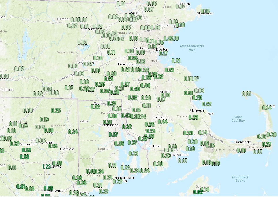
Up to half an inch of rain had fallen across the region through midnight, but much more is needed. Image provided by NOAA.
We did receive some beneficial rainfall across parts of Southern New England on Sunday, and it may linger into this morning, especially across parts of the Cape, before low pressure finally pulls away from the region. However, an upper-level disturbance will move through later today, and it may kick off a few additional showers or even a thunderstorm. This won’t be a widespread beneficial rain, but every little bit helps to alleviate the drought.
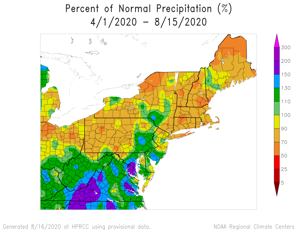
Dating back to the beginning of April, rainfall is well below normal across the region. Image provided by the Northeast Regional Climate Center.
High pressure builds in on Tuesday, and remains in place through Friday, with generally dry and seasonably warm conditions expected. Humidity levels will remain comfortable as well, with dewpoints generally in the 50s.
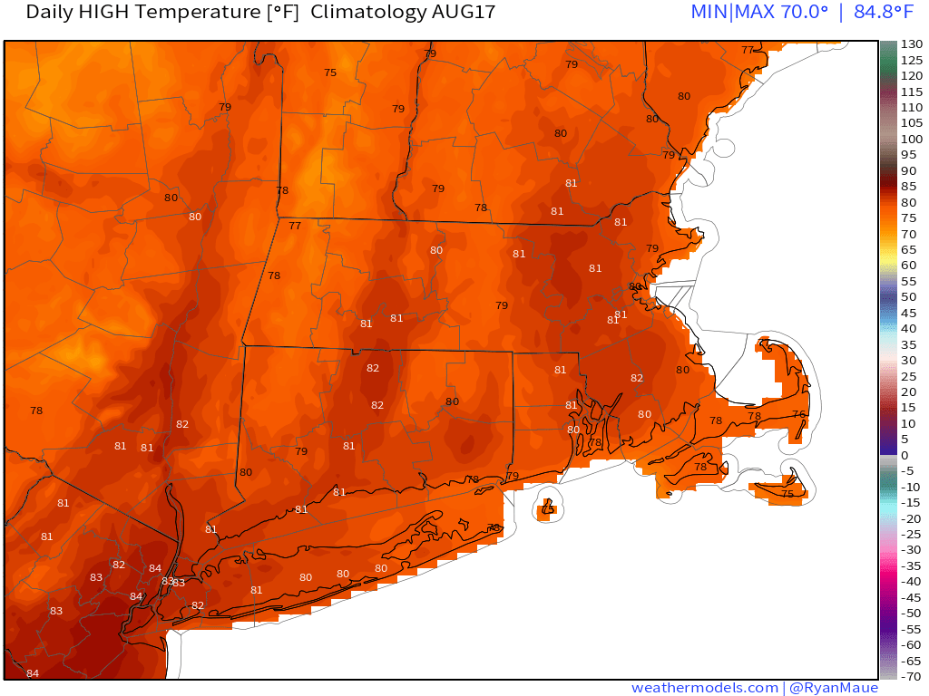
Average high temperatures in mid-August are in the upper 70s to lower 80s. Image provided by Weathernodels.com.
Clouds start to move back in on Saturday and humidity levels start to rise as a cold front approaches from the west. This front will likely produce some showers and thunderstorms later Saturday into Sunday, but the timing will depend on how quickly the front actually crosses the region. We’ll nail down those details in our Weekend Outlook on Thursday.
Monday: Early clouds and a few showers, then becoming partly sunny with a chance for a few late-day showers. High 73-80, coolest along the coast.
Monday night: Mostly cloudy with some more showers possible, mainly during the evening. Low 59-66.
Tuesday: Becoming partly to mostly sunny. High 77-84.
Tuesday night: Clear to partly cloudy. Low 56-63.
Wednesday: Sunshine and some afternoon clouds. High 76-83.
Thursday: Plenty of sunshine. High 77-84.
Friday: Mostly sunny. High 79-86.
Saturday: Partly sunny, chance for some afternoon and evening showers and thunderstorms. High 82-89.
Sunday: A mix of sun and clouds, chance for some showers and thunderstorms. High 78-85.
We’ve got a tug-of-war this weekend between high pressure to our northeast and a frontal boundary stalled out to the south. For the most part, the high should win out.
The late-morning surface analysis shows high pressure buolding into northern new England and a frontal stalled near the South Coast. Image provided by the Weather Predicition Center.
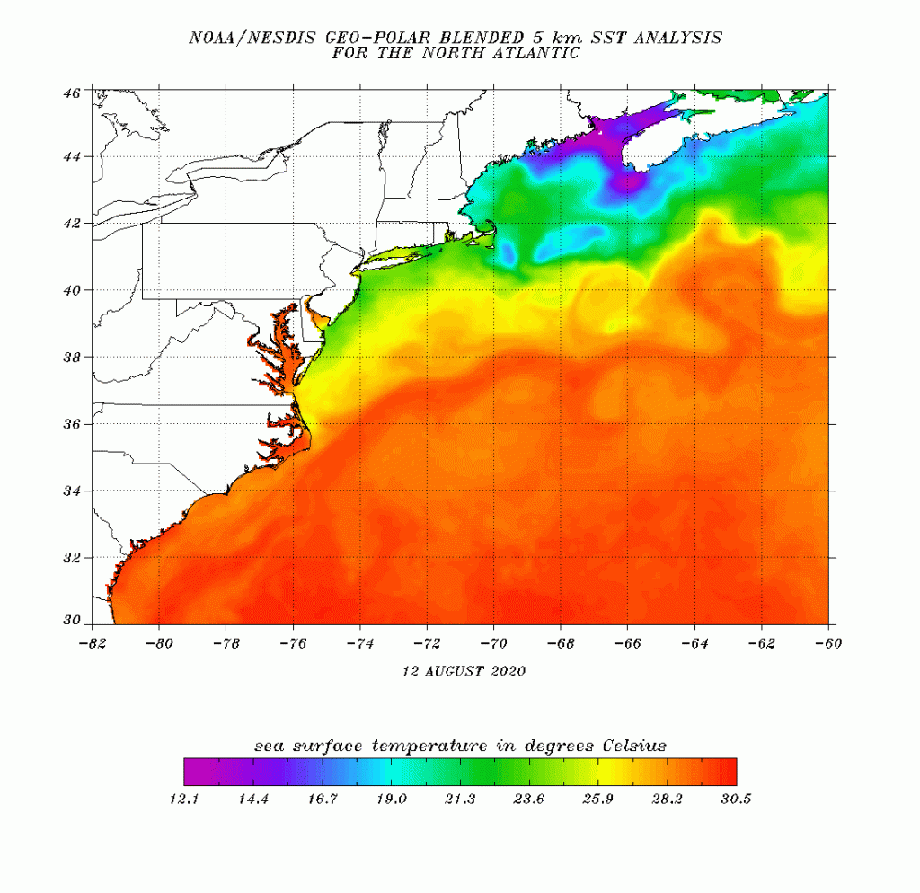
As high pressure builds in, drier air has also settled in, with dewpoints dropping into the 50s across much of the region. While we’ll still be warm today, cooler air will gradually settle in over the next few days, thanks mainly to east to northeast winds off of the Atlantic. The ocean is about the warmest it will get around here during the year, but it’s still only in the 60s and lower 70s east of New England, so winds blowing off the water will still have a cooling effect, especially along the coastline.
Current sea-surface temperature analysis. Image provided by NOAA.
Meanwhile, that front to the south will keep some clouds around, especially along the South Coast. A couple of waves of low pressure will ride along this front. They’ll bring heavy rain and thunderstorms to the Mid-Atlantic states, where flash flood watches and warnings remain in effect, but around here, they won’t do much for now. The first wave should pass harmlessly south of the region, except for possibly a few showers along the south coast this afternoon and evening. It’s the second wave, for late Sunday and Monday, that we’re keeping an eye on. Many of the models have it coming in farther north, bringing us some showers and thunderstorms late Sunday into Monday. However, we’ve also had plenty of times recently when the models have been trying to bring in widespread showers a few days out, and they just haven’t materialized. As we’ve said several times, the old forecaster’s adage is “When in Drought, Leave it Out”. We wouldn’t be surprised if the high pressure area wins out again, and most of us stay dry Sunday night and Monday too.
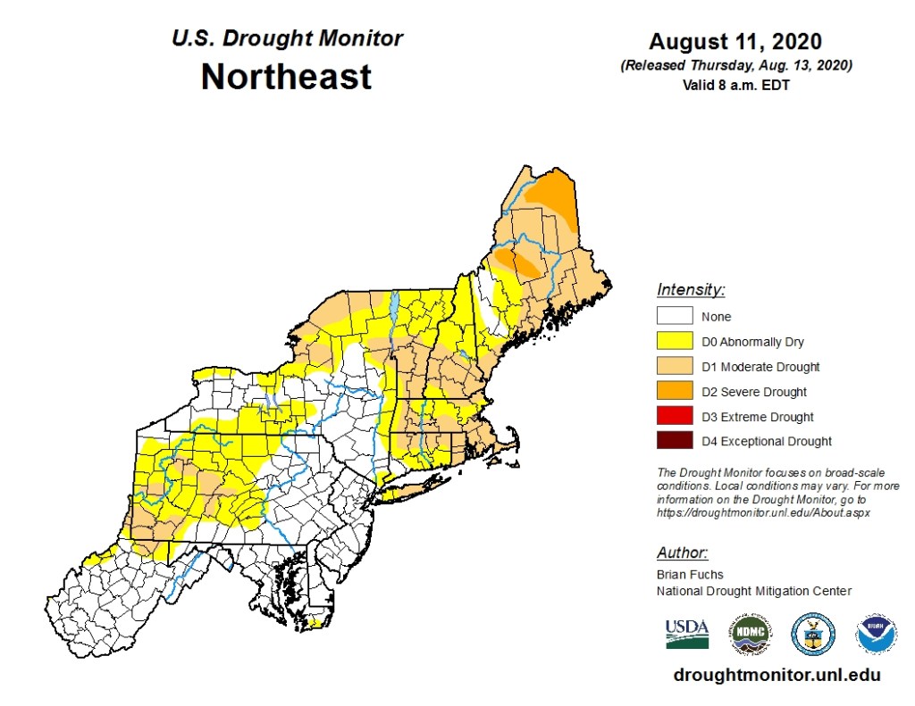
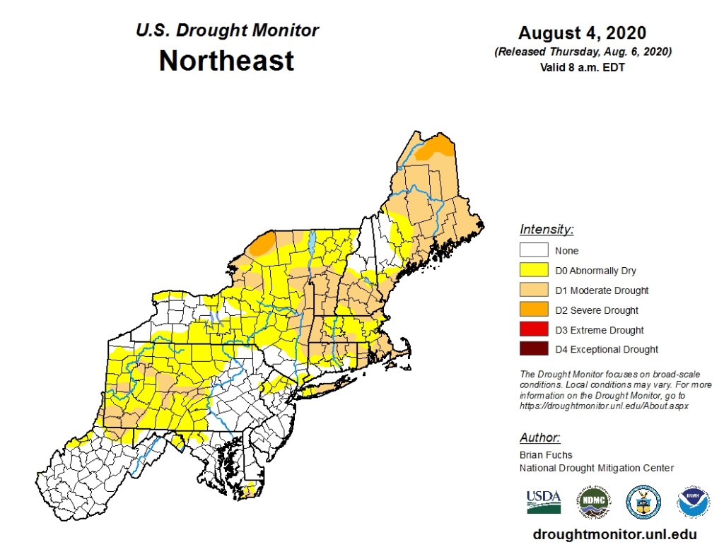
The latest Drought Monitor shows the drought worsening across the Northeast. Image provided by the National Drought Mitigation Center.
Thursday night: Clear to partly cloudy. Low 63-70.
Friday: Partly to mostly sunny. High 79-86, coolest along the coast.
Friday night: Clear to partly cloudy. Low 60-67.
Saturday: A mix of sun and clouds, breezy. High 73-80, coolest along the coast.
Saturday night: Partly to mostly cloudy. Low 58-65.
Sunday: Mostly cloudy with a chance for a few showers. High 72-79.
Sunday night: Mostly cloudy, chance for some showers. Low 61-68.
Monday: Plenty of clouds with some sunny breaks, some showers are also possible. High 75-82.
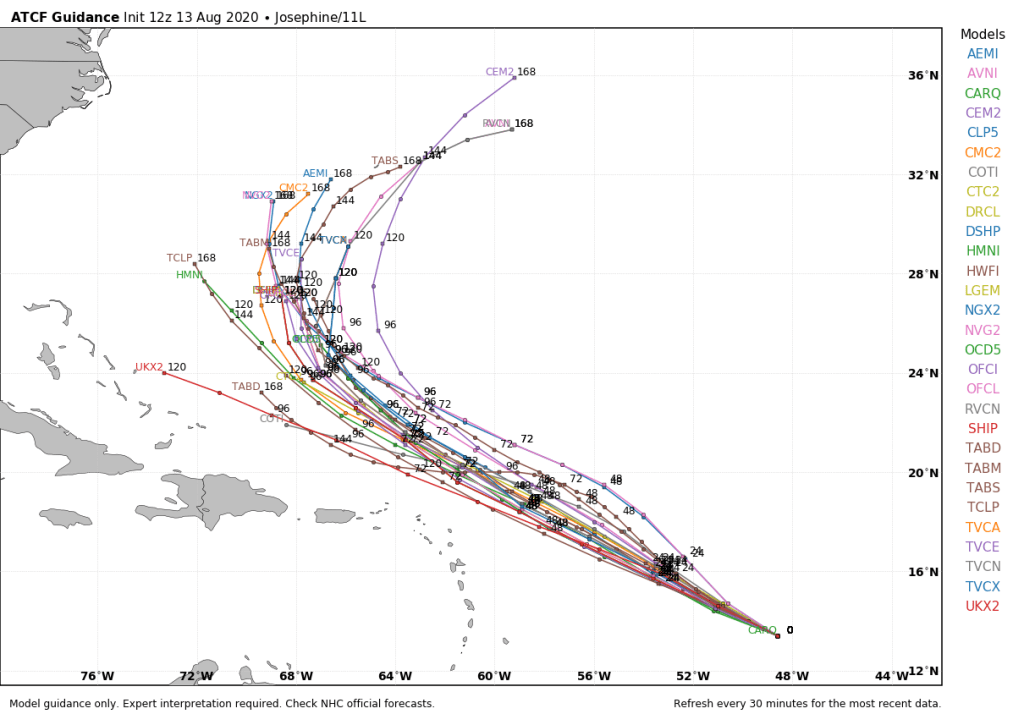
Forecast tracks for Tropical Storm Josephine. Image provided by WeatherBell.
Finally, we’ll briefly mention Tropical Storm Josephine. Tropical Depression 11 strengthened into Tropical Storm Josephine this morning. As of midday, it was centered a little less than 1000 miles east of the Lesser Antilles, moving toward the west-northwest at 15 mph. Maximum sustained winds are near 45 mph. Josephine may strengthen a little more in the next day or so, but after that, it will be moving into some rather unfavorable conditions. The current forecast calls for it to pass north of the Antilles this weekend, by which point strong wind shear could rip the system apart. It will likely dissipate without threatening any land areas. Even if it does survive, it will start to recurve and head out to sea north of the Greater Antilles and east of the Bahamas.
The heat and humidity are back, and they’ll hang around for at least a few days.
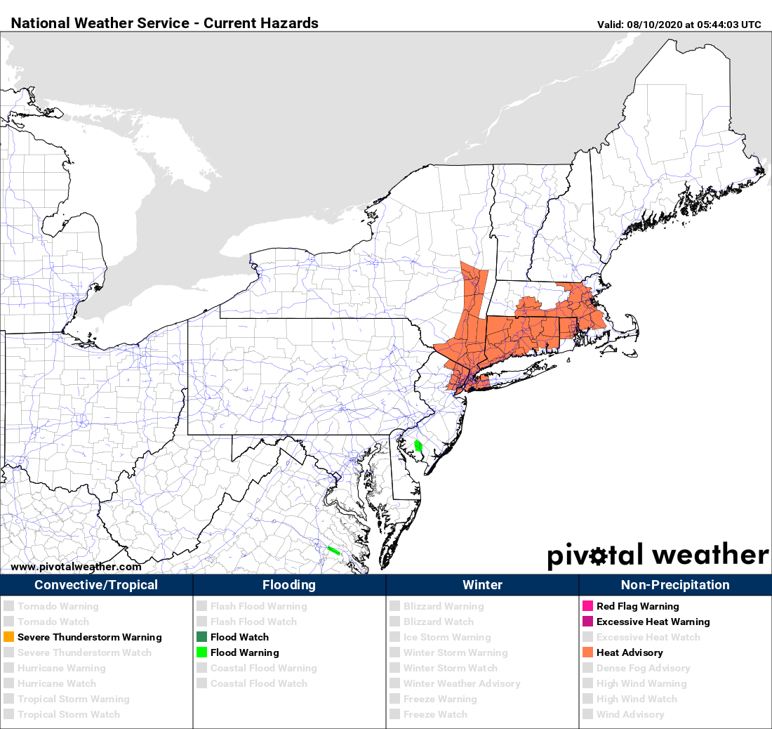
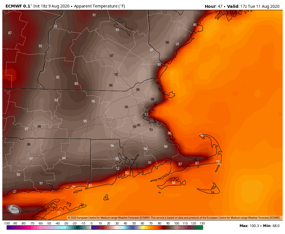
We start the week with high pressure in control, pumping warm to hot and humid weather in for Monday and Tuesday. Many places away from the shoreline will top 90, and when the humidity is factored in, it will feel like its in the middle to upper 90s, especially on Tuesday. Heat advisories have been posted for this afternoon and Tuesday for much of interior Southern New England. A couple of pop-up showers and thunderstorms may develop this afternoon, but they’ll be few and far between, and even less likely on Tuesday.
Wednesday will be another hot and humid day, but a cold front will be slowly approaching from the west. It will produce some more numerous showers and thunderstorms during the afternoon. Some of these storms may produce heavy downpours and gusty winds, but for now at least, it doesn’t look like we’ll have widespread severe weather. More showers and thunderstorms are likely on Thursday before the front finally gets through the region. The front looks like it will stall out just to the south, which will keep clouds and possibly more showers around for Friday, especially south of the Mass Pike. High pressure finally builds in for next weekend with drier and cooler conditions.
Showers and storms will bring in some much-needed rain late this week, but a lot more is needed to help alleviate the drought. Image provided by Weathermodels.com
Monday: Some patchy fog this morning, otherwise a mix of sun and clouds, just a few widely scattered showers and thunderstorms this afternoon, humid. High 85-92, coolest along the coast.
Monday night: Clear to partly cloudy, some patchy fog may redevelop. Low 66-73.
Tuesday: Mostly sunny, hot, and humid, a very slight chance for a shower or thunderstorm. High 89-96.
Tuesday night: Clear to partly cloudy and muggy. Low 67-74.
Wednesday: Partly sunny, humid, showers and thunderstorms likely during the afternoon and evening. High 88-95.
Thursday: More clouds than sun with scattered showers and thunderstorms. High 82-89.
Friday: More showers south of the Mass Pike, mainly during the morning, otherwise, skies gradually clear out from north to south. High 80-87, cooler along the coast.
Saturday: Partly to mostly sunny. High 76-83, coolest along the coast.
It won’t be all sunshine and warm temperatures, but we should be able to salvage a decent weekend around here.
The high pressure system providing us with a nice day today will slide off to the east tonight, while a weak low pressure system moves along a frontal boundary that has stalled out to our south. That will send clouds our way tonight and Friday. Some showers and maybe even a thunderstorm are expected on Friday as the front tries to lift northward, but they’ll likely be confined to areas south of the Mass Pike. With plenty of cloud cover and east to northeast winds, it definitely be cooler than it has been for a while.
Temperatures may stay in the 70s all day Friday across much of the region. Image provided by WeatherBell.
As we get to Saturday, a weak upper-level disturbance will move across the region. We’ll still have plenty of clouds, especially early, with a few showers or thunderstorms possible as the disturbance moves through. However, once it exits, skies should start to clear out late in the day, and we’ll get a bit warmer. High pressure returns for Sunday and Monday, with warm and humid conditions returning to the area.
The drought will continue to get worse until we get some significant rain on a regular basis. Image provided by the National Drought Mitigation Center.
Tropical Storm Isaias is near the Carolina coastline this afternoon, but struggling to maintain its intensity.
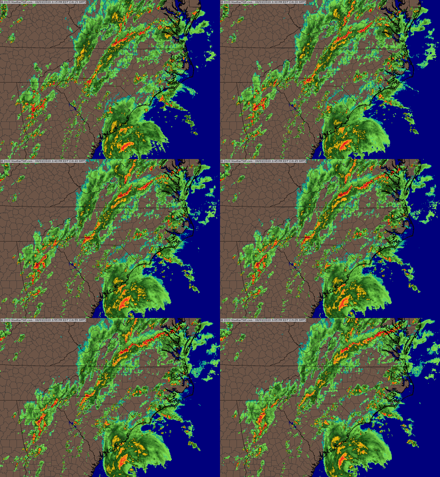
The center of Isaias now shows up on radar off the South Carolina coast. Loop provided by Weathertap
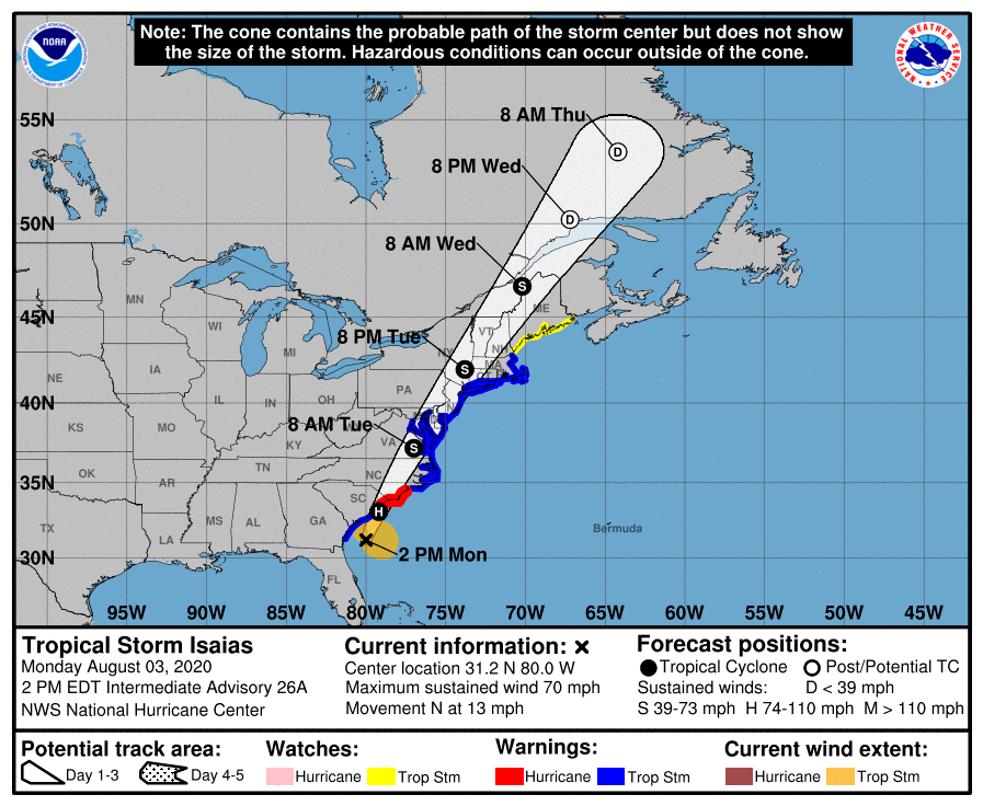
As of 2pm Monday, Tropical Storm Isaias was centered about 115 miles south of Charleston, South Carolina, moving toward the north at 13 mph, though radar and data from Air Force reconnaissance aircraft appear to show a motion more toward the north-northeast. The National Hurricane Center says maximum sustained winds are near 70 mph, but again, data from reconnaissance aircraft show the system to be weaker than that.
Forecast track for Tropical Storm Isaias. Image provided by the National Hurricane Center.
A Hurricane Warning is in effect from South Santee River, South Carolina to Surf City, North Carolina. A Storm Surge Warning is in effect from Edisto Beach, South Carolina to Cape Fear, North Carolina, and also from Oregon Inlet, North Carolina to the Virginia/North Carolina border, including Pamlico and Albemarle Sounds. Between Cape Fear and Oregon Inlet, a Storm Surge Watch is in effect. A Tropical Storm Warning is in effect south of South Santee River to Altamaha Sound, Georgia, and north of Surf City, all the way to the Mouth of the Merrimack River in Massachusetts, , including Chespeake Bay, the Tidal Potomac, River, Delaware Bay, and Long Island Sound. North of the Merrimack River, a Tropical Storm Watch is in effect to Eastport, Maine.
Isaias should continue heading north-northeastward, making landfall near the South Carolina/North Carolina border this evening. Although the official forecast calls for the storm to strengthen back into a hurricane before landfall, this appears unlikely at this point. There really isn’t much difference between a strong tropical storm and a weak hurricane anyway, so it’s a moot point. Once inland, it should continue on a north-northeast track, moving up the coastline, steered by an upper-level trough moving in from the west. Normally, tropical storms weaken rapidly as they move over land and away from warm water, which is their main source of energy. However, Isaias will be making the transition into an extratropical storm, so it may not weaken that rapidly.
There are a few differences between tropical and extratropical storms.Image provided by the University of Rhode Island Graduate School of Oceanography
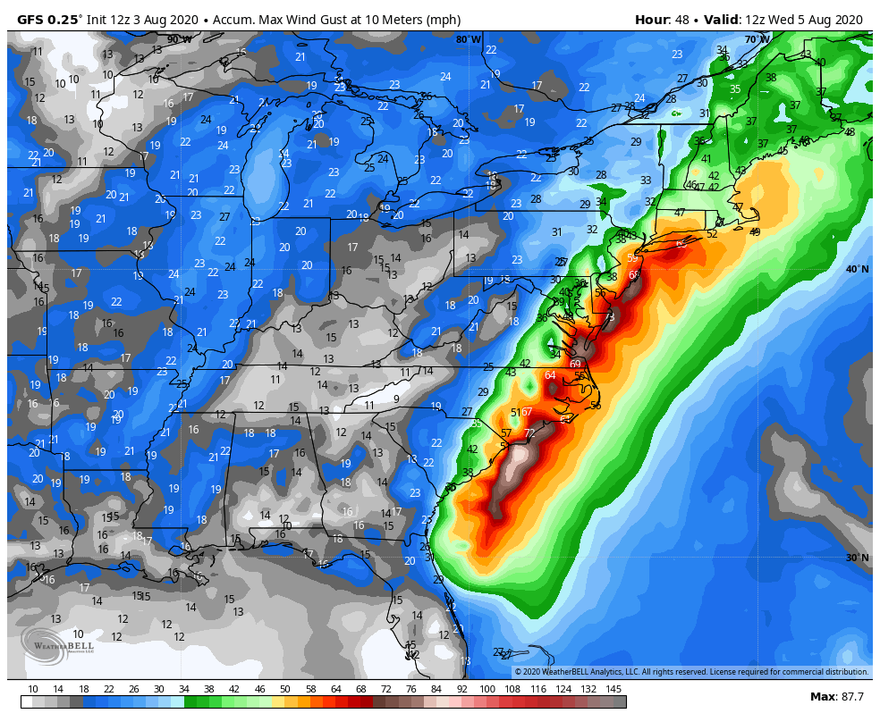
Storm surge will be a threat along the Carolina coast, near and east of where the center makes landfall. A surge of up to 5 feet above normal tide levels could result in some coastal flooding. Strong winds will also be a threat, mainly east of the storm’s center. Wind gusts of 40-50 mph have been reported just off the South Carolina coastline this afternoon. As it moves northward, some strong winds will be likely across eastern North Carolina as the storm moves inland, and possibly across eastern New England late Tuesday as the system moves across the Northeast.
The strongest winds will be east of the storm’s track and mainly offshore. Image provided by WeatherBell.
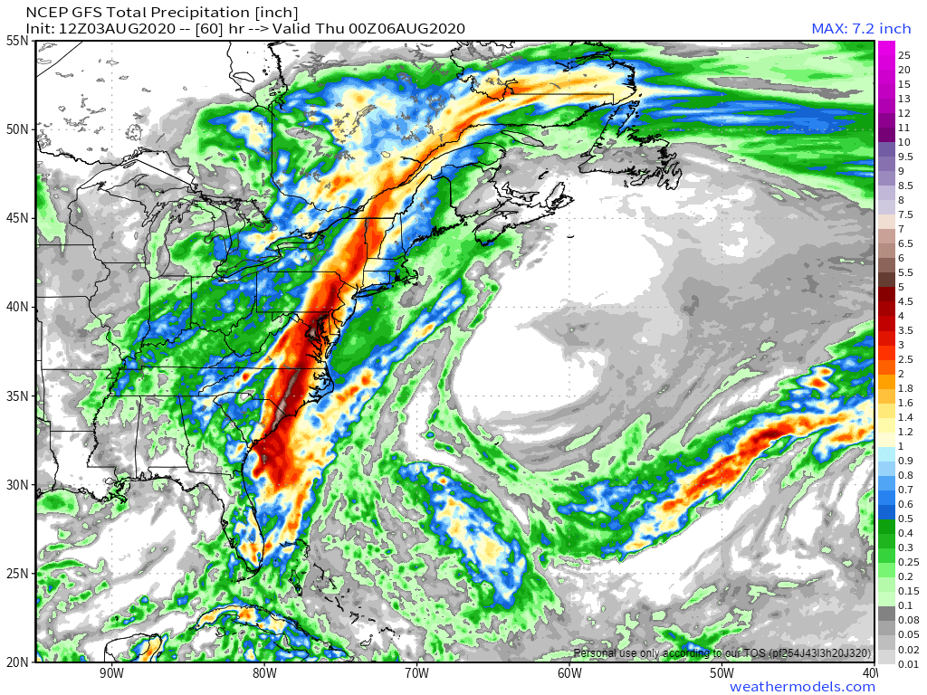
By far, the biggest threat with Isaias is heavy rainfall and the resulting flooding. The heaviest rain is likely along and west of the storm’s track. Rainfall totals of 3-6 inches and locally heavier are likely from the Carolinas into eastern Canada, which will produce flooding in many areas. The storm’s relatively quick motion will preclude even heavier totals. East of the storm’s track, rainfall will be much lighter, with many places likely seeing less than 1 inch, which won’t help with the drought developing across eastern New England.
Isaias will produce heavy rainfall along and west of its track from the Carolinas into eastern Canada. Image provided by Weathermodels.com
Elsewhere, we’re keeping an eye on a tropical wave located a few hundred miles south of Bermuda. Conditions could become favorable for it to develop into a tropical depression in a few days. Model forecasts show it heading northwestward for the next few days, staying over open water. By mid-week, most forecasts show it stalling out about midway between Bermuda and the Bahamas. It does not look like a threat to any land areas at this time.
The forecast for the upcoming week is both complex and simple at the same time.
Barring a surprise, Isaias will almost certainly track to our west. Image provide by Tropical Tidbits.
We start the week off with a hot and humid day today, thanks to high pressure located over the Atlantic (more on that in a bit). Temperatures will get into the upper 80s and 90s across the region this afternoon. When you combine that with dewpoints generally in the 60s, it’ll feel like it’s in the mid 90s during the afternoon. Clouds will quickly start to stream in at night, making for a rather warm and muggy evening.
The heaviest rain from Isaias will stay well to our west. Image provided by Weathermodels.com
As we head into Tuesday, we turn our eyes to the southwest and Tropical Storm Isaias. The combination of a trough of low pressure approaching from the west and that high pressure over the Atlantic will steer Isaias into the Carolinas late tonight or early Tuesday. After that, it will start to quickly move north-northeastward, likely passing west of the region late Tuesday night or early Wednesday. Most of the heavy rain will be located west of the track, but we’ll still have some showers and tropical downpours around here late Tuesday and Tuesday night. The storm should also be weakening and passing far enough to our west to spare us from any significant wind issues. It’ll be breezy, with some gusts to 40 mph or so possible, especially along the South Coast, but overall, it really shouldn’t be too big of a deal. Once again, the hype will be likely worse than the reality.
The potential exists for wind gusts to 50 mph, but they’ll likely be lower. Image provided by WeatherBell.
By Wednesday morning, Isaias is out of here and skies will clear out, with drier air settling in as high pressure builds into the region. That high should remain in place for the rest of the week and into the weekend, with seasonably warm temperatures and comfortable humidity levels.
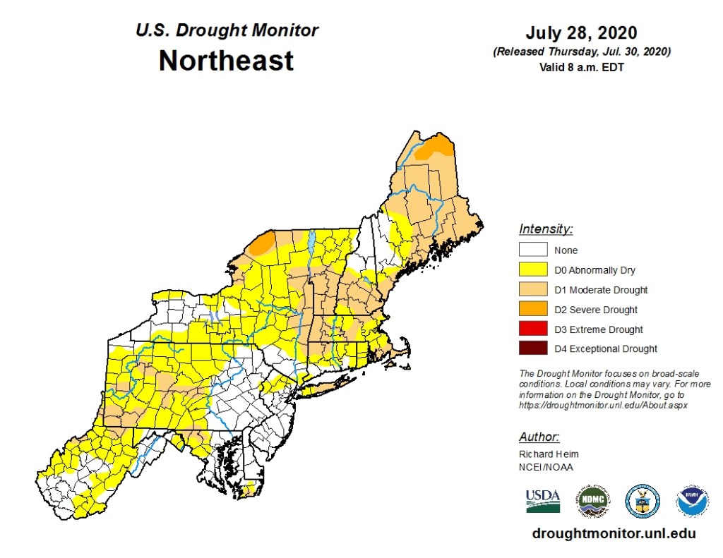
Dry weather for the latter half of the week will not help with the developing drought. Image provided by the National Drought Mitigation Center.
Monday: Partly to mostly sunny, breezy, and hot. High 86-93.
Monday night: Becoming mostly cloudy with a few showers possible. Low 67-74.
Tuesday: Cloudy and becoming windy with showers likely, some of them may be briefly heavy. High 79-86.
Tuesday night: Mostly cloudy and windy with showers ending, skies may start to clear late at night. Low 67-74.
Wednesday: Becoming partly to mostly sunny. High 81-88.









 Storm HQ