In math and science, Delta is used to reference change. Using that definition, Hurricane Delta has been aptly named, as it has been changing by the minute.
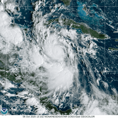
Tropical Depression 26 developed late Sunday night south of Jamaica. Just 36 hours later, the system has become Hurricane Delta, a Category 4 storm with maximum sustained winds near 140 mph. While rapid intensification was always a possibility since the storm was sitting in the northwestern Caribbean over some of the warmest waters of the entire Atlantic Basin, nobody expected it to become this powerful this quickly, and it may not be done yet.
As of 2pm EDT Tuesday, Delta was centered about 260 miles east-southeast of Cozumel, Mexico, moving toward the west-northwest at 16 mph. Hurricane Warnings are in effect for parts of the Yucatan, including the resort locations of Cancun and Cozumel. Tropical Storm Warnings are also in effect for parts of the Yucatan and western Cuba.
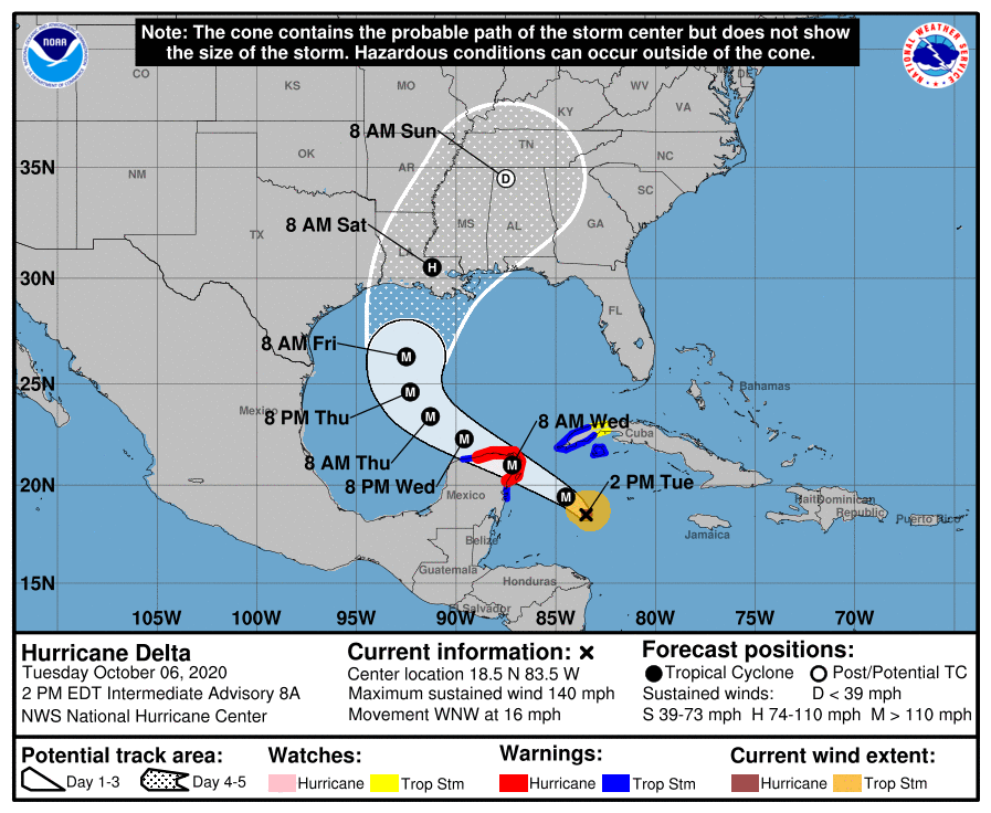
Delta is expected to move across the northeastern Yucatan on Wednesday as a Category 4 storm, passing close to or over Cozumel and Cancun. Likely impacts include a storm surge of 6-12 feet, wind gusts in excess of 100mph, and rainfall totals of 3-6 inches and locally heavier will produce flooding and mudslides. The only saving grace is that Delta should be moving along fairly quickly, so that will limit the amount of time that hurricane conditions are expected.

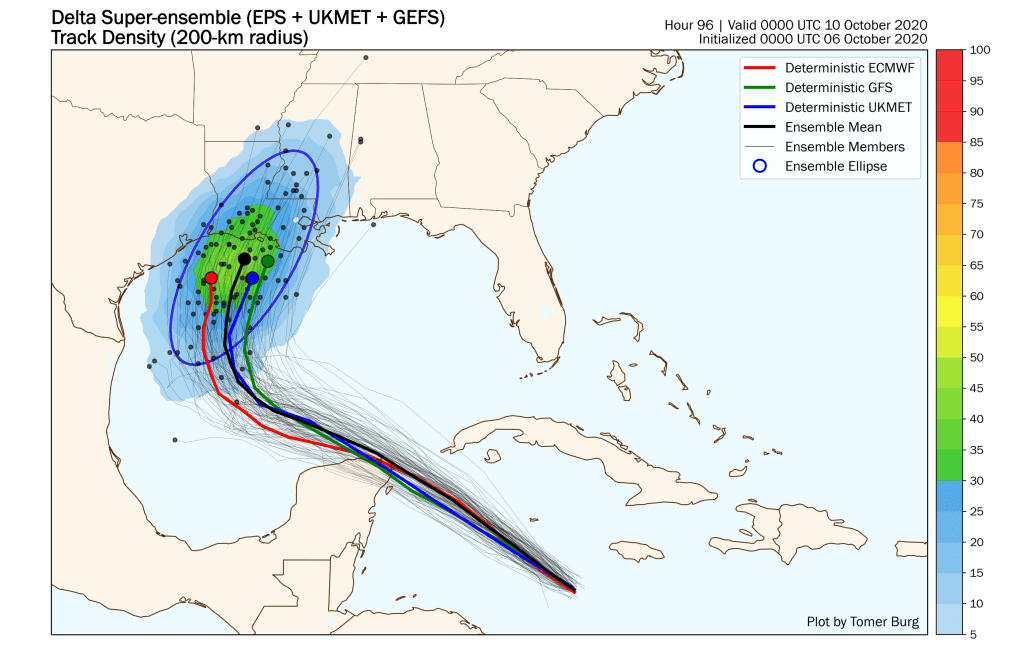
Once Delta emerges in the southern Gulf of Mexico, it should eventually start to turn more toward the northwest and then north. When that turn occurs will be important for determining where landfall will happen. Most of the models are currently clustered in central or western Louisiana, with a timeframe of late Friday night or early Saturday. This is the same area that was battered by Hurricane Laura several weeks ago. However, this can, and probably will change a little over the next few days.
As far as intensity, Delta should weaken a little as it moves over the Yucatan on Wednesday, but then strengthen again as it moves back over the Gulf of Mexico. The recent trend has been for storms to continue to intensify up until landfall in the Gulf, but that does not look like it will be the case with Delta. For one, some wind shear will start to impact the system as it moves across the central and northern Gulf, but water temperatures closer to the Gulf Coast has dropped recently thanks to a series of cold front moving into the region. Delta should still be a formidable storm, but it likely won’t be a Category 4 at landfall along the Gulf Coast.

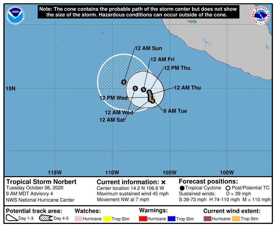
Meanwhile, in the Pacific Ocean, Tropical Storm Marie continues to wind down and should dissipate over open water in the next 12-24 hours. However, Tropical Storm Norbert has formed off the southwestern coast of Mexico. Norbert is centered about 365 miles south-southwest of Manzanillo, Mexico, and has maximum sustained winds near 45 mph. Norbert is expected to meander around over open water, with some strengthening possible in the next few days.
Much farther to the west, Tropical Storm Chan-Hom could become a threat to parts of southwestern and southern Japan late this week. Chan-Hom currently has maximum sustained winds near 65 mph, but strengthening is likely, and it could become a typhoon in the next day or two. A northwestward track towards the Ryukyu Islands will continue for the next day or two, before the system starts to recurve towards the north and eventually northeast. When that recurve takes place will determine what, if any, impacts, the system has on southern Japan. Right now, it looks like heavy rain will be the biggest threat, but obviously, wind could become a factor, depending on the actual track.

