Back to Reality in a Hurry

Hope you enjoyed the record warmth today, because Mother Nature is going to quickly remind you that it is still February.

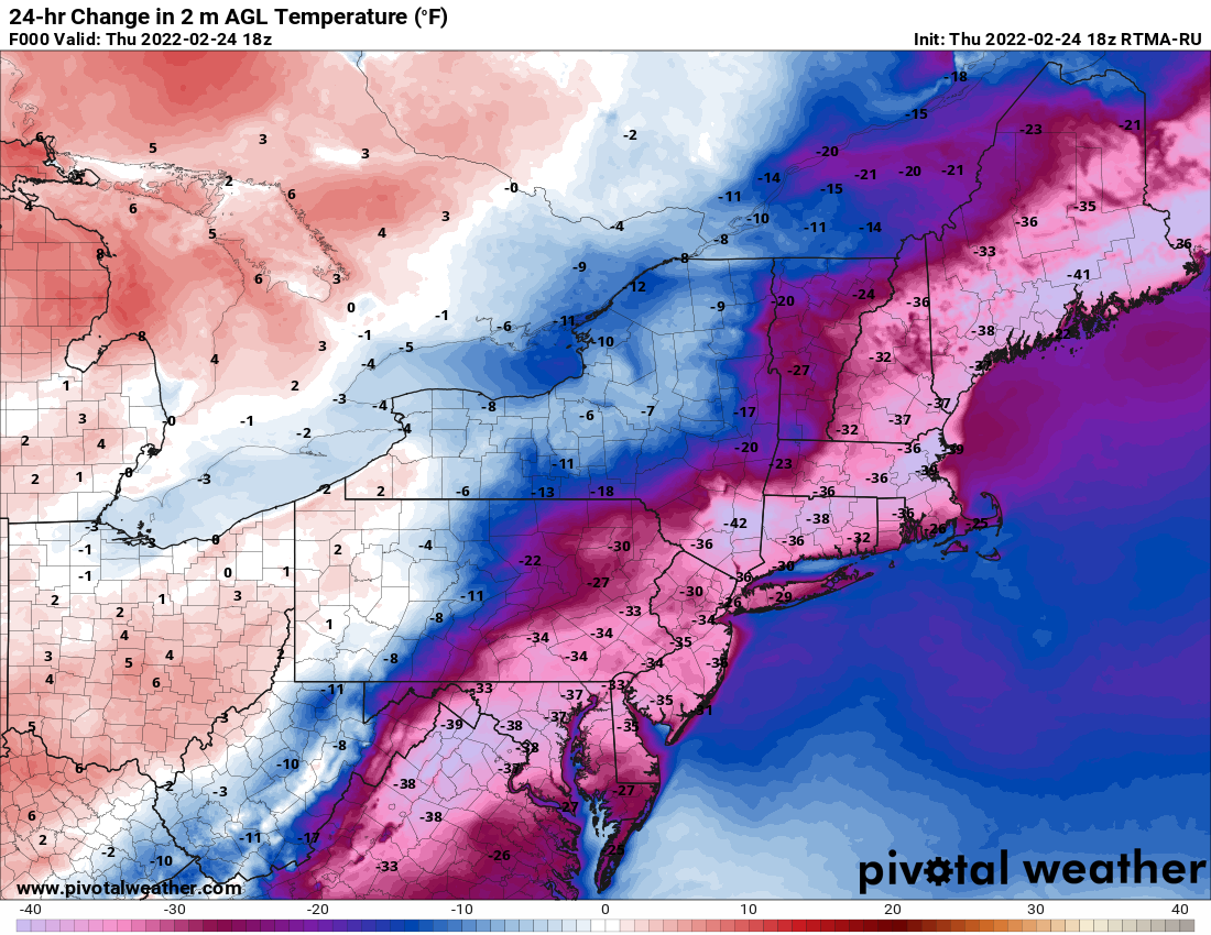
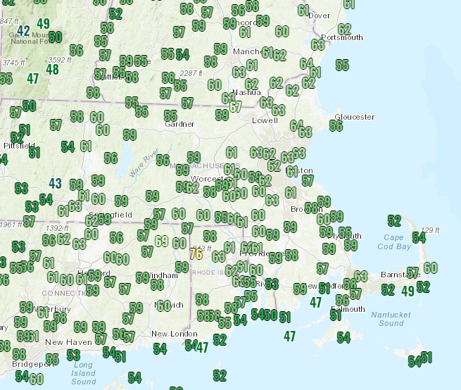
Temperatures got well into the 50s and lower 60s across the region Saturday afternoon. Image provided by Weathermodels.com

Unseasonably mild temperatures continued across the region on Saturday, with a few records set, but a cold front moved through around midday, and a stronger one will move through this evening, bringing an abrupt end to the mild weather. Temperatures will quickly drop tonight as the front pushes offshore, and on Sunday, most places will likely be in the 30s or even upper 20s during the daytime. That’s not the big story though.

A wave of low pressure will ride along the front on Sunday, passing south and east of the region. It will be close enough to produce some light snow and snow showers across parts of eastern Massachusetts and Rhode Island, possibly even into southern New Hampshire, during Sunday morning and early afternoon. Most of the snow will remain light, with accumulations of an inch or two possible, mainly from Boston southward. The story doesn’t end there. As the low passes by, winds will shift into the northeast, which will result in some ocean-effect snow across parts of Cape Cod and coastal Plymouth County, and possibly Cape Ann as well. The areas that receive snow will be highly dependent on the wind direction. Northeast winds will spread the snow inland across southeastern Massachusetts, but as winds shift into the north Sunday night, the bands of ocean-effect snow will retreat closer to the coast of Plymouth County and across Cape Cod. By Monday morning, winds will shift into the northwest, bringing an end to the snow for most of us.

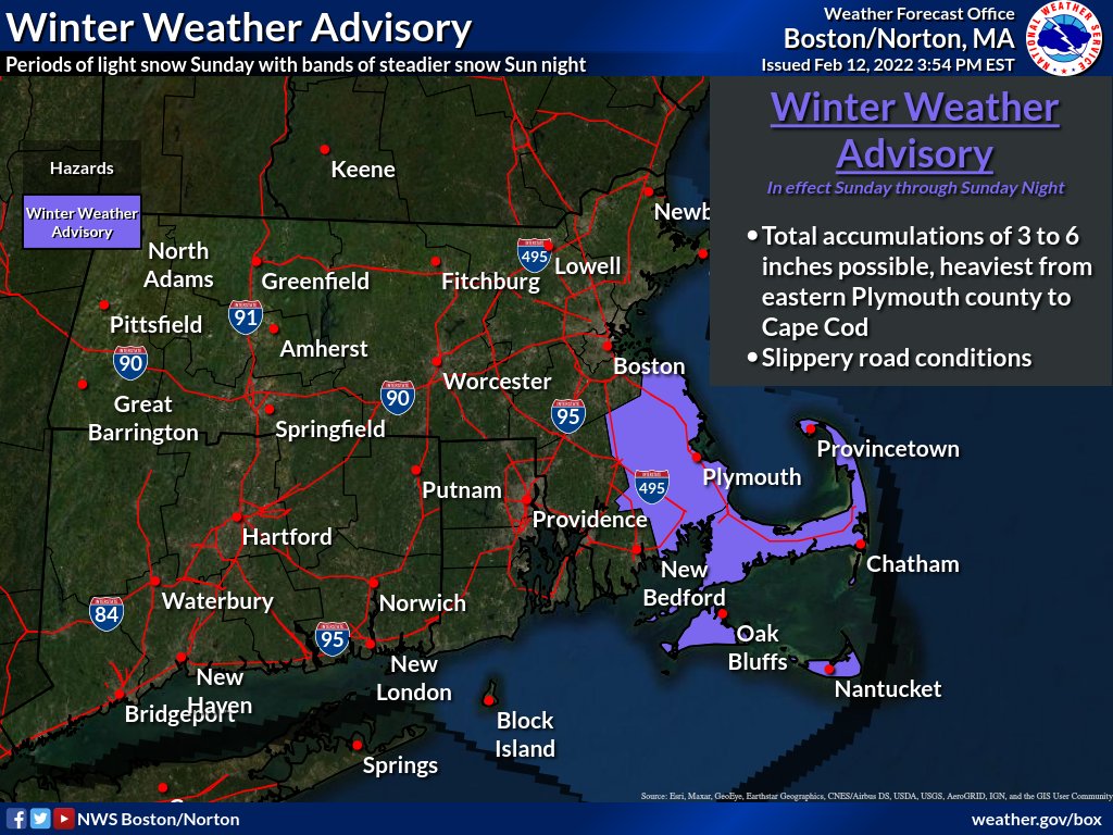
A Winter Weather Advisory is in effect for Cape Cod and the Islands as well as Plymouth County. Image provided by the National Weather Service office in Norton, MA.

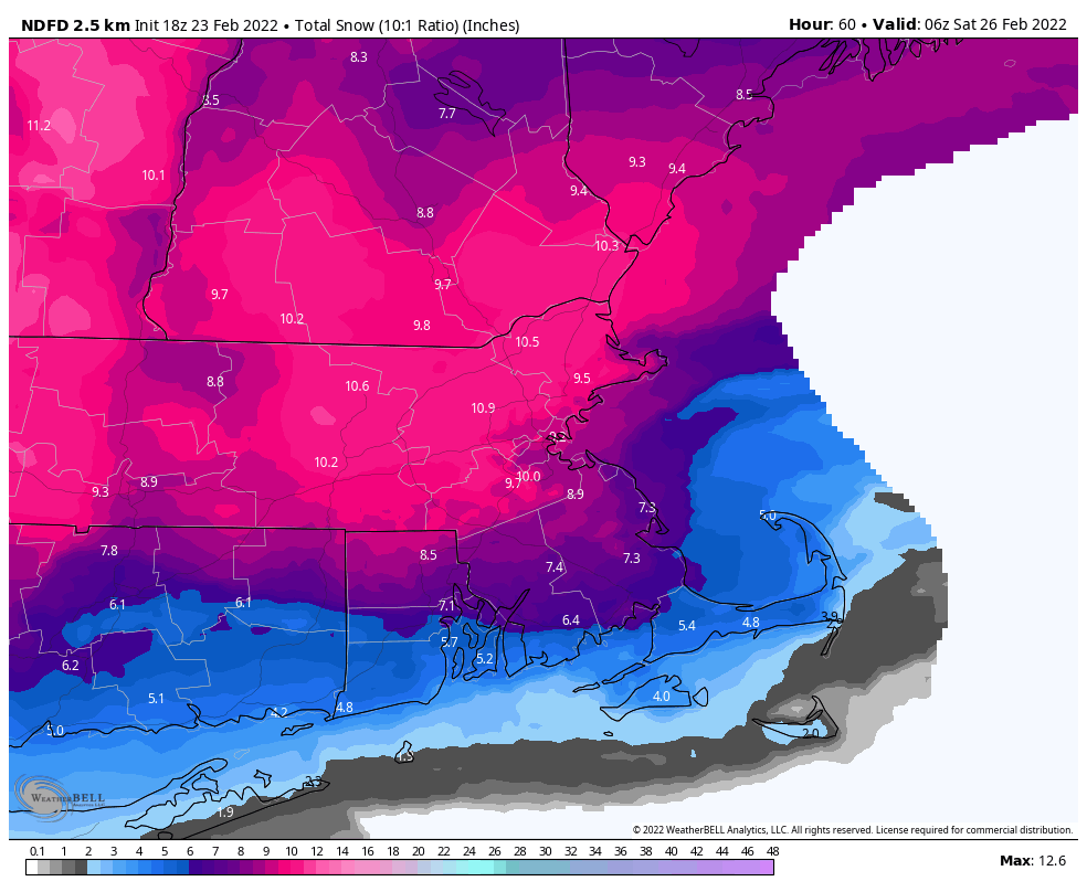
How much snow may fall? North and West of I-495, just a dusting to perhaps a half an inch. From 495 to I-95, some spots could see an inch, possibly 2 inches. It’s areas south of Boston (and Cape Ann), that may need shovels (and possibly plows). Across interior portions of southeastern Massachusetts as well as Cape Ann, we could see 2-4 inches of snow. The “jackpot” is likely to be across coastal Plymouth County as well as parts of Cape Cod, where as much as 4-7 inches could accumulate.

The heavy snow is likely from coastal Plymouth County into Cape Cod Sunday into early Monday. Image provided by WeatherBell.

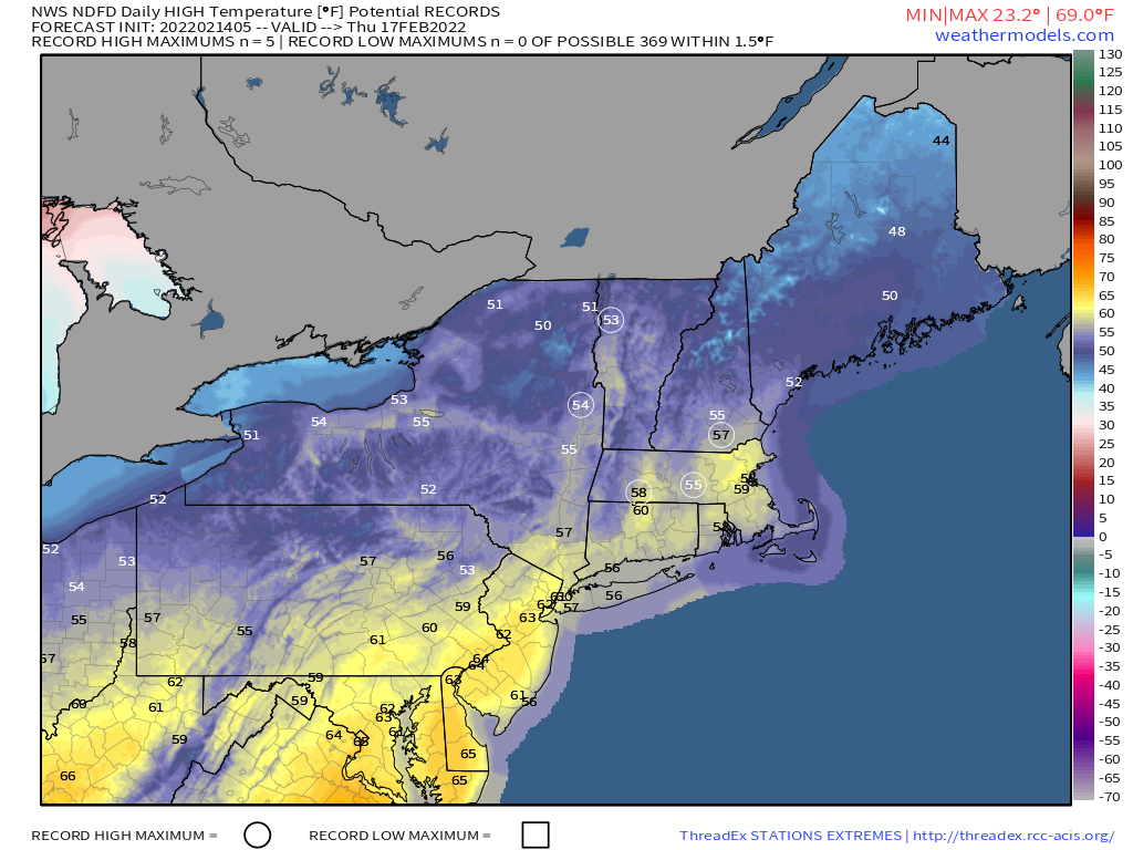
High pressure builds in behind this system on Monday with much colder weather. Despite sunshine developing in the afternoon, temperatures will only rise into the lower to middle 20s for highs, with single numbers and lower teens likely Monday night as skies clear out and winds die down. Tuesday also looks chilly, though likely a few degrees milder, but a big warmup is likely for the middle to latter half of the week. In fact, we could make a run at 60 again on Thursday, before another system brings in some rain.

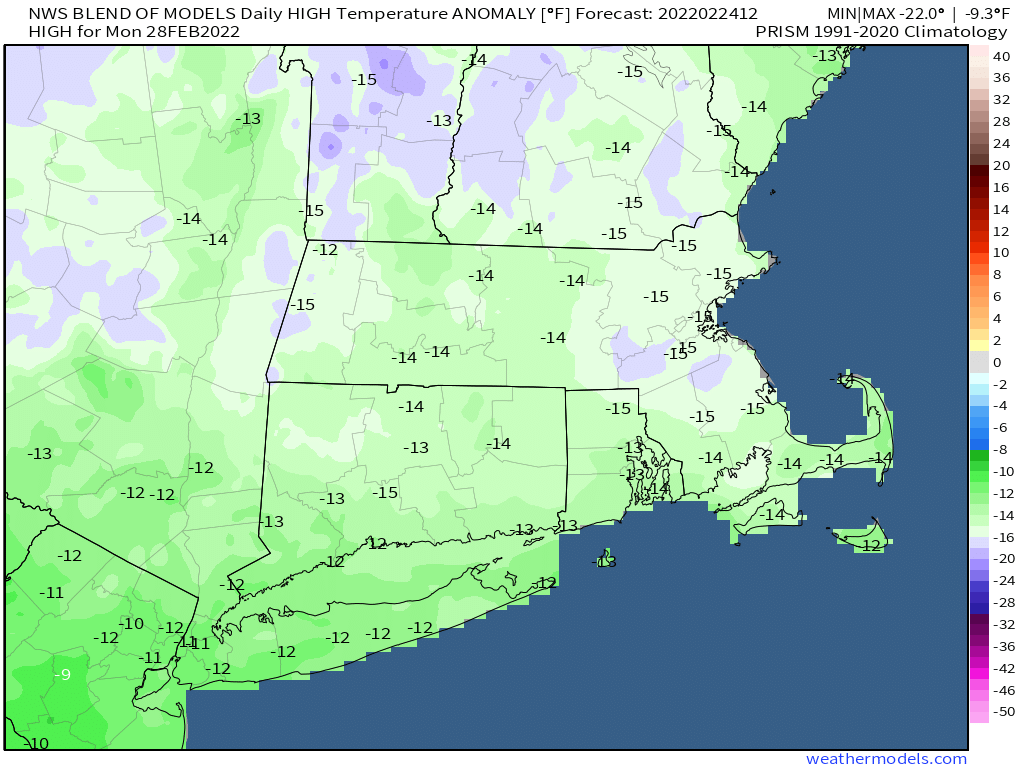
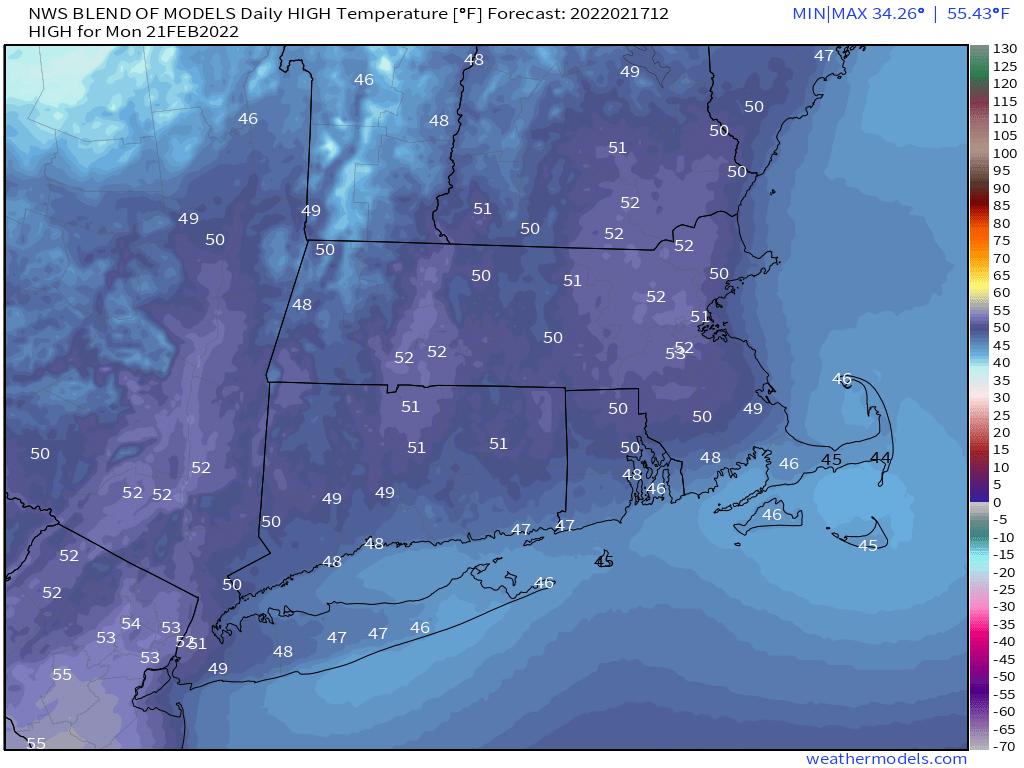
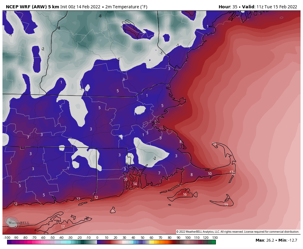
Tuesday morning looks rather chilly across the region. Image provided by Weathermodels.com.

There are some indications that this arctic blast for Monday and Tuesday could be the last really cold blast of the winter. Oh, it’ll still be cold, it’s only mid-February after all, but days with highs in the 20s and lows in the single numbers or below zero may be done for the year, though this is far from a guarantee. We’ve been known to have arctic blasts into March and even early April, though with the increasing sun angle, they tend to lose their staying power. This does not mean that winter is over, not by a longshot. We still can get snow around here well into April and even May if things set up properly. The longer range models are indicating that a milder pattern should start to take hold soon, and last into March. However, these same models also still show the threat for snow well into March, so don’t go putting away the winter gear just yet.

Weekend Outlook: February 11-14, 2022

A couple of relatively mild days are expected, but changes are on the way again.

A couple of weak systems will cross the region over the next couple of days, but aside from some clouds, the most noticeable impacts will be mild temperatures ahead of each of the systems. In fact, many parts of the region could top 50 degrees on Saturday. However, a stronger cold front will move through late Saturday, bringing an end to our mild weather. As that front moves offshore and colder air settles in, a wave of low pressure will ride along the front on Sunday. While it will stay well south and east of us, it should be close enough to spread in some light snow or snow showers during the day on Sunday, especially south of Boston. This won’t be a major snowstorm, but an inch or two may accumulate across parts of southeastern Massachusetts and Cape Cod. As the system pulls away, snow will end Sunday night, and we’ll clear out on Monday, setting up a very chilly day despite increasing sunshine.

A little snow is possible on Sunday, especially south of Boston. Image provided by WeatherBell.

Thursday night: Clear skies. Low 24-31.

Friday: Sunshine to start the clear, clouds start to move in during the afternoon. High 42-49.

Friday night: Mostly cloudy. Low 34-41 during the evening, temperatures rise a little overnight.

Saturday: Partly sunny. High 49-56, a little cooler across Cape Cod.

Saturday night: Becoming cloudy again, light snow or snow showers may develop towards daybreak. Low 21-28.

Sunday: Cloudy and colder with light snow or snow showers expected, especially south of Boston. High 27-34.

Sunday night: Mostly cloudy, light snow or snow showers ending. Low 8-15.

Monday: Cloudy early, skies start to clear out in the afternoon. High 18-25.

Weekly Outlook: February 7-13, 2022

Much of the upcoming week will be dry and mild, but there are some exceptions.

A weak low pressure system will pass south and east of New England later today and tonight. It will spread some light rain into the area, though temperatures will be marginally cold enough for some light snow across the interior, mainly north and west of I-495. Rain ends late tonight, followed by gradual clearing on Tuesday. After that, we’ll have generally dry and mild weather through the remainder of the week, though some disturbances will spread in some clouds and possibly a few showers at times. We may turn colder again next weekend, but there are no big storms in sight.

Any snow today and tonight will be across the interior. Image provided by WeatherBell.

Monday: Cloudy with showers developing, mixed with snow across the interior. High 35-42.

Monday night: Cloudy with rain or snow showers gradually ending. Low 29-36.

Tuesday: Any lingering showers end early, skies start to clear out late in the day. High 38-45.

Tuesday night: Clear skies. Low 17-24.

Wednesday: Sunshine and a few afternoon clouds. High 35-42.

Thursday: Intervals of clouds and sunshine, slight chance for a shower. High 42-49.

Friday: Partly to mostly sunny. High 37-44.

Saturday: Partly sunny. High 42-49.

Sunday: More clouds than sun, much cooler. High 28-35.

Weekend Outlook: February 4-7, 2022

It’s mild today, but a messy Friday is on the way.

A strong cold is making its way toward the region this afternoon. We’ll have some rain ahead of it tonight, and the rain may be quite heavy. The combination of rain and mild temperatures will help to melt a lot of the snow that remains from last weekend’s blizzard. The front moves through this evening, and colder air will slowly make its way into the region early on Friday, first at the surface, then aloft. As temperatures drop, the rain will change to freezing rain and then sleet from north to south. With the roads already wet from the rain and temperatures dropping, a flash freeze is likely, and it will unfortunately be timed for the morning commute. If you’re going to be out in the morning, use plenty of caution, as untreated surfaces will become very icy quickly.

Much of the region will receive 1.5-2.0 inches of rain tonight and Friday. Image provided by Weathermodels.com

Temperatures will continue to drop during the day, with the freezing rain and sleet likely ending as some wet snow, mainly north of the Mass Pike. Everything winds down in the evening, then skies gradually clear out at night as high pressure builds in. This sets up a sunny but cold Saturday across the region. The high slides off to the east for Sunday and Monday, keeping us dry, but allowing temperatures to begin to moderate once again.

Saturday night looks quite chilly across the region. Image provided by WeatherBell.

Thursday night: Rain, possibly heavy at times, changing to freezing rain and sleet late at night, mainly across southern New Hampshire and northern Massachusetts. Low 26-33 north of the Mass Pike, 34-44 south of the Pike.
Friday: Rain and freezing rain changing to sleet, and eventually some wet snow north of the Mass Pike. Temperatures dropping during the day.

Friday night: Wintry mix ending, some clearing late at night. Low 12-19.

Saturday: Becoming mostly sunny, breezy, and cold. High 19-26.

Saturday night: Clear and cold. Low -7 to 0 north and west of Boston, 1-8 south of Boston.

Sunday: Sunshine and some afternoon clouds. High 24-31.

Sunday night: Partly cloudy. Low 9-16.

Monday: Partly sunny. High 34-41.

Weekly Outlook: January 31 – February 6, 2022

After a snowy weekend, quiet weather will settle in for a few days.

The week starts off on a rather chilly note with high pressure in control, but as it slides off to the east, temperatures will moderate for the next few days. By Wednesday, many locations could top 40 degrees. This will help to melt some of the mounds of snow across the region, but remember, with temperatures dropping below freezing at night, anything that melts will ice back up.

Wednesday could be relatively mild by early February standards. Image provided by WeatherBell.

The next storm system approaches on Thursday, and it looks a bit complicated. A cold front will bring colder air back into the region and a wave of low pressure will ride along it, possibly passing south of the region. With warmer air in place to start, we will likely see precipitation start as rain, but a change to sleet and/or freezing rain is possible, especially across the interior during Thursday night and Friday. We could see a change to snow before everything winds down Friday afternoon. We’ll obviously have a better handle on this storm later this week. High pressure then builds in for the weekend with cold and dry conditions.

Monday: Sunshine and a few clouds. High 24-31.

Monday night: Clear to partly cloudy. Low 4-11.

Tuesday: Partly sunny. High 30-37.

Tuesday night: Partly to mostly cloudy. Low 21-28.

Wednesday: Mostly cloudy. High 38-45.

Thursday: Cloudy with rain developing, changing to sleet and/or freezing rain across the interior. High 39-46.

Friday: Wintry mix possibly ending as snow. Temperatures dropping into the 20s and 30s during the day.

Saturday: Becoming partly to mostly sunny. High 18-25.

Sunday: A mix of sun and clouds. High 25-32.

Storm Update: Blizzard Warnings

Saturday is not going to be a pretty day around here, but most of you already knew that. There are some changes to our forecast though. Once again, we’ll start with the basics (which really haven’t changed), then work our way into the details (which have changed a bit).

Blizzard Warnings are in effect from coastal Maine to the Delmarva Peninsula. Image provided by Pivotal Weather.

Low pressure will develop off the Southeast coast this afternoon and will head up the Eastern Seaboard tonight and Saturday, rapidly intensifying as it does so. The system will likely pass just south and east of Nantucket Saturday night, and pull away from the region on Sunday. A few snow showers are possible today as a cold front moves through, completely unrelated to the storm. What that front will do is bring colder air back in, so that we’ll be dealing with all snow across nearly all of the region, except possibly Nantucket and Outer Cape Cod.

OK, let’s get to the details. We’ll start with temperatures. North and west of Boston, temperatures will likely be in the teens for much of the storm, resulting in a fluffy snow. This will make cleanup easier, but also make it easier for accumulations to pile up quicker. South of Boston, temperatures will be in the 20s to start, but will drop during the day, so we’re also looking at a fluffier snow here as well. Across Cape Cod, temperatures will be closer to freezing, so it’ll be a wetter snow, with the possibility of rain mixing in, depending on how close the storm actually tracks. The general rule is that 1 inch of liquid equals about 10 inches of snow, which works fine with temperatures close to freezing. The colder you get, the higher the ratio gets. When temperatures drop into the teens, the ratio can get to 20:1, which means 1 inch of liquid results in 20 inches of snow. We’re not sure it’ll get that high, as there are other factors involved beyond the temperature at the ground, but it is certainly possible. The other thing to keep in mind is that the temperatures, combined with strong winds (see next paragraph), will result in very cold wind chills, so keep this in mind if you’re heading outside to do some shoveling during the storm.

Wind chills will be near or below zero across the region by Saturday evening. Image provided by WeatherBell.

Next, we’ll get to the winds and coastal flooding. As the storm gets cranked up south of the region, winds will pick up on Saturday. Sustained winds of 15-25 mph are likely inland, with sustained winds of 20-40 mph along the coast. Wind gusts of 40-50 mph are likely inland, but along the coast, wind gusts of 50-70 mph seem likely, with higher gusts possible, especially across Cape Cod. Some trees and power lines could come down, so be prepared for power outages, but with a fluffier snow, there might be less widespread than you’d normally expect. The winds, combined with astronomical high tides, will result in some coastal flooding, especially at northeast and north-facing coastal areas during both the morning and evening high tides on Saturday.

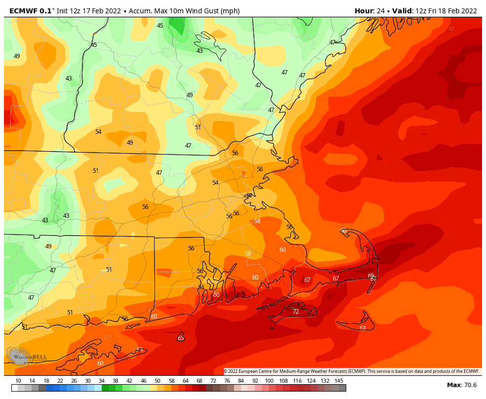
Wind gusts could exceed 50 mph across much of the coastal plain. Image provided by WeatherBell.

With strong winds and heavy snow (more on that in a moment), blizzard conditions are expected on Saturday. If you don’t have to go out, then don’t. Whiteout conditions will make travel nearly impossible during the afternoon and evening. The National Weather Service has issued a Blizzard Warning for most of eastern Massachusetts and Rhode Island, as well as the New Hampshire Seacoast and coastal Maine.

Sustained winds or frequent gusts ≥ 35 mph AND considerable falling and/or blowing snow frequently reducing visibility < ¼ for ≥ 3 hours.

Blizzard conditions need to be the predominant condition over a 3 hour period.

Official definition of a Blizzard Warning from the National Weather Service

Now to the part that you’ve all been waiting for – how much snow is going to fall? If you read our Weekend Outlook yesterday, or are a regular reader of the blog, then you know that we are normally very conservative in our snowfall forecasts – no hype here. Well, many of the forecast models continue to forecast insane snowfall totals, and most of the guys on TV are buying in. With that in mind, we are issuing an Extreme Hype Warning.

When an Extreme Hype Warning has been issued, it means you’ll see blanket coverage from the network stations around here, hourly updates even when they go to regular programming, and of course, obligatory live shots from (take your pick):

  • The side of an Interstate
  • Logan Airport
  • A local DPW salt pile
  • A beach showing the rough surf and coastal flooding
  • A Dunkin Donuts where they are talking to a plow operator
  • All of the above

You’ll also get network reports about how the snow is creating chaos in New York City, how it put Washington at a standstill (due to the 1-3 inches they’ll get), and possibly how it dumped heavy snow (a.k.a. 1 inch) on parts of the Southeast.

As for our forecast? We’re going to raise forecast amounts from what we had yesterday, but not to the levels that most of the media is forecasting. Light snow may develop by midnight along the South Coast, spreading northward over the ensuing few hours, reaching southern and central New Hampshire and southern Maine by 3-5am. Between about 10am and 7pm, it’s going to snow rather heavily. Snowfall rates of 1-2 inches per hour will be likely in many areas. However, there will be some embedded bands of intense snowfall, with snowfall rates of 2-4 inches per hour. If you’re under one of these bands for any length of time, your totals may end up higher than our forecast, while areas outside the band a few miles away have significantly less snowfall.

OK, we’ve rambled on enough, let’s go to the actual forecast totals:

Central NH (Lebanon/Laconia): 4-8″
Southern NH/Central MA (Concord/Manchester/Nashua/Fitchburg): 10-15″
Merrimack Valley/495 Belt/NH Seacoast (Portsmouth/Haverhill/Lowell/Framingham): 15-20″
I-95 corridor (Beverly/Boston/Providence): 18-24″
Southeastern MA/Cape Cod (Brockton/Weymouth/Plymouth/Taunton/Fall River): 20-26″ with some totals in excess of 30″ possible.

The National Blend of Models continues to be closest to our thinking for snowfall totals. Image provided by Weathermodels.com

Once the storm pulls away, dry and colder conditions settle in for Sunday and Monday, before temperatures start to moderate. There are some indications for a big warmup late-week and a storm that will bring in rain, but it’s still several days away, so we wouldn’t put too much stock into that just yet,

Weekend Outlook: January 28-31, 2022

We’ve certainly got an eventful weekend coming up across the region.

Another chilly night is expected as high pressure slides offshore, but clouds will start to move in, and temperatures may actually start to rise after midnight as winds shift into the south and southwest. Friday will feature plenty of clouds and somewhat milder temperatures, but an approaching cold front may produce a few snow showers during the afternoon. This brings us to the main event.

Winter Storm Watches are in effect for much of the coastal plain in the Northeast and Mid-Atlantic states. Image provided by Pivotal Weather.

We’ll give you the general idea first, then get into specifics in the next paragraph or four. Low pressure will move up the East Coast Friday night and Saturday. There are still some questions as to exact track and strength, but we are narrowing the possibilities. At this point, it looks like the storm will track just south and east of Nantucket, which means that this will be all snow for everyone, except possibly Nantucket and the Outer Cape. The storm should pull away before daybreak Sunday, with clearing Sunday afternoon, then high pressure builds in with sunshine and colder weather on Monday.

There is still disagreement among the models as to how close the low gets to Nantucket. Images provided by Pivotal Weather.

Now, let’s get to the details of the storm. As winds shift into the northeast Friday evening, the onshore flow may produce some flurries or snow showers across the region, but these won’t do much more than whiten the ground. The steady snow will spread across the region between 2 and 5am. Between about 10am and 10pm, we’ll have snow falling moderate to heavy at times, especially near the coast and south of Boston. There will be some embedded bands of intense snowfall, falling at the rate of 1-3 inches an hour, but picking out where those will develop is a fool’s errand at this point. The snow should taper off in the evening, and end from west to east between 3 and 6am Sunday. We’ll detail the amounts in a bit, as snow is not the only concern with this system.

As the storm rapidly intensifies, winds will ramp up, with sustained winds of 15-25 mph inland, and 20-40 mph along the coast and south of Boston. Wind gusts in excess of 50-60 mph are possible, especially across Cape Cod and the Islands. This will result in significant blowing and drifting snow, with blizzard conditions possible. It also will increase the threat for power outages, with trees and power lines coming down. The winds, combined with astronomical high tides (Tuesday is the New Moon), will result in coastal flooding, possibly moderate to major coastal flooding, especially at east and northeast-facing coastlines.

Wind gusts of 40-50 mph are likely across the region. Image provided by Weathermodels.com

Another factor will be temperatures. We mentioned that this will be all snow for nearly all of the region, but it’s looking like it’ll be a fluffy snow for many of us. This is both good and bad. It’s good, because it makes it a lot easier to clean up, but bad, because it allows the snow to pile up even faster. The reason it will be a fluffy snow is because it’s going to be quite chilly. Areas north and west of Boston may stay in the teens all day Saturday, with 20s from Boston southward. Add in the strong winds, and you’re looking at wind chills in the single numbers and below zero. Keep that in mind if you’re going to try and clean up the driveway a few times during the storm.

OK, we’ve gone over the timing, the winds, the coastal flooding, the temperatures, did we miss anything? Oh yeah, how much to expect. You’ve probably seen or heard that there are many models forecasting some outrageous amounts of snow. Well, as is usually the case, you won’t find that here. Oh, we’re still expecting a rather potent storm, but if you really expect widespread 2-3 feet, then we’re going to disappoint you. Since we’re still 36 hours from the start of the storm, this could still change, and we’ll likely issue another blog post tomorrow, but here’s our current thinking:

Central NH (Lebanon/Concord): 2-6″
Southern NH/Central MA (Manchester/Nashua/Fitchburg): 5-10″
Merrimack Valley/495 Belt/NH Seacoast (Portsmouth/Haverhill/Lowell/Framingham): 8-12″
I-95 corridor (Beverly/Boston/Providence): 10-15″
Southeastern MA/Cape Cod (Brockton/Plymouth/Taunton/Fall River): 12-18″ with some totals in excess of 20″ possible.

The National Blend of Models is fairly close to our thoughts in terms of snowfall. Image provided by Weathermodels.com

Thursday night: Becoming partly to mostly cloudy. Low 15-22, but temperatures may start to rise after midnight.

Friday: Cloudy with a chance of snow showers. High 30-37.

Friday night: Snow showers becoming a steady light snow, becoming breezy. Low 18-25 north and west of Boston, 26-33 south.

Saturday: Windy with snow, heavy at times. Temperatures will hold steady or drop during the day.

Saturday night: Snow tapers off, ending before daybreak, winds gradually diminish. Low 3-10.

Sunday: Gradual clearing, still breezy. High 19-26.

Sunday night: Clear to partly cloudy. Low 2-9.

Monday: Partly to mostly sunny. High 25-32.

Once More Unto the Breach, Dear Friends

Yes, the rumors are true, a storm system is on the way for the weekend, and there is the potential for some significant snowfall. Nothing is definite yet though, so let’s separate the truth from the exaggeration. First, we’ll set the table for what’s going to happen.

Low pressure will move out of the Gulf of Mexico and up the East coast Friday into Saturday while rapidly intensifying. (You’ll hear the word bombogenesis used for sure.) Before that happens, a cold front will move across the Northeast on Friday, producing some snow showers. These are unrelated to the storm system, and could drop an inch or less on the region. That front will likely dissipate south of New England as the approaching coastal storm overwhelms it. Meanwhile, behind that front, a large high pressure system will build into southeastern Canada, locking cold air into place.

Friday’s cold front will drop less than 1″ of snow on most of the region. Image provided by WeatherBell.

OK, now that we have the basic setup, let’s delve into a few things that we’ve heard or read today and how truthful they are.

Statement: An historic blizzard could set records across the Northeast this weekend.
Truth: Yes, some models are showing a rather extreme storm system with the potential for extraordinary snowfall totals. But, it’s still 4 days away, and a lot can change. This is far from a given. We’ll explain below.

Statement: This will be all snow for the entire region.
Truth: Again, given that there is still some uncertainty in the track, a mix or change to rain can’t be ruled out, especially for Cape Cod, and possibly eastern Massachusetts of Rhode Island. Again, read on for more details.

Statement: Significant coastal flooding is likely.
Truth: This one rings true. With a New Moon on Tuesday (we were that close to a Duran Duran song), tides will be running astronomically high. Add in strong east to northeast winds pounding the shoreline for 2 and potentially 3 high tide cycles, yes, coastal flooding is likely, especially the normally vulnerable locations.

OK, now let’s get into what could happen on Saturday. A rapidly intensifying storm system will head up the East Coast, producing strong winds and heavy snow ahead of it. While most of the models are fairly similar to each other with a track close to the “benchmark” (40N/70W), this is far from definite. The storm could end up farther offshore, which would limit the how far inland the heavy snow extends. The storm could also track closer to the coast, which would allow milder air to move in and change the snow to rain, how far inland the change could occur would be determined by the track obviously. This is the type of the detail that won’t become clearer for another day or two at best.

Our friends at the National Weather Service office in Norton, MA explain the potential error in the model forecast nicely.

One factor in determining that track? The upper-level energy responsible for the storm is just moving into from the Pacific tonight. Why is that important? Let us explain. Every day around the world, we send up weather balloons twice a day to sample the upper atmosphere. This is done at 00UTC and 12UTC everywhere (7am/7pm in EST). This data is then fed into the models. The upper-level energy that will create our storm has been over the Pacific for the past several days, where there is little data. In the past, we would get observations from planes as well to supplement the balloons, especially over the water, where there are no balloon launches obviously. Well, since the pandemic, air traffic is less than half what it used to be, so there are a lot less of those aircraft observations. So, we are basically at the mercy of the balloon data. Once that upper-level energy moves over land, as it is doing now, it will be into the balloon network. The models should now start to have a better idea of its structure and converge on a solution.

The kink in the flow near the British Columbia coast and the one over northern Alberta will eventually combine to create our weekend storm. Once they’re over areas with more data, we’ll have a better idea how strong they are. Image provided by the University of Wyoming.

Complicating things is the fact that some models show the system being captured by the upper-level trough of low pressure, or even getting stuck underneath a “cutoff” upper-level low pressure system. (It’s called that because it becomes cut off from the jet stream.) This would potentially allow the low to stall out south of New England for a while, prolonging the impacts to the region. How strong the storm gets (also up for debate) could determine whether or not this scenario occurs, but will also impact how strong the winds will be and in turn the amount of coastal flooding that may occur. Right now, the timing of the system looks to be generally between midnight Saturday morning and midnight Sunday morning, but obviously, this is far from definite.

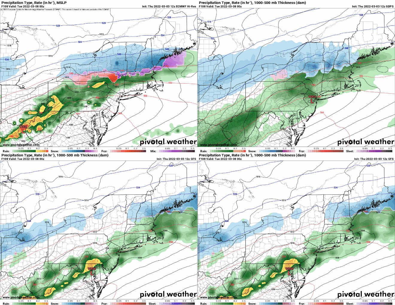
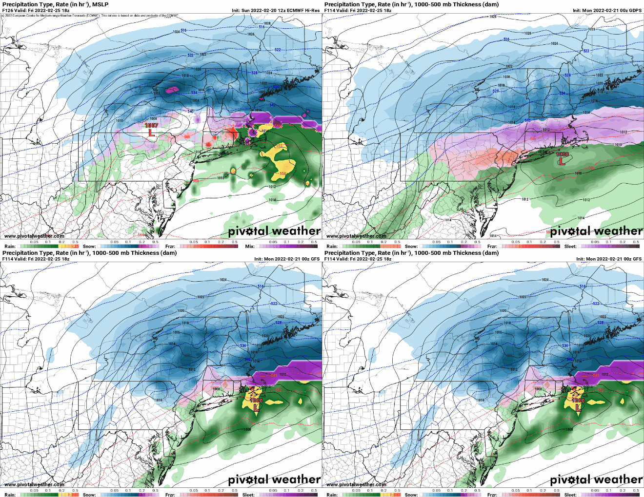
The models still do not agree on the strength or location of the storm Saturday afternoon. Images provided by Pivotal Weather.

As for how much snow will fall? Well, we’re not even going to attempt to put any numbers down yet. There is still FAR too much uncertainty. In addition to all the factors we talked about above, another one is temperature. Some models keep the cold air locked into place, with temperatures in the teens and 20s for much of the region during the storm. This would result in a much fluffier snow, making it a little easier to clean up, but also allowing it to pile up a lot quicker. If the warmer air does move in, especially near the coast, then temperatures could be near or even above freezing in spots. The general rule is that 1 inch of liquid precipitation equals 10 inches of snow. This holds true at temperatures close to freezing. With temperatures in the lower 20s, that 1 inch of liquid could result in 20 inches of snow. Most of the snow maps you may see online are ones that use the 10:1 ratio only, so in colder scenarios, like this one could be, they will underestimate the amount of snow.

If you really want, there are plenty of people all over Facebook, Twitter, and the web, who are more than happy to share all of those various model forecast maps, no matter how far-fetched they may seem. We’re not going to do that. We’ll just say that the potential is there for this to be a significant snowstorm.

Given all of this, we are issuing an Extreme Hype Watch for the StormHQ viewing area. An Extreme Hype Watch is issued when conditions are favorable for media hype of an event to reach extreme levels within the next 48-72 hours. If conditions warrant, a Hype Advisory or Extreme Hype Warning will be issued as the event draws nearer. We’ll hazard an initial attempt at amounts when we publish our Weekend Outlook Thursday afternoon. In addition, well do another full blog post on Friday.

Weekly Outlook: January 24-30, 2022

Another chilly week is expected, but trouble could be lurking next weekend.

A dry, but chilly day is expected today as high pressure builds in, but it won’t stay that way for long. An Alberta Clipper will be heading this way, sending clouds back in late today, with some snow showers late tonight into early Tuesday. Temperatures may be marginally warm enough to change the snow to rain across Cape Cod and the South Coast. Any accumulation should be an inch or less. Once that system moves by, high pressure builds back in for Wednesday and Thursday with much colder weather once again. Another weak system may bring in a few snow showers on Friday as temperatures moderate a bit. This brings us to next weekend.

Temperatures will remain below normal for most of the upcoming week, but the coldest air will stay to our north and west. Image provided by WeatherBell.

For several days now, the models have been indicating the potential for a significant storm system somewhere near the East Coast around Saturday, January 29. We’ve mentioned more times than we can count that the models aren’t trustworthy beyond about 2 or 3 days right now, but they have all had the same signal for quite some time, which gives us increased confidence that there will be some sort of storm, and it will probably be potent. However, models are showing little consistency beyond that in terms of how strong it will be, where it will track, what areas (if any) it might impact, and what impacts (if any) that it will have. At this point, everything is on the table, from a swing and a miss with the storm heading out to sea, to an inland runner, where we end up on the warm side with heavy rain and mild temperatures, to a mix of snow, sleet, freezing rain, and rain with the storm tracking right over us, to a full-fledged blizzard with the classic track right up the coast. Depending on which model you look at, and which run of that model, they have all indicated any and all of these scenarios at one point over the past several days. So, at this point, it is impossible to make a forecast, because frankly, we just don’t know, and probably won’t have a better idea of what to expect until at least mid-week. By the time we issue our Weekend Outlook on Thursday, we *should* have a decent idea of what will happen, but even that isn’t definite. So, stay tuned….

This is the last 5-days worth of forecasts from the GFS model that are all valid for this Saturday afternoon. Images provided by Tropical Tidbits.

Monday: Intervals of clouds and sun. High 27-34.

Monday night: Mostly cloudy with some snow showers possible. Low 18-25, temperatures may start to rise a bit after midnight.

Tuesday: Mostly cloudy with morning snow showers, possibly mixed with rain near the South Coast and Cape Cod, some afternoon sunny breaks develop. High 36-43.

Tuesday night: Becoming clear. Low 12-19.

Wednesday: Mostly sunny. High 19-26.

Thursday: Sunshine and some afternoon clouds. High 22-29.

Friday: Mostly cloudy with a chance for snow showers. High 32-39.

Saturday: Partly to mostly _____ with a chance of _____. High 26-33.

Sunday: Partly to mostly _____ with a chance of _____. High 24-31.

Weekend Outlook: January 21-24, 2022

We’ve actually got a fairly simple, but cold, forecast coming up for the next several days.

A cold front crossed the region earlier today, and that cold air will continue to rush in tonight, resulting in a very chilly night as skies clear out across parts of the area. High pressure builds in for Friday with sunshine and cold temperatures, except across Cape Cod where northerly winds blowing over the relatively mild ocean will result in some ocean-effect snow showers. Another chilly night is likely Friday night, but as winds turn more into the northeast, some of those ocean-effect snow showers could move into parts of Plymouth County. Saturday remains mostly sunny but not quite as chilly, though we will still have some ocean-effect snow showers across Cape Cod and parts of Plymouth County. Temperatures start to moderate a bit on Sunday (but will remain chilly), then another cold front moves through late Sunday, bringing colder air back in for Monday.

Ocean-effect snow could produce an inch or two across parts of southeastern Massachusetts and Cape Cod. Image provided by WeatherBell.

Thursday night: Gradual clearing, mainly north and west of Boston. Low 0-7 north and west of Boston, 8-15 south of Boston, milder across Cape Cod.

Friday: Becoming partly to mostly sunny, except cloudy with some snow showers across Cape Cod and the Islands. High 17-24.

Friday night: Cloudy with some snow showers across southeastern Massachusetts and Cape Cod, clear to partly cloudy elsewhere. Low -2 to +5 north and west of Boston, 6-13 south of Boston, milder across Cape Cod.

Saturday: Mostly cloudy with some snow showers across southeastern Massachusetts and Cape Cod, partly to mostly sunny elsewhere. High 21-28.

Saturday night: Plenty of clouds. Low 8-15.

Sunday: Intervals of clouds and sun. High 28-35.

Sunday night: Becoming partly cloudy. Low 11-18.

Monday: Mostly sunny. High 24-31.